

 Timeline
Home
Bounty Logbook
Bounty Logbook Remarks (GM)
Timeline
Home
Bounty Logbook
Bounty Logbook Remarks (GM)

Revised May 26 2021
I have redone the logbook pages to more closely resemble the originals and to include various observations that I had previously left out. Nothing is omitted from these pages, they are complete.
The logbook is actually comprised of three volumes, the first two covering the
voyage of the Bounty up to the Mutiny, and the third the voyage in the Bounty's launch.
The pages of the first two volumes were hand numbered, the third not. The left facing
page was numbered in the upper left hand corner, the right facing page in the upper
right hand corner, and are shown here thusly:
xxx)
(xxx
However, these webpages are organized by date and logic rather than by logbook pages, so that a webpage may contain either a single page, several pages, or even part of a page.
On many of these pages you will see Meridn.Alt. Center.
This means the Meridian Altitude taken from the center of the sun's disk rather than
the edge.
Center.
This means the Meridian Altitude taken from the center of the sun's disk rather than
the edge.
Below are links to every page by date, but first here are links to siginificant entry points.
| H | K | F | Courses | Winds | Ther. | Rems Monday 6th. April 1789 | Observations |
|---|
H Hours. As stated elsewhere, at sea the day ran from noon to noon and was 12 hours ahead of land time. (The reason for this was that the errors in dead reckoning for the preceding 24 hours were corrected by the solar observation at noon.) The first 12 hours are the afternoon of the day previous to the given date, and the next 12 are the morning hours of the given date.
K Knots. The ships speed, or headway through the sea.
F Fathoms. The depth of the water in fathoms, except when at sea. See below.
Ther. Thermometer. The temperature in the air, unless otherwise noted.
Rems. Remarks. Usually include the date, and sometimes the location.
Observations Various celestial and navigational remarks.
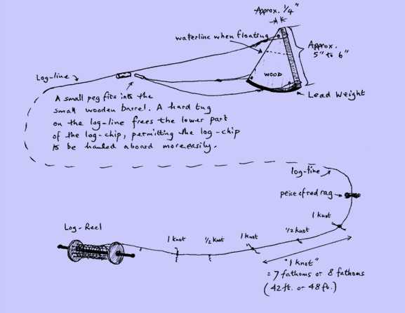
The ship’s headway, or speed through the water, was measured in 'knots,' and the term is derived from the knots located on the log line which was run out every hour. This measured the distance the ship had run from a fixed point in the water during a fixed time, both distance and time being the same relative fraction of a nautical mile and an hour. For example, 50 feet is 1/120th of a 6,000 foot nautical mile, and 30 seconds is 1/120th of an hour.
The fixed point in the water was a wooden 'log' which was approximately a quarter section of a circle, five to six inches on its straight edges, and ¼″ to ½″ thick, and weighted on its curved edge with lead so that it would sit vertically in the water relatively motionless. The log, attached to approximately 150 fathoms of thin line on a reel held by a seaman (see figure), was dropped over the lee side of the stern of the ship every hour. As the line ran out a red rag appeared on the line, indicating that the log was now more than a ship's length aft of the ship, and it should be relatively stationary in the water. The log was now marked with knots every 50 feet of its length. As the red rag appeared the reel-man shouted "Turn!", and a seaman holding a 30-second glass turned the glass. The reel-man then counted the knots as they ran off the reel. When the seaman holding the 30-second glass saw the glass was empty, he shouted "Stop!" and the reel-man stopped the reel. The number of knots run out was then the speed of the ship. Because of its importance, a Midshipman or Master’s Mate usually supervised this operation.
Some logbooks had a column, HK, which was for half knots. The Bounty's does not. Instead, at sea, the Fathoms column was used to indicate the number of fathoms of log line between the knots. Thus, if the distance between the knots on the line was 48 feet, or 8 fathoms, a 7 in the Fathoms column would represent 7/8 of a knot to be added to the speed in the knots column.
(There is an entry in the logbook kept by Francis Godolphin Bond, First Lieutenant of the Providence, "Measured the Log line and found it right at 46 feet 8 inches.")
First, the compass is divided into 32 named points, as in the compass rose at the bottom of this page. Each of these points is divided into quarter points. In these pages you will see such bearings as NNE¼E and NW½N. The first is a quarter point east of north-northeast. The second is two quarter points north of northwest. The first intials are the named compass point or the origin, then the fractional point from the origin, and finally the direction from the origin. Similarly, there are quadrant bearings such as N62°E and W30°S. Again, the first is one of the four cardinal points, N, S, E, and W, then a number of degrees from 1 to 89, and finally a direction. N62°E is 62° east of north and W30°S is 30° south of west. If you see something like N.52W, the '.' is a period for the N and not a decimal point. The keeper of the log, whether Mr. Bligh or Mr. Samuel, was never consistent. Sometimes there are periods and sometimes not, sometimes there is a ° and sometimes not.
This also resembles the compass card, kept in the compass box below the magnetized needle, without my labels of course.
 Timeline
Home
Bounty Logbook
Bounty Logbook Remarks (GM)
Timeline
Home
Bounty Logbook
Bounty Logbook Remarks (GM)