


Some Place Names from
Early Voyages to Patagonia
and Tierra del Fuego
John Woram
From the early years of the sixteenth century, European visitors to Patagonia and Tierra del Fuego have bestowed names on places visited. Catholic voyagers often applied the name of a saint whose feast day was celebrated on the day of their arrival at that place. Other locations were named in honor of the voyager, of an event connected with the voyage, or to honor some person or place back home. Some names have appeared and disappeared almost at once, othes have hung on for a bit before being replaced by some other name, and still others have secured a permanent place on the map.
As its name suggests, the “Expedition” column identifies the expedition on which each place name originated, sometimes followed by the name of the person (in parentheses) who named that place. A (?) following the name indicates the name is thought to be correct, but remains uncertain pending further research. The text that follows gives whatever details are available about the significance of the name.
Some place names associated with the Loaysa expedition may have originated with the Magellan expedition a few years earlier, even if those names were not mentioned by Pigafetta or any of the others on that expedition. After Magellan's death, Juan Sebastian del Cano brought the ship Vittoria back to Spain, and a few years later joined the Loaysa expedition. In the absence of information to the contrary, it's possible that on the latter expedition he informed pilot Martin de Uriarte of a name, or names, originating on the former expedition.
This list provides information on older names no longer in use, for which information is not readily available elsewhere. There are also a few cases where a more-recent name now appears at a location other than where it was originally placed. In several of these, a link leads to another file in which greater detail is provided.
The following list is not complete, and no doubt never will be—there are just too many names to set down. But as time goes by more names will be added as time permits.
Neither FitzRoy's Narrative nor Darwin's Voyage identify the location where the Beagle's boats narrowly escaped destruction due to a glacier calving. However, FitzRoy was in the habit of naming places after people or events associated with the voyage, and his Appendix volume lists an “Avalanche Point” whose coordinates serve as a guide to place this location in Google Earth. Actually, his coordinates were off a bit, as seen by his coordinates for the known Devil Island and Cape Divide (red circles). If we assume a similar error for Avalanche Point and move all three as a single group so that the former two line up with their known locations (green circles), then the latter lines up with the point of land in front of Glaciar Italia.
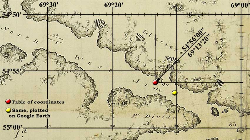
The above detail view from FitzRoy's 1835 Part of Tierra del Fuego chart shows the approximate location of Avalanche Point, according to the coordinates on his chart (red button). However, a Google Earth 3D view places these coordinates a bit farther SE (yellow button). In other words, his coordinates are off by about 1' latitude, 3' longitude.
In her European Encounters… (p. 210), author Anne Chapman places the incident farther west: “… the two boats were hauled on shore about 200 yards from a glacier (called Romanche).” But this appears to be a mis-interpretation of FitzRoy's original text:
“Our boats were hauled up out of the water upon the sandy point, and we were sitting round a fire about two hundred yards from them,… .”
That is, the men were seated at that distance from their boats, and not from the glacier. In fact, Darwin's January 29th, 1833 Diary entry (p. 140, 1988 edition) states they were about a half-mile from the glacier.
The evidence presented here indicates that Glaciar Italia is the most likely location. As noted above, Darwin mentions the incident in his Diary, and later in the 1839 edition of his Journal of Researches. It appears at a different place in the 1845 edition and in the 1905 and later editions of Voyage of the Beagle.
The bay was named “Port of Good Success”§ by the de Nodal brothers on January 22, 1619.
§ In original, “…una muy buena Ensenada, ò Bahìa, que se llama Puerto de el Buen-Sucesso.” (p.65).
On modern charts it usually appears as Bahía Buen Suceso. Since its discovery it has been visited by many voyagers, including James Cook and Sir Joseph Banks, Robert FitzRoy and Charles Darwin, all of whom refer to it by the English “Bay of Good Success” (or similar).
See On the Locations of … for information.
See Rio de la Plata.
See Bahía Buen Suceso.
In 1615, Schouten and Le Maire set sail from the Dutch city of Hoorn in their ships Eendracht (Unity) and Hoorn, bound for the Strait of Magellan. After the Hoorn was destroyed by fire at Rio Deseado, the Eendracht continued south, eventually reaching the southernmost island in the Fuegian archipelago, which they named Hoorn. It is unknown if the name honored their lost ship, their home port, or perhaps both. In Spanish, the name has been mis-translated as “Cabo de Hornos” (note plural), although the Dutch “Hoorn” is not equivalent to “horn” (in English) or “horno(s)” (ovens, en español; thus, a meaningless “Cape of Ovens”). See Wikipedia for more details about the source of the Dutch name.
As Magellan's ships sailed through the strait that now bears his name, two expedition members gave it various names, as did at least two others some years later.
- Anonymous Portuguese: “We found ourselves in a strait, to which we gave the name Strait of Victoria, because the ship Victoria was the first that had seen it: some called it the Strait of Magalhæn, because our captain was named Fernando de Magalhæn.”
- Pigafetta (on entering the strait): “We found … a strait which we called the Cape of the Eleven Thousand Virgins.”§
- Pigafetta (later on): “We called this strait Pathagonico.”
- Magellan: (in his Order of the day) “Done in the Channel of All Saints, …”§§
- Sarmiento de Gamboa (1580): “The name of the Strait de la Madre de Dios is given to this Strait heretofore called de Magallanes.”
- Ringrose (1681): “We set our sails again, resolving to make for the Straits of St. Vincent, otherwise called the Straits of Fernando de Magellan.”
§ The Milan Ambrosian ms. has perhaps the clearest version of Pigafetta's account (p. 65 in Clark 1906 edition): “… we found a strait on the day of the eleven thousand virgins, whose head is called Capo de le Undici Millia Vergine because of that very great miracle.” In context, the name clearly does not refer to the entire strait, as in the other ms. translations. See Cape of the 11,000 Virgins below for more details.
§§ Magellan's “Channel of All Saints” refers to a passage within the strait, and not to the entire strait, which he left unnamed.
So, some called it by the Captain-General's name, others called it something else, and as noted, Magellan himself called it nothing at all.
As noted elsewhere, it was often the custom to name a place after the feast day on which an explorer arrived there, and some modern accounts state that Magellan's fleet “…travelled through [the strait] on 1 November or All Saints' Day.” But this is incorrect: Pigafetta's account states that they were “…within the strait … in the month of October.” The Genoese pilot's account (in Stanley) is more specific: “They made a stay in this strait from the 21st of October to the 26th of November.” In other words, by All Saints Day they had already been in the strait for some ten days, and thus it is an unlikely choice of name for the strait. Furthermore, all other known references are to a strait (or estrecho), and so it is unlikely that Magellan would call the strait a channel.
Pigafetta's account describes the location of the “river named Isles,” which is where Magellan wrote his Order of the Day.
From the evidence, it seems that the strait was not “officially” named during the expedition, and Pigafetta's own post-voyage sketch map labels the passage as “Streto Patagonico”—Magellan's name appears nowhere on his map. Chances are, the strait got its name as cartographers began adding “Strait of Magellan” to their maps after the expedition survivors returned to Spain.
Sarmiento's feeble attempt to rename it was ignored and Ringrose's “otherwise called” may have been an editing error. His intention may have been to write that they would “… make for the Straits of St. Vincent or of Magellan.” (See “In Search of San Sebastian” for more on Ringrose's familiarity with the general area.)
Pigafetta describes the location, but does not give it a name (pp.48-49).
… we went as far as thirty-four degrees and a third towards the antarctic pole … it is a river which has a mouth seventeen leagues in width, by which it enters the sea.
At Montevideo, the actual width of Rio de la Plata is about 62½ miles, or about 14-15 Spanish leagues. As for the place name, Francisco Albo's log book has the following entry: (p. 214).
Tuesday, 10th January [1520]: Our latitude came to 35° … the land is sandy; we gave it the name of Montevidi (now they call it … Santovidio). (Use link to see log book for further details.)
Albo does not explain the reason for the name given to the area, nor give the identity of those (“they”) who call it Santovidio. The latitude of the modern Montevideo, Uruguay is given as 34° 51' 29" S. (-34.858056).
See also Rio de la Plata.
On seeing the locals at Puerto San Julián, Pigafetta wrote that “The captain named this kind of people Pataghom,”§ and it didn't take long for the legend to spring up that Magellan named the surrounding area as Patagonia. But he didn't: As far as we know, Pigafetta's one-line quotation was the one-and-only time Magellan used the word. Over the years various explanations of the word's meaning have been given, usually as a reference to the people's large feet. But a more-likely explanation is that the people reminded Magellan of The Famous and Renowned Historie of Primaleon of Greece, a popular romance of his day, in which a mis-shapen creature is described, and “… to him we call Patagon, said to be engendered by a beast in the woods.” The romance was so popular in those days that no further explanation of the word was needed. Later on, Pigafetta labeled the area that included San Julián as “Regione Patagonia” and also labeled Magellan's strait as “Streto Patagonico.” So, although Magellan often gets the credit for naming Patagonia, it is really his chronicler who did the job.
§ Spelled “Pathagoni [in Pigafetta's French ms.], Pataghom, Patagon” (or similar) in various translations.
In Spanish, Golfo de Penas = Gulf of Sorrows, referring to the hazardous tasks of early vessels in navigating the dangerous currents, and coping with the tempestuous weather, so often encountered in this gulf.
In her European Encounters … Before and After Darwin, Ann Chapman writes (p. 103) that Pringle Stokes was to “… proceed north … to the turbulent Gulf Of Peñas.” In her “Notes” section she adds:
The word “peña” meaning cliff, crag or rock was originally misspelled in English as “pena” which signifies sorrow. However, Stokes and King use the correct spelling: “The Gulf of Peñas.” Nevertheless, the mistake of calling it “El Golfo de Penas” (The Gulf of Sorrow [sic, Sorrows]) is quite common, as for instance Mantellero, 2000: 190.
Actually, Stokes, King—and even FitzRoy—were mistaken in their “Gulf of Peñas” usage: the aptly-named “Penas” is correct, as explained by Mantellero, who refers to the above-mentioned difficulties encountered in the gulf which so often led to disaster. The correct “Penas” spelling is seen on two charts included with the King, Stokes et al Narrative, and on many other charts from the late 18th century until today, including the latest navigation charts published by Armada de Chile.
As a further argument against “Golfo de Peñas” (Gulf of Cliffs), that name would be meaningless here, as there are no cliffs near this gulf. Various points within the Gulf were surveyed by Pringle Stokes, as noted in Volume I of the Proceedings … .
As a point of interest, there is a Cabo Peñas  on the Atlantic coast of Tierra del Fuego—coordinates 53°51'30" S, 67°33'20" W.
The river has had several names over the years.
- 1516: Spanish navigator Juan Diaz de Solis discovered the river and named it Rio Dulce. He was subsequently killed by the local natives and his expedition returned to Spain.
- 1519: Both the Genoese pilot (Bautista) and anonymous Portuguese wrote that the river was given the name of St. Christopher which, according to custom would mean they arrived there on the feast day of a St. Christopher. But since there are no such feast days in January, the significance of the name remains unknown, pending further research.
- ca. 1526: Sebastian Cabot is said by some to have changed the name to Rio de la Plata, after the silver he acquired from the nearby Guarani tribe. However, Cabot biographer Francesco Tarducci states that the Portuguese “… told him that on this coast there was a river which the said Portuguese call La Plata and we Juan de Solis.”
In any case, the river is known to this day as Rio de la Plata.
See On the Locations of … for information.
In his Detailed Description …, Martin de Uriarte described arriving at “… a wonderful port called San Juan de Portalatina on May 6, which is the feast day of (in English) St. John of the Latin Gate—a reference to the Emperor Domitian attempting the martyrdom of St. John the Evangalist near Rome's Porta Latina (Latin Gate). According to Uriarte's editor, the port is now known as Swallow Bay (see footnote at above link).
St. Paul's Rocks are mentioned by both FitzRoy (St. Paul Rocks, or Penedo de San Pedro) and Darwin (St. Paul's Rocks), but neither indicates the origin of that name, for which there are two known explanations; the first is assumed here to be correct.
-
On April 20, 1511, a Portuguese Navy fleet composed of six caravels under the command of Captain Garcia de Noronha discovered the islets by accident while on their journey to India. While navigating in open sea at late night, the Saint Peter caravel, under the command of Captain Manuel de Castro Alcoforado, crashed against the islets. The crew was rescued by the Saint Paul caravel, forming the name given to the islets.
Source: Wikipedia: Saint Peter and Saint Paul Archipelago. -
The Rocks first appeared on a chart of Jorge Reinel made c. 1519, where their name was abbreviated to ‘Sam Po’; some later cartographers evidently thought that the abbreviation was of São Paulo (Mercator uses this name on his world chart of 1538). Since then the names São Pedro and São Paulo have been used interchangeably by cartographers and seamen, eventually being amalgamated as Penedos de São Pedro and São Paulo.
Source: Edwards: St. Paul's Rocks ….
See San Julián page for information.
See In Search of San Sebastian for information.
As the de Nodal brothers passed between eastern Tierra del Fuego and Staten Island on January 22, 1619, they noticed a cape on the eastern shore of Tierra del Fuego (see pointing hands on map below), and wrote that “As it was the day of San Vicente we gave it that name.” The map in both editions of their book shows that the name was applied to both the cape and the strait now known as the Strait of Le Maire.

Years later (ca. 1682), when buccaneer Basil Ringrose copied the charts in a derrotero captured from the Spanish ship Rosario, the words “Estrecho de San Sebastian” were written on the Tierra del Fuego chart shown above. The “Sebastian” was subsequently crossed out and replaced by “Vincente” (for reasons unknown, the Italian spelling of the name). In any case, it appears that Ringrose was familiar with the map in the de Nodals' book and corrected the name of the strait to agree with that on the map. Obviously, Ringrose did not see the Rueda map in the 1769 edition, but the same information is on the 1621 edition's map.
See In Search of San Sebastian for more details about the origin of the San Sebastian name, and Ringrose's Tierra del Fuego to view the entire chart.
Both the Anonymous Portuguese and the Genoese Pilot state that the ships departed from San Julián on the 24th of August, 1520 and later arrived at Rio Santa Cruz. Pigafetta also mentions the river, but not its name. In his letter to the Cardinal Archbishop of Salzberg, Maximilianus also identifies the river by name, but none of these accounts give the date of arrival. But given that September 14 is the feast day of the Exaltation of the Holy Cross (Santa Cruz), it is assumed here that they arrived on that day.
Only the first and the last of these accounts state that the river was named by the Magellan crew.
- The Portuguese: We “…found a river to which we gave the name of Santa Cruz.”
- The Genoese Pilot: “…they entered a river which was called Santa Cruz.”
- Pigafetta “Departing thence, we found in fifty-one degrees less one-third, in the Antarctic, a river of fresh water, …” §
- Maximilianus: “A promontory was at last sighted, which they called Santa Cruz.”
§ Pigafetta's 50°40' is about 36 miles south of the mouth of Rio Santa Cruz, which is at 50°08' S.
The popular legend that Magellan named Tierra del Fuego (land of fire) after the fires he saw might be attributed to James Burney (vol. 1, p.41), who wrote that Magellans' crew …
… observed many fires on the Southern shore of the Strait, for which reason Magalhanes named the land on that side Tierra del Fuego.
However, neither Pigafetta nor anyone else on the voyage made such a claim. In fact, the only known written reference to fires during the voyage is by Francisco Albo, who wrote that “ … we made out many smokes along the coast.” At the time, he was at 38° 30' S., with more than 1,000 miles to go before reaching the islands now known as Tierra del Fuego.§
§ Today, Tierra del Fuego comprises the large Isla Grande de Tierra del Fuego plus most small islands lying south of the Beagle Channel.
The actual source of the name may be the result of a letter. After interviewing survivors of the Magellan expedition, Maximilianus of Transylvania, Secretary to the Holy Roman Emperor wrote in an October 24th, 1522 letter to the Cardinal Archbishop of Salzburg (p. 196):
One night a great number of fires were seen, mostly on their left hand, from which they guessed that they had been seen by the natives of the region.
The writer's “mostly on their left hand” may have become Burney's “on the Southern shore of the Strait,” and thus the birth of a legend that Magellan so named the island.
Much nonsense has been written about the name; in fact, even Wikipedia gets it screwed up:
[Magellan] “ … believed he was seeing the many fires of the Yaghan, which were visible from the sea, and that the ‘Indians’ were waiting in the forests to ambush his armada. Originally called the ‘Land of Smoke,’ the name was later changed to ‘Land of Fire.’
Changed? By who? In his In Patagonia (Section 53) even author Bruce Chatwin fell for the following fable:
Magellan saw smoke only and called it Tierra del Humo, the Land of Smoke, but Charles V said there was no smoke without fire and changed the name [to Tierra del Fuego].
As already noted, neither Magellan nor anyone else said a word about a “Land of Fire,” nor is there any known record of Charles V ever commenting on smoke and fire.
For the moment, the original source of “Tierra del Fuego” remains unknown, but it may be speculated that some 16th-century writer or cartographer knew of the Maximilianus letter mentioning a great number of fires, and subsequently applied that name to the area.
Founded in 1884, the city takes its name from the Yámana word for the bay which it faces. Numerous sources § claim that Ushuaia means “Bay that Faces the West” (or similar)—which of course it does not, as two points make clear:
- The Yámana had no concept of compass points, so “west” was a meaningless term.
- The bay does not face the west. It is an indentation on the northern shore of the Beagle Channel.
§ Typical Sources (3 of many):
Latam Airlines Group Destination Guide: Ushuaia, Argentina,
InterPatagonia.com website,
El Tren del Fin del Mundo website.
The word is in fact a combination of two Yámana words:
- Ushu, or Ushuw: Sheltered, or protected
- wuaia, or aia: Bay
Thus, Ushuaia means a sheltered bay.
The Magellan expedition reached a cape near the entrance to his strait on October 21, 1519, the feast day of Saint Ursula and the eleven thousand virgins who (according to legend) accompanied her to Rome, and later to martyrdom. As was the custom of the day, a place discovered on the feast day of a saint would often be named after that person—or in this case after her unfortunate companions. Today, the name is often abbreviated as Cabo de Virgenes, or similar.
Despite knowing very well that this was Magellan's Cape of the 11,000 Virgins, Sarmiento wrote “I named it the cape of the Virgin Mary.” Fortunately, history has—with a few exceptions—ignored yet another example of his obsession with the Virgin Mary. One of those exceptions is a 1769 Mapa Maritimo del Estrecho de Magallanes by Juan de la Cruz Cano y Olmedilla. The cartouche states the chart is based on various relations, especialmente de las de Sarmiento, which explains the appearance on the chart of “C. de la Virgen Maria” after his misguided attempt to rename the cape.
See On the Locations of … for information.