


On the Locations of
Cutfinger Cove, Portrait Cove & Bahía Windhond
John Woram
In the Appendix volume of Narrative of the Surveying Voyages, …, FitzRoy's Table of Positions gives the coordinates of many places named after significant events that occurred during the voyages of HMS Beagle (Avalanche Cove, for example). However, there are two notable exceptions: The coordinates for Cutfinger Cove and Portrait Cove are not given, and this raises the question: Where are they?
Although we don't know for certain (yet), both FitzRoy's and Darwin's volumes offer a few hints that may help to identify these coves, as described below. This is followed by a discussion of the original location of Windhonds Bay.
Cutfinger Cove
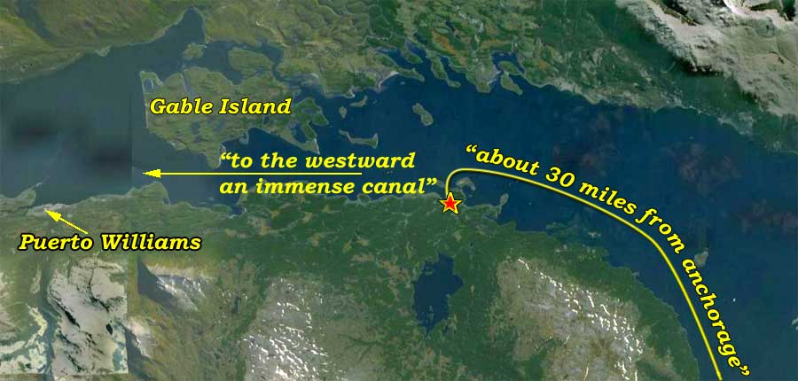
After passing some thirty miles from the Beagle anchorage at Goree Road, FitzRoy described their arrival at “Cutfinger Cove” which he had named “… because one of our party, Robinson by name, almost deprived himself of two fingers by an axe slipping with which he was cutting wood.”
January 19th, 1833. We … reached Cutfinger Cove. At this place, or rather from a hill above it, the view was striking. … to the westward we saw an immense canal, … almost straight and of nearly an uniform width for one hundred and twenty miles [The Beagle Channel].
And the next day, …
20th. We passed the clay cliffs [which] narrow the channel to less than a mile, …
For January 19th, Darwin writes that …
In the afternoon we entered the eastern mouth of the channel, and shortly afterwards found a snug little cove concealed by some surrounding islets.
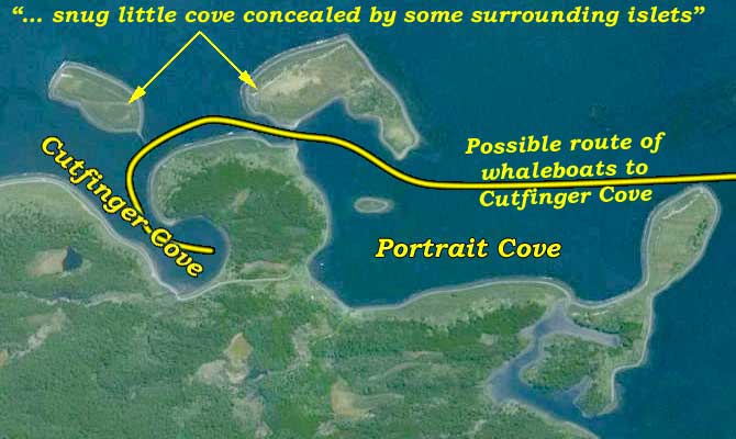
The Google Earth view below shows the northeastern segment of Navarin Island (now, Isla Navarino), with a location (star) that agrees with FitzRoy's description of Cutfinger Cove, and Darwin's “…snug little cove concealed by some surrounding islets.” FitzRoy's reference to cliffs that “…narrow the channel to less than a mile” agrees with the passage between Gable Island and the northern coast of Navarin Island.
Hover the mouse pointer over the magnifying-glass icon for a detail view of both Cutfinger Cove and Portrait Cove—the latter described below.

Portrait Cove
Neither FitzRoy nor Darwin mention the cove by name in their books. In fact, the only text reference is in the caption to the frontispiece illustration engraved by Thomas Landseer after three illustrations, two by Conrad Martens; the third from an unknown source, as seen here:
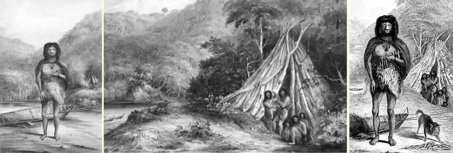
- Left: Conrad Martens: “[Fuegian] carrying a bag of coals [?] for lighting a fire” (K. 128),
- Center: Conrad Martens: “A Family Group. Entrance to the Beagle Channel” (K. 129),
- Right: Thomas Landseer: Frontispiece engraving, derived from Martens' drawings, with dog added from unknown source (possibly, Landseer himself).
Note: Titles for Martens drawings are from Richard Darwin Keynes' The Beagle Record. Number in parentheses is from the author's “Conrad Marten's ‘Beagle’ Pictures.” (p. 394). The frontispiece caption is:
Fuegian
(Yapoo Tekeenica)
at Portrait Cove
As to the location of Portrait Cove, again the best we have are some clues by FitzRoy. In his Chapter 15, he writes:
On the 27th, we crossed Nassau Bay to Goree Road, and the following day entered the Beagle Channel.
The 1st of March passed in replenishing our wood and water at a cove, where we had an opportunity of making acquaintance with some Yapoo Tekeenica natives, who seemed not to have met white men before.
In other words, the Beagle's first anchorage after Goree Road was slightly west of the eastern entrance to the Beagle Channel, at a place identified simply as “a cove.” In context, this suggests it is not the earlier Cutfinger Cove, else FitzRoy would have called it by that name on this visit. And since Martens was not aboard on their visit a year earlier, this would be his first meeting with these natives. These clues suggest that Cutfinger and Portrait Coves are not the same place, but that the latter is some other cove near Cutfinger Cove.
One possible reason that FitzRoy makes no mention of Portrait Cove by name is that this name was not his, but rather that of Landseer, who added it when he created the engraving. The Google Earth detail view above shows a likely location for Portrait Cove.
To introduce (and then, argue against) a conflicting view, the “Part of Tierra del Fuego” chart in FitzRoy's volume shows a “Portrait Cove” on the eastern coast of Navarin Island, well before the entrance to the Beagle Channel. But there are several reasons to assume this chart is in error:
- FitzRoy's own written description contradicts this placement,
- The “Portrait Cove” notation makes its first appearance on this chart, drawn by cartographers J. & C. Walker for FitzRoy's 1839 book,
- FitzRoy's original chart,* prepared several years earlier does not show any “Portrait Cove” notations,
- The original chart shows numerous soundings in the general area of the above Google Earth image, and none at all in the Portrait Cove area on the 1839 J. & C. Walker chart.
* “Part of Tierra del Fuego from HMS Beagle 1834. No. 27” showing Whaleboat Sound, Darwin Sound, Gordon and Navarin Islands (L295, Fs: Office Mark & Shelf at the United Kingdom Hydrographic Office, Taunton, UK).
These points are offered as further evidence that the Beagle spent some time near the eastern entrance to the Beagle Channel, and little or none along the east coast of Navarin Island. Thus, Martens had sufficient time at the former location, and none at all at the latter, to draw his illustrations.
And as a final clue, note that the Conrad Martens illustration (center, above) places the Fuegian group's location at “Entrance to the Beagle Channel.” As just noted, Portrait Cove on the Walker's chart is not at the channel entrance.
Bahía Windhond
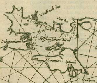
Johannes van Walbeek's “Suydfyde van tierra del Fuego… ” was the first chart to show Windhonds Bay on the southern coast of Tierra del Fuego's Isla Navarino. Based on the Dutch Nassau Fleet expedition of 1623, and highly inaccurate, the chart does show the bay at about 55° 30' south latitude, and 7.5 Dutch (approximately 22.5 English) miles to the northwest of “Lheremitens Eylandt.” (now, Isla Hermite, after Jacob l'Hermite, the expedition commander.) This is reasonably close to the actual latitude and distance to the modern Wollastan and Hermite Island groups. Also, there are two small unnamed islands near the bay entrance; presumably the modern Islas Bertrand and Scott.
The “Goe Ree” [Good Harbor, and the name of the Dutch port of Goree, from which they sailed] notation may refer either to the large bay to the right of the words, or to the general area along the southern shore of Isla Navarino. In any case, the former is, according to the chart, about 7 Dutch (21 English) miles east of Walbeek's Windhonds Bay. This is quite close to the actual distance between his Windhonds Bay (now, Seno Grandi) and the larger bay now known as Bahía Windhond, all of which are shown in the Walbeek detail view at right.
A few clues suggest that FitzRoy had seen Walbeek's chart:
- He places Walbeek's “Goe ree” on the roadstead along the east coast of the island, as “Goeree Road” (which later becomes “Goree Road”),
- His own Windhond Bay coordinates agree with Walbeek's positioning, as does his description that it is “… a deep place full of islets.” (p. 225, vol 2).
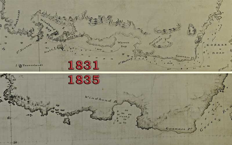
The location of Windhond Bay on the “Part of the Southern Coast of Tierra del Fuego” from the first voyage is shown at the top of the following illustration, which is marked with the year it was received by the Hydrographic Office. A scale at the top of the chart indicates that the vertical line passing through the bay is 3° 10' east of Port Famine, which is correct. A similar chart from the second voyage (with Darwin) is also shown, again marked with the year it was received by the Hydrographic Office.
| United Kingdom Hydrographic Office Identification for Charts Above | |||
|---|---|---|---|
| Office Mark | Shelf | Date Stamp | Title |
| H500 | Fq | 26 May 1831 | Chart of part of the Southern Coast of Tierra del Fuego Surveyed in H. M. Sloop Beagle 1829-30 |
| L295 | Fs | 6 Aug 1835 | No. 27 Part of Tierra del Fuego from HMS Beagle 1834 |
In comparing the charts, note a few significant changes:
- The Windhond Bay detail from the 1831 chart is gone,
- The Windhond Bay label has been moved to the bay previously identified as Warren Bay,
- The revised location contradicts FitzRoy's own coordinates in his Table of Positions.
In volume 1 of the Narrative, FitzRoy's May 5, 1830 entry offers evidence that the 1831 chart is correct, and the 1835 chart is not. In sailing westward, he passed through a kelp bed, continued past a low point of land and later saw guanacos feeding near Windhond Bay. The 1831 chart shows kelp notations on either side of Warren Bay, and therefore he was to the west of this bay when he approached the original Windhond Bay.
When the chart was redrawn (not shown here) for inclusion in FitzRoy's volume 2, the Windhond Bay label was returned to its location on the 1831 chart, and the larger bay to the east is now labeled Kelp Bay.
So far, no explanation for these changing details has been found, and in the intervening years since the voyages of the Beagle, Walbeek's location and FitzRoy's coordinates and description have been overlooked. The old Windhonds Bay is now Seno Grandi, and Bahía Windhond is now permanently associated with the large bay several miles to the east.