Narrative of the Surveying Voyages …

“Proceedings of the First Expedition, 1826-1830”

Phillip Parker King, Pringle Stokes, Robert FitzRoy

Bibliography
TABLE OF CONTENTS
  Information about the text on this page
 Preface & Introduction
I Departure from Monte Video
II Enter the Strait of Magalhaens
III Prepare the Beagle
IV Deer Seen—Hope Sails Again
V Lieutenant Sholl Arrives
VI Trees—Leave Port Famine
VII Leave Rio de Janeiro
VIII Find that the Cutter has been Burned
IX Detention in Port Gallant
X Account of the Beagle's Cruise
XI Leave Port Otway
XII Adventure Sails from Rio de Janeiro
XIII Beagle and Adelaide anchor in Possession Bay
XIV Place for a Settlement
XV Extracts from the Journals …
XVI Chilóe—Its probable Importance
XVII Chilóe the last Spanish Possession
XVIII Adelaide's Last Cruise
XIX Sarmiento Channel
XX Beagle Sails from San Carlos
XXI Skyring's Chart
XXII Mr. Murray Returns
XXIII Set Out in Boats
XXIV A Few Nautical Remarks … Cape Horn
 Appendix (not included)
Show FitzRoy's Proceedings … (vol. 2)
Show Darwin's Journal … (vol. 3) or
Voyage of the Beagle

CHAPTER XVIII

Adelaide's last cruise—Port Otway—San Quintin—Marine Islands—Unknown river or passage—San Tadeo—Isthmus of Ofqui—San Rafael—Sufferings and route of the Wager's party—Channel's Mouth—Byron—Cheap—Elliott—Hamilton—Campbell—Indian Cacique—Passage of the Desecho—Osorio—Xavier Island—Jesuit Sound—Kirke's report—Night tides—Guaianeco Islands—Site of the Wager's wreck—Bulkeley and Cummings—Speedwell Bay—Indigenous wild potato—Mesier Channel—Fatal Bay—Death of Mr. Millar—Fallos Channel—Lieutenant Skyring's illness—English Narrow—Fish—Wigwams—Indians—Level Bay—Brazo Ancho—Eyre Sound—Seal—Icebergs—Walker Bay—Nature of the country—Habits of the natives—Scarcity of population.

I will now relate the principal incidents of the Adelaide's last cruise. The following pages contain extracts from Lieutenant Skyring's journal, and also notices obtained from other sources.

The Adelaide sailed from Chilóe on the 8th of December 1829, made Cape Tres Montes on the 14th, and anchored in Port Otway the same evening. Of this place Lieutenant Skyring writes:

“Good anchorage, wood, water, and shell-fish (such as muscles and clams) Port Otway affords: but no more. Excepting in one or two sandy bights, a landing is hardly to be effected; walking along shore is impossible, and it is scarcely practicable to enter the country, the land being so thickly wooded, from the summits of the hills down to the water-side. No soil is to be discovered; the shrubs, and even the trees, which are of large growth, rise out of moss, or decomposed vegetable substances. The climate is very wet; none but amphibious animals were seen, among which hair-seals were numerous. There were very few birds, excepting turkey buzzards; and not a trace of human beings; indeed, I do not believe Indians ever go there—(y) they rarely leave the direct channels; as a proof of which, some articles left by the Beagle, in a conspicuous place, were found by us untouched.”

During the Adelaide's stay at Port Otway, the openings on the east side of Hoppner Sound were explored, yet they proved to be only small inlets. Mr. Kirke examined some, which appeared to communicate with San Quintin Sound; but found them to be merely channels dividing the group of the Marine Islands,* excepting the most southern, which is the entrance of Newman Inlet, a deep bight, without anchorage, but abounding with hair-seal.

(y) For evidence that Indians have been thereabouts, see Byron's account of the cave entered by the surgeon of the Wager. I believe that curious place was either in, or close to. Port Otway.—R.F.

* The Marine Islands were so called, in remembrance of the four marines who were put on shore from the Wager's boats, and left behind. See Byron's Nar., p. 85.

From Byron's Narrative it would appear, that there is a channel somewhere hereabouts communicating with the Gulf of San Rafael, to the east of the Peninsula of Tres Montes; for the Indian guide wanted to conduct the Wager's barge through it, but was prevented by the strength of the current.

The Adelaide sailed from Port Otway on the 18th, and the same evening reached San Quintin Sound, anchoring opposite an opening northward of Dead-tree Island, that proved to be the mouth of the River San Tadeo, by which Byron and his unfortunate companions effected their escape to Chilóe.

The sufferings of this party, which are so affectingly described in Byron's narrative of the loss of the Wager, made so deep an impression on our minds, that I thought it not irrelevant to the object of this voyage to endeavour to trace their steps. Among the numerous incidents that occurred to them, the passage of the ‘Desecho,’ or carrying-place over the Isthmus of Ofqui, is, from all the circumstances connected with it, one of the most interesting. It may be remembered, that, upon the departure of Captain Cheap, and his shipwrecked crew, from the place of the wreck (Byron's Narrative, p. 69), they proceeded round the shores of the Gulf of Peñas, with an intention of tracing the Coast of Chilóe. They first attempted to steer for Cape Tres Montes, which headland they had seen, in one of the intervals of fair weather, from the summit of Mount Misery, and which appeared to be twenty or thirty leagues distant. The wind, however, freshened to a gale, and they were obliged to run before it, and throw all their provisions overboard to lighten the boat.

At night they took refuge in a small opening, which led to a secure harbour, and next day advanced a little farther, till they reached some small islands, where they were detained three or four days by bad weather.

After leavmg that place, they found an opening, into which they rowed, flattering themselves it would prove to be a passage; but, being disappointed, they were obliged to return. This was probably the inlet, called ‘Channel's Mouth.’ Xavier Island was the next place they went to, named by them Montrose Island. Byron describes this island so exactly, that there cannot be the least doubt of its identity. “The next morning,” he says, “being calm, we rowed out; but as soon as clear of the island, we found a great swell from the westward: we rowed to the bottom of a very large bay, which was to northward of us, the land very low, and we were in hopes of finding some inlet through, but did not; so kept along shore to the westward. This part, which I take to be fifty leagues from Wager Island, is the very bottom of the large bay it lies in. Here was the only passage to be found, which (if we could by any means have got information of it) would have saved us much fruitless labour. Of this passage I shall have occasion to say more hereafter.”—Byron's Nar. p. 74. This is evidently San Quintin Sound. They proceeded to the westward and northward, entered a larger bay (Holloway Sound), and discovered another headland at a great distance to the westward (Cape Tres Montes), which they reached with much difficulty; but being unable to get round it, and losing the boat that accompanied them, besides being obliged to leave four of the marines behind, they became quite disheartened, and returned to Wager Island, to linger out their miserable lives, without the least prospect of again seeing home. This expedition occupied two months, during which they lived principally upon sea-weed, called ‘tangle;’ but sometimes passed whole days without eating anything at all. While they were absent, some Indians had visited the wreck; and, about a fortnight after their return, they arrived a second time, in two canoes. Among them was an Indian Cacique of the Chonos tribe, who live in the neighbourhood of Chilóe. It was supposed that a report of the wreck had reached that place; and that this Cacique, and another Indian, had come to derive some advantage from it. As the Cacique spoke Spanish, the surgeon, Mr. Elliot, made himself so far understood, as to let him know that they wished to reach some of the Spanish settlements; and eventually bargained to give him the barge, and every thing in it, if he would conduct them to Chilóe. The party consisted of Captain Cheap; Mr. Elliot, the surgeon; Mr. Campbell, Mr. Hamilton, and Mr. Byron, midshipmen; and eight men, besides the two Indians; in all fifteen. The first night they slept on an island, and the next laid upon their oars, to the westward of Montrose Island, not being able to land.

They then pulled, “to the bottom of a great bay, where the Indian guide had left his family, a wife and two children.” There they staid two or three days; after which, taking on board the family, they proceeded to a river, “the stream of which,” Byron says, “was so rapid, that after our utmost efforts, from morning to evening, we gained little upon the current; and, at last, were obliged to desist from our attempts, and return.”

This was probably a river, or channel, to the westward of San Quintin Sound, which eluded our search; and, if so, it must communicate with channels north-eastward of the Peninsula of Tres Montes. The Indians, anxious to get the barge to the Chonos, had no other way to effect their purpose; for the usual route was over the ‘Desecho;’ to pass which, it was necessary to take a boat or canoe to pieces, and carry her, piecemeal, over a high mountain.

After losing the barge, they crossed the Peninsula of Forelius, by hauling canoes over a narrow neck of land, and reached the water of San Quintin Sound; where they met another native family, with whom they proceeded to the River San Tadeo, “up which they rowed four or five leagues; and then took to a branch of it that ran first to the eastward, and then to the northward.” There they landed, took the canoes to pieces, and carried them over the isthmus; then putting them together again, re-embarked, and proceeded through the Chonos Archipelago to Chilóe.

When at Chilóe, I saw an old man, Pedro Osorio, who had been in two of the last missionary voyages (in 1769 and 1778), to the Guaineco Islands; where the Wager was wrecked. He related to me the particulars of these voyages, and gave me an account of the ‘Desecho,’ over which the missionaries transported their piraguas. He also remembered Byron and his companions; and described them by the following names:—Don David (Captain David Cheap): Don Juan (John Byron); Hamerton (Hamilton); and Plasta. The name Plasta is not once mentioned in Byron's Narrative; but on referring to Bulkeley's and Cumming's account, one Plastow is described as the captain's servant; and perhaps he was one of the number who remained with Captain Cheap.(z) Pedro Osorio must have been upwards of ninety years of age, in 1829.(a) A detailed account of these voyages is given in Agüeros's Historical Description of the province of Chilóe, p. 205.

(z) Could ‘Plasta’ refer to Alexander Campbell?— R. F,

(a) Pedro Osorio died at San Carlos in 1832.—R.F.

Captain Stokes's ‘Dead-tree Island,’ in the entrance of San Estevan Gulf, is near the ‘Cirujano Island’ (Surgeon Island) of those voyages. Pedro Osorio told me that it was so called, because the surgeon of the Wager died there. From Byron's Narrative it would appear, that the surgeon died, and was buried, just before they embarked to cross the sound.—See Byron, p. 147.

As the examination of the River San Tadeo, and the discovery of the ‘Desecho,’formed a part of Lieutenant Skyring's instructions, he proceeded up it, in a whale-boat, accompanied by Mr. Kirke, The entrance of the river is blocked up by a bar of sand and stones, which, at low spring-tide, must be nearly dry; and a heavy swell breaks upon its whole length, joining the surf of the beach, on each side; so that there is no deep channel; and, except in very fine weather, an attempt to cross is hazardous.

At its mouth, the breadth is about a quarter of a mile, but within the entrance it increases for a short distance: at three miles up, it is three hundred yards, and thence gradually diminishes. The shores are a mixture of clay and sand; and the country, on both sides, is low and marshy, abounding with brant-geese, ducks, teal, and snipe.

The land, near the mouth of the river, is studded with dead trees (a species of pine, about twenty feet high), which appear to have been killed by the sea overflowing the banks; (b) as it does at high-water for several miles.

(b) Or by an earthquake wave.—R.F.

Three miles from the entrance this river divides into two branches, one leading N.W., and the other eastward. Considering the latter, from Byron's description, to be the proper course, Lieutenant Skyring followed it. At nine miles from the mouth, a stream was found falling into the river from the north, in every respect differing from the principal stream; the water being fresh, dark, and clear, and the current constantly running down, uninfluenced by the tide; while the water of the river was brackish and turbid, and affected by the ebbing and flowing of the tide, although, at that distance, its effect was much diminished.

The shores of the Black River, as this new stream was called, are thickly wooded, which is not the case with the principal stream. They had entered it about a hundred yards before they discovered that they had left the main river; but being desirous of proceeding, they followed its windings, the next day, for three leagues; during the greater part of which distance, they found a strong current against them, and were also much impeded by fallen trees lying in the bed of the river. In many parts they dragged their boat along by the help of overhanging branches, or projecting roots; and the width, generally, was not more than fifty yards. As no piragua could pass there. Lieutenant Skyring felt assured that he was not in the right stream; therefore, returning to the main river, he proceeded up it during the next two days. At two miles above the junction, the tide ceased to be felt; and a rapid current met them, which increased in strength until they were unable to stem it; and as they were prevented from tracking the boats, by trees growing on the banks, they could ascend no farther.

This place was not more than eleven miles from the sea; although, from the tortuous course of the stream, they had gone double that distance, and were about two miles from the foot of a mountain, whence the river descends. The mountain was very high, and the vallies, or ravines, were filled with glaciers. From Byron's description, it seems probable that Lieutenant Skyring was near the carrying place; but as further delay could answer no good end, he very prudently returned, looking carefully about, as he proceeded, for some signs of a landing place, but without success. He re-crossed the bar, reached the Adelaide without accident, and the next day went on in her to Xavier Island. On the way they passed Dead-tree Island; where, observing seal on the rocks, a boat was sent ashore, and her crew succeeded in killing a few sea-elephants, twenty feet long.

Favoured with fine weather, they were enabled to land on the north side of Xavier Island, to improve the former survey; and in the evening anchored in Xavier Bav, where they remained four days; during which, Jesuit Sound was explored, and found to terminate in two narrow inlets. Being a leewardly opening, it is unfit for any vessel to enter.

The name Jesuit Sound, and those of the two inlets at the bottom, Benito and Julian, are memorials of the missionaries, who, in the expedition of 1778, entered and explored it.* (Agüeros, p. 232.)

* Mr. Kirke, who examined them, says, “There are two openings opposite Xavier Island, on the main land: the northernmost runs through liigh land, and is terminated by a low sandy beach, with a river in the middle, running from a large glacier; the southern inlet is ended by high mountainous land.”

The Adelaide anchored the next night in Ygnacio Bay, at the south end of Xavier Island, which Lieutenant Skyring recommends for small vessels; the depth of water being six or eight fathoms, and the anchorage well sheltered from the wind. On the 31st they anchored under the Hazard Islands, in the Channel's Mouth: "“preparatory,” writes Lieutenant Skyring, “to commencing new work with the new year; for since entering the gulf, except while examining the San Tadeo, we had followed the Beagle's track, and only completed what she left unfinished; but from this place all would be new. This was the last wild anchorage she had taken; and although now fixed in the best situation, and in the height of summer, we found our position almost as dangerous as hers.

“Early on the 1st of January 1830, Mr. Kirke went in a whale-boat to examine the openings, at the mouth of which we had anchored: he returned on the 9th, having traced to the end, all which had the least appearance of being channels. The two largest, the south and the east, penetrated into the Cordillera for thirty miles. All these inlets are narrow but deep arms of the sea, running between ranges of very steep hills; their sides affording not the least shelter, even for a boat, and apparently deserted; for neither seal, nor birds of any kind were seen, nor were there even muscles on the rocks.”

Mr. Kirke, in his report, says: “The three northernmost of the inlets of the Channel's Mouth end with high land on each side, and low sandy beaches at the head, beyond which there rises a ridge of high mountains, about two miles from the beach. The S.E. inlets end in rivers rushing down from the mountains, and a rocky shore: not the smallest shelter could I find, even for the boat. Two days and nights I was forced to keep her hauled up on a rock, just above high-water mark, in a strong gale, while the williwaws were so violent, that we were all obliged to add our weight to that of the boat, to prevent her from being blown off: and twice we were washed out of our resting-places, on the beach, by the night tide rising about fifteen or sixteen inches above that of the day.”

This opening in the coast is noticed by the pilot Machado (Agüeros, p. 210); but by whom the name of Channel's Mouth was given, does not appear. It is by no means descriptive of what it has been proved to be; but as Lieutenant Skyring thought that a change in the name would not answer any good purpose, he very properly left it unaltered.

The day after Mr. Kirke returned, very bad weather set in, and detained the Adelaide nine days, during which nothing could be done, out of the vessel.

Lieutenant Skyring writes,—

“January l0th. With moderate weather, and an easterly wind, we left the Channel's Mouth, and, standing for the Guaianeco Islands, passed those of Ayautau (between which and the mainland are several rocky reefs, though the passage seems to be sufficiently clear for any vessel); and skirting Tarn Bay, we distinguished the Mesier Channel, and could see many leagues down it. The entrance of the Mesier Channel is very remarkable, from having two high and singular peaks on the islands at its mouth: the northernmost very much resembling (although higher than) Nelson's monument, near the Strait; and the other, more to the southward, and much higher, resembling a church with a cupola, instead of a spire. Both are easily made out from the westward, at a distance of twenty or thirty miles.

“We reached the Guaianeco Islands in the afternoon. The two largest are divided by a narrow passage, on the west side of which we anchored, in ten fathoms, in a spacious and secure haven, which proved to be Speedwell Bay of Bulkeley and Cummings; the boats were employed next day, and, while the examination of the coast was pursued, I sought to ascertain the exact spot of the wreck of the Wager, but never could discover it: not a fragment of that ill-fated vessel was seen in any of our excursions. A few pieces of the boat lost by the Beagle last year were picked up; but nothing more that could tend to denote the misfortunes which have occurred near these islands.

“From the description of the Wager's wreck, in Bulkeley and Cummings, there seems to be little doubt of the place being at the N.W. end of the eastern Guaianeco Island, near my Bundle's Passage, which is the place so often mentioned in their account as the ‘Lagoon.’

“Being well supplied with powder and small shot, the people provided themselves plentifully, during our stay at Speedwell Bay, with a variety of wild-fowl, namely, geese, ducks, redbeaks, shags, and the ibis; curlew, snipe, plover, and moorhens, were also met with, and fish were observed in shoals near the vessel, but, as we had no seine, they escaped. With hooks and lines our fishermen had no luck; the baits were no sooner at the bottom, than they were taken away, and for a day or two the cause of their loss was unknown; but being accidentally ascertained, small trap-nets were made, and great numbers of crabs were taken, about a pound each in weight.

“In almost every bay we noticed the potato, growing among wild celery, close above high-water mark: but in so unfavourable a situation, choked by other vegetables, its produce was very small.

“The trees are not of large growth in these islands, neither is the land thickly wooded; but above the beach, and almost round the coast, there is a breastwork of jungle and underwood, from fifty to one hundred yards broad, and nearly impenetrable; beyond which is a great extent of clear, but low and swampy ground.

“On the 25th, we left this port, and ran to the S.E., through what I have named Rundle's Passage. This small channel, where the islands approach each other, is about a quarter of a mile wide, perfectly clear in the whole extent, and also at its southern entrance; but at the northern there are many detached rocks, which are obstacles to entering Speedwell Bay, except in daylight. Rounding the islets, at the S.E. extreme of Byron Islands, we anchored in Muscle Bay, which lies on the northern side: by no means a secure place,—but the only one that could be found, by the boats, after many hours' search. I selected this situation in order that the entrance to the Fallos Channel, and the whole outline of these islands, might be laid down, and properly connected with the land of Port Barbara; which was thoroughly executed by Mr. Kirke and Mr. Millar, although delayed in the completion of their work until the 1st of February.(c) On that day we sailed, and entered the Mesier Channel, anchoring in a small open bay, the only stopping-place we could perceive; which, from the loss we sustained shortly after our arrival, was called Fatal Bay. It is insecure, and the anchorage ground confined: the only convenience was, that wood and fresh-water were near. During our stay we had much rain, which retarded us. Mr. Kirke went away in a boat, whenever the weather permitted, and, on the 8th, we sailed for an anchorage, about ten miles to the southward, where he had previously been; but a sad event happened before our departure.

(c) During much of this cruise, Lieutenant Skyring was so ill that he was unable to leave the Adelaide; and for a month he was confined to bed. His illness was caused by fatigue, and by sitting too long while constructing charts.—R.F.

“On the afternoon of the 3d, we had the misfortune to lose Mr. Alexander Millar, who died in consequence of a severe attack of inflammation of the bowels, which carried him off, after an illness of only three days.

“On Thursday afternoon he was buried, close to the shore, near the anchorage, and just within the edge of the wood.

“That our progress had been so slow during the last month, was a great disappointment; but we had had many causes of detention. All the early part of January the weather was stormy: eighteen days we were anchored within the Channel's Mouth; yet during two only could our boats leave the vessel.

“Among the Guaianeco islands we had moderate weather, but also much wet: still the chief cause of our delay, I fear, was my own illness. From the beginning of January, I had been confined to my bed, with a tedious and obstinate disease; and from that time most of the angles were taken, and all the observations were made, by Mr. Kirke, who was ever exceedingly willing and indefatigable. After the loss of Mr. Millar, not only almost the whole duty of surveying fell upon him, but much of the duty of the vessel.

“At noon this day (8th), we moored in Island Harbour, a small but excellent landlocked anchorage, with good holding ground, and abundance of wood and water. The two following days, Mr, Kirke was away examining the coast; the third we were confined by bad weather; and, indeed, during our whole continuance at this place, we had very much rain.

“We sailed early on the 12th from Island Harbour, and by night reached Waterfall Bay, an anchorage about fifteen miles to the southward: the wind all day was light, and the tide, the greater part of the time, against us; so that, with every exertion, we scarcely gained anchoring ground before it was quite dark: the strength of the tide was upwards of a mile an hour, at neap-tides: the ebb and flood were of equal duration, the former running to the S.b.E., the latter N.b.W. Thirty miles within the Mesier Channel it is as wide as at the entrance, and for several miles to the southward appears clear: so that no one is liable thus far to mistake its course.

“The land on the west side appears to be a number of large islands, with here and there wide passages leading to the S. W., rendering it probable that there are many (although not direct) communications between the Mesier and the Fallos Channels. Our anchorages were chiefly on the eastern shore, that the openings on that side might be more readily examined; but all which appeared to run far inland were found to be merely narrow inlets, or sounds ending abruptly. On each side the land is hilly, but not high; and this distinguishes the Mesier Channel from many others, whose shores for miles are formed by ranges of steep-sided mountains. Here, in many places, there is much low land, which is generally thickly wooded, yet with no greater variety of trees than is to met with in the Strait of Magalhaens. The beech, birch, pine, or cypress, Winter's-bark, and a kind of red-wood, form the forests; but none were observed that could be at all serviceable for the larger spars of a vessel.

“(16th). Left Waterfall Bay, and with a N.W. breeze passed Middle Island, entered Lion Bay, and moored in White Kelp Cove. The coast survey was soon finished, but we were confined at our anchors here four days; not by bad, but by extraordinarily fine weather. During such intervals, so very rare in these regions, the wind, if there is any, is almost always southerly, and light.

“At every anchorage we had found Indian wigwams, but as yet had not met with any natives. Here we took a great number of fish; and, among them, one like the ling, found on the east coast of Patagonia, off Cape Fairweather, but of smaller size, for the largest did not weigh more than two pounds. Very few water-fowl were seen; steamers and shags were the only ones shot; but in the woods we noticed king-fishers, woodpeckers, barking-birds, parroquets, and humming-birds.

“(21st.) With a light northerly wind we left this cove, and about ten miles to the southward the appearance of the channel changed greatly. Instead of sailing through unconnected land, of moderate height, we were confined between two mountainous ridges.* At noon we were obliged to anchor in Halt Bay, no opening appearing to the right or left, and being apparently embayed. On the west side, the high land was skirted by several low islands, among which our only way of proceeding seemed to lie. This day and the next Mr. Kirke was away, seeking a passage; and having found one, and noticed the tides, we sailed through on the 23d, and gave it the name of the English Narrow. It is long and intricate, chiefly formed by islands; and in three places, where the shores approach each other, the distance across is less than four hundred yards, yet with a fair wind and slack tide, there is no hazard in passing. In the afternoon, we moored in ten or twelve fathoms in Level Bay, a spacious anchorage near the southern entrance of the Narrow; the bottom mud and sand, and the depth of water equal throughout. Mr. Kirke, who was among the islands opposite this bay, saw numerous shoals of fish in many of the bights; with a seine, therefore, an abundant supply might be obtained.

* On the west shore Mr. Kirke noticed what appeared to be a channel, about twelve miles N. W. of Halt Bay, in the mouth of which was a considerable tide-ripple; an almost certain indication of such an opening. “I thought the inlet about twelve miles north-west of Halt Bay much like a channel. I also noticed a distinct tide ripple, which I did not remark near any other opening. To me this appeared the southernmost inlet, of any depth; or at all likely to be a channel.”—Kirke MS.

“The woodland eastward of our anchorage had very recently been on fire, and the conflagration must have been extensive, and very destructive; for throughout a space of ten or twelve miles along shore, all the trees had been consumed, the dead trunks of the larger ones alone remaining. We left Level Bay on the morning of the 25th, and passed a canoe full of Indians; but they pulled to the shore, and ran into the woods; therefore, since they avoided us, and we had a fair wind, I did not seek their acquaintance. We had noticed traces of them in the neighbourhood of the Narrow, on each side of which many wigwams, that had been recently occupied, were seen.

“For the next ten or twelve miles we went through a fine reach, whose shores were low, and whose channel was interspersed with several islands, affording probably excellent anchorages; but to the southward the hills became more steep, and, except in the ravines, were destitute of vegetation. At four or five leagues to the E.S.E., beyond the English Narrow, an opening, apparently a channel, presented itself, and the reach in which we were sailing seemed to end. Doubtful which course to follow, we anchored the vessel in Rocky Bight, and despatched the boats to examine both passages. That to the E.S.E. was found to run direct nearly ten miles, and to communicate with a fine clear channel, trending to the S.S.W., which proved afterwards to be the Wide Channel (Brazo Ancho) of Sarmiento. At the junction, a considerable arm extended to the N.N.E., apparently a continuation of the Wide Channel.

“On Mr. Kirke's return from examining the passage in which we were sailing, I learnt that the same width continued about five miles southward of our present anchorage, and that there the shores approached closely, forming the intricate passage called Rowlett Narrow; which, after a S.E. course of many miles, also joins Wide Channel. The island formed by the two channels was named Saumarez Island, in honour of the gallant admiral.

“It rained hard and blew strongly, the whole day, which prevented our moving; but on the 27th we shifted our anchorage to Fury Cove, in Wide Channel.

“Mr. Kirke, on the 28th, examined an opening to the northward, called Sir George Eyre Sound, which terminates in a wide freshwater river, running through low land from a large glacier. The low grounds extend two or three miles from it, and then the land becomes high. Behind the glacier there is a ridge of high mountains, covered with snow, which we had seen twice before; first, from near White Kelp Cove, and again from Halt Bay. In the sound, we saw three whales, and being the first we had observed, since leaving the Gulf of Peñas, they inclined us to think we were near the Gulf of Trinidad. A great number of fur seal, besides two of their rookeries, or breeding-places, were also seen. Several icebergs were floating out of the sound, some of which were darkcoloured; and upon one I found a quantity of rock that had come down with it from the mountains. There was serpentine and granite, specimens of which were collected, and given to Captain King. One of the bergs, which was large, was aground. It was nearly seven fathoms above the water, and bottom could not be found by sounding round it with twenty-one fathoms of line.

“Fury Cove is diminutive; there is not more than sufficient space for two small vessels; but the ground is good, and in every other respect it is a secure haven. We sailed on the 3d of March with the expectation of soon recognizing some known points in the Gulf of Trinidad; but as the wind failed, we were obliged to anchor for the night in Sandy Bay, in eight fathoms.

“As we proceeded to the southward, the appearance of the country gradually changed: the mountains seemed more barren, the trees and shrubs more stunted, the land rose more suddenly, and the shores of the channel became bolder, and presented an uniform rocky line of coast.

“(4th.) We again steered southward, and at noon an opening appearing on the east side, which ran several miles inland, I sought an adjacent anchorage, in order that it might be explored. Our boats were examining the shore all day, and sounding in the coves, but no fit spot was found; therefore we were forced to stop in an ill-sheltered nook, termed Small Craft Bight, which just served us (having fair weather) as a resting-place until morning (5th), when we set out again to find a better anchorage; for I still desired to ascertain whether the opening to the eastward was a sound or a channel. In our course to the southward we traced both shores in search of a stopping place; but there was neither bight nor cove where it was possible to anchor, until we arrived at Open Bay, which lies near the entrance of Wide Channel. Even this was such a very insecure place, that although I remained the next day, to examine the neighbouring coast, it was far too exposed an anchorage for the vessel to continue in while the boats were away at a distance.

“Disappointed by not finding a place for the schooner near the opening I wished to explore, I was yet averse to leaving it unexamined, having traced every inlet to its extremity for upwards of two hundred miles along the continent. I wished to continue so sure a mode of proceeding; and although I felt certain that this opening terminated like the rest, and Mr. Kirke held the same opinion, I would gladly have prevented any doubt by following its course in the boats, could we have gained a safe anchorage for the vessel. The nearest harbour that could be found was thirty miles from the opening, and it would have detained us too long to send the boats such a distance; so considering that we had yet a great extent of coast to examine; that my state of health did not permit me to undertake any very exposed or arduous service; and that Mr. Kirke was the only person to whom such duty could be entrusted, I was induced to relinquish our former practice of exploring every opening to its end.

“We left Open Bay on the 7th, and soon entered Concepcion Strait, keeping along the east shore, and sending a boat, at every opening, to seek a situation for the vessel. In the afternoon, a tolerably sheltered bay was found, at the south end of the North Canning Island, open only from S.E. to S.W.; but those winds being frequent and violent, and the bay exposed to a long reach of sea from that quarter, it cannot be accounted a safe harbour; yet it was very far preferable to many places in which we had been obliged to anchor.

“This bay (Portland Bay) is on the north side of an opening called by Sarmiento ‘Canal de Tres Cerros,’ and from the broken state of the interior high land, one is led to imagine a channel might be found there. His conclusion, I have no doubt, was drawn from this appearance, since the view down the opening is very limited, and, at the distance of three or four miles within the entrance, is interrupted by several small islands. Mr. Kirke passed between those islets, and followed an opening to the S.E., for upwards of eight leagues. On his return, he reported that he had found a fine channel, of which the principal entrance was the opening of Sarmiento's ‘Canal San Andres.’

“On the 12th, in full anticipation of making some interesting discovery, we sailed into the ‘Canal San Andres,’ anchoring in the afternoon in Expectation Bay, where we remained until the 15th. During that time, Mr. Kirke was employed examining the different openings, and tracing this supposed channel farther. At his return, he said that he had found a termination to every opening, even to that in which we then were, which he had previously thought to be a channel. Like the rest, it extended only to the base of the snowy Cordillera, and then was suddenly closed by immense glaciers.

“This information caused great disappointment, as all hope of passing through the Cordillera, thus far northward, was now given up; and I was fearful we should be delayed many more days before we could extricate ourselves from this (as we then supposed) false channel. We were many miles within the entrance; in that distance there were no anchorages, and the wind being generally from the westward, I anticipated much labour before we could effect our return; but the very next day we were so fortunate as to have a slant of fair wind, by which we cleared this opening, and a second time entered Concepcion Strait. Knowing, by our former survey, that there was no anchorage along the coast to the southward of Cape San Andres before reaching Guard Bay, I ran over to Madre de Dios, and brought up in Walker Bay. Fortunate we were, too; for before midnight the weather became so stormy as to oblige us to strike the topmasts and yard, let go a second anchor, and veer a long scope of cable. At few places in these channels where we had anchored, could we have veered even half a cable. We remained the following day, and on the 21st, the weather being moderate, ran for the Guia Narrow, and having a favourable tide, passed through easily.

“It was my wish to have anchored among the islands to the southward of Cape Charles, since that would have been the most convenient place for the Adelaide, while examining the opening beyond Cape San Antonio; but hauling round the headland into a bay formed by those islands, no soundings could be gained; and not perceiving any bight at all likely to afford shelter, I continued my course for Puerto Bueno, where Sarmiento thought there was good anchorage. In the evening, with the assistance of the boats, we moored in Schooner Cove, Puerto Bueno, and the next day, Mr. Kirke went to examine the opening north of San Antonio.

“While we remained, a plan was made of this port, which lies five miles S.E. from Cape Charles and three and a-half from Bonduca Island. The shore is steep, and without any indenture. To the southward is Lear Bay, a mile in extent, affording anchorage, but not to be chosen when such an excellent haven as Puerto Bueno is near. The south extreme of this bay forms the north point of Puerto Bueno, and a few hundred yards south of that point is Rosamond Island, which is low and pointed; four hundred yards S.S.E. of this, is a small round islet, bold to on every side; and between this islet and a low point, a quarter of a mile to the S.E., is the widest channel to the anchorage. Sarmiento, indeed, most appropriately named it Puerto Bueno. It has both an inner and an outer port, the depth of water throughout is from nine to six fathoms, and any position in either I consider safe; but excepting that it affords better shelter, it differs in no respect from other anchorages in these regions. Wood and water are generally found in abundance near them all; fish may be caught; geese, ducks, shags, and steamers may be shot; and shell-fish gathered. The country, also, has the same appearance, and is of a similar nature; for if you force a passage through the woods, it is over fallen trees and moss; if you walk over clear flat ground, the place is found to be a swamp; and if you ascend the hills, it is by climbing over rocks, partially covered with spongy moss.

“Mr. Kirke returned on the 24th, having found that the opening beyond San Antonio led to the N.E., and at ten miles from the cape communicated with that called the Canal San Andres.

“At daylight we left Schooner Cove, and in passing down Sarmiento Channel I tried, though unsuccessfully, to reconcile some of his remarks with our own observations. South of San Marco and San Lucas there are two extensive bays, which we afterwards found communicated with an opening between San Mateo and San Vicente, separating the greater part of the eastern shore of this channel from the main land.

“I wished to anchor near Cape San Lucas, but around that opening no place could be distinguished likely to afford shelter, the shore in every part being bold, steep, and rocky. A like uniformity of coast presented itself as far as Cape San Mateo; but on the west side, along both Esperanza and Vancouver Island, lie many bays that are well adapted for vessels. Sailing, however, under Cape San Lucas, we stood for San Mateo, and succeeded in anchoring in a small port, formed by Weasel Island, scarcely large enough, but perfectly safe, when once Awe were secured. From this place the boats were despatched. An opening east of our present station was to be traced, and this part of Sarmiento Channel, with the entrance between San Mateo and San Vicente, was to be laid down. These operations, which in moderately fair weather would not have occupied three days, were not completed before the 31st, from our being delayed by violent winds, and almost continual rain. We had also had exceedingly bad weather during our stay in Puerto Bueno, and those employed in the boats had undergone very severe fatigue, and had suffered much from wet and cold. A short distance within the entrance of the opening, between Cape San Mateo and San Vincent, it turns suddenly to the south and S.b.E., continues in that direction for nearly thirty miles, washing the base of the Cordillera which rises from it precipitously, and is closed by a low isthmus, two miles across, dividing this inlet from Stewart Bay, and over which Mr. Kirke passed to take the bearings of several points that he recognised in Collingwood Strait.

“In the prosecution of the survey northward of our anchorage, those passages were discovered which separate so much of the east coast of Sarmiento Channel from the main land; and the islands thus made known I named after Commodore Sir Edward Owen,* the channel of separation being called Blanche Passage.

* At the request of Lieutenant Mitchell, of the Adventure.

“One of the boats met with a canoe containing eight Indians; this was only the second that had yet been seen during our cruise.

“An interview, which two of the schooner's men had with these people, is so characteristic of the habits of the natives who wander in canoes, that I add the account, as given by one of those men; ‘When we arrived at the wigwam, there were two women and five children inside, and a dozen dogs near it. At our entrance, the children crept close to one side of the wigwam, behind their mothers, who made signs for us to sit down on the opposite side, which we did. The women, seeing that we were wet, and meant to do them no harm, sent the two eldest children out to gather sticks, and made up a large fire; so we cut some pieces of bread from a loaf which we had, and distributed them. They all appeared to like the bread, particularly the youngest, which was sucking at the breast; for it eat [ate} its own slice, besides one we gave its mother. After we had been there about half an hour, and had given them some beads and buttons, a man came in from behind the wigwam, where he had concealed himself when we entered, and sat down beside us. By signs, he asked where our boat was, and how many men there were with us. We told him the men and boat were a little way off, and made signs that we wanted to stay all night with him. We then gave him some bread, which he smelt, and afterwards eat [ate]. He offered us some sea-elephant blubber, about two inches and a-half thick; we took it, and making signs it was not good, flung it on the fire. As soon as it began to melt, he took it from the fire, put one part in his mouth, and holding the other drew it back again, squeezing out the oil with his teeth, which were nearly shut. He put the same piece on the fire again, and, after an addition to it, too offensive to mention, again sucked it. Several more pieces were served the same way, and the women and children partook of them. They drank large draughts of water as soon as they had done eating. As it grew dark at about eight o'clock, the man began to talk to the women about our ‘sherroo’ or boat, and our men, who he thought were near. They seemed to be alarmed, for the women shortly after left the wigwam, and did not return. They were quite naked. The man took the youngest child in his arms, squatted down with the rest, and making signs that he was going to sleep, stretched himself by the fire, the children lying between him and the side of the wigwam. Soon afterwards another man came in, who seemed to be about twenty-two years of age, younger by ten years than the first we saw. He had a piece of platted grass round his head, in the form of a band. After talking some time with his companion, he talked and laughed with us, ate some bread, and would have eaten all we had, if we had not kept it from him. He ate about two pounds of blubber, broiling and squeezing it, as the other had done, and drank three or four pints of water. We had only one case knife, which he was very fond of borrowing now and then, to cut the blubber, pretending that the muscle shells, which he broke for the purpose, were not sharp enough. He examined all our clothes, felt our limbs and breasts, and would have taken our clothes off, if we had let him. He wanted a knife, and was continually feeling about us for one, as we did not let him know that we had only one. He opened a rush basket, and took out several trifles, such as fire-stone,* feathers, spear-heads, a sailor's old mitten, part of a Guernsey-frock, and other things, some of which he offered for the knife.

* Iron pyrites.

“About midnight it rained very hard, and the inside of the wigwam became soaked with wet; so they all roused up, and made a large fire; then ate some blubber, and drank some more water. They always carried a firebrand with them when they went out in the dark to get water, or for any thing else they might want. When they had well warmed themselves they lay down again. The young man lay close to us, and, when he supposed we were asleep, began to search the man who had the knife, but we kept watch and he could not get it. About two hours afterwards he made up the fire, and went out, as we thought, for firewood: but for no other purpose than to take away bushes from the side of the wigwam, that he might have a clear passage for what he intended to do. Returning, he took up a piece of blubber, and asked for the knife to cut it. As soon as he had cut a slice, and put it on the fire, he darted through the part of the wigwam, which he had weakened, like an arrow. The other man seemed to be very much vexed, and thinking, perhaps, that we should do some mischief in consequence of the loss of the knife, watched an opportunity, when he thought we were asleep, to take out all the children, and leave us quite by ourselves. About two hours after, he returned, and pulling down dry branches, from the inside of the wigwam, made up a large fire. We had no doubt that the younger man was at hand watching us, and just at daybreak, as we were preparing to start, he jumped into the wigwam with his face streaked almost all over with black, and pretended to be quite a stranger. When we asked for the knife, he would not know what we meant, but took up one of our shoes that lay on the ground, and gave it to us. The band of grass was taken off his head, and his hair was quite loose. There were neither skins, spears, nor arrows in the wigwam, but no doubt they were in the bushes; for when we threatened to take the canoe he jumped into the wood, resting on one knee, with his right hand on the ground, and eyed us sharply till we were out of sight.”

“The other family seen in the Mesier Channel we did not communicate with, and it may be remarked that in this passage, although between four and five hundred miles in extent, we did not meet twenty human beings; a strong evidence that these regions are very thinly inhabited, particularly when it is considered that we made no rapid progress, and that our boats traversed, through different channels, at least twice the distance run by the vessel.”


CHAPTER XIX

Sarmiento Channel—Ancon sin Salida—Cape Earnest—Canal of the Mountains—Termination of the Andes—Kirke Narrow—Easter Bay—Disappointment Bay—Obstruction Sound—Last Hope Inlet—Swans—Coots—Deer—River—Lagoon—Singular eddies—Passage of the Narrow—Arrival at Port Famine—Zoological remarks.

“(April 1st). This morning the weather was very unsettled, squally, and thick: but as no delay could be admitted, when there was a possibility of moving, we left at eight o'clock, and followed the course of Sarmiento Channel. I have no doubt that a passage exists eastward of Point San Gaspar, leading to Collingwood Strait, and forming an island between that point and Cape San Bartolome: but with the N.W. wind and bad weather we then had, that bight was too leewardly for us to venture into.

“The knowledge of an opening there could be of no great importance, yet had I been able to find an anchorage near Cape San Bartolome I would gladly have profited by it, in order to assure myself of the existence of a passage. In hauling round, the appearance of the land favoured my impression; but our chief object being to seek a channel through the high mountains, I stood toward Stewart Bay, the most southern part examined by the boats. Finding I could not anchor there without entering the bight and risking delay, which I was unwilling to do, as I wished to reach Whale-boat Bay as soon as possible, we proceeded and anchored in the evening in Shingle Roads, ready for moving the next morning. Having, last year, passed along the whole line of coast, from Cape Earnest to this place, there seemed to me no necessity for a closer examination, for I knew there was no opening within that distance, and I could very little improve what was then laid down on the chart. The weather was very unpromising, and at daylight the next morning it blew hard from the N. W., but we weiglied and ran to the southward. When in the ‘Ancon sin Salida’ of Sarmiento the wind suddenly shifted to the S.E., and was so strong that we were quite unable to beat between Cape Earnest and the northern island of the ‘Ancon,’ but passing round, found anchorage near the east end in a small bay: however, as the wind had moderated, and the Canal of the Mountains was open to us, on the east side of which there appeared to be several secure bays, we kept under sail, and in the evening anchored in Leeward Bay, which we at first thought would afford excellent shelter, but on reaching it found we had erred exceedingly. There was no time to look for another, so we moored, and prepared for bad weather, which, as usual, was soon experienced; and we were kept two days without a possibility of moving, or doing any thing to make our situation more secure. We had heavy squalls during the whole time; the wind being generally west or W.N.W., but at times nearly S.W., when more swell was thrown into the bay.

“On the 5th we got clear of this bad and leewardly anchorage, the wind being more to the N.W.; but we had still such very squally weather, with rain, that it was a work of several hours to beat to Whale-boat Bay, where we moored in the evening, and prepared for examining the coast with our boats, both to the east and west. Before leaving Leeward Bay, a round of angles was taken from high ground north of the anchorage, and it was satisfactory to reflect that the ‘Ancon sin Salida’ was traced far more correctly than could be done in our former visit. There was constant rain and squally weather all the morning, and only in the latter part of the day could any work be performed in the boats. On the following morning Mr. Kirke went to trace the Canal of the Mountains, and I rejoice to say that I was again able to assist in the boat service, and went to examine some openings. After leaving Kirke Narrow on the right hand a wide sound appeared, about nine miles in length; and having traversed it, we turned to the east, through a narrow intricate channel (White Narrow), obstructed by several small islets, and passed suddenly out into a clear, open bay. Our prospect here became wholly different to that which for months before we had daily witnessed. North and south of us were deep bays, while to the east, between two points seven or eight miles apart, our view was unobstructed by land, and we were sanguine in hoping that we had discovered an extensive body of water. There was also a considerable change in the appearance of the country, which no less delighted than astonished us; for so gratifying a prospect had not been seen since leaving Chilóe. Eastward, as I said before, we could perceive no land; to the north-east and south-eastward lay a low flat country, and the hills in the interior were long, level ranges, similar to that near Cape Gregory, while behind us, in every direction westward, rose high rugged mountains. I fully believed that our course hereafter would be in open water, along the shores of a low country, and that we had taken leave of narrow straits, enclosed by snow-capped mountains: the only difficulty to be now overcome was, I imagined, that of getting the vessel safely through the Kirke Narrow; which, hazardous as I thought the pass, was preferable to the intricate White Narrow, through which we had just passed. Such were my expectations; and with so noble a prospect in view, I hastened to look for anchorage for the schooner, which I succeeded in finding at a place named by me Easter Bay, and returned on board the next day through Kirke Narrow. Mr. Kirke employed three days about his work, having traced the inlet, which trended northward from Cape Grey for nearly eleven leagues. He found that it was bordered on each side by a steep range of mountains, broken here and there by deep ravines, which were filled with frozen snow, and surmounted by extensive glaciers, whence huge avalanches were continually falling. The western side of this canal is formed by the southern termination of the Andes. At the northern end are two bays, with sandy beaches, backed by low land, which, however, rises gradually to high peaked mountains, disstant about two miles.

“Early on Easter Tuesday we left Whale-boat Bay, and proceeded towards the Kirke Narrow. We had been unvarying in watching and trying the strength of the tides during our stay; but the observations never accorded with those in the narrow, and our calculations this morning, after all the trouble we had taken, were found to be erroneous. On approaching the place we met a stream of tide setting to the S.W. between two and three knots; the wind was light; we sometimes gained ground—at others were forced back by the strength of the tide—and thus kept hovering near the entrance until eleven o'clock; when the tide slackened, and we neared the eastern end, which is by far the narrowest part, and where, I apprehended, every exertion would be required to clear the rocks; but fortunately it was at the moment of slack water—we passed through easily, and our anticipated difficulty vanished. This eastern entrance is narrowed by two islands, which contract the width, at one part, to a hundred and fifty yards. When clear of this passage. Point Return, Point Desire, and Easter Bay were in sight, and we found ourselves in a channel much wider than those to which we had been lately accustomed. To the south was a deep sound, apparently branching in different directions between high land, but our principal object was the low country to the N.E., and through this we were so sanguine as to make sure of finding a passage. In the evening we anchored in Easter Bay, and moored the schooner in four and six fathoms, over a muddy bottom.

“Next morning (12th) the boats were prepared for going away to gain a better knowledge of the country around, to find out the best anchorage, and to become acquainted with some of the many advantages that, from the prospect before us, we considered ourselves sure of experiencing. Mr. Kirke went to examine Worsley Sound, and he was desired to examine every opening as he proceeded eastward. As soon as he was gone, I set about measuring a base between Easter Bay and Focus Island; which, being of moderate height, appeared to be a favourable position for extending the triangulation. This work was soon finished; but I was greatly disappointed, when on the summit of the island, with the view that presented itself to the eastward. The low points, before mentioned, beyond which, from Easter Bay, we could distinguish no land, and between which we expected to make good our course to the S.E., appeared to be coimected by a low flat country. An extensive sheet of water was indeed observed to the eastward, yet I could only, from its appearance, conclude that it was a spacious bay.

“My attention was next drawn to the southward, in which direction, to the east of Woolley Peninsula, appeared a wide and deep opening, and this I determined to explore on the morrow; for it was now the only course likely to lead us to Fitz Roy Passage, where it became every day more indispensable that we should arrive, since our provisions were getting short. At my return on board, I learnt from Mr. Kirke that he had examined the greater part of Worsley Sound, whose eastern shore formed a line of coast almost connected with that of the bight before us, to which the name of Disappointment Bay was given.

“It was arranged that he should proceed from his last point, and carefully trace the shore of Disappointment Bay to the eastern headland of the southern opening, down which it was my intention to proceed. With these objects in view, we left the schooner next morning. A fair wind soon brought me to the entrance, where I landed to take bearings on the west side, and arrived at the promontory of ‘Hope’ by noon. There I ascended to the summit of the hills, but found them so thickly wooded, that my anticipated view of the land was almost intercepted, and the angles taken were in consequence very limited.

“At this promontory the course of the channel trends slightly to the eastward; and its direction is afterwards to the S.S.E., being open and clear for eight or ten miles, when low land stretching across from the west side intercepts the view. In passing to the southward, I landed frequently to continue the angles, and hauled up, at the close of day, in Rara Avis Bay, still doubtful of the nature of the opening.

“Next morning, passing Point Intervene, we pulled into an extensive reach; and having landed, to take bearings, on the east side, near Cape Thomas, I proceeded, in hopes that beyond the next point some better prospect would be gained: on arriving there, however, my expectations were instantly checked by a bold rising shore, continuing uninterruptedly as far as the Oliver Islands, which we passed soon afterwards.

“The width of the channel between the Oliver Islands and the northern shore is not more than a mile, but it afterwards increases, and turns sharply first to the west, and then S.S.W. In the west reach there are many small islands, and the high ranges on both sides being detached from each other, gave me yet some hopes of finding a passage between them. Proceeding in the afternoon, a bight appeared to the S.S E., about two miles to the westward of Cape Up-an'down, which was examined, although there was no prospect of meeting with success by tracing it, and in it were found two small passages leading to the S.E., suitable only for boats. We ran down the largest, and a mile within the entrance were embayed. At the bottom of this bight the land was low, and I tried to get on some eminence, that I might command a view to the S.E., but was always impeded by an impervious wood. I observed, however, distant high land in that direction, and could see a sheet of water, about six miles from me: but whether it was a lagoon, or a part of the Skyring Water, was doubtful. I could not, at this prospect, rejoice as Magalhaens did, when he first saw the Pacific, for my situation, I began to think, resembled that of Sterne's starling.

“Keeping along the south shore, until late in the evening we gained the west end of this reach, and finding no shelter for the boat, crossed to the broken land on the west side, and passed that night in Hewitt Harbour.

“On the following morning, we pursued our course to the S.S.W. , and at eleven o'clock reached the extremity of this extensive sound. All our suspense was then removed, and all our hopes destroyed; for the closing shores formed but a small bay in the S.W., and high land encircled every part without leaving an opening.

“Throughout the examination of this sound, we did not distinguish any decided stream of tide, and the rise and fall did not appear to have ever exceeded a foot: that there was a slight tidal movement of the water seemed evident, from the streams of foam coming from the cascades; and also from the fallen leaves which were borne on the water, from the shores of the bays, in long lines; but signs like these are indicative of there being no strength of tide: I have frequently noticed such appearances in large sounds, or inlets, but never in any channel where there was a current.

“The bays between Hope Promontory and Point Intervene are frequented by immense numbers of black-necked swans (Anser nigricollis): hundreds were seen together; they appeared not at all wild when we first passed; but, on our return, there was no approaching them within musket shot. Many ducks and coots were also observed. On a rock, near the Oliver Islands, was a small ‘rookery’ of hair-seal; and, in our progress down the sound, we passed some few shags and divers. This is the enumeration of all we saw, and these few species seem to possess, undisturbed, this Obstruction Sound; for we neither observed any wigwams, nor saw any traces of inhabitants.

“Having no interest in remaining, after some necessary angles were taken on Meta Islet, we commenced our return; and, with a fair wind, made good progress, landing only where it was necessary for angles, and reached the vessel on the evening of the next day (16th). I have fully stated the examination of this sound, and have been, perhaps, unnecessarily particular and diffuse; but I think that when its near approach to the Skyring Water is known by others, it will be considered very singular that no communication exists between them. To every one on board the Adelaide it was a great disappointment. The only inlet now remaining to be explored was through the S.S.E. opening, east of Point Return; which, on the 18th, I went to examine. Mr. Kirke returned on the same day as myself, having traced the coast as far as he had been directed, and found the large expanse of Disappointment Bay nearly bounded by a flat stony beach; and the water so shallow, that even his whaleboat could seldom approach the shore within a quarter of a mile; but he had left a small opening in the N.E. unexplored, which, as our last hope, I thought it necessary to examine; and he went for that purpose the next morning. Situated as we were, we had great reason to be very earnest in the search for a passage; and, I think, that no channel into the Skyring Water, however small and intricate, would have been left unattempted at this crisis. During the vessel's continuance in Easter Bay, the men, who remained on board, were employed in clearing the hold, and completing wood and water to the utmost, in order that we might not be delayed at any anchorage after our departure thence.

“On the 18th, I went, in a boat, down the opening east of Point Return; and by noon reached Virginia Island. Two miles to the southward the channel branches to the S.E., and to the S.W.; I followed the latter branch, landing where necessary to continue the angles, and arrived in the evening at the extremity, which was closed by low land; in the middle was a wide and rapid stream. The slot of a deer was seen along the margin of the shore. Next day we proceeded down the S.E. branch to the Centre Island, thence steered towards an opening that appeared in the S.W., and passing through a narrow winding passage, entered a large bay, which was closed at the bottom by low land, similarly to the branch examined yesterday. Only an opening to the N.E. now reinained to be explored; but night coming on, we hauled up in Tranquil Bay, near the northern extremity. The N.E. opening was found to trend eastward for three miles, and then turn to the S.E., forming an extensive bay, whose shores were encircled by low land, and only separated from Obstruction Sound, by an isthmus two miles broad. Our search being concluded, I hastened back, and arrived on board the schooner late in the evening. Finding Mr. Kirke had not returned, I still entertained some little hope, and the vessel was prepared to move either one way or the other as soon as he came back.

“Late on the 21st, Mr. Kirke arrived. The opening in the N.E. had been traced for nearly thirty miles from the entrance, first to the N.E., and then to the W.N.W., till it was closed by high land far to the northward of Worsley Bay. Many deer were seen on the plains eastward of the inlet, and some were shot at, but escaped. Swans, ducks, and coots had been killed in such numbers, that on their return all the schooner's crew were plentifully supplied. Of this place Mr. Kirke says:

‘At the commencement of the N.E. sound there is low land, which extends about thirteen miles up its shores. The entrance is three or four miles vdde; but five miles up, the inlet is contracted to about half a mile in width, by a shoal connecting three islets with the western shore. These islets were literally surrounded by black-necked swans, mixed with a few which had black-tipped wings: the male of the latter has a peculiar note, which sounds like ‘ken kank,’ but the female only sounds ‘kank.’

“‘A few coots were shot in this neighbourhood, out of an immense quantity seen. In each of two flocks, I tliink, there must have been upwards of a thousand.

“‘From these islets the sound trends nearly north for seven or eight miles, when it is again narrowed by an island, on each side of which there is a narrow passage for a vessel; but the eastern one is the best. The few bays near here are fit for small vessels only.

“‘Beyond this island the face of the country begins to alter from low to mountainous land, with long flats in the valleys, and the sound also changes its course more to the N.W. Near a high bluff on the eastern shore, eight miles further up the sound, the land becomes higher and covered with snow; yet there are still a few level patches between the mountains. From this bluff the sound trends about a point more westerly for five or six miles, to a place where there is a small inlet, on the left, between two snow-covered, mountainous ridges. The water there was changed to a clayey-colour, and had a brackish taste. Continuing our course for two miles, I found a large expanse of water, the north end of which was limited by low land, backed by high snowy mountains in the distance; its southern extreme terminated at the foot of high mountains, also covered with snow; and had a large run of water from a glacier on the western side. In returning we saw some deer on the eastern shore of the low land, between the islands of the second reach, but could not get within gun-shot: they appeared to be of a dark colour, and fully as large as a guanaco. Some of our men thought they could distinguish small straight horns, but I could not myself see them.(d) I endeavoured to cross the isthmus, where Lieutenant Skyring had seen water from Focus Island, near Easter Bay, and first attempted it by the course of a fresh water river, at the head of the bay; but I found the country so thickly covered with stunted wood, about eight feet high, and exceedingly prickly, that I lost my way twice, and returned to the shore; I tried again however, about half a mile more to the eastward, and at last got to a high part of the land. When there, and mounted on another man's shoulders, I could scarcely see above the trees (which, at the roots, were not thicker than a man's wrist): there was evidently a large expanse of water, but I could not distinguish much of it. I think it probable that it is fresh, as the river, fifty yards wide, is rapid, and appears to run out of it. There is not any high land in the neighbourhood, whence such a run of fresh water could be supplied.

(d) Mr. Kirke was rather sbort-sighted, [ie, near-sighted] and therefore unable to discern distant objects clearly. From the natives of Ponsonby land, between the Otway and Skyring Waters, I procured, and gave to Captain King, some short straight horns, and parts of the skins of animals, which were probably deer of the kind seen by Mr. Kirke, and, since that time, by Mr. Low, when he followed my track into the Skyring Water with his sealing vessel, the Unicorn schooner.—R.F.

“‘I saw numbers of deer tracks about this place, and the boat's crew observed three deer similar to those above-mentioned.’—(Kirke MS.)

“We weighed on the 22d, and towed out of Easter Bay, with the hope of repassing Kirke Narrow; but shortly afterwards so dense a fog arose, that we could distinguish no land, and were unable to profit by the advantage of a light fair wind, with otherwise favourable weather. In the afternoon, when it cleared up a little, we anchored in Fog Bay, on the west side of the channel, about three miles from Kirke Narrow.

“(23d.) A thick fog confined us at our anchorage till eight, when, having some hopes of the weather clearing, we weighed, and stood for the Narrow, but a continued haze prevented us from entering until after noon. As we approached, no tide could be perceived, and again we were doubtful of our calculations, having expected to find it favourable, however, we steered for the islands. To give a better idea how we were driven about as we tried to approach this Narrow, I have attempted, in the subjoined plan,§ to show the direction of the currents, and the courses we were carried by the eddies.

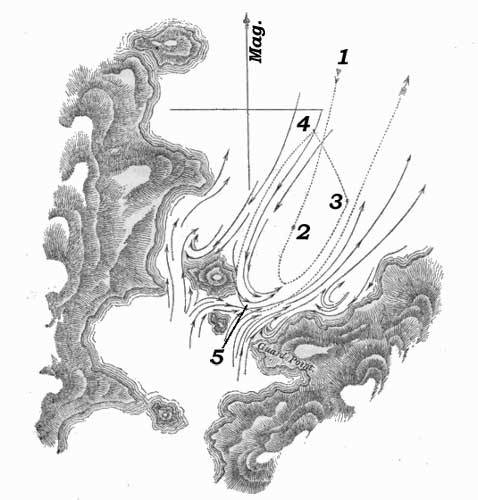
§ Numbers enlarged for readability.

“The wind was light from the north-eastward. Upon our reaching the station marked 1, without having previously noticed any current, we observed a strong ripjjling in the Narrow, and immediately sent the boats a-head to tow us towards mid-channel. We proceeded rather quickly until we arrived at 2, when our progress was checked, and we were carried rapidly back, as far as 3. In the Narrow the tide was evidently against us; but in crossing to the N.W. at 4, we were forced by the counter-current against all the efforts of the boats—were carried close to the large island—and for the space of thirty yards, were brushing the overhanging trees with our main-boom. This part was, most fortunately, quite steep; for had the vessel touched in her swift course, she must have been swung with violence against the rocks, and much damaged, perhaps irreparably.

“No sooner had we passed the end of this island, than we were shot into mid-channel to 5, and then as suddenly and swiftly carried back by the stream of the tide. The boats could never keep hold of the vessel while in these whirlpools; and it was several times fortunate that they had cast off the tow-rope in time, for thrice we were twisted round, as if on a pivot, by those violent eddies.

“A favourable moment was seized, the boats were again sent a-head; and, by great exertions, we were towed out of the influence of the tide, and then waited for the time of slack water.

“At three o'clock Mr. Kirke was sent to Guard Point, to ascertain the time of high water; and at half-past four, in consequence of his signal, we towed in with both boats, and passed the islands with a favouring tide; but one quarter of a mile farther, we met ripplings, which we had no sooner entered than a reverse of tide was found, as if the waters from the sounds were gradually forcing back the tide of the channel. We still, however, made progress to the S.W.; but it was not before eight o'clock that we anchored in the west entrance of this Narrow, pleased, indeed, to be again secure, and to have escaped unharmed.

“24th. Thick, hazy weather in the morning; but at eight o'clock it cleared a little, so we weighed, and soon reached the Ancon of Sarmiento. A strong S.E. wind, during the forenoon, carried us past Cape Ano Nuevo, and at noon we were near the opening into Smyth Channel, which I have called Victory Passage. We moored in Sandy Bay, in eight fathoms, purposing to remain during the next day (Sunday); and on the 26th, with a moderate wind from the northward, we left Sandy Bay, and stood to the south, passed the Elson Islands by noon, and at three moored in Hose Harbour. Next day we cleared Smyth Channel, and anchored in Deep Harbour.

“(28th.) Wind light and northerly. We towed out of Deep Harbour at daylight, stood across Beaufort Bay, and anchored in Tamar Bay; where, the weather being unfavourable, we remained during all the next day, filling water and cutting wood,—preparatory to our run to Monte Video,—in case of not finding the Adventure at the appointed rendezvous, Port Famine.

“On the 30th, with a moderate breeze from the N.W., we left Tamar Bay; but the wind soon after becoming contrary, we made but little progress, and anchored that evening in a small cove, near the east point of Upright Bay, where we passed the following day, in consequence of the wind continuing easterly, and causing much sea in the Strait.

“2d. Weighed, stood out, and made all sail, steering through the Strait. We passed Playa Parda early that afternoon, and Cape Quod soon afterwards, and as there was every appearance of a moderately fine night, continued our course. We hauled in near Port Gallant, when it grew dark, and burned a blue light, to call the attention of any vessel lying there; but no return was made, so we passed on. At midnight we were between Cape Holland and Cape Froward, the wind being light and the weather moderate.

“3d. On rounding Cape Froward, we beat up in-shore against a N.N.E. breeze, and in the evening were three or four miles to the northward of Point St. Isidro. After a tempestuous night, we reached Port Famine, where, to our great joy, we found the Adventure.”

With the exception of such fish and birds as had been previously observed near the Strait, Lieutenant Skyring and his party saw few living creatures. One novelty which Mr. Bynoe gave me was a splendid cormorant, which, being quite new, and the most beautiful of the genus, I named Phalacrocorax Imperialis.*

* Phal: capite cristato, collo posteriori, corporeque supra intense purpureis; alls scapularihusque viridi-atris; remigibus rectricibusque duodecim, fusco-atris; corpore subtus, fascia alarum maculdque dorsi medii sericeoalbis; rostro nigro; pedibus flavescentibus. Staluria Phal. Carbonis. It was found in the Inner Sounds, within the‘Ancon sin Salida.’—Proceed, of the Zool. Society, vol. i.; also Phil. Magazine, for March 1831, p. 227.

I also received a species of swan, quite distinct from the common one of the Strait, which has been long known as the black-necked swan (Anser nigricollis of Ind. Orn., ii. 834; and Latham, x. 2:3). Considering it an undescribed species, it was named Cygnus anatodoides.*

* C. albus remigibus primariis ad apicem nigris, rostro pedibusque rubris, illo lata subdepresso. Molina describes a Chilian duck thus. Anas Coscoroba—A. rostro extremo dilatato rotundnto, corpore albo, but I do not think it is the same as my specimen; certainly it is not Anser Candidus of Veillos, the ganso bianco of D'Azara, which the author of the Diet. D'Hist. Nat. (xxiii. 331.) supposes to be the same as A. Coscoroba (id. p. 332). Molina's description is very short, and does not mention the tips of the primary wing feathers being black.

Several deer were seen, but none obtained. There is reason, however, to suppose them to be of a novel species. The horns are short and straight.


CHAPTER XX

Beagle sails from San Carlos—Enter Strait—Harbour of Mercy—Cape Pillar—Apostles—Judges—Landfall Island—Cape Gloucester—Dislocation Harbour—Week Islands—Fuegians—Latitude Bay—Boat's crew in distress—Petrel—Passages—Otway Bay—Cape Tate—Fincham Islands—Deepwater Sound—Breaker Bay—Grafton Islands—Geological remarks—Barbara Channel—Mount Skyring—Compasses affected—Drawings—Provisions—Opportunities lost.

Captain Fitz Roy having received his orders on the 18th of November (see Appendix), sailed the following morning from San Carlos, and proceeding to the southward, approached the entrance of the Strait of Magalhaens on the night of the 24th. The following are extracts from his Journal:—

“At daylight on the 25th, with the wind at S.W., we made Cape Pillar right a-head (E.N.E. by compass), distant seven or eight leagues. The wind became lighter, and we were set by a current to the S.W., which obliged us, in nearing the Cape, to alter our course from E.N.E. to N.N.E., to avoid being carried too near the Apostle Rocks. A dangerous rock, under water, on which the sea breaks, lies half a mile more towards the north than either of the Apostles. Cape Pillar is a detached headland, and so very remarkable that no person can fail to know it easily.

“A very good latitude was obtained at noon, from which, and the astronomical bearing of the Cape, we made its latitude within half a mile of that given in the chart by Captain Stokes and Lieutenant Skyring; and the weather being clear and fine, sketches were taken of all the surrounding land. At one, we passed the Cape, and at three, anchored in the Harbour of Mercy. By the distance we had run, as shown by the patent log and compared with the chart, there had been a current against us of more than a knot an hour.

“In working into the harbour we passed over several patches of kelp, under which the bottom was plainly visible; but the lead never showed less than five fathoms, until we were about to anchor, when the vessel shot a-head into a weedy place, where we had three fathoms. This was about a cable's lensth in-shore (towards the highest mountain) of the spot marked by Lieutenant Skyring as good holding ground, to which we warped and anchored. It proved to be very good ground, being extremely tough clay.

“27th. A promising morning tempted me to try to obtain observations and a round of angles on or near Cape Pillar. I therefore left the ship with the master, and went in a boat to the Cape. To land near it in much swell was not easy upon such steep and slippery rocks: at last we got ashore in a cove, and hauled the instruments up the rocks by lines, but could get no further, on account of precipices. I, therefore, gave up that attempt, and went outside the Cape, to look for a better place; but every part seemed similar, and, as the weather was getting foggy, it was useless to persevere. In going to the Cape, and in returning, I measured the distance by a patent log, and found the mean of the two measurements agree with the chart. What current there was, ran to the westward.

“A small ox, which we had carried from Chilóe, was doomed to end his voyage at this place, and probably we were the first people who ever eat fresh beef in the Strait of Magalhaens.

“28th and 29th. Gloomy days, with much wind and rain; and the gusts coming so violently over the mountains, that we were unable to do any work, out of the ship.

“30th. Still blowing and raining.

“Dec. 1st and 2d. Cloudy days, with strong wind; but one short interval of sunshine was gladly made use of for rating our chronometers.

“3d. This morning we weighed, and worked out; and at one P.M. we were three miles westward of Cape Pillar, with every appearance of a N.W. gale. Shortly after, the weather became so thick, that I could not see any part of the coast; and therefore stood off shore, under low sail, expecting a bad night. Contrary to my expectation, the wind did not much increase; but the thick weather, and a heavy swell, induced me to stand farther out than I had at first intended. At eleven P.M., we wore and stood in until daylight on the 4th, when we found ourselves so much to the southward, that the land about Cape Pillar bore N. b. W., the Cape itself being shut in. We steered for the land, hoping to turn the day to some account; but those hopes soon ceased, for before we had run sufficient distance to make a serviceable base line, the weather became so thick as to oblige us to haul our wind. We saw just enough to make out a number of rocks and breakers, lying at a considerable distance off shore. After noon it was clearer, and we again stood in-shore; but found that the current was setting us so fast to the southward, that it was necessary to carry all sail and keep on a wind, to avoid losing ground; yet, with a fresh, double-reefed topsail breeze and a deeply laden weatherly vessel, we could not hold our own, and at seven in the evening were close to an islet which lies off Cape Sunday. We had seen very little of the coast thus far: the current had rendered the patent log useless for measuring bases, and the weather was very unfavourable for astronomical observations. The land appeared to be high and mountainous, as far as Cape Deseado, whence it seemed lower and more broken, forming a large bay between that cape and Cape Sunday. Many rocks on which the sea breaks violently lie at a distance from the shore, besides those two clusters called the ‘Apostles’ and the ‘Judges:’ the latter off Cape Deseado, and the former off Apostle Point, a little south of Cape Pillar.

“5th. To our mortification, we found ourselves a great way off shore; and Landfall Island, which was eight miles to leeward the last evening, was now in the wind's eye, at a distance of about six leagues. A strong wind, with much swell, prevented our regaining lost ground in a northerly direction, I therefore preferred standing to the S.E. by the wind, intending to seek for a harbour, as it seemed hopeless to try to survey this coast while under sail, with such obstacles to contend against as a current setting about a mile an hour, and a sky generally clouded over. Our only chance appeared to be, going from harbour to harbour and keeping close in-shore.

“Behind Landfall Island the coast forms a deep bay, apparently full of islands, and it is said there is in that part a communication with the Strait of Magalhaens. Looking from seaward there seems to be an opening.

“From the southern point of this bay the coast presents a high and regular line for a few miles, and then there is a succession of islets, rocks, and broken land. We stood in close to the breakers, but too late in the evening to find an anchorage. I observed kelp on the surface of the water, growing up from the bottom, while the lead gave a depth of forty-five fathoms. This was in a wild-looking, open bight, full of rocks and breakers, and much exposed.

“We stood off, close to the wind, hoping to make northing and westing during the night; but at midnight it fell calm, and at day-break on the 6th, to our astonishment, we found ourselves to the southward of Cape Gloucester, a high, remarkable promontory, standing out from the land as if it were an island, with a peaked top, which, from the southward, appears notched. The day proved very fine, and as a breeze sprung up from the S.E. and gradually increased, I had hopes of seeing more of the coast, along which we had been hustled so fast, and so much against our inclination.

“In running along shore, I noticed several inlets that seemed likely to afford good harbours. This coast has not, by any means, such a rugged and harsh appearance as I expected; but the number of islets and breakers is quite enough to give it a most dangerous character. The land is not very high near the sea, and seems to be wooded wherever the prevailing winds will allow trees to grow. Soundings were taken at various distances within four miles of the shore, and the depth generally was between twenty and one hundred fathoms. A good idea may be formed of the current which had taken us to the S.E., when I say that, even with a fresh and fair wind, it occupied us the whole of the 6th to regain the place we had left the previous evening.

“7th. At daylight it blew half a gale of wind; but we stood in, a little south of the cluster of rocks, called the Judges, towards a part of the shore which promised to afford a harbour. On closing it we saw an inlet, apparently large; but so fortified at the entrance by rocks and breakers, that I did not like to run in, without first sending a boat; yet it blew too strong, and there was too much sea, to lower one; therefore I stood off to wait for more moderate weather, for the place suited my purpose exactly, being near enough to the Judges, and Apostles, to fix their situation. This morning, Mr. Murray slipped across the forecastle and dislocated his shoulder: an accident which deprived us of his services for some time, and on account of it, we called the place where we anchored soon afterwards, Dislocation Harbour. So many rocks lie off this coast, that a vessel ought not to approach it unless she has daylight and clear weather. The lead will give warning, should the weather be thick, as soundings extend at least to four miles off shore, at which distance there are from thirty to one hundred fathoms, and generally speaking, there is less water as you approach the land.

“On the 8th, 9th, and 10th, we were busily occupied in surveying the harbour and adjacent coast. In this place water may be obtained very easily, as boats can lie in a fresh water stream which runs from the mountains. Wood is also plentiful. The harbour is large enough for four small vessels, and the bottom is very even, from fifteen to twenty-five fathoms, fine white sand. The entrance is narrow, but all dangers are visible, and now are laid down in the chart. It is much exposed to west winds, and the westerly swell, which might for weeks together prevent a vessel from getting out to sea.

“11th. A strong wind and much haziness prevented my weighing until near noon, when it became more moderate, though the weather was still thick. We then worked out with a light and variable breeze, which baffled us near the entrance, but at last we gained a good offing. I rejoiced to be outside, for our business in the harbour was over, and I had feared that west winds would detain us. The promontory, just to the southward of Dislocation Harbour, appeared to me to be ‘Cape Deseado,’ and that to the northward I called Chancery Point. Mr. Wilson ascended some heights at the back of the harbour, from which he saw many lakes, among barren and rugged hills; but a farther view was obstructed by other mountains.

“An oar was picked up near the watering place, and recognised by one of the men as the same which was left on a rock near Cape Pillar (in Observation Cove) by Captain Stokes, in January 1827. There could be no doubt of the fact, as the man's initials were on the oar, and it is curious as a proof of an outset along the south side of the Strait (near Cape Pillar), and of its continuation along shore. Traces of a fire were found, which showed that the natives visit even this most exposed part of the coast. The land above it here is high, and craggy; and very barren, except in the valleys, where much wood grows. Some wild fowl were seen and shot.

“From Cape Deseado, the coast is high and unbroken for three miles; (a rocky islet lies about a mile from the shore) then there is an opening which probably leads into a good harbour behind a number of islands. Several islands succeed, for a space of two miles, after which is Barrister Bay; an exposed place, full of islets, rocks, and breakers, extending nearly to Murray Passage. In sailing along this coast we passed inside of several breakers; and, I hope, noted all that lie in the offing: but, we cannot be sure, for breakers on rocks which are under the surface of the sea do not always show themselves. As it was getting dark, we hauled to the wind, near Cape Sunday, and, in doing so, were startled by a huge breaker which suddenly foamed up at a small ship's length from us. Although looking out on all sides we had not previously seen any break near that spot. During the night we carried a heavy press of sail to avoid being drifted to the S.E., and at daylight I rejoiced to find that we had not lost ground, so we steered for the land, and rounded Graves' Island. Observing several openings, I hauled close round a point, and tried to enter one of them; the wind, however, baffled us, and our anchor was let go in an exposed berth, but on good holding ground. We found a cluster of islands with so many anchorages between them, that thinking they ought to be surveyed, I returned on board, weighed, and worked towards the nearest opening. We shot into it, and warped to a berth four cables' lengths up a narrow passage, and anchored in twenty-four fathoms, upon sand and clayey mud.

“13th. Many wigwams were found in this neighbourhood, which showed that our Fuegian acquaintances were occasional visitors. The inner harbour seemed to be a fine basin; but the bottom was found inferior to that of the anchorage at which the Beagle lay moored.

“15th. Strong wind and frequent rain prevented much being done out of the ship this day. I went to the top of a mountain near the ship, but could not take many angles because of the violent squalls and the rain. At night it blew a hard gale: the squalls came furiously over the heights, and obliged us to let go a third anchor and strike topmasts. We were quite sheltered from the true wind; but were reached most effectually by the Williwaws, which came down with great force. However vexed we might have been at not being able to go far from the ship, we were certainly very fortunate in escaping this gale at a secure anchorage. It appeared to be blowing veiy heavily at sea.

“16th. A strong gale all day, with much rain, prevented our leaving the ship. In coming down a height on the 15th, I found some red porphyry rock, like that about Port Desire; and the first I had seen in these parts. Another novelty was a tract of about two acres of pure white sand thinly covered with grass.

“Though the middle of summer, the weather was not much warmer than in winter. The average height of the thermometer was about ten degrees greater; being nearly the same, as during the months of August and September, in Chilóe.

“17th. A continuance of bad weather: no work was done in the boats this day. In the afternoon I tried to go up the mountain I had ascended on Tuesday, to bring down a theodolite which I had left at the top; but the wind obliged me to return unsuccessful.

“18th. Similar weather continued until noon: frequent strong squalls, and rain: the sky being so constantly overcast that we saw neither sun nor stars. Although no progress was made in this weather, it was some satisfaction to think that we lost nothing but time; and that we saved much wear of the vessel by lying at anchor instead of being at sea. Being more moderate in the afternoon, our boats went away, and the ship was prepared for sailing. We tried to get some fur-seal, which were seen on a rock near the harbour, but they were too wary.

“My boat was almost capsized by a ‘blind breaker,’ which rose suddenly underneath her, and in an instant she was surrounded by and floated upon a white wave of foam, which broke all round and over, but without upsetting or swamping her.

“19th. Weighed and ran across to an anchorage in Landfall Island which I had seen from the heights. We anchored in a sheltered bay lying on the north side of the larger island, at the east opening of a passage which separates it from the smaller. These islands are high and, towards the sea, barren; but the sides of the hills, towards the east, are thickly wooded.

“A large smoke made near the bay showed us, that the Fuegians were in possession of our intended quarters; and soon after we anchored, a canoe came off to us full of men, women, and children, sixteen in all. They were in every respect similar to those we had so frequently met before; and from their unwillingness to part with furs or skins, unless for serviceable articles, such as knives, &c. appeared to have had dealings with Europeans: beads and trinkets they did not value. They had, in the canoe, many eggs, and dead birds, which they eat raw: the birds were a light blue, or dove-coloured, petrel, about eight inches long, which goes on land for a part of the year to lay eggs in holes in the ground. During this and the following day, we were fortunate enough to obtain observations, and nearly all the necessary bearings and angles.

“As yet I was pleased with the anchorage; the bottom shoaled gradually from twenty to five fathoms (fine sand), and it was sheltered from west winds, besides others, except north. Having obtained particularly good observations for latitude at this spot; I called it Latitude Bay. It is remarkably easy of access, and is also easy to leave: rather rare qualities in a Fuegian Harbour. Cape Innian being prominently situated, is a good guide to the anchorage.

“Sunday 20th. A fine day; and, knowing its value, we turned it to account. From a height I saw Cape Gloucester and the point of land on this (the northern) side of it; and to the northward I could distinguish the land about the entrance to the Strait. The Landfall Islands appeared to be the top of a ridge of mountains lying (partly below the sea) in the same direction as most of the neighbouring ranges. Many dangerous rocks lie off the S.W. side; and there is no passage for a ship between the islands, for the opening is narrow, and has only two fathoms in some places.

“21st. This morning I sent the master and Mr. Wilson* in a whale-boat to the east end of the island, to make a plan of that part, and get some angles and bearings necessary for continuing the survey.

* Mate, lent to the Beagle, from the Adventure.

“22d. A bad day, blowing hard and raining. The wind being from north and N.N.W. threw in a swell; and as we were not yet sure of the quality of the bottom, though apparently good, we struck topmasts and veered away a long scope of cable.

“24th. The wind shifted to the S.W. and became rather more moderate, though still squally, with much rain. It freshened again in the night, and backed to the northward.

“Christmas-day. Blowing strong from N.N.W. with a thickly clouded sky and heavy rain. I was very anxious to see the master return, but he could not in such weather. I feared that his provisions would be exhausted, having taken only enough for four days; yet they had a good tent, guns, and ammunition.

“26th. A strong wind with thick weather and much rain throughout the whole day. There was no possibility of sending a boat to the master, or of his returning by water. The island being very narrow he, or some of his party, could walk across, if they were in want of provisions, so as we did not hear from them I trusted that they had found wild fowl enough, and were not in distress.

“27th. Rather a more moderate morning with clearer weather. We looked out anxiously for the whale-boat, as, in such weather, she might get back to the ship without much difficulty. Before noon Mr. Wilson and the coxswain were seen on shore making signals to the ship; and a boat was sent immediately to bring them on board. They were very weak and tired, having walked across the island during the preceding afternoon and night, and having had no food for the last two days. The master and the other four men were said to be in a cove at the back of the island, and to have been without provisions since the 24th, not having been able to find either shellfish or wild fowl.

“At the time Mr. Wilson arrived on board, I was absent taking angles and bearings, but was soon infonned of his return, and at noon left the ship with a week's provisions for the master's party and my own boat's crew. I had not lost sight of the Beagle when I met the former returning. Having given them some food, and two fresh hands to help them in pulling to the ship (it being then quite moderate and fine) I continued my course to the place they had left, in order to do what the bad weather had prevented the master from doing. Being favoured with a fine afternoon I succeeded in obtaining the necessary angles and bearings, and returned to our vessel the following mornmg.

28th. At my return I found the master and his party nearly recovered. They had tried every day to return to the ship, but had been repeatedly forced back, at the risk of being driven out to sea. The gusts of wind from off the high land were so powerful as almost to upset the boat, although she had not even a mast up. Continual rain had wetted their ammunition and tinder, and they were then without fire or victuals: upon which Mr. Wilson and the coxswain set out, on Saturday afternoon, to acquaint us with their situation.

“When they came down to the sea-side the Fuegians took advantage of their weak state to beat the coxswain and take away some of his clothes; therefore after my return I went in search of them. They had however taken the alarm, and were all gone away. This party consisted of about twenty persons, eight of whom were men, and the rest women and children. When some of our officers went to their wigwams they appeared armed with clubs, spears, and swords, which seemed to have been made out of iron hoops, or else were old cutlasses worn very thin by frequent cleaning. They must have obtained these, and many trifles we noticed, from sealing vessels. By the visits of those vessels, I suppose, they have been taught to hide their furs and other skins, and have learned the effects of fire-arms. The chief part of their subsistence on this island appeared to be penguins, seal, young birds, and petrel which they take in a curious way. Having caught a small bird they tie a string to its leg and put it into a hole where blue petrels lay eggs. Several old birds instantly fasten upon the intruder, and are drawn out with him by the string.

“We weighed and worked out of the bay, increasing our depth of water very gradually as we left the shore, but having always the same bottom, fine speckled sand. I can safely recommend this bay as a good anchorage for shipping, and two cable's lengths N.N.W. of the Beagle's berth as the best place. Wood and water are not to be found so close to the anchorage as in other Fuegian harbours, but they may be obtained with very little trouble, and in any quantity, by going up the passage (between the islands) to one of many streams which run from the high land. There is plenty of water also very near the best berth, on the south side, but frequently a surf breaks on that beach. Two particular advantages which this roadstead* possesses, consist in the ease with which a vessel can enter or leave it, during any wind; and in its situation being well pointed out by a remarkable headland, named Cape Inman (in compliment to the Professor), which is high, with perpendicular cliffs, and almost detached from other land; so that a vessel, knowing her latitude within five miles of the truth, cannot fail to make it out, if the weather is tolerably clear. Wild fowl and shell-fish were very scarce there, probably because the Fuegians had scared or consumed them. From the top of a mountain, at the east end of the large island, I saw a great way down two channels or openings, which appeared to run far to the eastward, among many islands and very broken land. Such a succession of islets, rocks, and breakers, as the coast presented, was astonishing: many hundreds were counted while looking eastward from one station only.

* A small vessel may moor between the islands, instead of Ij'ing in the outer road.

“I wished much to know where these openings led, and whether there was a direct communication through them to the Strait, as seemed almost certain; but considering the time already spent, the extent of coast to be surveyed, and the small advantage of such information, except to satisfy curiosity, I determined to proceed to the next prominent headland, a mountain at the S.E. extremity of Otway Bay, whose position I had already fixed with respect to stations on Landfall Island.

“If there is a passage through those openings into Otway Bay, it must be unfit for vessels, being hampered with outlying rocks and breakers among which she could find no shelter in the event of rainy weather coming on before she cleared them; and clouds and rain are prevalent. As yet we had been extremely fortunate, in being under sail at intervals of fine weather, and anchored during the gales; but this was partly owing to a very careful attention to the barometer and sympiesometer.

“Having left Latitude Bay, we stood off until midnight, and then in shore again, carrying a press of sail all the time, in order to ‘hold our own’ against our old enemy, the current.

“At daylight (29th), not having been swept to leeward by the current, we were in a good position for continuing the survey from the place left the previous night. We bore up as soon as the land could be distinctly seen,—rounded Landfall Island very near the outer rocks, and then steered for Cape Tate (the extremity of the mountain I mentioned yesterday). Those outlying rocks are not very dangerous, as the sea always breaks violently upon them. In crossing Otway Bay, the morning being clear, I was enabled to add considerably to what had been already learned respecting the shores and dangers around it.(e)

(e) In Otway Bay, not far from Landfall Island, is a rock on which Mr. Low found Fuegians living among a number of (apparently) tame seals. See second volume.—R.F.§

§ Place in vol. 2 not yet found.

“Off Cape Tate, to the north and west, lie the College Rocks. Those nearest the Cape are also nearest the track of a ship running along the land, and half a mile west of them lies a detached and dangerous rock, under water. The sea generally breaks on it.

“We had very thick weather when close to those rocks, which obliged us to ‘haul our wind’ for half an hour; when, as it cleared, we steered round Cape Tate, about a mile off shore. I was in hopes of gaining an anchorage between it and the Fincham Islands, and therefore kept as near the land as I could; but seeing numerous breakers a-head and outside of me, I altered our course, and steered to go outside of all the rocks. After we had passed some of them, a large bight opened out to the north-eastward, and tempted me to haul up for it. We entered the sound at noon, and stood on for nearly four miles without finding an anchorage, or even gaining bottom with fifty fathoms of line, although at the entrance we had from twenty to ten fathoms. Thick weather coming on, made me very anxious to anchor somewhere, and we were now too much hampered to stand out again. We appeared to be among a multitude of islands, very near each other, yet without any anchorage between them; therefore, having no other resource, we let go both anchors upon the end of a steep-sided islet, where one fell into seven, the other into ten fathoms water, and hooked the rocks. Veering half a cable on each, we found forty fathoms under the stern, with a similar rocky bottom; so that we had the pleasant prospect of shouldering both our anchors, and drifting into deep water, with the first strong squall. During the remainder of that day, our boats were looking for better anchorage, but without success; they found patches of rocky ground with from ten to twenty fathoms here and there, but not one that could be preferred to our islet.

“30th. One Fuegian family was found here, consisting of a man and woman, with their children. During this day it rained too hard for anything to be done out of the ship; the wind was moderate; yet much as I disliked our rocky berth, it could not be changed.

“3lst. Moderate wind, with clearer weather. Mr. Murray and Mr. Stokes went away to different parts of the sound, while I was employed near the ship. Observations for latitude, longitude, and variation were made.

“1st January. During part of the last night and this morning, the wind blew strongly in squalls, and made me very anxious; but the weather rendered it impossible to move voluntarily, for it was raining hard as well as blowing. At about eight it cleared, and the wind shifted to the southward, when we weighed, and worked down the sound; but it was after noon before we had cleared its entrance, and seven in the evening before we were outside of all the breakers, the wind having been light and contrary the whole time.

“(2d.) At five this morning, being close to the Fincham Islands, with clear weather, and a fresh breeze from the N.W., we steered into Breaker Bay, towards a ragged-looking projecting point. Having approached as near as we could, and sounded, and taken angles, we steered so as to pass outside of some very outlying rocks, near the middle of the bay; for in-shore of them, I saw from the mast-head numerous breakers, rocks, and islets, in every direction. A worse place for a ship could scarcely be found; for, supposing thick weather to come on when in the depth of the bay, she would have lurking rocks and islets just awash with the water, on all sides of her, and no guide to take her clear of them, for soundings would be useless; and in such weather, the best chart that could be constructed would not help her. With this idea of the place, and for reasons similar to those which induced me to pass hastily across Otway Bay, I steered for Cape Gloucester, after passing the Midbay Rocks, at the distance of a quarter of a mile. The land at the bottom of the bay appeared to be distant, and much broken. Indeed, from the Week Islands to Cape Gloucester,(f) there is an almost innumerable succession of islands and rocks, without any continued tract of land, so that channels might be found in all directions; valuable, no doubt, to Fuegians in their canoes, but not often to seamen in ships, nor even to sealers; for where the natives go with their canoes, seals are never found in any numbers.

(f) And thence to the Strait of Le Maire.—R.F.

“In crossing Breaker Bay, even with a moderate wind, there was a very cross and awkward sea, owing, doubtless, to the ocean swell rolling into this deep bight. Such a swell would add much to the difficulty which vessels might find in getting out of this bay: I should therefore recommend them to avoid it particularly. Cape Gloucester is a most remarkable promontory, which can never be mistaken, after seeing even an indifferent sketch of it. At a distance it makes like a mountain rising out of the sea, but, on approaching nearer to it, a narrow neck of land appears.

“We found from twenty to thirty fathoms water, at the distance of a mile from the cape; and saw several outlying breakers about half a mile off shore. From the steep and rocky nature of these coasts one would not expect to find soundings until close to the land: but on every outer part of this coast, that we have visited, the bottom may be reached with the sounding line. Some natives were seen under the cape, who made a large fire. We stood into two bights, looking for anchorage, but, finding only rocks and breakers, steered along shore, rounded Ipswich Island, and hauled into a spacious bay, at the northern side of which there appeared to be several openings like harbours. In working across, we were agreeably surprised to find it a continued roadstead, open only towards the S.E., and having regular soundings, from twenty to fourteen fathoms. We anchored about a mile from the entrance of what seemed to be a harbour, at the N.W. corner, having worked up against a fresh N.W. wind. Our anchor was dropped in sixteen fathoms, and held well. I went directly to look at the opening, and found a passage, in which were good soundings, leading into a very snug basin, perfectly sheltered from wind and sea, in which the bottom was composed of sand and clay, and the depth of water from five to fifteen fathoms. As soon as I returned we weighed and worked up to the entrance of the basin; then anchored, warped into it, and moored with half a cable each way.

“This was the most secure and sheltered cove I had yet seen. It was called Laura Basin; and the bay we had crossed was named Euston Bay. I was very glad to discover so safe a place, because it enabled me to ascertain the position of Cape Gloucester and the neighbouring land, with the correctness which so prominent a place required, and because I hoped that it would prove useful as a harbour for vessels. From the top of a high ridge surrounding the basin, I thought Cape Gloucester seemed to be about seven miles off, and seeing a valley lead some distance in the desired direction, determined to go to it overland. I was so much pleased with the bay and the basin, that I did not hesitate to spend some time in the examination of their vicinity. The mountains hitherto examined between Cape Pillar and these (the Grafton) islands, consist of greenstone, slate, or sandstone (excepting those near Deep-water Sound, which are of very coarse-grained whitish granite); and from the continual action of such heavy seas as break on those shores, the sandstone and slate rocks wear away, and by their detritus not only the bottoms of harbours are covered, but a bank is formed which extends into the offing. A moderate depth of water and good anchorages were found near slaty or sandstone hills, but exactly the reverse in the vicinity of granite.(g)

(g) See second volume for further remarks on this subject.—R.F.§

§ Place in vol. 2 not yet found.

“4th. Early this morning I sent Mr. Murray in a whaleboat to examine and plan some openings I had noticed on the north side of Euston Bay; and Mr. Stokes to make a plan of the harbour, and the basin in which we were lying. The master carried six days' provisions with him, in case he should be detained, as on a former occasion, by bad weather. No place could be more convenient than this for such purposes as wooding and watering; and we took advantage of it to the utmost by filling the ship's hold. The water casks were filled in our boat, in perfectly smooth water, and the wood was cut close to the water side.

“6th. A party of twelve, consisting of the Purser, Mr. W. Wilson, Mr. Megget, eight seamen and myself, set out from the ship, intending to walk to Cape Gloucester. We landed in a valley at the N.W. corner of the harbour and began our march, two men carrying the tent, and the others our instruments and provisions: we had arms also, in case of meeting Indians. Difficult travelling, with such a cargo, very soon obliged us to stop and rest, but by continual changes with the heaviest loads, and great exertion on the part of those who carried them, we got over two-thirds of our journey in the course of the day, and at night pitched our tent, and defied the rain which poured incessantly until seven the following morning: when every height was covered with snow, as if it had been the middle of winter.

“7th. As soon as we had breakfasted we moved on again, and at noon reached the foot of a mountain which forms the Cape. Leaving the others to pitch our tent and cook some victuals, Mr. Wilson, Mr. Megget, and two seamen, ascended the mountain with me. A very severe task we had, but at last gained the highest pinnacle, where there was just room to place the theodolite and kneel by it, at the risk of a puff of wind canting us over either side. A stone moved from its place, would have reached the water as soon from one side as from the other. It was not a very clear day, but sufficiently so to enable me to gain the desired angles and bearings. From this summit I had a clear view of that dangerous place Breaker Bay, and was more confirmed in the idea I had formed of it, and rejoiced that I did not stand farther in with the Beagle. Having thus succeeded, and buried two memorials, one cased in tin and the other in a bottle, we filled our pockets with pieces of the rock and returned; rather too quickly, for the steepness of the hill assisted us more than we wished. During our absence some Fuegians had appeared, who were quiet and inoffensive; but they seemed very distrustful of us, and, before sun-rise next morning, were all gone except one man. These natives seemed to be very active and went up the mountain in about half the time that our party required. They had two canoes with them, but how they had reached this place by water was puzzling, when the exposed bay they must have crossed and the prevailing weather were considered. Perhaps they had carried their canoes overland, being rather like the Chilote piraguas, made of boards sewed together.

“8th. We heard the voices of the Fuegians at day-break this morning; but at four o'clock only one old man remained, who was probably left to watch us. We began our return, rather stiff from previous days' exertions, and looking dismally at the high rugged hills between the Beagle and ourselves. The first ascent on our way back was the worst of all: how the men carried their cargo so well astonished me, for with a very light load I was glad to rest frequently. Breakfast revived us, and by taking afterwards a better line we avoided the steepest hills and found much easier walking. While resting at our meal the weather was so clear that I got bearings of Cape Inman and other points more than fifty miles distant. There was very little variety or novelty in this walk through a Fuegian island. The same kind of scenery and the same species of plants and shrubs were found which we had seen every where else in Tierra del Fuego. Being more or less rocky made the only change. Of quadrupeds, excepting otters and dogs, I saw no traces, nor do I think any were to be found. A large kind of snipe, by some called a woodcock, and quails, of a large and, I think, peculiar species, were often seen and shot. The latter are not by any means so well tasted as the European quail, and their flesh is darker and coarser. At seven this evening we were again on board the Beagle, not a little tired.

“Should any future voyager feel inclined to make a similar excursion towards Cape Gloucester, he had better not think too lightly of his task.

“9th. Mr. Murray returned, having been into many openings between the islands to the eastward, and having collected much information. This afternoon it blew a heavy gale, but in such a sheltered place we only felt a few williwaws. From Mr. Murray's account it appeared that this island and those adjoining it to the eastward are a cluster lying together, but quite separated from the mainland, or rather the main body of islands, by a channel opening northward into Breaker Bay, and to the southward into Stokes Bay. They were called the Grafton Islands.

“10th. We had a heavy gale throughout this day with much rain. Bad weather, while at a good anchorage, I did not at that time regret, as the materials for our charts accumulated fast, and afforded no leisure time while we were detained on board.

“11th. A favourable day allowed us to examine and sound the outer roads, and obtain a round of angles from the western extreme of Ipswich Island, which completed my triangulation. Landing there was dangerous, and ascending the hill extremely difficult, on account of thick tangled brushwood which grows about three or four feet high on every part of the east side, and is so matted together as to be almost impenetrable. We generally scrambled over this jungle, but sometimes crept under it.

“12th. A tolerably fine day. The sun was visible both in the morning and afternoon; and from different summits Mr. Stokes and I took angles. The sky being clear near the horizon gave us a wide range. Meanwhile the ship was prepared to sail in search of a new place at which to employ our instruments. I hoped that this basin, harbour, and roadstead, might be of service, and therefore spared no pains about them. Eight latitudes were obtained by sets of circum-meridional altitudes; with four different sextants: two by Mr. Stokes, the rest by me: and as they all agreed, within fifteen seconds, I supposed their mean to be nearly correct. The sights for time were good, and the chronometers were going so steadily that dependence may be placed upon the accuracy of their results. To a vessel bound round Cape Horn and meeting with an accident, or in want of wood or water, this place might be useful. It is very easy to find, and easy to enter or depart from with the prevailing westerly winds.

“13th. We weighed and left the harbour, but the morning proved too hazy to allow of our running down the coast, therefore until eight o'clock we kept under easy sail in the roads. Being clear and moderate after that time, we passed Leading Island, and hove-to, to watch for a breaker near it. It broke but twice during the hour that we waited, therefore probably there is water enough to allow any vessel to pass in safety. At ten we bore up, and ran towards Isabella Island; my first object being to look for a place called by sealers ‘Hope Harbour,’ which, from what I could learn, ought to lie thereabouts. Its situation was not recognised by our boatswain,(h) who had been in it when sealing on this coast; so passing close to Isabella Island, we hauled our wind under the lee of the land, and came to an anchor in fifteen fathoms, sheltered from north to S.W. b. S. A high peaked hill, over the cove where I took observations, made this a suitable place for the business of the survey. Mr. Murray went up the height, while Mr. Stokes and I were employed near the water, till rain set in and drove us on board. This is the easternmost of the Grafton Islands. Beyond the channel, which separates them from the main body of islands, appeared a succession of broken land, not very high, but reaching apparently to a distant range of snowy mountains. The part nearest to us was a labyrinth of islets and rocks. Towards night the wind increased much, and drew to the S.W. and S.W. b. S. I was doubtful of our anchorage, and had the wind drawn one point more to the southward, we should have had a heavy sea to deal with, and must have slipped our cable.

(h) Mr. Sorrell, formerly with Mr. Weddell, and since that time with Mr. Brisbane.—R.F.

“14th. It moderated again, and the sun showed himself enough to enable us to get sights, and be on board in time to weigh at nine. We had reason to think a sealing vessel had been along this coast not long before us, by the traces our boats found in several places. Indians also had frequented these islands, for their wigwams were found everywhere. Observations on shore made our anchoring here of some consequence, although as a safe anchorage for other vessels, it is out of the question, being an exposed roadstead, with many rocks, both to seaward and in-shore. A sealer might use it, but not willingly I should think. As we ran towards the Agnes Islands, before a strong W.N.W. wind, many rocks and breakers showed themselves, and when we neared the islands, became numerous on each side of us. It would have been more prudent to have kept outside all of them; but I was anxious to find Hope Harbour, or run into the entrance of the Barbara Channel, and anchor in the north cove of Fury Island. Having passed the three Agnes Islands, and being nearly abreast of Cape Kempe,* our view became far from agreeable, for the sea, on all sides, seemed strewed with breakers; and how to steer so as to pass between them was perplexing. We were at this time running free, under treble reefed topsails, with top-gallant yards and masts on deck; the wind being strong from W.N.W., but the weather tolerably clear. Suddenly the boatswain hailed, ‘Hard-a-port, a rock under the bows!’ Round the little vessel turned, almost as fast as the order was given; but the thrill that shot through us was happily not the precursor of our destruction; for the supposed rock proved to be a huge whale which had risen close to the bows, and was mistaken for the top of a rock by the boatswain, who was looking out on the forecastle, while I was at the mast-head, and the ‘hands’ were upon deck. This part of the coast, from the Agnes Islands to Cape Schomberg, is the worst I have seen, it is so very broken, and has so many rocks and dangerous breakers lying at a long distance from the shore.

* The three peaks, in-shore of Cape Kempe, are very remarkable.

“At noon we were close to Fury Island; but the wind fell and prevented our making much progress. Fury Harbour, where the Saxe Cobourg was lost, is a wild exposed place, and, as the bottom is bad, it ought to be avoided by all vessels: there is but one patch of good ground, and that is very small.

“Passing round Fury Island, we entered the Barbara Channel, at the entrance to which stands Mount Skyring, a high, peaked, and most barren mountain, visible at a great distance. We all felt much additional interest in what was then seen, on account of the late survey in the Adelaide. Cape Schomberg and the Astrea Rock were easily known by Lieutenant Graves's sketch. To a high mountain, which in some views very much resembled the dome of St. Paul's, I gave that name (finding it out of the limits of Lieutenant Skyring's survey): it lies a short distance east of Cape Schomberg. A passage appeared to go to the eastward, passing from the Barbara channel, northward of Cape Schomberg and St. Paul's. Light baffling winds and an ebb-tide, of about a knot an hour, setting out of the Barbara, detained us until six p.m., between the Magill and Fury Islands; but soon after that hour we anchored in North Cove, a small but perfectly secure place. By reaching this anchorage, I had the satisfaction of being enabled to connect my work with Lieutenant Skyring's, and to take a fresh start for the next piece of coast. Hitherto we had been extremely fortunate, both with the ship and the boats; but such success could not be expected always.

“15th. Early this morning, Mr. Murray went in a whaleboat to the islands, near Cape Kempe, to ascertain the situations of some reefs and islets thereabouts, and sketch the outer coast. Mr. Stokes went in another boat to look for Hope Harbour, and examine part of the coast. The boatswain accompanied him, as he thought he knew his way by passages among the islands, although he had failed to recognise the place from the offing.

“16th. Bad weather, blowing a gale of wind and raining nearly all the day.

“17th. A squally and disagreeable day; but our boats made some progress.

“18th. Some Natives came alongside for a short time. As usual, we would not allow them to come on board, because of their being such dexterous thieves. A man to whom the canoe appeared to belong was far better featured, and more stoutly made, than any we had seen among the Fuegians. After bartering some of their very valuable property they left us.

“19th. Early this morning Mr. Stokes returned: he had been near enough to Hope Harbour, to see that it was in the Grafton Islands, and was one of the coves examined by Mr. Murray. He then returned as he had been desired; but made very good use of his time while away, by collecting materials for the charts. He fell in with a canoe under sail (the sail being a seal-skin); the first instance I had then known of a Fuegian canoe sailing. As far as Mr. Stokes could see to the northward, the land was very broken, or rather it was a mass of islands reaching to the base of a range of snowy mountains.

“North Cove is large enough to hold any vessel when moored; but the passage, in and out, is too narrow and difficult for a ship of more than three or four hundred tons, unless she uses warps. Being on the weather side of high land, but sheltered by low islands, williwaws do not annoy during westerly winds; but in a southerly gale I think they would be furious.

“My next task was to ascend Mount Skyring. As there was but little snow on it, and the ground quite clear of wood, the ascent was easy; but when at the summit I could not see far, because of low misty clouds. I had taken only a compass with me, intending to look round, and ascend a second time with my usual companion, a theodolite. After taking a few bearings, I moved the compass off its stand, and placed it on a stone; when, to my surprise, I found the bearing of a point, I had just been looking at, altered twenty degrees. Suspecting the cause, I put it on another stone, a few feet distant, and found the bearing again altered many degrees. I then examined the stones, and found there was much pyrites in them;* and that when broken, or struck against one another, they smelt strongly of sulphur. The compass was then replaced on its stand, and bearings of the same point taken from various spots, only a few feet apart, the point being many miles distant, and at each spot the compass gave a different bearing, and was very dull and sluggish, although it was a good Kater's compass, with a light card. Having thus satisfied myself of the very strong local attraction existing, I returned to the ship, intending to make no further use of a compass in this place; and as Lieutenant Skyring might have been deceived in his bearings from a similar cause, I hoped to procure a round of angles, with a theodolite set to a true bearing, which might be serviceable for his work, as well as my own. Many pieces of the stone, from different heights, were brought down; and in most of them were traces of metal.

* Specimens of the rock at the summit are in the collection at the Geological Society, numbered 184 and 188.

“The peaked top of this mountain is a mere heap of loose stones of all sizes. Whether the rock has been shattered in this manner by frost, by volcanic fire, or by lightning, I cannot tell; but I should think, from its appearance, by all three. Many of the stones are vitrified, and many are porous, like pumice-stones, although not so light.

“20th. I again went up Mount Skyring, taking a theodolite with me; and as the day was perfectly clear, and free from clouds, every point of land was visible, which can at any time be seen from that summit. Mount Sarmiento appeared in all its grandeur, towering above the other mountains to at least twice their height, and entirely covered with snow. Having set the theodolite to a painted post, fixed on shore near the Beagle (five miles distant), from which I had previously obtained the exact astronomical bearing of the spot on which the theodolite was placed; I obtained a most satisfactory round of angles, including most of the remarkable peaks, islands, and capes, within a range of forty miles from the mountain. The day was so fine, that it was not cold on the height, nor was there any wind to disturb the adjustment of the instrument.

This business being completed, I returned on board with Mr. Wilson, who, during the time I was on the height, made some very good sketches. Even at this early period his drawings were becoming a valuable addition to the gleanings of our cruise, and their number increased fast; for he took much pains with them, and produced not only good drawings, but most accurate delineations of the coast.

“21st. Fine weather for this climate. Mr. Murray returned in the whale-boat, having had a successful trip.

“By shooting and fishing we obtained frequent change of diet, for we shot much wild fowl (geese, shags, and ducks), and caught fish in the kelp, which were excellent eating. All that could be procured was regularly and equally distributed to the different messes in turn, and an account kept in a ‘game book.’ (Appendix.)

“22d. Mr. Stokes went to examine Fury Harbour, and returned late at night. In consequence of his account of the remains of the Saxe Cobourg sealing schooner, lost in that harbour, I sent a boat with the carpenter to collect from it some wood and bolts which might be useful to our ship, and remained at anchor for a day longer than I had intended.

“This day all hands were put upon two-thirds' allowance, but as it was a measure which affected the crew much and myself not at all, I was reluctant to give the necessary order, without first proposing the measure openly, and giving the following reasons:—

“Having succeeded beyond expectation in the examination of the coast thus far, and hoping to be able to continue the survey in the same manner, while our provisions lasted, I thought it better to shorten the allowance while all hands were well and hearty, and could obtain supplies of fish and wild fowl, rather than at a later period, when we might be otherwise situated. An extent of coast lay before us, and the parts particularly pointed out by Captain King, were yet unexamined.

“24th. A tolerably fine day; I tried all the compasses on shore, in three different places, placing them in a line to a distant mark; because in taking bearings, for the variation of the compass, during previous days, I had found very wide differences between the results of the same, as well as different compasses; and they were also very sluggish; the light cards being more so than the heavy ones. I found it impossible to reconcile their results by change of place or position, therefore it is probable that all the rock affected the needle; and I suspect that not only this island and the one on which Mount Skyring is situated, but most of the islands near are magnetic: particularly a cluster lying about a mile to seaward of the Magill Islands, on which, I believe, Lieutenant Skyring, or some of his party, took bearings. A boat was sent to watch the tide, on the day of new moon, at the entrance of the channel, and brought back a piece of the rock of which the last-mentioned cluster of islets consists. It is similar to that of Fury Island and Mount Skyring, apparently metallic, with a sulphureous smell, when struck or broken.* Small pieces put near the compass did not seem to affect it sensibly; but I did not spend time in trying the experiment with nicety, being satisfied of the general result. There may be metal in many of the Fuegian mountains, and I much regret that no person in the vessel was skilled in mineralogy, or at all acquainted with geology. It is a pity that so good an opportunity of ascertaining the nature of the rocks and earths of these regions should have been almost lost.

* Geological Society, Coll. No. 197.

“I could not avoid often thinking of the talent and experience required for such scientific researches, of which we were wholly destitute; and inwardly resolving, that if ever I left England again on a similar expedition, I would endeavour to carry out a person qualified to examine the land; while the officers, and myself, would attend to hydrography.”


CHAPTER XXI

Skyring's chart—Noir Island—Penguins—Fuegians—Sarmiento—Townshend Harbour—Horace Peaks—Cape Desolation—Boat lost—Basket—Search in Desolate Bay—Natives—Heavy gale—Surprise—Seizure—Consequences—Return to Beagle—Sail to Stewart Harbour—Set out again—Escape of Natives—Unavailing search—Discomforts—Tides—Nature of Coast—Doris Cove—Christmas Sound—Cook—York-Minster—March Harbour—Build a boat—Treacherous rocks—Skirmish with the Natives—Captives—Boat Memory—Petrel.

“25th. We weighed, and went round to Fury Harbour, for the carpenter and his cargo, and met him with a spar and a raft of plank, taken from the wreck. Having hoisted the boat up, and got the plank on board, we stood out towards the West Furies, by the wind; my intention being either to sail round Noir Island, or anchor under it, before running to the eastward, in order that no part of the sea-coast might be left unexamined. We passed very near some of the rocks, but as the day was fine and the weather clear, a good look-out at the mast-head could be trusted.

“Before leaving the vicinity of Mount Skyring, I should remark that the true bearing of Mount Sarmiento's summit, which I obtained from the top of Mount Skyring, laid off on Lieutenant Skyring's chart, passed as truly through his position of the summit as if the line had been merely drawn between them. This is highly creditable to his work, for I know he did not himself see Mount Sarmiento, when upon Mount Skyring.

“The breeze freshened, and drew more to the westward towards evening, I had therefore no hopes of nearing Noir Island. We saw the Tower Rocks distinctly before dark, and stood on towards them until ten o'clock, closing Scylla to avoid Charybdis, for in-shore of us lay all those scattered rocks, among which we had steered when passing the Agnes Islands and Cape Kempe.

“The night was spent in making short boards, under reefed topsails, over the same two miles of ground, as nearly as possible, with the lead going, and a thoroughly good look-out. At daylight next morning the wind became strong and the weather thick, with rain, but we made as much sail as we could carry, and worked to windward all the day. In the afternoon it moderated, and before dark we anchored in a very good roadstead, at the east end of Noir Island, sheltered from all winds from N. to S. b. E. (by the west); over a clear, sandy bottom; and with a sheltered cove near us where boats may land easily, and get plenty of wood and water. In working up to the Island, we passed very near a dangerous rock, under water, lying four miles off shore; and another, near the anchorage. The sea does not break on either of them when there is not much swell.

“27th. A fine day favoured us; the master went to one part of the island, and Mr. Stokes to another, while I went to a third. Having taken angles at the extreme west point (which ends in a cluster of rocks like needles), I passed quite round the island, and returned to the anchorage after dusk, landing here and there for bearings, in my way.

“There is a cove at the south part of the island, where boats would be perfectly safe in any weather, but the entrance is too narrow for decked vessels. The island itself is narrow and long, apparently the top of a ridge of mountains, and formed of sandstone,* which accounts for the bottom near it being so good, and for the needle-like appearance of the rocks at the west end; as the sand-stone, being very soft, is continually wearing away by the action of the water.

* Geological Society, No. 238 to 240, (perhaps clay-slate. P.P.K.)

“Multitudes of penguins were swarming together in some parts of the island, among the bushes and ‘tussac’* near the shore, having gone there for the purposes of moulting and rearing their young. They were very valiant in self-defence, and ran open-mouthed, by dozens, at any one who invaded their territory, little knowing how soon a stick could scatter them on the ground. The young were good eating, but the others proved to be black and tough, when cooked. The manner in which they feed their young is curious, and rather amusing. The old bird gets on a little eminence, and makes a great noise (between quacking and braying), holding its head up in the air, as if it were haranguing the penguinnery, while the young one stands close to it, but a little lower. The old bird having continued its clatter for about a minute, puts its head down, and opens its mouth widely, into which the young one thrusts its head, and then appears to suck from the throat of its mother for a minute or two, after which the clatter is repeated, and the young one is again fed; this continues for about ten minutes. I observed some which were moulting make the same noise, and then apparently swallow what they thus supplied themselves with; so in this way I suppose they are furnished with subsistence during the time they cannot seek it in the water. Many hair seal were seen about the island, and three were killed. Wild fowl were very numerous. Strange to say, traces of the Fuegians (a wigwam, &c.) were found, which shows how far they will at times venture in their canoes.

* Name given by sealers to a thick rushy kind of grass, which grows near the sea, in these latitudes.

“No danger lies outside of Noir Island, except in the Tower Rocks, which are above water, and ‘steep-to,’ but many perils lie to the south-eastward. Indeed, a worse place than the neighbourhood of Cape Kempe and the Agnes Islands could not often be found, I think: the chart of it, with all its stars to mark the rocks, looks like a map of part of the heavens, rather than part of the earth.

“28th. At daylight we sailed from these roads, and passed close to the Tower Rocks (within half a cable's length): they are two only in number, a mile and a half apart, and steep-sided. Thence we steered towards St. Paul's, my intention being to seek an anchorage in that direction. This day proved very fine and so clear that when we were becalmed, off St. Paul's, we saw Mount Sarmiento distinctly from the deck. A breeze carried us through Pratt Passage, which separates London Island from Sydney Island, to an anchorage in a good harbour, under a high peaked hill (Horace Peaks), which is a good mark for it. Finding no soundings in the Passage as we approached, gave us reason to be anxious; but in the harbour, the bottom proved to be excellent, and the water only of a moderate depth. As soon as we anchored, I tried to ascend Horace Peaks, but returned without having reached their summits before dark; however, I saw enough to give me a general idea of the distribution of the land and water near us. I thought that this anchorage would be favourable for ascertaining the latitude of Cape Schomberg* with exactness: having found a considerable difference between our chart and that of Lieutenant Skyring, respecting the latitude of that promontory.

* A high mountain at'the N.W. end of London Island.

“Meanwhile I contemplated sending the master to a headland called by Cook, Cape Desolation, and which well deserves the name, being a high, craggy, barren range of land. I was not sorry to find myself in a safe anchorage, for the weather seemed lowering; and after being favoured with some moderate days, we could not but expect a share of wind and rain.

“29th. This morning the weather looked as if we should be repaid for the few fine days which we had enjoyed; but as we felt it necessary to work in bad weather as well as in good, it did not prevent the master from setting out on his way to Cape Desolation; near which, as a conspicuous headland, whose position would be of great consequence, he was to search for a harbour, and obtain observations for connecting the survey. He could not have been in a finer boat (a whale-boat built by Mr. May, at San Carlos); and as he well knew what to do with her, I did not feel uneasy for his safety, although after his departure the wind increased rapidly, and towards evening blew a hard gale. The barometer had not given so much warning as usual; but it had been falling gradually since our arrival in this harbour, and continued to fall. The sympiesometer had been more on the alert, and had fallen more rapidly.

“(30th.) A continued gale, with rain and thick weather throughout the clay. During the night the weather became rather more moderate; but on the morning of the 31st, the wind again increased to a gale, and towards noon, the williwaws were so violent, that our small cutter, lying astern of the ship, was fairly capsized, though she had not even a mast standing. The ship herself careened, as if under a press of sail, sending all loose things to leeward with a general crash (not being secured for sea, while moored in so small a cove), but so rapidly did these blasts from the mountains pass by, that with a good scope of chain out, it was hardly strained to its utmost before the squall was over. While the gale was increasing, in the afternoon, the topmasts were struck; yet still, in the squalls, the vessel heeled many strakes when they caught her a-beam. At night they followed in such rapid succession, that if the holding-ground had not been excellent, and our ground-tackle very strong, we must have been driven on the rocks.

“Under the lee of high land is not the best anchorage in these regions. When good holding-ground can be found to windward of a height, and low land lies to windward of the anchorage, sufficient to break the sea, the place is much to be preferred; because the wind is steady and does not blow home against the height. The lee side of these heights is a great deal worse than the west side of Gibraltar Rock while the strongest Levanter is blowing.

“Considering that this month corresponds to August in our climate, it is natural to compare them, and to think how hay and corn would prosper in a Fuegian summer. As yet I have found no difference in Tierra del Fuego between summer and winter, excepting that in the former the days are longer, and the average temperature is perhaps ten degrees higher, but there is also then more wind and rain.

“The gale still continued, and prevented any thing being done out of the ship. However safe a cove Mr. Murray might have found, his time, I knew, must be passing most irksomely, as he could not have moved about since the day he left us. He had a week's provisions, but with moderate weather would have returned in three days.

“Feb. 2d. Still very squally and unsettled. This gale began at N.N.W., and drew round to S.S.W. Much rain comes usually from the N.W. quarter; and as the wind draws southward, the weather becomes clearer. The squalls from the southern quarter bring a great deal of hail with them.

“3d. I was enabled to take a round of angles from Horace Peaks, over the ship, the sky being clear near the horizon. The theodolite had been left near the top since the 28th, each day having been too bad to use it. These peaked hills required time and exertion in the ascent; but the wide range of view obtained from their summits on a clear day, amply repaid us for both. If the height was sufficient, it gave a bird's-eye view of many leagues, and showed at a glance where channels lay, which were islands, and what was the nature of the surrounding land and water. The shattered state of all these peaks is remarkable: frost, I think, must be the chief cause.

“After being deceived by the magnetism of Mount Skyring and other places, I never trusted the compass on a height, but always set up a mark near the water, at some distance, and from it obtained the astronomical bearing of my station at the summit. This afternoon we prepared the ship to proceed as soon as the master should arrive.

“4th. Moderate weather. I was surprised that the master did not make his appearance; yet, having full confidence in his prudent management, and knowing that he had been all the time among islands, upon any one of which he could haul up his boat and remain in safety during the gales, I did not feel much anxiety, but supposed he was staying to take the necessary angles and observations, in which he had been delayed by the very bad weather we had lately experienced.

“At three this morning (5th), I was called up to hear that the whale-boat was lost—stolen by the natives; and that her coxswain and two men had just reached the ship in a clumsy canoe, made like a large basket, of wicker-work covered with pieces of canvas, and lined with clay, very leaky, and difficult to paddle. They had been sent by the master, who, with the other people, was at the cove under Cape Desolation, where they stopped on the first day. Their provisions were all consumed, two-thirds having been stolen with the boat, and the return of the natives, to plunder, and perhaps kill them, was expected daily.

“The basket, I cannot call it a canoe, left the Cape (now doubly deserving of its name) early on the morning of the 4th, and worked its way slowly and heavily amongst the islands, the men having only one biscuit each with them. They paddled all day, and the following night, until two o'clock this morning (5th), when in passing the cove where the ship lay, they heard one of our dogs bark, and found their way to us quite worn out by fatigue and hunger. Not a moment was lost, my boat was immediately prepared, and I hastened away with a fortnight's provisions for eleven men, intending to relieve the master, and then go in search of the stolen boat. The weather was rainy, and the wind fresh and squally; but at eleven o'clock I reached the cove, having passed to seaward of the cape, and there found Mr. Murray anxiously, but doubtfully, awaiting my arrival. My first object, after inquiring into the business, was to scrutinize minutely the place where the boat had been moored, (for I could not believe that she had been stolen;) but I was soon convinced that she had been well secured in a perfectly safe place, and that she must, indeed, have been taken away, just before daylight, by the natives. Her mast and sails, and part of the provisions were in her; but the men's clothes and the instruments had fortunately been landed. It was the usual custom with our boats, when away from the ship, to keep a watch at night; but this place appeared so isolated and desolate, that such a precaution did not seem necessary. Had I been with the boat, I should probably have lost her in the same manner; for I only kept a watch when I thought there was occasion, as I would not harass the boat's crew unnecessarily; and on this exposed and sea-beaten island, I should not have suspected that Indians would be found. It appeared that a party of them were living in two wigwams, in a little cove about a mile from that in which our boat lay, and must have seen her arrive; while their wigwams were so hidden as to escape the observation of the whale-boat's crew. At two o'clock on the first morning, Mr. Murray sent one of the men out of the tent to see if the boat rode well at her moorings in the cove, and he found her secure. At four another man went to look out, but she was then gone. The crew, doubtful what had been her fate, immediately spread about the shore of the island to seek for traces of her, and in their search they found the wigwams, evidently just deserted: the fire not being extinguished. This at once explained the mystery, and some proceeding along the shore, others went up on the hills to look for her in the offing; but all in vain. The next morning Mr. Murray began the basket, which was made chiefly by two of his men out of small boughs, and some parts of the tent, with a lining of clayey earth at the bottom. Being on an island, about fifteen miles from the Beagle, their plan was as necessary as it was ingenious: though certainly something more like a canoe than a coracle could have been paddled faster.

“The chronometer, theodolite, and other instruments having been saved, Mr. Murray had made observations for fixing the position of the place, and had done all that was required before I arrived, when they embarked, with their things, in my boat, which then contained altogether eleven men, a fortnight's provisions, two tents,* and clothing; yet with this load she travelled many a long mile, during the following week, a proof of the qualities of this five-oared whale-boat, which was also built by Mr. Jonathan May, our carpenter, while we were at San Carlos.

* I carried two tents from the Beagle, theirs having been cut up for the basket.

“The very first place we went to, a small island about two miles distant, convinced us still more decidedly of the fate of our lost boat, and gave us hopes of retrieving her; for near a lately used wigwam, we found her mast, part of which had been cut off with an axe that was in the boat. Our next point was then to be considered, for to chase the thieves I was determined. North and east of us, as far as the eye could reach, lay an extensive bay in which were many islands, large and small; and westward was a more connected mass of large islands reaching, apparently, to the foot of that grand chain of snowy mountains, which runs eastward from the Barbara Channel, and over the midst of which Sarmiento proudly towers. I resolved to trace the confines of the bay, from the west, towards the north and east, thinking it probable that the thieves would hasten to some secure cove, at a distance, rather than remain upon an outlying island, whence their retreat might be cut off. In the evening we met a canoe containing two Fuegians, a man and a woman, who made us understand, by signs, that several canoes were gone to the northward. This raised our hopes, and we pushed on. The woman, just mentioned, was the best looking I have seen among the Fuegians, and really well-featured: her voice was pleasing, and her manner neither so suspicious nor timid as that of the rest. Though young she was uncommonly fat, and did justice to a diet of limpets and muscles. Both she and her husband were perfectly naked. Having searched the coves for some distance farther, night came on, and we landed in a sheltered spot.

“The next day (6th), we found some rather doubtful traces of the thieves. Towards night it blew a strong gale, with hailsqualls and rain.

“On the 7th, at a place more than thirty miles E.N.E. of Cape Desolation, we fell in with a native family, and on searching their two canoes found our boat's lead line. This was a prize indeed; and we immediately took the man who had it into our boat, making him comprehend that he must show us where the people were, from whom he got it. He understood our meaning well enough, and following his guidance we reached a cove that afternoon, in which were two canoes full of women and children; but only one old man, and a lad of seventeen or eighteen. As usual with the Fuegians, upon perceiving us they all ran away into the bushes, carrying off as much of their property as possible—returning again naked, and huddling together in a corner. After a minute search, some of the boat's gear was found, part of her sail, and an oar, the loom of which had been made into a seal-club, and the blade into a paddle. The axe, and the boat's tool-bag were also found, which convinced us that this was the resort of those who had stolen our boat; and that the women, six in number, were their wives. The men were probably absent, in our boat, on a sealing expedition; as a fine large canoe, made of tirplank, perhaps from the wreck of the Saxe Cobourg, was lying on the beach without paddles or spears. She did not come there without paddles: and where were the spears of which every Fuegian family has plenty? It was evident that the men of the party had taken them in our boat, and had cut up our oars like the one they had accidentally left. The women understood what we wanted, and made eager signs to explain to us where our boat was gone. I did not like to injure them, and only took away our own gear, and the young man, who came very readily, to show us where our boat was, and, with the man who had brought us to the place, squatted down in the boat apparently much pleased with some clothes and red caps, which were given to them. We had always behaved kindly to the Fuegians wherever we met them, and did not yet know how to treat them as they deserved, although they had robbed us of so great a treasure, upon the recovery or loss of which much of the success of our voyage depended. Following the guidance of these two natives, we pulled against wind and rain until dark, when it became absolutely necessary to secure our boat for the night, deeply laden as she was with thirteen people. As we were then at a great distance from the place, whence we brought the natives, having pulled for four hours along shore, and as they seemed to be quite at their ease, and contented, I would not secure our guides as prisoners, but allowed them to lie by the fire in charge of the man on watch. About an hour before daylight, although the look-out man was only a few yards distant from the fire, they slipped into the bushes, and as it was almost dark were immediately out of sight. Their escape was discovered directly, but to search for them during darkness, in a thick wood, would have been useless; besides, our men were tired with their day's work, and wanted rest, so I would not disturb them until daylight (8th), when we continued our search in the direction the natives had indicated; but after examining several coves without finding any traces of Fuegians, we hastened back towards the wigwams we had visited on the previous day. Sailing close along-shore, a large smoke suddenly rose up, out of a small cove close by us, where we immediately landed, and looked all round; but found only the foot-prints of two Fuegians, probably the runaways, who had just succeeded in lighting a fire at the moment we passed by. This shows how quickly they find materials for the purpose, for when they left us, they had neither iron nor fire-stone (pyrites), nor any kind of tinder. They had carried off two tarpaulin coats, which Mr. Murray had kindly put on to keep them warm; although, treated as he had so lately been, one might have thought he would not have been the first to care for their comfort. I mention these incidents to show what was our behaviour to these savages, and that no wanton cruelty was exercised towards them.

“After looking for these two natives, and for Mr. Murray's coats, which at that time he could ill spare, we returned to our boat, and pushed on towards the wigwams. The moment the inmates saw us, they ran away, and we gave chase, trying, in vain, to make them stop. Disappointed in the hope of obtaining a guide, we determined to prevent these people from escaping far, and spreading any intelligence likely to impede the return of our boat, which we daily expected: we therefore destroyed two canoes, and part of a third, that the natives were building, and burned every material which could be useful to them in making another canoe.

“(9th). Next day, we went straight across the bay to Cape Desolation, against a fresh breeze: by pulling in turns, the boat was kept going fast through the water, and late in the evening we reached the cove from which the thieves had first started, when they stole the boat; but no traces of their having been there again, were found. I thought it probable that they would return to see what had become of our party, and whether our people were weak enough to be plundered again, or perhaps attacked.

“This idea proving wrong, we retraced (10th) much of our former course, because the direction pointed out by the Fuegians who ran away from us seemed to lead towards the place we now steered for, Courtenay Sound, and was a probable line for the thieves to take. During the night it blew a gale from the southward, which increased next day (11th), and became more and more violent until the morning of the 12th, when it abated.

“We continued our search, however, sometimes under a close-reefed sail; sometimes on our oars, and sometimes scudding with only the mast up. Although the wind was very violent, too strong for a close reefed sail (with four reefs), the water was too much confined by islands to rise into a sea, but it was blown, as ‘spoon drift,’ in all directions. This day the Beagle had her topmasts and lower yards struck, for the gale was extremely heavy where she lay. The barometer foretold it very well, falling more than I had previously seen, although the wind was southerly. In an exposed anchorage, I do not think any vessel could have rode it out, however good the holding ground.

“12th. This morning the weather was better, and improving fast. We went over much ground without the smallest success, and in the afternoon steered to the eastward again, for a third visit to the boat stealers' family. As it was late when we approached the place, I landed half our party, and with the rest went to reconnoitre. After a long search we discovered the Indians in a cove, at some distance from that in which they were on the previous day; and having ascertained this point, taken a good view of the ground, and formed our plans, we returned to our companions, and prepared for surprising the natives and making them prisoners. My wish was to surround them unawares, and take as many as possible, to be kept as hostages for the return of our boat, or else to make them show us where she was; and, meanwhile, it was an object to prevent any from escaping to give the alarm.

“13th. Whether the men belonging to the tribe had returned during our absence, was uncertain, as we could not, without risk of discovery, get near enough to ascertain: but, in case we should find them, we went armed, each with a pistol or gun, a cutlass, and a piece of rope to secure a prisoner. We landed at some distance from the cove, and, leaving two men with our boat, crept quietly through the bushes for a long distance round, until we were quite at the back of the new wigwams; then closing gradually in a circle, we reached almost to the spot undiscovered; but their dogs winded us, and all at once ran towards us barking loudly. Further concealment was impossible, so we rushed on as fast as we could through the bushes. At first the Indians began to run away; but hearing us shout on both sides, some tried to hide themselves, by squatting under the banks of a stream of water. The foremost of our party, Elsmore by name, in jumping across this stream, slipped, and fell in just where two men and a woman were concealed: they instantly attacked him, trying to hold him down and beat out his brains with stones; and before any one could assist him, he had received several severe blows, and one eye was almost destroyed, by a dangerous stroke near the temple. Mr. Murray, seeing the man's danger, fired at one of the Fuegians, who staggered back and let Elsmore escape; but immediately recovering himself, picked up stones from the bed of the stream, or was supplied with them by those who stood close to him, and threw them from each hand with astonishing force and precision. His first stone struck the master with much force, broke a powder-horn hung round his neck, and nearly knocked him backwards: and two others were thrown so truly at the heads of those nearest him, that they barely saved themselves by dropping down. All this passed in a few seconds, so quick was he with each hand: but, poor fellow, it was his last struggle; unfortunately he was mortally wounded, and, throwing one more stone, he fell against the bank and expired. After some struggling, and a few hard blows, those who tried to secrete themselves were taken, but several who ran away along the beach escaped: so strong and stout were the females, that I, for one, had no idea that it was a woman, whose arms I and my coxswain endeavoured to pinion, until I heard someone say so. The oldest woman of the tribe was so powerful, that two of the strongest men of our party could scarcely pull her out from under the bank of the stream. The man who was shot was one of those whom we had taken in the boat as a guide, and the other was among our prisoners. Mr. Murray's coats were found in the wigwams divided into wrappers to throw over the shoulders. We embarked the Indians (two men, three women, and six children), and returned to the spot where we had passed the preceding night. One man who escaped was a one-eyed man we had seen before; he was more active than any, and soon out of our reach. Two or three others escaped with him, whom I did not see distinctly.

“That a life should have been lost in the struggle, I lament deeply; but if the Fuegian had not been shot at that moment, his next blow might have killed Elsmore, who was almost under water, and more than half stunned, for he had scarcely sense to struggle away, upon feeling the man's grasp relax. When fairly embarked, and before we asked any questions, the natives seemed very anxious to tell us where our boat was; but pointed in a direction quite opposite to that which they had previously shown us. We guarded them carefully through the night, and next morning (14th) set out upon our return to the Beagle, with twenty-two souls in the boat. My object was, to put them in security on board, run down the coast with the ship to some harbour more to the eastward, and then set out again upon another search; carrying some of my prisoners as guides, and leaving the rest on board to ensure the former remaining, and not deceiving us. We made tolerable progress, though the boat was so over-loaded, and on the 15th reached the Beagle with our living cargo. In our way we fell in with a family of natives, whose wigwams and canoes we searched; but finding none of our property, we left them not only unmolested, but gave them a few things, which in their eyes were valuable.

“This conduct appeared to surprise our prisoners, who, as far as we could make out, received a wholesome lecture, of assistance, from the strangers. At all events, when they parted, our passengers were as discontented as the others were cheerful. When we got on board, we fed our prisoners with fat pork and shell-fish, which they liked better than any thing else, and clothed them with old blankets.*

* It afterwards appeared that we had taken the families of the very men who stole the boat from Mr. Murray.

“Next morning (16th) we weighed, and sailed along the coast towards Cape Castlereagh, at the east side of Desolate Bay. Many straggling rocks and rocky islets were observed lying off Cape Desolation and in the Bay. That afternoon, we stood into a narrow opening, which appeared to be the outlet of a harbour close to Cape Castlereagh, and found a very good anchorage, well suited for the purposes both of continuing the survey and looking for the lost boat.

“(17th.) The master and I, with the cutter and a whaleboat, set out upon a second chase, taking a week's provisions. In the first cove I searched, not two miles from the Beagle, I found a piece of the boat's lead-line, which had been left in a lately deserted wigwam. This raised our hopes; and, in addition to the signs made by our prisoners, convinced us we were on the right track.

“I took with me a young man as a guide, and in the cutter the master carried the two stoutest of the women, having left all the rest of our prisoners on board. As far as we could make out, they appeared to understand perfectly that their safety and future freedom depended upon their showing us where to find the boat.

“We intended to go round the Stewart Islands; and after examining many coves, and finding signs that a party of natives had passed along the same route within the last two days, we stopped in a sheltered place for the night. Having given our prisoners as much food as they could eat, muscles, limpets, and pork, we let them lie down close to the fire, all three together. I would not tie them, neither did I think it necessary to keep an unusual watch, supposing that their children being left in our vessel was a security for the mothers far stronger than rope or iron. I kept watch myself during the first part of the night, as the men were tired by pulling all day, and incautiously allowed the Fuegians to lie between the fire and the bushes, having covered them up so snugly, with old blankets and my own poncho, that their bodies were entirely hidden. About midnight, while standing on the opposite side of the fire, looking at the boats, with my back to the Fuegians, I heard a rustling noise, and turned round; but seeing the heap of blankets unmoved, satisfied me, and I stooped down to the fire to look at my watch. At this moment, another rustle, and my dog jumping up and barking, told me that the natives had escaped. Still the blankets looked the same, for they were artfully propped up by bushes. All our party began immediately to search for them; but as the night was quite dark, and there was a thick wood close to us, our exertions were unavailing.

“Believing that we could not be far from the place where the natives supposed our boat to be, I thought that they would go directly and warn their people of our approach; and as the island was narrow, though long, a very little travelling would take them across to the part they had pointed out to us, while it might take a boat a considerable time to go round; I therefore started immediately to continue the search in that direction, and left the master to examine every place near our tents.

“In the afternoon of the same day I returned to him, having traversed a long extent of coast without finding an outlet to sea-ward, or any traces of the lost boat. Meanwhile Mr. Murray had searched every place near our bivouac without success; but he found the spot where the Fuegians had concealed themselves during the night, under the roots of a large tree, only a dozen yards from our fire.

“As it was possible that the thieves might have returned to the place whence we had taken the natives, I desired the master to cross the sound and go there, and afterwards return to meet me, while I continued the search eastward. With a fair and fresh wind I made a good run that evening, found a passage opening to the sea,* and a wigwam just deserted. Here was cause for hope; and seeing, beyond the passage, some large islands lying to seaward of that which we had been coasting, it appeared probable that our boat had been taken there for seal-fishing. Our prisoners had given us to understand plainly enough that such was the object of those who had stolen her, and outlying islands were the most likely to be visited, as on them most seal are found.

* Adventure Passage.

“Next day (19th) I passed over to Gilbert Island, and in a cove found such recent marks of natives, that I felt sure of coming up with the chase in the course of the day. When the Fuegians stop anywhere, they generally bark a few trees, to repair their canoes or cover their wigwams; but those whose traces we were following, had made long journeys without stopping; and, where they did stay, barked no trees, which was one reason for supposing them to be the party in our boat. In the course of the day we pulled nearly round the islands,* looking into every cove.

* Gilbert Islands.

“On the 20th, we discovered three small canoes with their owners in a cove.* All the men ran away, except two. As we saw that there were no more persons than the canoes required, we did not try to catch them, knowing that this could not be the party we were in search of. We had now examined every nook and corner about these islands, and I began to give up all hope of finding our boat in this direction. Having no clue to guide me farther, and much time having been lost, I reluctantly decided to return to the Beagle. Our only remaining hope, that the master might have met with the boat, was but very feeble.

* Doris Cove.

“(21st.) All this day we were pulling to the westward, to regain the Beagle. At night-fall I met Mr. Murray, with the cutter, in the cove where I had appointed a rendezvous. He had not found any signs of the boat upon the opposite shore, and therefore returned; but he saw the people who had escaped from us when we surprised the whole family. They fled as soon as his boat was seen. Leaving, therefore, three men to watch in the bushes, he stood out to sea in the boat; and the stratagem succeeded sufficiently to enable our men to get very near to the natives, but not to catch any of them. One old man squinted very much, and in other respects exactly answered the description of a Fuegian who ill-treated some of the Saxe Cobourg's crew, when they were cast away in Fury Harbour. I wish we could have secured him; but he was always on the alert, and too nimble for our people. In their canoe, which was taken, was found the sleeve of Mr. Murray's tarpaulin coat, a proof that these people belonged to the tribe which had stolen our boat. The canoe was a wretchedly patched affair, evidently put together in a great hurry.

“Next morning (22d) the master and I set out on our return to the Beagle; but seeing a great smoke on the opposite shore, in Thieves' Sound, I thought it must be made by the offenders, who, having returned and found their home desolate, were making signals to discover where their family was gone: sending the cutter therefore on board, I pulled across the sound towards the smoke. As the distance was long, and the wind fresh against us, it was late before I arrived; yet the smoke rose as thickly as ever, exciting our expectations to the utmost:—but, to our disappointment, not a living creature could be seen near the fire, nor could any traces of natives be found. The fire must have been kindled in the morning, and as the weather was dry, had continued to burn all day.

“We were then just as much at a loss as ever, for probably (if that was the party), they had seen us, and would, for the future, be doubly watchful. At first we had a chance of coming upon them unawares, but the time for that had passed: every canoe in the sound had been examined, and all its inhabitants knew well what we were seeking.

“It blew too strong, and it was too late, to recross Whaleboat Sound that night, so I ascended a height to look round. Next morning (23d) we again searched many miles of the shores of Thieves' Sound without anv success; and afterwards sailed across to Stewart Harbour. We reached the Beagle in the evening, but found that all the other prisoners, excepting three children, had escaped by swimming ashore during the preceding night. Thus, after much trouble and anxiety, much valuable time lost, and as fine a boat of her kind as ever was seen being stolen from us by these savages, I found myself with three young children to take care of, and no prospect whatever of recovering the boat. It was very hard work for the boats' crews, for during the first ten days we had incessant rainy weather, with gales of wind; and though the last few days had been uncommonly fine, the men's exertions in pulling about among the coves, and in ascending hills, had been extremely fatiguing.

“While the bad weather lasted, the men's clothes were seldom dry, either by day or night. Frequently they were soaked by rain during the greater part of the day, and at night they were in no better condition; for although a large fire (when made) might dry one side, the other as quickly became wet. Obliged, as we were, to pitch our small tent close to the water in order to be near our boat;—and because every other place was either rocky or covered with wood;—we were more than once awakened out of a sound sleep by finding that we were lying partly in the water, the night-tide having risen very much above that of the preceding day: although the tides should have been at that time ‘taking off’ (diminishing).

“Sometimes extreme difficulty was found in lighting a fire, because every thing was saturated with moisture; and hours have been passed in vain attempts, while every one was shivering with cold,—having no shelter from the pouring rain,—and after having been cramped in a small boat during the whole day.

“In Courtenay Sound I saw many nests of shags (cormorants) among the branches of trees near the water: until then, I had understood that those birds usually, if not invariably, built their nests on the ground or in cliffs.

“Much time had certainly been spent in this search, yet it ought not to be considered as altogether lost. Mr. Stokes had been hard at work during my absence, making plans of the harbours, and taking observations, and I am happy to say, that I had reason to place great confidence in his work, for he had always taken the utmost pains, and had been most careful. My wanderings had shown me that from the apparent sea coast to the base of that snowy chain of mountains which runs eastward from the Barbara Channel, there is much more water than land, and that a number of islands, lying near together, form the apparently connected coast; within which a wide sound-like passage extends, opening in places into bays and gulfs, where islands, islets, rocks and breakers, are very numerous. These waters wash the foot of the snowy chain which forms a continued barrier from the Barbara Channel to the Strait of Le Maire. This cruise had also given me more insight into the real character of the Fuegians, than I had then acquired by other means, and gave us all a severe warning which might prove very useful at a future day, when among more numerous tribes who would not be contented with a boat alone. Considering the extent of coast we had already examined, we ought to be thankful for having experienced no other disaster of any kind, and for having had the means of replacing this loss.

“I became convinced that so long as we were ignorant of the Fuegian language, and the natives were equally ignorant of ours, we should never know much about them, or the interior of their country; nor would there be the slightest chance of their being raised one step above the low place which they then held in our estimation. Their words seemed to be short, but to have many meanings, and their pronunciation was harsh and guttural.

“Stewart Harbour, in which the Beagle remained during the last boat cruise, proved to be a good one, and, having three outlets, may be entered or quitted with any wind, and without warping. Wood and water are as abundant as in other Fuegian harbours; and it may be easily known by the remarkable appearance of Cape Castlereagh, which is on the island that shelters the anchorage from the S.W. wind and sea. The outlets are narrow, and can only be passed with a leading wind; but if one does not serve, another will answer. It should be noticed, that there are two rocks nearly in the middle of the harbour, which are just awash at high water. A heavy swell is generally found outside, owing to the comparatively shallow water, in which there are soundings to about three miles from the Cape. In the entrances are from ten to twenty fathoms, therefore if the wind should baffle, or fail, an anchor may be dropped at any moment.

“In my last search among the Gilbert Islands, I found a good harbour for shipping, conveniently situated for carrying on the survey, in a place which otherwise I should certainly have overlooked: and to that harbour I decided on proceeding.

“For two miles to the eastward of Stewart Harbour, the shore projects, and is rocky and broken, then it retreats, forming a large bay, in which are the Gilbert Islands, and many rocky islets. We passed between Gilbert and Stewart Islands, anchored at noon under a point at the west entrance of the passage, and in the afternoon moved the Beagle to Doris Cove, and there moored her.

“I had decided to build another boat as quickly as possible, for I found it so much the best way to anchor the vessel in a safe place and then work with the boats on each side, that another good one was most necessary. Our cutter required too many men, and was neither so handy, nor could she pull to windward so well as a whale-boat; and our small boat was only fit for harbour duty. The weather on this coast was generally so thick and blowing, as not to admit of any thing like exact surveying while the vessel was under sail: the swell alone being usually too high to allow of a bearing being taken within six or eight degrees: and the sun we seldom saw. If caught by one of the very frequent gales, we might have been blown so far to the eastward that I know not how much time would have been lost in trying to regain our position. These coasts, which are composed of islands, allow boats to go a long distance in safety, and, from the heights near the sea, rocks and breakers may be seen, and their places ascertained, much better than can possibly be done at sea. For building a new boat we had all the materials on board, except prepared plank; and for this we cut up a spare spar, which was intended to supply the place of a defective or injured lower mast or bowsprit. With reluctance this fine spar, which had been the Doris's main-topmast, was condemned to the teeth of the saw; but I felt certain that the boat Mr. May would produce from it, would be valuable in any part of the world, and that for our voyage it was indispensable.

“Profiting by a clear day, I went to a height in the neighbourhood, whence I could see to a great distance in-shore, as well as along the coast, and got a view of Mount Sarmiento. While away from the Beagle, in search of the lost boat, we had enjoyed four succeeding days of fine weather, during which that noble mountain had been often seen by our party. The astronomical bearing of its summit was very useful in connecting this coast survey with that of the Strait of Magalhaens.

“25th and 26th. Mr. Murray went to the S. W. part of the island, taking three days' provisions. Mr. Stokes and I were employed near the ship, while every man who could use carpenter's tools was occupied in preparing materials for our new boat. The rock near here is greenstone, in which are many veins of pyrites. Specimens are deposited in the museum of the Geological Society.

“28th. Weighed, warped to windward, and made sail out of Adventure Passage. I was veiy anxious to reach Christmas Sound, because it seemed to me a good situation for the Beagle, while the boats could go east and west of her, and the new boat might be built. Running along the land, before a fresh breeze, we soon saw York Minster, and in the evening entered Christmas Sound, and anchored in the very spot where the Adventure lay when Cook was here. His sketch of the sound, and description of York Minster, are very good, and quite enough to guide a ship to the anchoring place. I fancied that the high part of the Minster must have crumbled away since he saw it, as it no longer resembled ‘two towers,’ but had a ragged, notched summit, when seen from the westward. It was some satisfaction to find ourselves at anchor at this spot in February, notwithstanding the vexatious delays we had so often experienced.

“As we had not sufficiently examined the coast between this sound and Gilbert Islands, I proposed sending Mr. Murray there with the cutter, while I should go to the eastward, during which time our new boat would be finished.

“1st March. This morning I went to look for a better anchorage for our vessel, that in which we lay being rather exposed, and very small. Neither Pickersgill Cove nor Port Clerke suited; so I looked further, and found another harbourj nearer to York Minster, easier of access for a ship arriving from sea, and with a cove in, one corner where a vessel could lie in security, close to a woody point. Having sounded this harbour, 1 returned to move our ship. Cook says, speaking of Port Clerke, ‘South of this inlet is another, which I did not examine:’—and into that inlet, named March Harbour, the Beagle prepared to go, but before we could weigh and work to windward, the weather became bad, which made our passage round the N.W. end of Shag Island rather difficult, as we had to contend with squalls, rain, and a narrow passage between rocks. The passage between Waterman Island and the south end of Shag Island is more roomy; but there is a rock near the middle which had not then been examined. We worked up to the innermost part of the harbour, and moored close to a woody point, in the most sheltered cove. Finding this to be a very convenient spot for building our boat, and in every point of view a good place for passing part of the month of March, I decided to keep the Beagle here for that purpose. This harbour might be useful to other vessels, its situation being well pointed out by York Minster (one of the most remarkable promontories on the coast), and affording wood and water with as little trouble as any place in which the Beagle had anchored.

“March 2d. The master set out in the large cutter, with a fortnight's provisions, to examine the coast between the north part of Christmas Sound and Point Alikhoolip, near which we passed on the 28th, without seeing much of it. With moderate weather and a little sunshine, he might have been expected to return in a week or ten days. He carried a chronometer and other necessary instruments. Two of the three children, left by their mother at Stewart Harbour, I sent with Mr. Murray, to be left with any Fuegians he might find most to the westward, whence they would soon find their friends. The third, who was about eight years old, was still with us: she seemed to be so happy and healthy, that I determined to detain her [Fuegia Basket] as a hostage for the stolen boat, and try to teach her English. Lieutenant Kempe built a temporary house for the carpenters, and other workmen, near the ship and the spot chosen for observations, so that all our little establishment was close together. The greater part of the boat's materials being already prepared, she was not expected to be long in building, under the able direction and assistance of Mr. May.

“3d. Some Fuegians in a canoe approached us this morning, seeming anxious to come on board. I had no wish for their company, and was sorry to see that they had found us out; for it was to be expected that they would soon pay us nightly as well as daily visits, and steal every thing left within their reach. Having made signs for them to leave us, without effect, I sent Mr. Wilson to drive them away, and fire a pistol over their heads, to frighten them. They then went back, but only round a point of land near the ship; so I sent the boat again to drive them out of the harbour, and deter them from paying us another visit. Reflecting, while Mr. Wilson was following them, that by getting one of these natives on board, there would be a chance of his learning enough English to be an interpreter, and that by his [this?] means we might recover our lost boat, I resolved to take the youngest man on board, as he, in all probability, had less strong ties to bind him to his people than others who were older, and might have families. With these ideas I went after them, and hauling their canoe alongside of my boat, told a young man [York Minster] to come into it; he did so, quite unconcernedly, and sat down, apparently contented and at his ease. The others said nothing, either to me or to him, but paddled out of the harbour as fast as they could. They seemed to belong to the same tribe as those we had last seen.

“4th. This afternoon our boat's keel was laid down, and her moulds were set up. Fuegia Basket* told ‘York Minster’† all her story; at some parts of which he laughed heartily. Fuegia, cleaned and dressed, was much improved in appearance: she was already a pet on the lower deck, and appeared to be quite contented. York Minster was sullen at first, yet his appetite did not fail; and whatever he received more than he could eat, he stowed away in a corner; but as soon as he was well cleaned and clothed, and allowed to go about where he liked in the vessel, he became much more cheerful.

* So called in remembrance of the basket-like canoe by which we received intelligence of the loss of our boat.

† The man 1 took out of the canoe.

“At Cape Castlereagh and the heights over Doris Cove in Gilbert Island, the rock seemed to contain so much metal, that I spent the greater part of one day in trying experiments on pieces of it, with a blowpipe and mercury. By pounding and washing I separated about a tea-spoonful of metal from a piece of rock (taken at random) the size of a small cup. I put the powder by carefully, with some specimens of the rock—thinking that some of these otherwise barren mountains might be rich in metals. It would not be in conformity with most other parts of the world were the tract of mountainous islands composing the Archipelago of Tierra del Fuego condemned to internal as well as external unprofitableness. From the nature of the climate agriculture could seldom succeed; and perhaps no quadrupeds fit for man's use, except goats and dogs, could thrive in it: externally too, the land is unfit for the use of civilized man. In a few years its shores will be destitute of seal: and then, what benefit will be derived from it?—unless it prove internally rich, not in gold or silver, but perhaps in copper, iron, or other metals.

“5th. This day all hands were put on full allowance, our savings since we left San Carlos having; secured a sufficient stock of provisions to last more than the time allotted for the the remainder of our solitary cruise.

“By using substitutes for the mens' shoes, made of sealskin, we secured enough to last as long as we should want them. I have never mentioned the state of our sick list, because it was always so trifling. There had been very little doing in the surgeon's department; nothing indeed of consequence, since Mr. Murray dislocated his shoulder.

“The promontory of York Minster is a black irregularly-shaped rocky cliff, eight hundred feet in height, rising almost perpendicularly from the sea. It is nearly the loftiest as well as the most projecting part of the land about Christmas Sound, which, generally speaking, is not near so high as that further west, but it is very barren. Granite is prevalent, and I could find no sandstone. Coming from the westward, we thought the heights about here inconsiderable; but Cook, coming from the South Sea, called them ‘high and savage.’ Had he made the land nearer the Barbara Channel, where the mountains are much higher, he would have spoken still more strongly of the wild and disagreeable appearance of the coast.

“6th. During the past night it blew very hard, making our vessel jerk her cables with unusual violence, though we had a good scope out, and the water was perfectly smooth. We saw that the best bower-anchor had been dragged some distance, it was therefore hove to the bows when its stock was found to be broken, by a rock, in the midst of good ground, having caught the anchor. It had been obtained at San Carlos from a merchant brig, but being much too light for our vessel, had been woulded [wound?] round with chains to give it weight: its place was taken by a frigate's stream-anchor, well made and well tried, which I had procured from Valparaiso.* In shifting our berth, the small bower chain was found to be so firmly fixed round another rock that for several hours we could not clear it. Such rocks as these are very treacherous and not easily detected, except by sweeping the bottom with a line and weights. A very heavy squall, with lightning and thunder, passed over the ship this afternoon, depressing the sympiesometer more than I had ever witnessed. Very heavy rain followed.

* It had formerly belonged to H.M.S. Doris, which was condemned at Valparaiso; being unserviceable.

“8th. In the forenoon I was on a height taking angles, when a large smoke was made by natives on a point at the entrance of the harbour; and at my return on board the ship, I found that two canoes had been seen, which appeared to be full of people. Supposing that they were strangers, I went in a small boat with two men to see them, and find out if they possessed any thing obtained from our lost whale-boat, for I thought it probable she might have been taken along the coast eastward, to elude our pursuit. I found them in a cove very near where our carpenters were at work. They had just landed, and were breaking boughs from the trees. I was surprised to see rather a large party, about fourteen in number, all of whom seemed to be men, except two women who were keeping the canoes. They wanted me to go to them, but I remained at a little distance, holding up bits of iron and knives, to induce them to come to me, for on the water we were less unequal to them. They were getting very bold and threatening in their manner, and I think would have tried to seize me and my boat, had not Lieutenant Kempe come into the cove with six men in the cutter, when their manner altered directly, and they began to consult together. They were at this time on a rock rising abruptly from the water, and the canoes, which I wanted to search, were at the foot of the rock. Under such local disadvantages I could not persevere without arms, for they had stones, slings, and spears, ready in their hands. Lieutenant Kempe and myself then returned on board for arms and more men, for I resolved to drive them out of the harbour, as it was absolutely necessary. Already they, or their countrymen, had robbed us of a boat, and endangered the lives of several persons; and had they been allowed to remain near us, the loss of that part of another boat which was already built would have followed, besides many things belonging to the carpenters and armourer, which they were using daily on shore.

“Another motive for searching the canoes, arose from seeing so many men without women, for I concluded that some of the whale-boat thieves were among them, who, having seen our cutter go to the westward full of people, might suppose we had not many left on board: one boat's crew, as they perhaps imagined, being left on an island, and another away in search of them. They had hitherto seen only merchant-vessels on this coast, and judging of the number of a crew by them, might think there could not be many persons on board, and that the vessel would be easy to take. At all events they came prepared for war, being much painted, wearing white bands on their heads, carrying their slings and spears, and having left all their children and dogs, with most of their women, in some other place.

“Two boats being manned and armed, I went with Lieut. Kempe and Mr. Wilson to chase the Fuegians, who were paddling towards another part of the harbour. Seeing the boats approaching, they landed and got on the top of a rock, leaving the canoes underneath with the two women. From their manner I saw they were disposed to be hostile, and we therefore approached leisurely. Their canoes being within our reach, I told the bowman to haul one alongside that we might search it; but no sooner did his boathook touch it, than a shower of stones of all sizes came upon us, and one man was knocked down, apparently killed, by the blow of a large stone on the temple. We returned their volley with our fire-arms, but I believe without hitting one of them. Stones and balls continued to be exchanged till the cutter came to our assistance. The Fuegians then got behind a rock, where we could not see them and kept close. Their canoes we took, and finding in them some bottles* and part of our lost boat's gear, we destroyed them. The man of my crew who was knocked down by a stone was only stunned, and soon recovered, but the blow was very severe and dangerous. Not choosing to risk any further injury to our people, and seeing no object to be gained, I would not land, though our numbers were much superior, and we had fire-arms. It appeared that the savages knew of no alternative but escape or death, and that in trying to take them they would certainly do material injury to some of our party with their spears, stones, or large knives made of pieces of iron hoops. Remaining therefore with Lieut. Kempe, in the cutter, to watch their motions, I sent my boat on board with the man who was hurt. The Fuegians made their escape separately through the bushes, and were quickly out of sight and reach: we fired a few shots to frighten them, watched their retreat over the barren upper part of the hills, and then went to look for their wigwams, which could not be far distant, as I thought; but after unsuccessfully searching all the coves near us, a smoke was seen at the opposite side of the sound, on one of the Whittlebury islands; so concluding it was made by the rest of their tribe, and being late, I returned on board.

* Mr. Murray had some bottles of beer in his boat—besides those in which the men's allowance of spirits was kept.

“9th. At daylight, next morning, I went to look for the wigwams, on the Whittlebury Islands, at the north side of the sound: we saw their smoke when we were half-way across, but no longer. The natives had probably seen us, and put out their fire directly, well knowing the difference between our boat and their own canoes, and noticing her coming from a part of the sound distant from the point whence they would expect their own people, and crossing over against a fresh breeze, which a canoe could not attempt to do. The wigwams were entirely deserted, and almost every thing was taken away; but near their huts a piece of ‘King's white line,’ quite new, was picked up; therefore our boat* had been there, or these were some of the people who stole her. For the late inmates of the wigwams we searched in vain—only their dogs remained, they themselves being hidden. Looking round on the other side of that islet, we saw two canoes paddling right away from the islands, though it was blowing a fresh breeze, and a considerable sea was running. Knowing, from the place they were in, and their course, that they were the fugitives from the wigwams, we gave chase, and came up with them before they could land, but so close to the shore that while securing one canoe, the other escaped. From that which we seized a young man and a girl jumped overboard, deserting an old woman and a child, whom we left in order to chase the young man; but he [Boat Memory] was so active in the water that it was fully a quarter of an hour before we could get him into our boat. Having at last secured him, we followed the others, but they had all landed and hidden, so we returned across the sound with our captive. In our way a smoke was seen in a cove of Waterman Island, and knowing that it must be made by those who escaped us yesterday, as there were no other natives there, we made sail for it; but the rogues saw us, and put out their fire. When we reached the spot, however, we found two wigwams just built, and covered with bark; so that there they had passed the night after their skirmish. I would not let any one land, as the Fuegians might be lurking in the bushes, and might be too much for two or three of us on shore,—but left the place. They would think us gone for more boats, as at the former meeting, and would shift their quarters immediately; so by thus harassing them, I hoped to be freed from any more of their visits while we remained in the neighbourhood.

* In the lost boat were several pieces of spare line, ‘King's white line,’ quite new.

“The bodily strength of these savages is very great (‘York Minster’ is as strong as any two of our stoutest men), which, with their agility, both on shore and in the water, and their quickness in attack and defence with stones and sticks, makes them difficult to deal with when out of their canoes. They are a brave, hardy race, and fight to the last struggle; though in the manner of a wild beast, it must be owned, else they would not, when excited, defy a whole boat's crew, and, single-handed, try to kill the men; as I have witnessed. That kindness towards these beings, and good treatment of them, is as yet useless, I almost think, both from my own experience and from much that I have heard of their conduct to sealing vessels. Until a mutual understanding can be established, moral fear is the only means by which they can be kept peaceable. As they see only vessels which when their boats are away have but a few people on board, their idea of the power of Europeans is very poor, and their dread of fire-arms not nearly so great as might be imagined.

“From this cove we returned to the Beagle. My Fuegian captive, whom I named ‘Boat Memory,’ seemed frightened, but not low-spirited; he eat enormously, and soon fell fast asleep. The meeting between him and York Minster was very tame, for, at first, they would not appear to recognise or speak to each other. ‘Boat’ was the best-featured Fuegian I had seen, and being young and well made, was a very favourable specimen of the race: ‘York’ was one of the stoutest men I had observed among them; but little Fuegia was almost as broad as she was high: she seemed to be so merry and happy, that I do not think she would willingly have quitted us. Three natives of Tierra del Fuego, better suited for the purpose of instruction, and for giving, as well as receiving information, could not, I think, have been found.

“10th. This morning, having been well cleaned and dressed, ‘Boat’ appeared contented and easy; and being together, kept York and him in better spirits than they would probably otherwise have been, for they laughed, and tried to talk, by imitating whatever was said. Fuegia soon began to learn English, and to say several things very well. She laughed and talked with her countrymen incessantly.

“12th. Some evenings, at dusk, I observed large flights of birds, of the petrel kind, skimming over the sea (like swallows), as if in chase of insects. These birds were black, about the size of a ‘Cape Pigeon.’ We tried to shoot one, but did not succeed.”


CHAPTER XXII

Mr. Murray returns—Go to New Year Sound—See Diego Ramirez Islands from Henderson Island—Weddell's Indian Cove—Sympiesometer—Return to Christmas Sound—Beagle sails—Passes the Ildefonso and Diego Ramirez Islands—Anchors in Nassau Bay—Orange Bay—Yapoos—Mr. Murray discovers the Beagle Channel—Numerous Natives—Guanacoes—Compasses affected—Cape Horn—Specimens—Chanticleer—Mistake about St. Francis Bay—Diego Ramirez Islands Climate—San Joachim Cove—Barnevelt Isles—Evouts Isle—Lennox Harbour.

“14th. This morning the master returned, having succeeded in tracing the coast far enough to join our former work, although the weather had been very unfavourable. He met with many Fuegians, most of whom were armed with slings, spears, and cutting weapons made with pieces of iron hoop fastened on a stick. They were very troublesome, especially at night, and obliged him to keep them at a distance. Their respect for a musket was not so great as might have been expected, and unless they saw it tolerably close, and pointed directly at them, they cared not. The boat's crew bought some fish from them, for buttons and other trifles. From forty to fifty men, besides women and children, were seen in one place alone; and many were met elsewhere.

“Mr. Murray penetrated nearly to the base of the snow-covered mountains, which extend to the eastward in an unbroken chain, and ascertained that there are passages leading from Christmas Sound to the large bay where the whale-boat was stolen; and that they run near the foot of the mountains. He also saw a channel leading farther to the eastward than eye-sight could reach, whose average width seemed to be about a mile. He left the two children in charge of an old woman whom they met near the westernmost part which his party reached, who appeared to know them well, and to be very much pleased at having them placed in her care.

“15th. Raining and blowing:—as usual, I might say. When it moderated I left the Beagle, and set out in a boat with Mr. Wilson (mate), taking a fortnight's provisions; though I hoped to be again on board in less than ten days, by which time our new boat would be finished, and Mr. Stokes, as well as Mr. Murray, would have laid down his last work. My object was to go eastward towards Indian Sound and Nassau Bay, but the weather soon stopped our progress, and obliged us to put into a small cove on the west side of Point Nativity, where we hoped to get shelter from the increasing wind, though not from the rain, which poured down in torrents. The cove proved to be much exposed, but we staid there till daylight on the following morning, when we pulled out, and round the point to the eastward, gladly enough, for we had been in a bad berth during the night, exposed to wind and rain, besides swell. We ran along the land, with a moderate westerly wind, stopped for a time near Cape Rolle, the point of land next to Weddell's ‘Hope Island;’ and in the evening went into some openings among the adjacent islands.

“17th. At daylight we set out again, and ran along-shore with a fresh west wind, crossed the mouth of a bay which seemed likely to afford shelter, but did not then delay to look at it closely. Soon after noon we passed Weddell's ‘Leading Hill,’ which is a very singular double-peaked height, conspicuous from a long distance, and remarkable in every point of view. Between it and Black Point (a projecting craggy rock) lies a bay or sound, which appears to extend some distance northward. This part of the coast is bad for vessels to close with, being much broken, and having several rocky islets scattered near it; but two miles off shore there is no danger. Having found a secure cove near Leading Hill, we landed, and the men set up our tent, while Mr. Wilson and I ascended the heights to look round. The wind soon freshened to a gale, and made us rejoice at having reached a sheltered place.

“18th. The whole of this day was lost by us, for it blew a strong gale with continual rain. Collecting limpets and muscles—cutting wood—and drying our clothes on one side by the fire, while the other got wet, were our only occupations.

“19th. Still a strong wind, but less rain. Between the squalls I obtained a few sights of the sun, for time, and at noon a tolerably good set for latitude. Being then better weather, and likely to improve, we crossed in the boat to Leading Hill, and from its summit took the necessary angles. It was very cold and windy, but we effected all that was then required.

“20th. Decamped very early and ran across Duff Bay, towards Henderson Island, with a moderately fresh breeze off the land; and as my object was to obtain a good view and a round of angles from the summit of a height on that island, I passed Weddell's Morton Isle, Blunder Cove, &c. without stopping, and reached the north end of Henderson Island soon enough to get sights for time. From that spot we went a short distance to a cove, where the boat might remain during my absence on the hill, observed the latitude, and then ascended. Before we were half-way up, a squall came on from S.W. and increased rapidly, but having ascended so far, I was not disposed to turn back, so we pushed on and reached the summit; yet, when there, I could not use a theodolite, on account of the wind. Towards the east I could see a long distance, to the farthest of the Hermite Islands; but towards the west the view was obscured by haze; so leaving the instruments, I hastened down to the boat and found her safe, though she had been in great danger. By this time the wind had moderated, and before dark we measured the distance between the morning and noon stations: that from the latter to the summit of the hill I had measured, when at the top, by a micrometer. We then passed round the north end of the island, and in the dark searched the east side for a resting-place, which after some time was found.

“21st. A fine clear day enabled me to make the necessary observations, and I then went up the height and succeeded in obtaining a distinct view of the Diego Ramirez Islands. As this hill is distant from them between fifty and sixty miles, I felt sure of getting a good cross bearing from the south end of the Hermite Islands, distant from them, as I then thought, only about forty, and thus fixing their position.

“New Year Sound appears to be a large body of water extending towards the N.W., with a multitude of islands scattered about it. From its east side the land trends away towards a point which is curiously peaked, like a horn, and which I supposed to be the western point of Nassau Bay.*

* False Cape Horn, or Cape False.

“22d. We had hardly left our cove, when steady rain set in; however, we went across towards New Year Sound, sometimes favoured by the wind, but could do little. As far as I saw the day before, the snowy chain of mountains continued to the eastward, therefore I had little hope of finding a body of water in the interior of Tierra del Fuego, about the head of Nassau Bay. About noon we were near Weddell's ‘Indian Cove,’ but the weather being thick I did not recognise it, so we stood up the sound with a fresh breeze from the W.S.W. I soon found that it led only to the north and west, and probably communicated with some of the passages which Mr. Murray saw leading to the eastward from the neighbourhood of Christmas Sound. Towards the north and east I had already noticed a long range of mountains. Concluding therefore from what I then observed, and from views obtained from the heights, that no passage leads from this sound direct to Christmas Sound, and that to return to the Beagle I must go part of the way by the sea-coast, or else go round, by a series of intricate passages, to the places which Mr. Murray had seen in the cutter; I preferred the coast, as a second view of it would be of use, while a traverse among the islands could not be very beneficial.

“Putting about, we returned down the sound, the breeze still allowing us to sail fast. We closed the western shore to look for Indian Cove, and, as the weather had cleared up, found it without difficulty. It is not so good a place as I expected; for except at the inner corner close to a run of water, I found only rocky soundings. The few casts of good ground were so close to the shore that the place can only be considered fit for a cutter, or small craft, which could lie quite close to the land. This cove is, in my opinion, too far inland to be of general use; and an anchorage under Morton Island would be far preferable for a vessel arriving from sea. We found an empty North American cask, apparently left that season: on a height near the cove there was a pile of stones we had not time to examine: and much wood appeared to have been cut down lately by the crew of some vessel. We saw several wigwams, but no Indians. That night we stopped near the S.W. point of the sound, close to Gold-dust Island.

“23d. After examining the cove, in which we passed the night, and taking observations, we crossed Duff Bay, towards Leading Hill. I wished to have seen more of a promising bay on the east side of Morton Island, where I thought there was good anchorage, but could not afford time, as it was probable that we should be delayed in our return along this exposed part of the coast against the prevailing winds. There is a considerable tide between Morton Isle and the point next to Golddust Isle. The flood comes from the westward, about one knot, or at times two knots, an hour. With the ebb it is nearly slack water, or perhaps there is a slight tendency towards the west; and such appears to be the case all along this coast, from Christmas Sound. We reached Leading Hill late in the afternoon, although the wind had increased much and was directly against us: at night it blew a gale from the westward.

“24th. A strong gale prevented our moving, or making any beneficial use of our time.

“25th. Still blowing very fresh; but I thought we could pull round into the next bay, and there do some good by planning the harbour, &c., although we might get no farther for some days. From the season, the state of the sympiesometer, and the appearance of the weather, I did not expect any favourable change until about the end of the month. The sympiesometer was my constant companion: I preferred it to a barometer, as being much more portable and quicker in its motions. By great exertion on the part of the men, for it required five hours' hard pulling, we got round a headland into the next bay, a distance of only four miles. It rained great part of the time, and in the afternoon poured steadily, but we succeeded in finding a sheltered spot for our lodging, and soon put ourselves into somewhat better plight than we had been in during the greater part of the day, the men having been constantly soaked through, and their hands quite numbed with cold and wet. I was disappointed by this place; the various coves were sounded, without getting bottom with twenty-five fathoms of line; and I could find no anchorage without going further up the inlet than would suit any vessel running in from sea for a temporary shelter.

“26th. A strong gale prevented our going outside, but in hopes that there might be an inland passage I set out to look for one. Having pulled and sailed about six miles up the inlet, we reached its termination, and thence returned to our bivouac. There seemed to be an opening into Duff Bay not previously seen, which would have saved us some time and trouble had we known of its existence.

“27th. The gale continued with more or less violence, and during the greater part of the day we were occupied in gathering limpets and muscles, as a stock of food in case of being detained longer than our provisions would last. Shooting did not succeed, because the sea-birds were very wild and scarce. I regretted that there was no harbour in the inlet which could be planned during our stay. Every cove we could find had deep water, and so rocky a bottom that we found difficulty in securing even our small boat; for this continued gale raised so much swell that we were kept on the alert at night to shift her berth as often as the wind changed.

“28th. This day, and the preceding night, the wind was exceedingly violent, from N.W. to S.W., but generally southward of west. In pulling across the cove to get limpets, the squalls at times forced the oars out of the men's hands, and blew them across or away from the boat. Much rain fell during most nights, but after sunrise it generally ceased; sometimes however the rain poured down by day as much as by night.

“I here saw many seals teaching their young ones to swim. It was curious to see the old seal supporting the pup by its flipper, as if to let it breathe and rest, and then pushing it away into deep water to shift for itself.

“29th. This morning, with better weather, we sailed very early in hopes to get round Black Point; the wind being moderate promised well, but, with the sun, it rose again. However, we tried hard for about six hours, during four of which I hardly hoped to succeed, for it blew strong, and the tide race was dangerous: but before evening we gained the sheltered part of Trefusis Bay. The men were on their oars from five in the morning till four in the afternoon, and, excepting two rests of a quarter of an hour each, pulling hard all the time. We landed in a sheltered spot, about half a mile within the entrance of a passage which leads from Trefusis Bay to Christmas Sound. Our fatigue and thorough drenching, by sea and rain, was then little cared for, having gained our point, and being only a day's pull from the Beagle.

“I had seen along this passage from Christmas Sound, as well as from Leading Hill, and rejoiced to get into it, for the outer coast is a wild one for a boat at any period of the year—and this was the month of March; about the worst time.

“30th. A fine clear morning. We started with the sun, and pulled so fast along in the smooth water, that by the evening we reached our little vessel, and found that all was well on board; that there had been no more visits from the Fuegians, nor any troubles. The new boat was finished on the 23d, only twenty days having been occupied by Mr. May and three men in building her. Appearance was very much in her favour, notwithstanding the disadvantages under which she was built. Lieutenant Kempe had finished all the ship's work with his usual promptness: new topmast rigging had been fitted, and every thing prepared for sea. I was two days over the time for which we carried provisions, but by my coxswain's care of them, and by using limpets and other shell-fish, we still had a sufficiency.

“Having seen as much as seemed necessary of the coast between Christmas Sound and Nassau Bay (I mean necessary in proportion to our limited time and provisions), the Ildefonsos and Diego Ramirez Isles were to be our next objects.

“31st. A strong wind, with much rain, prevented our moving early—but as the sun rose higher the weather improved, and we tried to weigh,—yet were provokingly delayed, for the chain was so fast round a rock, that for nearly an hour we could not move it. At last we succeeded, without injury to anything—left the harbour, and stood away for the Ildefonsos with a strong W.S.W. wind and a confused high swell.

“March Harbour (so called from our having passed the month of March in it) is not so good as I at first thought. The bottom is certainly excellent in some parts; it is well sheltered, and easy of access, but there are many rocky places which would injure a hemp cable. Besides, there is a dangerous rock under water in the wide part of the harbour, hidden by a large patch of kelp.

“We passed along the S.W. side of the Ildefonsos, at the distance of half a mile. They appeared like the higher parts of a mountain almost under water, lying N.W. and S.E., nearly broken through by the sea in several places, so as to form several islets, of which the highest and largest is about two hundred feet above the sea, and one-third of a mile in length; another is about one-quarter of a mile long; the rest are mere rocks. The two larger are covered with tussac,* among which we saw numerous seal which had scrambled up to the very summits. Having seen enough of these islets, we hauled our wind, and shortened sail, to prepare for the night: for it blew a fresh gale, with every appearance of its increasing and drawing to the southward. I wished to make the Diego Ramirez Islands the next morning, and thence run to the north-eastward; and, had the wind been moderate, could have done so without difficulty; but after carrying a press of sail during the night, and making southing, with as little easting as possible, I found myself, at daylight next morning, five miles to leeward of the above-mentioned islands, with the wind strong from the N.W., and too much sea to allow me to hope to see more of them without remaining under sail until the weather moderated. This would not have suited the chronometers, or our limited time; therefore we wore round and steered (by Weddell's chart) for the western part of the Hermite Islands, intending to run along the land from West Cape. The wind became more moderate towards noon, but the weather got so thick that no part of the land could be made out distinctly; and supposing that a point of land which I saw was Cape Spencer, we steered directly for it, as the day was drawing to a close and obliged me to give up my intention of coasting. Nearing the land, I found it resembled the point I had seen from Henderson Island, and supposed to be the S.W. extreme of Nassau Bay, but did not correspond to any part of the Hermite Islands, as shewn by Captain King's plan. Evening was approaching, thick misty clouds shut out other land from our view, but being a weather shore, I trusted to finding anchorage somewhere, and stood on.

* A rushy kind of coarse grass.

“The wind increased, and blew in very strong squalls off shore, obliging us to carry low sail until we had run several miles along the land in smooth water, when we anchored at the entrance of a bay, in thirteen fathoms water, over a coarse sandy bottom. A low projecting point covered us from the force of the wind as it then blew; and the land on each side from all other westerly winds: but the squalls increased so violently in the early part of the night, that although in smooth water, with eighty fathoms of chain out, the top-gallant masts down, and yards braced up, the vessel drove, and we were obliged to let go another anchor, and veer a long scope of cable; after which she held on firmly through the night.

“2d. At daylight we hove up the best bower, but found one fluke broken off. After getting the sheet anchor to the bows, and the broken one in-board, we weighed and made sail to windward, in search of a good anchorage. When the weather cleared in the morning, I had discovered that we were in Nassau Bay, near Orange Bay, and that the curiously-peaked headland we had passed was ‘False Cape Horn,’ the same which I had seen from Henderson Island. Finding this the case, I determined to turn the mistake to account, and at once set to work in this quarter, postponing our visit to the Hermite Islands. Short runs were essential, because of the chronometers, and this last had been a long one for them, with much motion, therefore it was necessary I should get observations.

“Towards noon the weather cleared and became very fine, with a light breeze from the northward. We stood across near the north end of the Hermite Islands, carrying soundings right across; but the view we obtained of the head of Nassau Bay, did not encourage us to hope for either interior waters or a passage, as the mountains seemed to continue in an unbroken chain to the eastward of New Island, and from the mast-head I saw other high mountains far to the eastAvard. In the afternoon we stood into a fine-looking clear bay, well sheltered, and with regular soundings, from twelve to twenty fathoms over fine sand. I afterwards found that this was Orange Bay, and that the bay at the south point of which we anchored last night was that called, by the Dutch, Schapenham Bay. Being a large, roomy place, with even bottom, we remained at single anchor; but the glass had been falling so much, and was then so extremely low, that I thought it prudent to prepare for the worst, and struck topmasts.

“During the latter part of our stay in Christmas Sound, and up to the present time, our sick-list had been considerable, therefore I was not sorry to gain a safe anchorage in a place which appeared likely to afford the means of recruiting our invalids, and restoring them to health. Colds and rheumatisms, owing to bleak winds and much wet, were the chief complaints. This was the only time since the Beagle left Rio de Janeiro that her sick-list had been worthy of notice.

“Notwithstanding the unusual fall of the barometer and sympiesometer and their still continuing to sink, this day was as fine, and seemed as likely to continue so, as any day I had ever seen, therefore we took advantage of it, by getting the necessary observations for time, latitude, and true bearing; by airing bedding, and cleaning the ship throughout. This appeared to be an excellent place for vessels: the land around is rather low, and looked much more cheerful than the high dismal mountains under which we last anchored. Wood and water were plentiful, and easily obtained. Wild-fowl were numerous, and our people brought on board a serviceable supply, enough for all the sick, and for most of those who were in health.

“3d and 4th. Still very fine weather, although the barometer and sympiesometer were lower than I had yet seen them in this country. Our Fuegians were becoming very cheerful, and apparently contented. We gave them as much fresh provision (birds and fish) as we could obtain with guns and lines, and hitherto they had fared very well. All that was shot went to one stock, from which it was divided in rotation to the messes, the sick being first provided for, and then the Fuegians.

“5th and 6th. Two more fine days, with a very low glass, shook my faith in the certainty of the barometer and sympiesometer.* During those days, the wind had been light from N.N.W., and twice before I had known these instruments to be similarly affected during exactly similar wind and weather: once at Fort Desire, on the coast of Patagonia; and once at Port Gallant, while I was in the Otway Water.

* The mercury in the barometer fell to 28,94, and the oil in the sympiesometer to 28,52; the thermometer ranging from 40° to 48° (Faht.)

“The master went towards the head of Nassau Bay, and Mr. Stokes set out in the opposite direction. Mr. Murray had one of our best chronometers, kept in a box, well packed in wool, but exposed to the temperature of the air. Before going away and after returning, it was kept and rated in the same box on deck, because the variations of temperature in the open air of this climate are small; much less than a chronometer would experience if alternating between a warm cabin and a cold boat. I was sadly grieved at finding that some Fuegians who arrived were not of the same tribe as our captives, nor even spoke the same language. On the contrary, much enmity appeared to exist between them; though their colour, features, and habits were similar. At first, ‘York’ and ‘Boat’ would not go near them; but afterwards took delight in trying to cheat them out of the things they offered to barter; and mocked their way of speaking and laughing; pointing at them, and calling them ‘Yapoo, yapoo.’ ‘Fuegia’ went on deck; but the instant she saw them, screamed and ran away. Some one told her, in jest, to go into their canoe and live with them, which frightened her so much, that she burst into tears and ran below to hide herself. After they were gone, ‘Boat𔃷 and ‘York’ made us understand they had had fights with that tribe, and shewed the scars of wounds received from them. By the help of signs we could comprehend much of their meaning; but very few words were yet learned on either side. We afterwards found that these Yapoos built their wigwams in a manner differing from that of the western tribes, being made of a number of poles, or pieces of wood, placed on end around a small space, and meeting at the top.

“Our Yapoo acquaintances established themselves in the bay near our forge, but without attempting to steal any thing. They frequently came alongside the ship with fish, which they caught in the kelp. They take these fish by means of a line without a hook, having only a small piece of bait at the end, with which to entice them to the top of the water, close to the side of the canoe. A fish bites, and before it can detach its small teeth from the soft, tough bait, the hand holding the line jerks the prize above the water, and the other catches it. The fisher then bites out a large piece of its belly, takes out the inside, and hangs the fish on a stick by the fire in the canoe.

“10th. Still fine steady weather, notwithstanding the unusually low fall of the barometer already mentioned.

“12th. By the assistance of Mr. May, at the forge, we made one good anchor out of two broken ones, and fitted new hawse-plates where they were worn through, by constantly using the chains. Fortunately, we brought from San Carlos a good supply of iron and coals, and applied the latter only to the use of the armourer and the small stoves, so that we were enabled to use the forge very often; and between the wants of the ship and those of the boats, there was always much work for that most useful appendage.

“The glasses had at last been rising; and during the past night and this day, the wind was very strong with much rain. The wind shifted from the northern quarter into the southern, drawing round to the S.E.; which, of course, would make the mercury rise higher after being so very low, though the weather might prove extremely bad.

“14th. The master returned, and surprised me with the information that he had been through and far beyond Nassau Bay. He had gone very little to the northward, but a long distance to the east, having passed through a narrow passage, about one-third of a mile wide, which led him into a straight channel, averaging about two miles or more in width, and extending nearly east and west as far as the eye could reach.§ Westward of the passage by which he entered, was an opening to the northwest; but as his orders specified north and east, he followed the eastern branch of the channel, looking for an opening on either side, without success. Northward of him lay a range of mountains, whose summits were covered with snow, which extended about forty miles, and then sunk into ordinary hills that, near the place which he reached, shewed earthy or clayey cliffs towards the water. From the clay cliffs his view was unbroken by any land in an E.S.E. direction, therefore he must have looked through an opening at the outer sea. His provisions being almost exhausted, he hastened back.

§ Subsequently named “Beagle Channel” by FitzRoy.

“On the south side of the channel there were likewise mountains of considerable elevation; but, generally speaking, that shore was lower than the opposite. Mr. Murray saw great numbers of natives near the narrow passage and upwards of a hundred canoes were seen in one day, each containing from two to six people. These Fuegians had much guanaco skin, and many of the bones of that animal made into spear-heads, but very little seal-skin. The wigwams were large and commodious, compared with those of the western tribes, being built of small trees piled up endwise, and tied together at the top, their outside being covered with bushes, grass. &c. to keep out the cold, and the earth inside scooped out much below the surface of the ground. Some could hold about twice as many people as the western wigwams: but all were not so large. Every canoe gave chase to our boat, eager to see the strangers, and exchange small fish, spear-heads, or arrows, for buttons, beads, and other trifles. No arms or offensive weapons were seen among them, excepting fish spears, bows, arrows, and slings: they had not even clubs, nor such lances as are used by the western tribes. They seemed to be more tractable, and less disposed to quarrel than those of the west. Wherever the boat went, she was followed by a train of canoes, each full of people, and having a fire smoking in the middle. Where they got the guanaco skins was a question not easy to answer. Was there a passage to the northward, by which they could trade with the people living there?—or were there guanacoes in the southern part of Tierra del Fuego? Both the bones and skins seemed abundant; but the people made signs to Mr. Murray that they came from the eastward:—none pointed towards the north. One native showed how they ran, and their shape, and how they were killed, also the kind of noise they made.

“15th. Mr. Stokes returned, after going a long way to the north and west, without finding a passage into New Year Sound. His examination, united to Mr. Murray's, almost completed the north and west part of Nassau Bay; and only the east side remained to be explored. Our anchorage, called Orange Bay, is excellent; and one of the few on this coast which are fit for a squadron of line-of-battle ships. Its approach from the sea is as easy as the harbour is commodious. There are three fathoms close to the shore; yet in no part are there more than twenty; and every where there is a sandy bottom. Water is abundant; wood grows close to the sea; wild-fowl are numerous; and although shell-fish are scarce, plenty of small fish may be caught with hook and line among the kelp, and in the summer a seine will furnish abundance.

“On the 16th we left Orange Bay, but light winds prevented our reaching the open sea that day, or during the following night. I was equally disposed to run out again to the Diego Ramirez—to look at the coast west of False Cape for about ten miles—or to run for the Bay of St. Francis; but the wind failed entirely. During the night we had a breeze that would have carried us down to the latter spot, but wishing to see, and take bearings of the land as I went, I did not profit by it; and in the morning was baffled with light airs and a current setting to the northward.

“17th. During the early part of the day we had light variable winds, scarcely sufficient to help us against the current which seemed to set constantly into the bay, from the sea, at the rate of about one knot an hour. The manner in which our compasses were affected in this bay was remarkable; all of them being extremely sluggish, and, unless continually shaken, they did not show the proper magnetic bearings, or agree together, nearer than two points. I sharpened the centres with much care, and examined the agate caps, without improving the results. The compasses considered the best in other places, were here as bad as the worst; an excellent one, upon Alexander's principle, with central jimbals, being nearly useless. In trying the compasses on shore, the heavy cards with large needles had been less affected by local influence than light delicate cards of Kater: the heavy ones having averaged 24° variation along the whole coast, though Kater's differed in some places as much as from 19° to 28°; agreeing nearly with each other, but not with Gilbert's or Alexander's compasses, in both of which were cards comparatively heavy.

“We passed much too close to West Cape, but having fortunately cleared it, ran along the land before a moderate breeze, and rounded Cape Spencer at dusk. The weather was so thick that Cape Horn could not be seen, and we mistook the former for the famous cape; especially as, in that view, the lower part of Cape Spencer looked like the head of a double-horned rhinoceros: but as we drew nearer, Cape Horn appeared. The wind failed as we entered the Bay of St. Francis, and left us to the alternative of anchoring in deep water, or driving about with the current: we therefore anchored off San Joachim Cove, near the Seal Rock. The night proved fine, so we lay quietly till next morning, and then made sail to a breeze from the northward and anchored in San Martin Cove. I afterwards went in a boat to Horn Island, to ascertain the nature of the landing, and whether it was practicable to carry any instruments to the summit of the Cape. Many places were found where a boat might land; and more than one spot where she could be hauled ashore: so that taking instruments to the summit did not seem likely to be a very difficult task. As the weather continued favourable I returned on board that night, and the next morning (19th) arranged for a visit to Cape Horn; a memorial having been previously prepared, and securely enclosed in a stone jar.

After taking observations at noon for latitude, we set out, carrying five days' provisions, a good chronometer, and other instruments. We landed before dark, hauled our boat up in safety on the north-east side, and established ourselves for the night on Horn Island.

“20th. At daybreak we commenced our walk across the island, each carrying his load; and by the time the sun was high enough for observing, were near the summit, and exactly in its meridian; so we stopped while I took two sets of sights and a round of angles. Soon afterwards we reached the highest point of the Cape, and immediately began our work; I and my coxswain, with the instruments; and Lieut. Kempe with the boat's crew raising a pile of stones over the memorial.

“At first the Diego Ramirez Islands were seen, but before I could get the theodolite fixed and adjusted, the horizon became hazy. At noon satisfactory sets of circum-meridional altitudes were obtained with two good sextants. A round of angles, compass bearings for the variation, and good afternoon sights for time completed our success. The pile made over our memorial was eight feet high, and in it were stones which required the united exertions of all seven men to raise to the top. We drank the health of His Majesty King George the Fourth, and gave three hearty cheers, standing round the Union Jack. Directly all was finished we travelled towards our boat as fast as possible: but darkness surrounded us before we were more than half-way. Those who had loads which would not be hurt by tumbling about among bushes, travelled on; but, having the chronometer and a sextant to take care of, I waited till one of the men returned with a lantern. All reached the boat before nine o'clock, without losing or injuring any thing; but the cargo of stones, for specimens, which each brought back, delayed our returning progress materially.

“At day-light (21st) we launched and stowed our boat, and set out on our return. We reached the ship that afternoon, well laden with fragments of Cape Horn.

“22d. Since the end of March the weather had been more settled, and much finer than we had yet had it on any part of the coast; but our visit to Horn Island was only just in time, for it soon changed again to blowing and raining. Being close to the head of the cove, we did not feel the williwaws—though they appeared to blow sharply enough about the middle of it. I did not wonder at the American, whom we met in the Strait of Magalhaens, saying that he saw ‘marks of a very large establishment;’ for the head of this cove appeared to have been colonized by the Chanticleer, so many remains of wooden roads and wooden houses were visible every where.

“23d—24th. Bad weather. I was waiting anxiously for an opportunity of getting a true bearing of Diego Ramirez, from the top of Kater Peak, or Cape Spencer, to cross the bearings obtained from Henderson Island.

“25th. I went up to the summit of the Peak, but found so thick a haze, that no distant object could be seen. Leaving the instruments at the top, after taking a few angles, and observations of the sun for true bearings, I descended, and afterwards examined St. Bernard Cove, which appeared to be a good harbour. By comparing the old charts with this place and Nassau Bay, I became convinced that there had been a great mistake, and that the Bay of Nassau is, or rather was, the bay of St. Francis; and that the plan given in the Admiralty charts is a very fair sketch of its west side, from False Cape to Packsaddle Island; but the bottom and east side of the bay are evidently put in at random, and would have been better left out to give place to the words, ‘Land was seen in this direction.’ Neither in shape, bearings, distance, or soundings, does that plan correspond with the place now called St. Francis Bay; but it does agree very closely, considering the date of its being made, with the part I have mentioned. The words Cape Horn may have misled the compiler, as the plan does not show any latitude or longitude, and those who since visited the place, previously to the Beagle's arrival, had not been in Nassau Bay.

“26th. Another fine day. I went up the peak again and obtained the desired angles; but Diego Ramirez appeared nearly as distant as when seen from the top of Henderson Island. Meanwhile the Beagle was unmoored and got under sail. I reached her outside the cove, and stood to seaward; but the day was too fine, there being little or no wind till dark, when a light breeze carried us out of the bay. I steered for the Diego Ramirez Islands, anxious to profit by the fine weather, and examine them more closely.

“27th. The water being smooth, we had a good opportunity of taking angles for placing the coast between West Cape and Cape Spencer, which completed what was wanting in that part; afterwards, we again steered towards the Diego Ramirez.

“28th. A fine morning with a fresh breeze, just such as we desired. Having kept our wind under easy sail during the night, we bore up, and, at daylight, ran along the east side of the rocky cluster, the wind being from the N.E. We hove-to frequently to take angles and soundings, and sailed quite round the islands at the average distance of half amile, and then stood away to the northward. They are quite similar to the Ildefonsos; the top of a ridge of hills showing above the water, and broken through by the sea. The two largest are about two hundred feet high, and are covered with tussac: there is a shingle beach on one (the second in size), where a boat may be hauled up in safety; and there is enough good water on the east side of the same island to supply thirty men. A furious surf breaks against the west shore, and sends a spray over the whole island. There is no sheltered anchorage for a vessel: for though she might bring up in deep water, on the eastern side of the group, for a short time, she would even then risk losing her anchor. The least water I found was fifty fathoms, though Weddell's chart shows that there is less than forty off the S.E. end. The heavy swell prevented my landing; but the appearance of the rocks induced me to suppose that they were greenstone. If not of that nature, and similar to the rock about Cape Horn, they may be of very hard sandstone.

“29th. In this climate, during the few intervals of settled fine weather, the sky is frequently overcast soon after sunset, and a slight shower falls. I noticed this frequently here, as well as during the preceding April, May, and June, in the Strait.

“We stood into the bay which lies between False Cape and New Year Sound; but it offered nothing inviting to a ship, being a leeward bight, with rocks and islets scattered along it near the shore. Perhaps there is shelter for a vessel amongst them; but I would not choose their neighbourhood, if it could be avoided, as the bay is exposed to the S.W. winds, which on this coast are the worst. The breeze freshening, and drawing to the northward, enabled us to reach Cape Spencer in the evening, when, as the weather promised ill, I was glad to anchor in eighteen fathoms, over a sandy bottom, off the entrance of San Joachim Cove.

“Expecting wind, we sent top-gallant masts on deck, braced up, and veered to eighty fathoms. After eight the weather cleared, and appeared likely to remain fine, but the glasses continued to fall. At ten a sudden heavy squall came over the land, and the tops of the hills became thickly covered with clouds. Successive furious gusts followed: we let go a second anchor, and veered a whole cable on each. The squalls came most violently from the S.W., and in half an hour the bank of clouds disappeared; but a strong gale from S.W. continued till daylight, when it moderated. Cape Spencer protected us very well, both from wind and sea: should a ship wish to enter San Martin Cove, and the wind or daylight fail her, she will find this spot a convenient stopping-place.

“30th. The Beagle unmoored, got under sail, and stood towards Cape Horn: at noon she was close to the famous Cape, with beautifully fine weather, more like the climate of Madeira than that of fifty-six south latitude. During this day I had excellent opportunities of taking angles, bearings, and soundings, which I hoped would be sufficient for the south and east sides of the Hermite Islands. The following night we worked to the northward, near the Barnevelt Islands, the weather being fine, and the moon shining brightly.

“May 1st. A beautiful day—May-day indeed, I landed on the Barnevelt Islands, and took sights for time, latitude, and true bearing, besides a round of angles, while the Beagle was making slow progress to the northward, the wind being very light, and variable. There is no good landing-place on those islands; but as the water was then comparatively smooth, we were enabled to land upon a steep rocky part, where the surf did not break much. They are two low islets, lying nearly north and south, covered with grass, tussac, and weeds. The largest is about half a mile long, and one-third of a mile wide; the other is about two cables' length square. Several rocks lie off the south end, towards both the east and west; and one above water lies detached, towards the Hermite Islands, nearly in mid-channel: but no other appearance of danger was visible. The angles gained here, crossing those from Orange Bay , bounded the Hermite Islands towards the north—though the detail of their coast-line, northwards, yet remained to be ascertained.

“2d. As fine a day as the preceding. We were close to Evouts, an islet similar to the Barnevelts, but rather higher. The weather enabled Mr. Wilson to continue his sketches of the coast: but indeed no part along which we sailed had been quite omitted. In the afternoon we closed the shore near New Island, and were looking out sharply for banks and shoals, fancying, because the land looked lower, and the Nassau flat had shoal soundings, that we should find banks detached from the land. Shoaler water we certainly found, compared with that to which we had been lately accustomed, namely, from fifteen to twenty fathoms, gradually decreasing as we neared the shore, but we never had less than ten till we were standing into a harbour in the evening. I could here trace no resemblance whatever to any published chart; but seeing a place at the back of some low islets which appeared likely to afford sheltered anchorage, we steered for it, and at sunset anchored in a well-sheltered harbour§ on the east side of a large island, to the west of New Island. The water shoaled gradually, over a fine sandy bottom; but we ran in rather too far, and had only three fathoms after veering cable, so we were obliged to shift our berth.

§ Presumably, Isla Lennox.

“3d. Mr. Murray prepared to go along the coast towards Cape Good Success, carrying one of the chronometers, and other necessary instruments, and taking three weeks' provisions. He set out, in a whale-boat, with six men, well armed and equipped in every way. Having despatched the master, I prepared for an excursion into the interior passages of this part of Tierra del Fuego: while Mr. Stokes, in another boat, was to continue the survey of the coast from the east side of the head of Nassau Bay to the vicinity of New Island; and Lieut. Kempe would take care of the ship, and forward her refitting, besides wooding and watering.


CHAPTER XXIII

Set out in boats—Find Guanacoes—Murray Narrow—Birch Fungus—Tide—Channel—Glaciers—View—Mountains—Unbroken chain—Passages—Steam-vessels—Jemmy Button—Puma—Nest—Accident—Natives—Murray's Journal—Cape Graham—Cape Kinnaird—Spaniard Harbour—Valentyn Bay—Cape Good Success—Natives—Lennox Island—Strait Le Maire—Good Success Bay—Accident—Tide Race—San Vicente—San Diego—Tides—Soundings—North-east Coast—San Sebastian—Reflections—Port Desire—Monte Video—Santa Catharina—Rio de Janeiro.

“4th. Mr. Stokes and I each began another trip in the boats, taking chronometers, and the necessary instruments. He steered to the northward, to get to the mainland; I kept outside to the south-westward, to make the most direct course towards the communication between Nassau Bay and the newly discovered passage or channel. I was surprised to find that the eastern shore of Nassau Bay resembled much of the coast of Patagonia (being a stratum of earth without rock), and differed entirely from the general character of the coasts and islands of Tierra del Fuego. At sunset we landed,§ and hauled up our boat on a shingle beach which extended several miles, and upon walking only a few yards inland I saw the prints of large cloven hoofs, almost the size of those of a cow. This discovery gave an answer to the question about the guanaco skins and bones found among the Fuegians, but made me less sanguine of finding a passage northward through the interior of the country. Much brushwood was found near this place; and a profusion of rich grass covered an extensive plain.

§ At Guanaco Point.

“5th. We launched the boat, and continued our course along-shore, finding rather shoal water (three to six fathoms within about half a mile), with a very thick bed of kelp, through which it was difficult to force the boat. We had not advanced far, when, passing round a low point of land, we saw four fine guanacoes feeding close to the water. They did not seem to be much alarmed; but walked away from us round a projecting part of the shore, which prevented our getting a shot at them. They appeared to be much larger than those I had seen near Port Desire, on the Patagonian coast, their bodies being far heavier, and their tails longer and more bushy. These differences might be the natural result of a different climate, as cool weather, with plenty of food and water, would probably increase their size. I would not delay, on their account, hoping to fall in with others, but pushed on along the shore. These animals were near what is called in the chart ‘Windhond Bay.’ In the afternoon, we were again among rocky mountains and deep-water shores, and being so fortunate as to get a fresh breeze from the S.E., made much progress before night. We saw several canoes, full of natives; but did not turn aside to speak to them, as time was too precious.

“6th. A very cold and blowing morning, the wind being against us, yet we made better progress than I had hoped for, as our boat proved to be so excellent; and whether sailing or pulling, was all we could wish for. This night we bivouacked close to the Murray Narrow, but took care not to land till after dark, and then carefully concealed the fire, so that our rest might not be disturbed by visits from the Fuegians. A sharp look-out was, of course, kept by the watch; and by my two dogs, who were very useful in that way.

“7th. Soon after we set out, many canoes were seen in chase of us; but though they paddled fast in smooth water, our boat moved too quickly for them to succeed in their endeavours to barter with us, or to gratify their curiosity. The Murray Narrow is the only passage into the long channel which runs so nearly east and west. A strong tide sets through it, the flood coming from the channel. On each side is rather low land, rising quickly into hills, behind which are mountains: those on the west side being high, and covered with snow. When we stopped to cook and eat our dinner, canoes came from all sides, bringing plenty of fish for barter. None of the natives had any arms; they seemed to be smaller in size, and less disposed to be mischievous, than the western race: their language sounded similar to that of the natives whom we saw in Orange Bay. We found a very large wigwam, built in a substantial manner, and a much better place to live in than many of the huts which are called houses in Chilóe. I think twenty men might have stood upright in it, in a circle; but, probably, of these Fuegians, it would house thirty or forty in the cold weather.

“While our men were making a fire and cooking, I walked into the wood, but found it bore little resemblance to that which our eyes had lately been accustomed to. The trees were mostly birch, but grew tall and straight. The ground was dry and covered with withered leaves, which crackled as I walked; whereas, in other parts where wehad lately passed our time, the splashing sound of wet, marshy soil had always attended our footsteps, when not on rock. These Fuegians appeared to think the excrescences which grow on the birch trees, like the gall-nuts on an oak, an estimable dainty. They offered us several, some as large as an apple, and seemed surprised at our refusal. Most of them had a small piece of guanaco, or sealskin, on their shoulders or bodies, but not enough for warmth: perhaps they did not willingly approach strangers with their usual skin dress about them, their first impulse, on seeing us, being to hide it. Several, whom I surprised at their wigwams, had large skins round their bodies, which they concealed directly they saw me. Fish and the birch fungus must be their chief food, for shell-fish are scarce and small; but they catch an abundance of excellent rock-fish, smelt, and what might be called a yellow mullet. Guanaco meat may occasionally be obtained by them, but not in sufficient quantity to be depended upon as an article of daily subsistence.

“Leaving the natives, we sailed across towards the western arm of the long channel, and continued making our way westward, with oar and sail, until dusk, when we landed, unperceived, as we thought, and established ourselves for the night. Just as we had moored the boat, kindled a fire, and pitched our tent, a canoe came into the cove; another and another followed, until we were surrounded with natives. Knowing we must either drive them away by force, or be plagued with them all night, we at once packed up our things, and wished them good evening. About three miles further westward, we again landed, and fixed our tent in a cove, which gave us good shelter through the night, without any interruption. It was high water this afternoon at four o'clock (being the day of full moon), and the tide rose three feet. The channel here, and opposite the Narrow, is about three miles wide; on its north side is an unbroken line of high mountains, covered with snow to within about a thousand feet of the water. Southward are likewise snow-covered heights, so that the channel is formed by the valley lying between two parallel ridges of high mountains.

“8th. This morning it froze very sharply. We started at sun-rise, with a fine breeze from the eastward, and made a long run before it. The channel preserved the same character, and nearly the same width; on the north, the mountains continued without any opening; but a few miles farther, we saw what appeared to be one. I soon found that there was one passage leading westward, and another rather to the southward of west, which appeared to open into the sea. The easterly breeze failing, and squalls from the N.W. succeeding, we did not make much progress in the afternoon; yet before dark had reached the place where the two channels commence, and stopped for the night on a small island. Soon after dark, one of the boat's crew was startled by two large eyes staring at him, out of a thick bush, and he ran to his companions, saying he had seen the devil! A hearty laugh at his expense was followed by a shot at the bush, which brought to the ground a magnificent horned owl.

“Next day, we continued our westerly route. No natives were seen, though a few wigwams, of the round-topped kind, were passed. The westernmost sharp-pointed, or Yapoo wigwam, was on the main-land, close to the island of the Devil; it was made of small trees, piled up in a circle (the branches and roots having been broken off) vdth the smaller ends meeting at the top. The boat's crew said it had been a ‘Meeting-House,’ and perhaps they were not far wrong; for being so large, and just on what might be called neutral ground between the two tribes, it is not unlikely that there may have been many a meeting there—perhaps many a battle. At the separation, or meeting of the two channels, it was high water at a quarter before five this morning, and the flood came from the west, about a knot an hour; the ebb-tide set to the west at about half that strength. Much drift-wood and large fragments of ice were carried along with it. Between some of the mountains the ice extended so widely as to form immense glaciers, which were faced, towards the water, by lofty cliffs. During a beautifully fine and still night, the view from our fireside, in this narrow channel, was most striking, though confined. Thickly-wooded and very steep mountains shut us in on three sides, and opposite, distant only a few miles, rose an immense barrier of snow-covered mountains, on which the moon was shining brightly. The water between was so glassy, that their outline might be distinctly traced in it: but a death-like stillness was sometimes broken by masses of ice falling from the opposite glaciers, which crashed, and reverberated around—like eruptions of a distant volcano.

“10. Before daylight this morning, we were on our oars; and by the time the sun was high enough for observing, were many miles westward of our resting-place. After sights, while the men were cooking, I obtained a few bearings, and prepared to return, not intending to go further westward. I saw water from that spot, more than twenty miles to the west (by compass); and then my view was limited by the channel turning towards the south. In those twenty miles, not the slightest appearance of an opening to the northward could be seen; mountain succeeded mountain, in unbroken succession. Three ridges, or ranges, could be traced, lying parallel to each other; and the nearest summits of those in the third, or furthest range, stretching from the northward and eastward of me, and continuing, as far as eye could reach, towards the north and west, were at least five leagues distant. Their height I supposed to be about four thousand feet: that of those nearest to me, about two thousand: and of those in the middle range, mentioned just now, about three thousand. At a distance, the channel appeared to trend to the southward of west, and there the sides of the mountains seemed to be very bare, and weather-beaten, while near nie they were covered with wood. This led me to conclude that farther westward they were open to the sea winds, and that there the channel ended. By the observations, I found that we were* nearly in the longitude of Christmas Sound, and in latitude 54° 54' S., being therefore twenty miles south of the end of Admiralty Sound, but considerably to the westward of it. This position, and the bearings and estimated distances, showed me that the other arm of this long channel opened near the spot where Mr. Murray laid down (near the head of Christmas Sound) a ‘channel, running to the eastward, beyond eyesight;’ and that the branch in which I was must lead towards the bay or sound to the N.W. of Christmas Sound, at the base of very high land, which Mr. Murray laid down as ‘an unbroken range of snow-covered mountains.' The time of high water in this channel exactly corresponded with that on the adjacent sea-coast, but did not nearly agree with that of the Strait of Magalhaens. These facts, and the appearance of the land, removed every doubt in my mind of the existence of an unbroken chain of mountains, reaching from the Barbara Channel to the Bell Mountain, and I therefore decided to spend no further time in searching thereabouts for a passage northward, but make all haste to examine the exterior shores.

* In longitude 69.20. W.

“The channel here was about a mile wide, but the mountains on each side rising so abruptly, made it appear much narrower. It might be a good passage for a ship to sail through, from the westward, were it not for the trouble and anxiety of getting in with the land at the right place; and that a ship might sail on her course, in the open sea, by night as well as by day; but here she could hardly choose to run at night, because there are a few low islets, near mid-channel, in some parts. For a boat, in case of shipwreck, or other urgent reason, it might be convenient: but going through to the westward would be very difficult, because it would be necessary to ply to windward all day, and every day, making half-mile boards in defiance of squalls strong enough to capsize a vessel. A steam-vessel might answer in this region, as there is plenty of wood every where. Directly the noon observations were finished, and the instruments safely stowed, we began our return, and as a fresh breeze sprung up from the westward, we dashed along with a favouring tide at a great rate.

“11th. Next day we landed, for dinner and rest, near the Murray Narrow, and close to a wigwam, whose inmates ran away; but soon returned, on seeing us seated quietly by their fire. We bought fish from them for beads, buttons, &c., and gave a knife for a very fine dog, which they were extremely reluctant to part with; but the knife was too great a temptation to be resisted, though dogs seemed very scarce and proportionably valuable. Afterwards we continued our route, but were stopped when in sight of the Narrow by three canoes full of natives, anxious for barter. We gave them a few beads and buttons, for some fish; and, without any previous intention, I told one of the boys [Jemmy Button] in a canoe to come into our boat, and gave the man who was with him a large shining mother-of-pearl button. The boy got into my boat directly, and sat down. Seeing him and his friends seem quite contented, I pulled onwards, and, a light breeze springing up, made sail. Thinking that this accidental occurrence might prove useful to the natives, as well as to ourselves, I determined to take advantage of it. The canoe, from which the boy came, paddled towards the shore; but the others still paddled after us, holding up fish and skins to tempt us to trade with them. The breeze freshening in our favour, and a strong tide, soon carried us through the Narrow, and half an hour after dark we stopped in a cove, where we had passed the second night of this excursion. ‘Jemmy Button,’ as the boat's crew called him, on account of his price, seemed to be pleased at his change, and fancied he was going to kill guanaco, or wanakaye, as he called them—as they were to be found near that place.

“12th. We continued our course with a fresh and favouring breeze from the N.E.; passed Windhond Bay , and at sunset hauled the boat up, though a surf on the stony beach made it a difficult task. Several guanacoes were seen near the shore as we passed along.

“At daylight this morning (13th), we went in search of guanacoes; bat, seeing none, soon returned to the boat, and launched her. I lost my new dog in the bushes, yet we could not stop to recover him. During our walk this morning, I observed traces of a large land-animal, which I supposed to be a puma; and two of the men noticed a place, like a large nest, made in the trees by the natives, in which I have no doubt they watch for the guanacoes, to spear them as they pass underneath. We reached the Beagle in the evening, and found all well on board excepting one man, who, in carrying a guanaco,* shot by the cutter's crew, had slipped and broken his leg. Mr. Stokes, with whom he was, contrived to set it for him; but very properly made the best of his way to our ship with the man, whose leg was there found to be so well set, and bandaged up with splints, by those in the boat, that the surgeon had nothing to alter. Mr. Stokes went away again directly; and both he and Mr. Murray were absent at my return; but Lieut. Kempe, with the few men left on board, had done what was required, and gave a good account of the harbour, with respect to safety as well as shelter from wind. Ten canoes had come, at different times, to the ship; but the natives were extremely quiet and inoffensive, and sold our people a large quantity of fish. By success in shooting, Lieut. Kempe had been enabled to stop the issue of salt provisions for two days. Our Fuegians were in high spirits, and the meeting between them and Jemmy Button was droll enough: they laughed at him, called him Yapoo, and told us to put mox-e clothes on him directly.

* The stuffed skin is now in the British Museum.

“17th. Mr. Murray returned from his excursion to Cape Good Success, having done all that was expected, but not without incurring considerable danger on so exposed a coast. Had not his boat been a very fine one, his crew good, and he himself a most skilful manager, I do not think he could have gone so far along an unprotected shore, through ‘races’ of tide, and yet have returned in safety.”

The following are extracts from his Journal.

“‘Near Cape Graham we saw a large party of Indians, with several canoes, one of which, paddled by two men and a woman, came alongside of our boat, and they sold us some fine fish, for the large price of two metal buttons and a small string of beads. Finding no place at which I could land, on account of the rocks and heavy swell, we steered for the shore about fifteen miles to the northward. Approaching a flat-topped bluff, covered with grass, I saw a large guanaco, and just afterwards a whole herd feeding, for which he seemed to be doing the duty of a sentinel. The shore was inviting, and earthy soil seemed abundant; but too many rocks showed their sharp points at the water's edge to allow of our landing. At last we found a small patch of shingle between two reefs of rocks, and there we succeeded in beaching the boat, through a heavy surf. I ascended a steep woody height to obtain a view of the neighbourhood, and found that for some miles the country was level, and apparently covered by thick grass. Traces of, and paths made by, guanacoes, were very numerous in every direction. Next day we pulled to the eastward against a tumbling sea, caused by a weather tide, and at sunset tried to land; but were disappointed, by finding that the shore was so fronted every where by rocks, that we could not approach. We therefore hastened towards a long reef of outlying rocks, which might afford some shelter, as a breakwater, during the night, but found such overfalls near them, that we were again obliged to continue our route alongshore in the dark. At last I heard the noise of a large waterfall, between the breakings of high surf on the rocks, and fancied a cove could be made out, towards which we cautiously advanced, sounding with the lead and a long pole, and succeeded in obtaining a place of temporary security.

“‘In passing along the shore on the following day, many herds of guanacoes were seen feeding. At night we again had much embarrassment in obtaining a place for the boat. On the 7th there was too much sea and wind to admit of our proceeding, so I went to various points sviited for obtaining angles and bearings. One of these stations was a large rock, looking like a tower, which stood alone on a level plain.

“‘The weather being less unfavourable and the sea smoother on the 8th, we launched our boat and sailed to the eastward. In passing round Cape Kinnaird, great numbers of fur-seal were observed, so many indeed that they completely covered several of the large rocks.

“‘Spaniard Harbour proved to be a shallow bay, full of rocks, and dangerous reefs lining the shore, and mthout shelter, although there is anchorage for a vessel.

“‘In a large cave in a rock, which forms the south head of a little cove where our boat was secured, I found the recent traces of Indians, who had left bones of guanacoes and birds lying about near the ashes of a large fire. I went into the cave for a considerable distance, until it became too dark to find my way farther, but did not reach the end. Afterwards we sailed to the eastward again, under a treble reefed sail, and landed before dark in a corner between projecting rocks. Numbers of guanacoes were feeding around; but, after our shooting one of them, they made off. In every place at which we landed, traces of Indians had been found; yet hitherto we had seen only one party during this trip. The country near us, on the east side of Spaniard Harbour, or rather Bay, seemed level, though here and there were low hills, whose eastern sides were thickly covered with wood: some of the trees (beech) growing large and straight enough to make topmasts or lower yards for a small ship; though probably their qualities would be unsuitable.

“‘May 10th. During a heavy gale, I ascended the highest hill, near the sea, and noticed many rocks, on which the sea was breaking, that I had not seen before. On the 11th we passed through a very dangerous ‘tide-race’ off Bell Cape. There was little or no wind, but it was scarcely possible to uso our oars, so much was the water agitated: it was heaving and breaking in all directions, like water boiling in an immense caldron. When through, and again in safety, I was astonished at our fortunate escape. Looking back upon it, only a mass of breakers could be seen, which passed rapidly to the westward, and therefore led me to suppose that the ‘race’ was caused by a meeting of tides; not by a strong tide passing over a rocky ledge.

“‘ The land near Bell Cape is steep, high, and so rocky, that we could not find any place at which to land. We went into all the small coves, but they were so guarded by rocks as to be impracticable. Sailing eastward, I at last found a small cove, near Valentyn Bay, in which we hauled the boat ashore. A small stream ran into it, near which were many wigwams, but no natives could be seen.

“‘12th. We crossed Valentyn Bay, and landed near Cape Good Success. I walked to the summit, and thence obtained a good view of Staten Island, on the east; and all the coast westward, as far as New Island. In the north-east corner of Valentyn Bay, we found some Indians, living in one large wigwam, without any canoes. There were eight men, each of whom had a bow and a few arrows in his hand, and all, except one, were clothed in guanaco-skins hanging down to their heels, the woolly side being outwards. We obtained several bows from them, by barter, but they were reluctant to part with many arrows. One of the number wore a large seal-skin, that I purchased with a knife, which, to my surprise, he distinctly called ‘cuchillo.’ They had some fine dogs, one being much like a young lion; but nothing we could offer seemed, in their eyes, to be considered an equivalent for his value. Afterwards we examined Valentyn Bay, and found it unfit for vessels, being exposed to a heavy swell, and affording but bad anchorage.

“‘ On the 13th and 14th, a heavy gale confined us to our cove, into which such numbers of wild-fowl came, for shelter I suppose, that we shot as many as we wanted.

“‘On the 15th, 16th, and 17th, we were returning to the Beagle, not without meeting difficulties and risks similar to those already mentioned, but which it would be as tedious as unnecessary to relate.’”

Although King inserts no transitional note at this point, the next paragraph appears to be FitzRoy's description of Murray's return to the Beagle. It is assumed here that what follows is also the work of FitzRoy, as supported by King's comment just before the concluding paragraph in this chapter.

“Soon after the Master came alongside, Mr. Stokes also returned, having been a long way into the channel first discovered by Mr. Murray, and having examined all the shores about its eastern communication with the sea. He met many groups of Indians, but managed so as not to have any collision or trouble with them.

“18th. Digging in various places on Lennox Island, showed me that the soil is unlike that where the guanacoes were seen on Navarin island, which is fit for cultivation; this being very moist, and too full of tussac and other roots, to be serviceable in any agricultural point of view.

“19th. Natives had come alongside at various times, during the last few days, to sell fish for old buttons and other trifles. It was amusing to witness York and Boat taking in these people, by their bargains. The same men who, two months back, would themselves have sold a number of fish for a bit of glass, were seen going about the decks collecting broken crockeryware, or any trash, to exchange for the fish brought alongside by these ‘Yapoos,’ as they called them; not one word of whose language did they appear to comprehend. Lieut. Kempe returned from an unsuccessful excursion to Navarin island in search of guanacoes. He saw many, but could not get within shot. The footmarks of a puma were noticed by him in several places.

“23d. After obtaining a few sights of the sun, for the chronometer rates, we sailed from Lennox harbour, a very secure place for small vessels; but, as it is rather shallow, ships drawing more than fourteen feet of water should anchor outside the entrance, where they would be safe, and in smooth water, excepting when a south-east gale blows, with which wind they would not, in all probability, wish to remain at anchor. The soundings are regular in the offing, and there is anchoring ground every where in the vicinity. Wood and water may be obtained, in any quantity: wild fowl and fish are also to be had, but not in abundance. The easiest way of getting fish is to give bits of broken glass or buttons to the natives, who catch them in the kelp, by a baited line, without a hook, enticing the fish to the top of the water and then seizing them with the hand, or, if the fish has swallowed the bait, jerking it out of the water before it can disengage itself; as I mentioned before.

“At daylight (24th), being off Cape Good Success, we bore up, and ran towards the Strait of Le Maire, with a fresh gale at south, and thick snow squalls. The strait appeared clear of all obstacles, no rocks, nor even kelp being visible. The shore from Cape Success to the north head of Success Bay is high and bold, with water for a ship as near to it as she could desire, or ought to go. We hauled our wind during a severe snow squall, lest we should run beyond the harbour, and afterwards bearing up, ran into Good Success Bay, and anchored under the lee of its south head as a temporary berth. As soon as the ship was secure, I went to look for the best anchorage; and when it moderated, we weighed and shifted to a position where I supposed the ship secure when moored in smooth water, with sixty fathoms on our seaward anchor, and fifty on the other, the anchors lying respectively in eight and seven fathoms, over a clear, sandy bottom. The gale continued during the day, and towards night increased, drawing more to the eastward, and sending a swell into the bay. The wind was very cold, and the snow and hail froze fast, as they lodged upon any exposed part of the ship. Between eight and nine it blew heavily; afterwards it became much more moderate; and at midnight there was only a fresh wind from E.S.E. A long swell then began to set into the bay from the same quarter; but the ship rode so easily, and the night seemed to be improving so fast, with the glass rising steadily, that I went to bed without an anxious thought respecting her safety: however, I was hardly asleep when I was told that the small bower, our seaward cable, had parted. I ran instantly upon deck, when finding the night fine, and no increase of swell, I thought at first it was a mistake; but was quickly set right by the ship turning her broadside to the swell, and dropping down upon her lee anchor. The critical nature of our situation at once struck me: it was evident, that the frost had rendered our chains, so often tried, a doubtful security against the jerk of rollers which occasionally set into the bay—one or two, perhaps, in half an hour—though the swell was at other times trifling. We veered a whole cable on the in-shore anchor (a small one, got at San Carlos), cleared away and let go the sheet-anchor, shackled the remainder of the small bower chain to the best bower, and rode with two-thirds of a cable on the sheet, and a cable and a half on the bower, close to the beach, though in six fathoms water, keeping the cables constantly streaming wet at the hawse-holes, with sea-water, to prevent their freezing: the temperature of the water being 44°, though the snow and hail lay frozen on the weather-side of the masts. The link that broke, of the chain, was in the hawse exposed to a current of cold air through the hawse-hole. It certainly appeared defective, when examined next day; but as it had withstood many a heavy strain, I attribute its parting to the action of the frost, and would caution seamen to be on their guard when using chain cables in similar weather. The wind moderated, and the swell decreased towards morning; so we became again at ease with respect to the safety of the ship, after a few hours of anxious suspense, for we had no hemp cables, and were close to the surf of the shore.

“25th. The wind drawing southward brought the vessel's broadside to the swell, and prevented our getting the boats out for some time, as she rolled heavily, and I would not risk their being injvured without absolute necessity. In the evening we crept for the end of the chain, weighed, and bent a stout hawser to it; and next day hove up the sheet anchor, and moored afresh, at a greater distance from the land.

“27th and 28th. Blowing a furious gale of wind.

“May 29th. The first tolerable day in this place was employed by the officers in taking bearings and soundings in the bay; and by the ship's company in wooding and watering. Some wigwams and the traces of guanacoes' hoofs were seen, but the land is high, and being thickly wooded shut us out from the best guanaco country. I was not sure which was the height Mr. Banks ascended;§ but the broad road mentioned by Cook is still a good mark for the bay, if the inbend of the land does not show it sufficiently. The weather here was colder than we had yet found it, the wind being so much in the south quarter; there were very sharp frosts at night, and snow lay deep, even close to the sea water-mark.

§ Apparently FitzRoy's uncertainty was resolved by the second voyage, where he names one of the hills as Bank's Hill.

“May 30th. I was in hopes of finding a harbour between Cape San Diego and Cape San Vicente, or a little farther along the coast, where we might be able to fix the position of Cape San Diego and the adjacent land; for I did not like sending a boat along this coast, the tides being so very strong, and the shore so rocky, without any inlets, where she could be secured at night. (During Mr. Murray's last trip, he was extremely fortunate in having a fine interval; as the coast he passed would have been impracticable for a boat in blowing weather. Had these last strong southerly gales begun before he came back, his situation would have been extremely critical.) We therefore stood into the strait, the wind being variable and light with us, though blowing strongly over the tops of the hills, and striking the water nearest them in strong squalls. At half a mile from the land there was little wind; but from that distance to the shore was torn up by williwaws. This strange appearance must have been caused by the cold air rushing from the snow-covered hills and displacing the warmer air near the surface of the water.

“With the ebb tide and what flaws of wind we could catch we stood to the southward, to get some angles and bearings, and see more of the shore between Cape Good Success and the bay. In the afternoon we had a steady wind from N.N.W.; and having done what was necessary, to the southward, returned, and anchored after dark near the middle of the bay.

“May 31st. At daylight this morning, we weighed and made sail with a fresh northerly breeze. I trusted to the weather improving, as the glasses were rising; but, indeed, our time was becoming too short to allow of a choice of days. We worked to the northward with the flood-tide, taking the required angles and bearings, and at noon were close to Cape San Diego, where the flood-tide opposed the north wind very strongly, and in addition to a heavy swell from the northward, made such an irregular high sea, as nearly caused the loss of our new boat, and would have damaged many a vessel. The weather became worse; and as the swell continued high from the northward, I was obliged to stand to sea, and carry a press of sail to keep off the land, which by that time was too much obscured by haze and clouds to admit of our running back.

“June 1st. Bad weather, with rain nearly all day. At about twelve miles to the northward of Cape San Vicente, by estimation, we stood off and on until in the latter part of the day we got a breeze from south, to which sail was made to close the land about Cape San Vicente.

“At noon, on the 2d, we were well in-shore, and stood along the land, looking for a harbour. Seeing a promising place, we anchored off it, in twenty-two fathoms water; and, as the night proved to be fine, remained quiet in smooth water, with the wind off the land, and a regular tide setting past the ship.

“At daylight next morning, I went to look at the opening, which, from the masthead, seemed like a spacious harbour; but I found it to be so shallow an inlet, that at its entrance, just within the heads, there was no more than one fathom of water. Nevertheless this cove must be the place which the Spaniards dignified with the name of Port San Policarpo.

“We weighed and sailed along-shore, but the wind being scant, and the tide against us, it was late before we could get into San Vicente Bay, where we anchored in a line between that cape and Cape San Diego, but nearest to the former. In a cove at the head of this bay, Mr. Banks landed when Cook was here. During the night we were tossed about by a very heavy swell, opposing a strong tide; the wind being moderate, not enough to steady the vessel.

“Finding this morning (June 4th), that the swell was too high to allow a boat to be lowered in safety, I gave up my intention of examining the cove, and hastened back to the Bay of Good Success, to complete wood and water, and obtain rates for the chronometers, previously to leaving the coast. Wind and tide favoured us, and at noon we were moored in Good Success Bay. Soon afterwards I left the Beagle, in my boat, with a week's provisions, intending to try to land near Cape San Diego, and thence walk to the cape with the instruments; but I found a cross swell in the strait, and a rocky shore without a place in which the boat could land: though I risked knocking her to pieces by trying to land in the only corner where there seemed to be any chance. After this escape I tried farther on, without success; by which time it became dark, and if I had not returned immediately, while the ebb-tide made, the flood would have begun and obliged me to lie at a grapnel, during a frosty night, in a strong tide-way, with the boat's crew wet through: I turned back, therefore, and pulled towards Success Bay, assisted by the tide, but the cockling sea it made half filled the boat more than once, and we were thankful when again safely on board the Beagle.

“Having failed in this scheme for settling the latitude of Cape San Diego, I thought of effecting it by bringing the Beagle to an anchor in the strait, two or three miles to the eastward of Good Success Bay, and thence connecting the Cape to known points by triangulation; the heads of this bay and Cape Good Success, quite correctly placed, serving as the foundation.

“June 5th. I obtained some sights of the sun this morning and observations at noon, besides bearings and angles to verify former ones. All hands were busy wooding and watering, preparatory to returning to Monte Video. A large albatross was shot by my coxswain, which measured nearly fourteen feet across the wings.

“6th. The snow which covered the ground when we were first here was quite gone, and the weather was comparatively mild. The frost at night was not more than in a common winter's night in England, the thermometer ranging from 27° to 32°. The tide was carefully noticed this day, being full moon. It was high water at a quarter past four, and the tide rose seven feet.

“7th. We unmoored, weighed, stood to the eastward and anchored with the stream anchor, and a large hawser, in fifty fathoms water, about three miles from Success Bay. After taking the required angles and bearings we weighed at eleven, and stood towards Cape San Diego with the first of the flood. The tide being strong, we made rapid progress, and were soon out of the strait; but wishing to see as much of the N.E. coast as possible, in our progress northward, we hauled to the wind and kept near the land during the night, as the weather was fine and settled.

“Before leaving Good Success Bay and the Strait of Le Maire, I felt satisfied that we had acquainted ourselves with the tides, which are as regular and as little to be dreaded as in any part of the world where they run with strength. They will materially assist any vessel in her passage through the strait; which is very wide, perfectly free from obstacles of any kind, and has Good Success Bay close at hand, in case wind or tide should fail. When the tide opposes the wind and swell, there is always a heavy, and, for small vessels, dangerous ‘race’ off Cape San Diego, where the water is more shoal than elsewhere (k), we found it so at a neap flood-tide, but let it be remembered that on another day, at the top of the springs, being the day after full moon, we passed the same spot, at half flood, with the water perfectly smooth, and although strong eddies were seen in every direction, the vessel's steerage was but little affected by them. It is high water in Success Bay soon after four in the afternoon, on the full and change days, and low water exactly at ten in the morning. The flood tide-stream begins to make to the northward about an hour after low water, and the ebb, to the southward, about the same time after high water. The tides rise from six to eight feet, perpendicularly. At Cape Pillar the turn of tide, with high water, is at noon: but along the S.W. and S.E. coast the time gradually increases to this coast. From Cape San Diego the flood tide sets north and west along the shore, from one knot to three knots each hour, as far as twenty miles along shore; and the ebb in a contrary direction, but not so strongly, except in San Vicente Bay. The flood in the Strait of Le Maire runs about two knots in mid channel, more or less according to the wind, and the ebb about one knot an hour. Perhaps, at times, when a strong spring tide is retarded in its progress by a northerly wind, there will be a dangerous overfall off Cape San Diego, like the bores in some parts of the world.

(k) Five fathoms only were found in one spot during the Beagle's last voyage.—R, F.

“The soundings are tolerably regular, and may give notice of an approach to Staten Land, or to the N.E. coast, and may guide a ship to the fairway of the strait; but I should not place much confidence in them, near such a rocky coast as that of Staten Land.

“Good Success Bay is an excellent anchorage for vessels of any size to stop in for wood or water; but it would not answer if a vessel required to lie steady for repair, as a swell frequently rolls in. It is quite safe, yet, in the winter season, when easterly gales are common, no vessel should anchor so near the head of the bay as she might in summer; for heavy rollers at times (though rarely) set in. Fish we did not try to get, not having spare time, and only a few birds were shot.

“On the 8th, a very fine day with but little wind, we were off the flat-topped hill, called the Table of Orozco; and, from the mast-head, I had an extensive view of the adjacent country. About Success Bay and Bell Mount the land is high, but north of Success Bay it slopes away towards Cape San Diego, which is a long, low, projecting point. Thence, as far as I could see, the N.E. coast extended, low, excepting a few hills here and there, and unbroken by inlets; the country near it being a pleasant looking hill and dale land, well wooded and quite free from snow. I could distinguish a snow-covered chain of mountains which must have lain near Admiralty Sound, the country on this side of them appearing to be a continued succession of hill and valley, with only a few of the hills capped with snow, although this was the depth of winter.

Smoke was seen at but one place, about two miles inland. In the evening we got a breeze off shore, and stood along the coast, the moon shining brightly and the weather being fine. I kept rather close to the land, during the night, in order to be near the entrance of the supposed St. Sebastian Channel in the morning.

“At midnight Cape Santa Inez was distant from us three or four miles, but thence we saw very little of the land, till three, near Cape Peñas, after which the weather became thick, and the wind drew round to the N.E., which made me keep more off shore until daylight (9th), when we bore up and stood for the land. Having found Cape Santa Inez and Cape Peñas correctly laid down on the chart we used, I thought Cape St. Sebastian would not be far wrong, and we had taken several observations during the early part of the night to correct our reckoning. Standing towards the shore, we quickly shoaled our water, and found a ground swell increasing. Having made what I supposed to be Cape Sebastian, and seeing from the mast-head a large opening to the northward of it similar to that laid down in the chart, with low distant land yet farther northward corresponding to the shores of ‘Bahia de Nombre de Jesus,’ I stood on confidently, thinking how well the chart of this coast had been laid down, and regardless of the soundings decreasing as we went on. Seeing, however, from the mast-head, what seemed to be a tide-ripple, two or three miles distant, I called the boatswain, who had been much among the tide-races on this coast, to ask his opinion of it: but before he could get up aloft to me, I saw that it was very low land, almost level with the sea, and what I thought the ripple, was the surf on the beach. Standing on a little farther we had but seven fathoms water over a bottom of dark muddy sand, with bits of black slate. At this time, the weather had cleared enough to see the land fifteen or twenty miles on each side, but nothing like an opening appearing, on the contrary, a plain extending to the westward, as horizontal as the sea, I hauled to the wind and stood alongshore to the S.E., to look for an inlet, fancying I had overshot the proper place; especially as the land continued flat, and unbroken, for many miles to the N.W., while to the S.E. it seemed hilly and irregular.

“Having ranged along shore several miles, yet still seeing from the mast-head a continuation of the same kind of coastline, as far as an eye could trace the surf on the beach, without any opening, we wore ship and stood to the northward, satisfied that the St. Sebastian channel did not exist within many miles of the position laid down in the chart.

“In the afternoon the weather became very thick, with rain, a fresh wind blowing right on shore, and the glasses falling; so we carried sail to get off the land and out of the shoal water, in which there was a heavy ground swell. At midnight we had obtained a good offing.

“On the 10th, a fresh breeze from the N.E., a low glass, and thick weather, with constant rain, would have prevented my nearing the land again if I had been disposed to do so. Though reluctant to leave any part of the coast of Tierra del Fuego unexplored, while I had so effective a vessel, and all with me in good health, I was bound to remember our distance from the appointed rendezvous; the state of our provisions, of which we had only three weeks left on board; and that I was ordered to be at Rio de Janeiro on the 20th of this month. I therefore decided to hasten to Port Desire, for the sake of the chronometer measurements; and from thence proceed to Monte Video and Rio de Janeiro. I had previously made up my mind to carry the Fuegians, whom we had with us, to England; trusting that the ultimate benefits arising from their acquaintance with our habits and language, would make up for the temporary separation from their own country. But this decision was not contemplated when I first took them on board; I then only thought of detaining them while we were on their coasts; yet afterwards finding that they were happy and in good health, I began to think of the various advantages which might result to them and their countrymen, as well as to us, by taking them to England, educating them there as far as might be practicable, and then bringing them back to Tierra del Fuego. These ideas were confirmed by finding that the tribes of Fuegians, eastward of Christmas Sound, were hostile to York Minster's tribe, and that therefore we could not, in common humanity, land them in Nassau Bay or near the Strait of Le Maire. Neither could I put the boy ashore again, when once to the eastward of Nassau Bay, without risking his life; hence I had only the alternative of beating to the westward, to land them in their own districts, which circumstances rendered impracticable, or that of taking them to England. In adopting the latter course I incurred a deep responsibility, but was fully aware of what I was undertaking.

“The Fuegians were much slower in learning English than I expected from their quickness in mimickry, but they understood clearly when we left the coast that they would return to their country at a future time, with iron, tools, clothes, and knowledge which they might spread among their countrymen. They helped the crew whenever required; were extremely tractable and good-humoured, even taking pains to walk properly, and get over the crouching posture of their countrymen.

“When we were at anchor in Good Success Bay, they went ashore with me more than once, and occasionally took an oar in the boat, without appearing to harbour a thought of escape.

“During the night of the 13th, we were near the land about Sea Bear Bay; the wind, however, drew to the northward, and with a strong current setting to the S.E., drove us off again.

“The 14th was foggy; clouds preventing any observations, but at three in the afternoon we made the land, a little north of Port Desire, near what is called in the chart ‘Rivers Peak.’ The wind having hauled to the southward, and the current setting northward, prevented our approaching nearer to the port on that day.

“At daylight on the 15th, we were again off Rivers Peak, notwithstanding our having carried a press of sail in order to make southing during the night. We were set twenty miles to the northward during that time; but a slant of wind and the turn of tide in our favour carried us towards the entrance of the harbour, into which we worked, the tide of ebb having just ended; and we moored abreast of the ruins. My first care was to look for traces of the Adventure or Adelaide, but I found none. A bottle which I had deposited for the Adelaide, at our last visit, by Captain King's direction, was exactly where I then left it, and the papers it contained were untouched. While in this port I got good observations, the weather being clear, though very cold. No guanacoes were shot although many were seen, but numbers of sea-birds were brought on board.* A quince was given to me which was found in a place where the Spanish colony had made a garden. We remarked that the tracks of the guanacoes on shore here were not so large, by one-half, as those we had so lately seen in Tierra del Fuego. Having noticed the currents particularly, in order to compare them with what I observed formerly and with the tide in the port; I can now say, decidedly, that the flood tide comes from the southward, and that the ebb sets to the south-east. North of Port Desire, or from Port Desire to Cape Blanco, the flood is much the strongest, but off Penguin Island the ebb is, I think, the strongest, setting two or three knots an hour. It is high-water and slack-water, in Port Desire, at half-past twelve, on the days of full and change. The tides, if not attended to, would baffle a ship much in making this port.

* The powder and shot expended here procured four meals of fresh provisions for all hands.

“On the 21st we sailed, with a fresh breeze from the S.W.; and at nine a.m. on the 25th when about one mile southward of the alleged position of the Ariel rocks, and near the nominal longitude, I hauled to the wind and ran some distance on their parallel, looking out for broken water. There was a very irregular and heavy swell, as much as would be raised by a gale of wind, but caused apparently by a current; and while waiting for the meridian altitude, before bearing up, having run twenty miles on the same parallel, a heavy swell rose on the quarter which struck our weather quarter boat, and turned her in upon the deck, breaking both iron davits. One of the davits of the lee-boat was also unshipped by the jerk, and the after-part of the vessel well drenched with water. We secured both boats again, but the one to windward was badly stove. For a moment, I thought we had indeed found the rocks, and the huge black back of a dead whale which just then shewed itself very near the vessel, much increased the sensation. I imagined that we were in a meeting of tides or currents; where old trees, dead whales, &c. are often found, and have frequently caused reports of rocks; for the water was not more shallow than we had found it during the day, the soundings having varied from forty to fifty fathoms; so having obtained the meridional altitude we bore up, and steered our course again.

“On the 26th we entered the Plata, and at one a.m. on the 27th, Lobos Island was seen, and soon afterwards the high land about Pan de Azucar. We continued working to the westward, and at daylight were off Whale Point, but the wind fell light, and the current being against us, we lost during the day what had been gained in the night. At seven p.m. the current set so strongly out of the river that we were obliged to drop a kedge with a stout hawser, and ride by it, though keeping all sail set and going between four and five knots through the water. When the hawser bore a strain, the log was hove, and the current found to be setting more than five knots. This was off Maldonado; Lobos bearing N.N.E., distant four miles. Soon after nine the stream slacked, we tripped the kedge and worked up the river, the wind being still westerly, but the current having turned in our favour. The U. S. frigate Hudson passed, steering to the eastward:—she was the first sail we had seen since leaving San Carlos de Chilóe. At daylight next morning (28th), we were in sight of Flores Lighthouse, which was reported to be a vessel under sail. Soon after which another vessel was reported as being under all studding sails; this was the Mount itself: so curiously were objects distorted by the haze. Soon after noon we anchored off Monte Video, and from Captain Talbot, of H.M.S. Algerine, I heard of the arrival there, and subsequent departure of the Adventure and the Adelaide.

On the 9th of July we sailed from Monte Video,—on the 18th made the high land over the island of Santa Catalina, and after dark anchored in the bay. My object in calling there was to continue the chronometric chain, between Tierra del Fuego and Rio de Janeiro, by as short intervals as possible: and the results so obtained proved to be very satisfactory.

“While in Monte Video I tried to have the Fuegians vaccinated, but the virus did not take any effect on them. Little Fuegia was living several days with an English family, who were extremely kind to her; and the others were on shore at different times with me. No one noticed them; being so very like the Indians of the neighbourhood.

“The apparent astonishment and curiosity excited by what they saw, extraordinary to them as the whole scene must have been, were much less than I had anticipated; yet their conduct was interesting, and each day they became more communicative. It was here that I first learned from them that they made a practice of eating their enemies taken in war. The women, they explained to me, eat the arms; and the men the legs; the trunk and head were always thrown into the sea.

“On the 23d we sailed from Santa Catharina; and on the 2d of August anchored in the harbour of Rio de Janeiro.”

Here the extracts from Captain Fitz Roy's Journal end.

The Adventure and the Beagle sailed together from Rio de Janeiro on the 6th of August, having left the Adelaide as a tender to the flag-ship, but reimbarked her officers and crew; and, after a most tedious passage, anchored in Plymouth Sound on the 14th of October [1830]. Both vessels were soon afterwards paid off; the Beagle at Plymouth, and the Adventure at Woolwich.


CHAPTER XXIV

A Few Nautical Remarks upon the Passage Round Cape Horn;
and upon that through the Strait of Magalhaens, Or Magellan.

Ships bound from the Atlantic to any of the ports in the Pacific, will find it advantageous to keep within one hundred miles of the coast of Eastern Patagonia, as well to avoid the heavy sea that is raised by the westerly gales, which prevail to the eastward, and increase in strength according to the distance from the land, as to profit by the variableness of the wind when it is in the western board. Near the coast, from April to September, when the sun has north declination, the winds prevail more from the W.N.W. to N.N.W. than from any other quarter. Easterly gales are of very rare occurrence, but even when they do blow, the direction being obliquely upon the coast, I do not consider it at all hazardous to keep the land on board. In the opposite season, when the sun has south declination, the winds will incline from the southward of west, and frequently blow hard; but, as the coast is a weather shore, the sea goes down immediately after the gale. In this season, although the winds are generally against a ship's making quick progress, yet as they seldom remain fixed in one point, and frequently shift backward and forward six or eight points in as many hours, advantage may be taken of the change so as to keep close in with the coast.

Having once made the land, which should be done to the southward of Cape Blanco, it will be beneficial to keep it topping on the horizon, until the entrance of the Strait of Magalhaens be passed.

With respect to this part of the voyage, whether to pass through Strait Le Maire or round Staten Island, much difference of opinion exists. Prudence, I think, suggests the latter; yet I should very reluctantly give up the opportunity that might offer of clearing the strait, and therefore of being so much more to windward. With a southerly wind it would not be advisable to attempt the strait; for, with a weather tide, the sea runs very cross and deep, and might severely injure and endanger the safety of a small vessel, and to a large one do much damage. In calm weather it would be still more imprudent (unless the western side of the strait can be reached, where a ship might anchor), on account of the tides setting over to the Staten Island side; where, if it becomes advisable to anchor, it would necessarily be in very deep water, and close to the land. With a northerly wind the route seems not only practicable, but very advantageous, and it would require some resolution to give up the opportunity so invitingly offered. I doubt whether northerly winds, unless they are very strong, blow through the strait—if not, a ship is drifted over to the eastern shores, where, from the force of the tides, she must be quite unmanageable.

Captain Fitz Roy seems to think there is neither difficulty nor risk in passing the strait. The only danger that does exist, and that may be an imaginary one, is the failure of the wind. Ships passing through it from the south, are not so liable to the failure of the south-westerly wind, unless it be light, and then a breeze will probably be found from N.W., at the northern end of the strait. The anchorage in Good Success Bay, however, is at hand, should the wind or tide fail.

In passing to leeward of Staten Island, the tide race, which extends for some distance off Cape St. John, at the N.E. end of the island, must be avoided: otherwise there exist no dangers.

The anchorage under New Year Islands, although it is a wild one, the bottom bad, and the tide very strong, yet offers good shelter from south-west winds, and might be occupied with advantage during the existence of a gale from that quarter, which is so unfavourable for ships bound round the Horn.

After passing Staten Island, if the wind be westerly, the ship should be kept upon the starboard tack, unless it veer to the southward of S.S.W., until she reaches the latitude of 60° south, and then upon that tack on which most westing may be made. In this parallel, however, the wind is thought to prevail more from the eastward than from any other quarter. Never having passed round Cape Horn in the summer season, I may not perhaps be justified in opposing [imposing?] my opinion to that of others, who, having tried both seasons, give the preference to the summer months. The advantage of long days is certainly very great, but, from my experience of the winds and weather during these opposite seasons at Port Famine, I preferred the winter passage, and in our subsequent experience of it, found no reason to alter my opinion. Easterly and northerly winds prevail in the winter off the cape, whilst southerly and westerly winds are constant during the summer months; and not only are the winds more favourable in the winter, but they are moderate in comparison to the fury of the summer gales.

Having passed the meridian of Cape Pillar, it will yet be advisable to take every opportunity of making westing in preference to northing until the meridian of 82° or 84° be reached, which will enable a ship to steer through the North-westerly winds that prevail between the parallels of 50° and 54°. (See Hall's South America, Appendix.)

With respect to the utility of the barometer as an indicator of the weather that is experienced off Cape Horn, I do not think it can be considered so unfailing a guide as it is in the lower or middle latitudes. Captain Fitz-Roy, however, has a better opinion of the indications shewn by this valuable instrument: my opinion is, that although the rise or fall at times precedes the change, yet it more frequently accompanies it. The following sketch of the movement of the barometer, and of the weather that we experienced, may be not without its use.

Being to the north of Staten Island for three days preceding full moon, which occurred on the Sd April (1829), we had very foggy weather, with light winds from the eastward and northward, causing a fall of the mercury from 29·90 to 29·56. On the day of full moon the column rose, and we had a beautiful morning, during which the high mountains of Staten Island were quite unclouded, as were also those of Tierra del Fuego. At noon, however, a fresh gale from the S.W. set in, and enveloped the land with a dense mist. No sooner had the wind changed, than the mercury rose to 29·95, but fell again the next morning; and with the descent the wind veered round to N.W., and blew strongly with thick cloudy weather and rain, which continued until the following noon, when the wind veered to S.W., the barometer at 29·54, having slightly risen; but after the change it fell, and continued to descend gradually until midnight, when we had a fresh gale from W.S.W. When this wind set in, the mercury rose, and continued to rise, as the wind veered without decreasing in strength to S.S.W., until it reached 29·95, when it fell again and the weather moderated, but without any change of wind. During the descent of the mercury, the sky with us was dull and overcast, with squalls of wind and rain, but on shore it seemed to be very fine sunshiny weather.

The column now fell to 29·23, and during its descent the weather remained the same, dull and showery; but as soon as the mercury became stationary, a fresh breeze set in from the southward, with fine weather.

After this to new moon the weather was very unsettled, the wind veering between South and W.S.W.; the barometer rising as it veered to the former, and falling as it became more westerly; but on no occasion did it precede the change.

The mean height of the barometer is about 29·5.

The mercury stands lowest with N.W. winds, and highest with S.E.

With the wind at N.W. or northerly the mercury is low; if it falls to 29 inches or 28·80, a S.W. gale may be expected, but it will not commence until the column has ceased to descend. It frequently, however, falls without being followed by this change. In the month of June, at Port Famine, the barometer fell to 28·17, and afterwards gradually rose to 30·5, which was followed by cold weather, in which the thermometer stood at 12°.

The following Table shews the mean temperature and pressure as registered at the Observatory at Port Famine in the Strait.

1828. TemperaturePressure.
February51·129·40
March 49·429·64
April 41·229·57
May 35·529·30
June 32·929·28
July 33·029·57
August 33·229·28

The difficulties that present themselves to Navigators in passing round Cape Horn, as well from adverse winds as the severe gales and heavy sea to which they are exposed, are so great, that the Strait of Magalhaens has naturally been looked to as a route by which they may be avoided. Hitherto no chart has existed in which much confidence could be placed; but by the present survey, the navigation through it, independent of wind and weather, has been rendered much easier; since a correct delineation of its shores, and plans of the anchorages, have been made; and in the preceding pages, sufficient descriptions of them have been given to assure the navigator of his place, and furnish him with advice as to his proceedings. The local difficulties therefore have been removed; but there remain much more serious ones, which I should not recommend a large, or even any but a very active and fast-sailing square-rigged vessel to encounter, unless detention be not an object of importance.

For a square-rigged vessel bound through the Strait, the following directions will be useful:—

In the eastern entrance the winds will frequently favour a ship's arrival off the First Narrow; where, if she selects a good anchorage on the bank which bounds the northern side of the channel, she may await an opportunity of passing through the First Narrow and of reaching Gregory Bay; where also a delay may safely be made for the purpose of passing the Second Narrow and arriving at the neighbourhood of Cape Negro; at which place the difficulties and dangers of the eastern entrance cease.

The dangers being carefully placed on the chart, and now sufficiently described, nothing need be repeated here; and indeed much must be left to the judgment and discretion of the navigator.

The tides answer best for vessels entering the Strait at the period of full and change of the moon, since there are two westerly tides in the day. In the winter season, if the morning tide be not sufficient to carry a vessel through the First Narrow, she may return to Possession Bay, select an anchorage, and be secured again before night; or, in the summer, if she has passed the Narrow, and has been enabled to anchor for the tide, there will be sufficient daylight for her to proceed with the following tide to Gregory Bay, or at least to a safe anchorage off the peaked hillocks on the north shore.

I have twice attempted to pass the First Narrow, and been obliged to return to the anchorage in Possession Bay; and twice I have passed through it against a strong breeze blowing directly through, by aid of the tide; which runs, in the narrower parts, at the rate of ten or twelve miles an hour. When the tide and wind are opposed to each other, the sea is very deep and heavy, and breaks high over the decks; it is therefore advisable to close reef, or lower the topsails on the cap, and drift through; for the tide, if at the springs, will generally be sufficient to carry a ship to an anchorage, although, not always to one where it would be safe to pass the night. On this account, it would be prudent to return; for, although the holding ground is exceedingly good, yet, to part in the night, or drift towards, or through the Narrow, could scarcely happen without accident.

In leaving the anchorage in Gregory Bay, attention must be paid to the tide, which continues to run to the eastward in the Second Narrow, three hours after it has commenced setting to the S.W. at the anchorage.

With a leading wind through the Second Narrow, a ship will easily reach an anchorage off Laredo Bay, but, if the tide fails upon emerging from it, she should seek for a berth in the bay to the north of Elizabeth Island, as near to the island as possible, but to the westward of its N.E. end, to be out of the influence of the tide. The depth of water, however, will be the best guide.

Directions for passing round the south side of Elizabeth Island are given elsewhere; and as this part offers some dangers, the chart and the description should be carefully referred to.

The only advice that seems wanting, to improve the directions for the coast from this to Port Famine, is, with a south-westerly wind, to keep close to the weather shore, in order to benefit by the flaws down the valleys; but this must be done with caution, in consequence of the squalls off the high land, the violence of which cannot be well imagined by a person unaccustomed to them.

Of the anchorages between Fort Famine and Cape Froward, the only convenient one for a ship is St. Nicholas Bay, to which, if defeated in passing round the Cape, she had better return; for it is easy to reach as well as to leave, and extremely convenient for stopping at, to await an opportunity of proceeding.

From Cape Froward to the westward, unless favoured by a fair wind, it is necessary to persevere and take advantage of every opportunity of advancing step by step. There are several anchorages that a ship may take up, such as Snug Bay, off Woods Bay, near Cape Coventry, in Fortescue Bay, Elizabeth Bay, and York Roads. To the westward, in Crooked Reach, the anchorages are not so good, and excepting Borja Bay, none seem to offer much convenience. Borja Bay, however, is well calculated to supply the deficiency, although for a square-rigged vessel there must be some difficulty in reaching it.

Long Reach is both long and narrow, and ill supplied with anchorages for a ship; such as they are, Swallow Harbour, Playa Parda, Marian Cove, and Half Port Bay, seem to be the best. In thick weather, although the channel is very narrow, yet one side is scarcely visible from the other, and the only advantage it has over other parts of the strait is the smoothness of the water. In Sea Reach there is a heavy rolling swell, with a short and deep sea, which renders it very difficult to beat to windward.

Tamar Harbour, Valentine Harbour, Tuesday Cove, and the Harbour of Mercy, are the best anchorages; and the latter is particularly convenient to occupy, while awaiting an opportunity of sailing out of the strait.

In the entrance, the sea runs very heavy and irregularly during and after a gale; so that a ship should not leave her anchorage in the Harbour of Mercy, without a fair or a leading wind to get her quickly through it.

For small vessels, particularly if they be fore-and-aft rigged, many, if not all of the local difficulties vanish; and inlets which a ship dare not or cannot approach, may be entered with safety, and anchorage easily obtained by them. A large ship will perhaps be better off in entering and leaving the Strait where there is open space and frequently a heavy sea; but for the navigation of the Strait, a small vessel has considerably the advantage. She has also the opportunity of passing through the Cockburn Channel should the wind be north-westerly, which will very much reduce the length of the passage into the Pacific.

One very great advantage to be derived from the passage through the Strait is, the opportunity of obtaining as much wood and water as can be required, without the least difficulty; and another benefit is, that by hauling the seine during the summer months, from January to May, at the mouth of the river or along the beaches in Port Famine, at the first quarter flood, a plentiful supply of fish may be obtained. Excellent fish are also caught at the anchorage with the hook and line, at all seasons, early in the morning or late in the evening. Fish may also be obtained with the seine at any other place where there are rivers. Freshwater Bay and Port Gallant are equally productive. On the outer coast of Tierra del Fuego an excellent fish may be caught in the kelp.

The advantage which a ship will derive from passing through the Strait, from the Pacific to the Atlantic is very great; and it ought to be great to induce the seaman to entangle his ship with the land when fair winds and an open sea are before him. After passing through the Strait, the prevailing winds being westerly, and more frequently from the northward than from the southward of west, they are fair for his running up the coast; or if not, the ship is not liable to receive much injury from the sea, which is comparatively smooth; whereas, to a ship passing round the Horn, if the wind be north-west she must go to the eastward of the Falkland Islands, and be exposed to strong gales and a heavy beam sea, and hug the wind to make her northing. To a small vessel the advantage is incalculable; for, besides filling her hold with wood and water, she is enabled to escape the severe weather that so constantly reigns in the higher latitudes of the South Atlantic Ocean.

Coming from the northward, it will be advisable to keep an offing until the western entrance of the Strait is well under the lee, to avoid being thrown upon the coast to the northward of Cape Victory, which is rugged and inhospitable, and, forming as it were a breakwater to the deep rolling swell of the ocean, is for some miles off fringed by a cross hollow sea almost amounting to breakers.

The land of Cape Victory is high and rugged, and much broken; and if the weather be not very thick, will be seen long before the Evangelists, which are not visible above the horizon, from a ship's deck, for more than four or five leagues.* Pass to the southward of them, and steer for Cape Pillar, which makes like a high island. In calm weather do not pass too near to the cape, for the current sometimes sets out, and round the cape to the southward; but with a strong wind, get under the lee of it as soon as you please, and steer along the shore. In the night it will be advisable to keep close to the land of the south shore; and if a patent log be used, which no ship should be without, your distance will be correctly known. The course along-shore, by compass, is E. ¾ S.; and if the weather be hazy, by keeping sight of the south shore, there will be no difficulty in proceeding with safety.

* From the Adventure's deck, the eye being thirteen feet above the water, they were seen on the horizon at the distanoe of fourteen miles.

The Adventure entered the Strait on the 1st of April, 1830, at sunset; and after passing within half a mile of the islets off the Harbour of Mercy, steered E. ¾ S. magnetic, under close-reefed topsails, braced by, the weather being so squally and thick that the land was frequently concealed from us; but being occasionally seen, the water being quite smooth, and the course steadily steered, with the patent log to mark the distance run, we proceeded without the least anxiety, although the night was dark, and the squalls of wind and rain frequent and violent. When abreast of Cape Tamar, that projection was clearly distinguished, as was also the land of Cape Providence, which served to check the distance shewn by the patent log; but both giving the same results, proved that we had not been subjected to any current; whereas the account by the ship's log was very much in error, in consequence of the violence of the squalls and the long intervals of light winds, which rendered it impossible to keep a correct account of the distance. At daybreak we were between Cape Monday and the Gulf of Xaultegua; and at eight o'clock we were abreast of Playa Parda, in which, after a calm day, the ship was anchored.

In the summer season there is no occasion to anchor any where, vmless the weather be very tempestuous, for the nights are short, and hardly dark enough to require it, unless as a precautionary measure, or for the purpose of procuring wood and water; the best place for which is Port Famine, where the beaches are strewed with abundance of logs of well-seasoned wood, which is very superior to the green wood that must otherwise be used.

Notwithstanding that the Adventure experienced no current in the western part of the Strait, there is generally a set to the eastward, which is more or less felt according to circumstances. The direction and strength of the currents are caused by the duration of the gales.

The chart will be a sufficient guide for vessels bound through from the westward as far as Laredo Bay; after which a few directions will be necessary. The land here should be kept close on board, to avoid the Reef off the south-west end of Santa Magdalena. Being abreast of it, bear away, keeping the N.E. extremity of Elizabeth Island on the starboard bow, until you see Santa Marta in one with, or a little to the southward of, the south trend of the Second Narrow (Cape St. Vincent), which is a leading mark for the fair channel until you pass the spit of shoal soundings, which extends across to Santa Magdalena. There are also shoal soundings towards the south-west end of Elizabeth Island; at half a mile off we had five fathoms,—Cape St. Vincent being then the breadth of Santa Marta open to the northward of that island. Keeping the cape just in sight to the northward of Santa Marta, steer on and pass round the low N.E. extremity of Elizabeth Island, off which are several tide eddies. The tide here sets across the channel.

Now steer for the Second Narrow, keeping Cape Gregory, which will be just discernible as the low projecting extreme of the north side of the Second Narrow, on the starboard bow, until you are three miles past Santa Marta; the course may then be directed for the cape, opening it gradually on the larboard bow as you approach it, to avoid the shoal that extends off it.

If you anchor in Gregory Bay, which is advisable, in order to have the whole of the tide for running through the First Narrow, haul up and keep at a mile and a half from the shore. When the north extremity of the sandy land of the Cape is in a line with the west extreme of the high table-land, you will be near the anchorage; then shorten sail, and when the green slope begins to open, you will have fourteen fathoms: you may then anchor or keep away to the N.E., and choose a convenient depth, taking care not to approach the shore, so as to bring Cape Gregory to the southward of S. by W¼W. (by compass). The best berth is with the Cape bearing S.S.W.

Hence to the First Narrow, the course by compass is due N.E. by E.* The land at the entrance being low, will not at first be perceived; but, steering on, you will first see some hummocky land, making like islands. These are hills on the eastern, or Fuegian side of the Narrow. Soon afterwards, a flat, low sand-hill will be seen to the northward, and this is at the S.W. extremity of Point Barranca. On approaching the narrow, at four miles off, keep a cliffy head, four or five miles within the east side of the narrow, open of the trend of Point Barranca, by which you will avoid the shoal that extends off the latter point. You rhould not go into less depth than six fathoms. At most times of the tide there are long lines and patches of strong ripplings, through which you must pass. The shoal is easily distinguished by the kelp.

* If from the Second Narrow, N.E.¼E. will be the compass course; but I should recommend a ship to haul up to the northward until abreast of Cape Gregory, and then to steer as above.

When the channel through the narrow bears by compass N. by E.¾E., steer through it; and that, or a N.N.E. course, will carry you through. On each side, the bank extends off for some distance; but by keeping in mid-channel, there is no danger until the cliffy coast be past, when reefs extend off either shore for some distance, particularly off Cape Orange. The N.N.E. course must be kept until the peak of Cape Orange bears south, and the northern Direction Hill W.S. W., or W. by S.½S. by compass. Then steer E.N.E. for Cape Possession, taking care not to approach too near to the bank off Cape Orange, or to that on the north side of Possession Bay, for which the chart must be consulted.

For a small vessel, the passage through the strait, from west to east, is not only easy, but strongly to be recommended as the best and safest route. Indeed, I think the passage would be quite as expeditious, and perhaps much safer, to enter the Gulf of Trinidad, and pass down the Conception Strait, the Sarmiento or St. Estevan Channels, and Smyth Channel, and enter the Strait at Cape Tamar. In these channels northerly winds prevail, and there is no want of convenient and well-sheltered anchorages for the night, many of which have already been mentioned, and multitudes of others, perhaps much better ones, might be found.