


In Search of San Sebastián
John Woram
Beginning at Cape Orange, the whole north-eastern coast of Tierra del Fuego as far as Cape San Diego should be surveyed, including the outer edge of the extensive shoals that project from its northern extreme, and setting at rest the question of the Sebastian Channel.
(Signed) F. Beaufort.
Hydrographical Office, 11th November 1831.
The above is an excerpt from a memorandum to Captain Robert FitzRoy, delivered a month or so before he set out on the second voyage of HMS Beagle. And this, despite the fact that he had searched for the “missing” channel on the earlier voyage and was “… satisfied that the St. Sebastian channel did not exist within many miles of the position laid down in the chart.” (Narrative of the Surveying Voyages … Chapter XXIII).
FitzRoy was not the only one who had already tried, and failed, to find the channel: Recalling the prior voyage, expedition commander Phillip Parker King recalled the observations of earlier explorers (as above, Chapter VIII):
[Our] first service was to be an examination of the St. Sebastian Channel, which, from its delineation on the old charts, would seem to penetrate through the large eastern island of Tierra del Fuego. … Sarmiento, Narborough, Byron, Wallis, Bougainville, and Cordova, have severally noticed an opening, which corresponds to this supposed channel, namely, that between Capes Monmouth and Valentyn;§ but the object of those voyagers having been to make the passage through the known Strait, to explore this opening was, in all probability, considered a waste of time; yet, that such a channel was supposed to exist, we must conclude from the conspicuous figure it makes in the charts of Tierra del Fuego [several examples seen below].
§ That is, between Bahías Inútil and San Sebastián.
Notwithstanding the testimonies of those who had gone before, King explored the bay which might have been the western mouth of the channel, and “ …from five o'clock in the morning until ten, and from ten o'clock until four in the afternoon, we had not experienced the least tide, which of itself is a fact confirmatory of the non-existence of a channel.” So, he reached the same conclusion as FitzRoy: the San Sebastián Channel did not exist. As for the bay itself, “As it affords neither anchorage nor shelter, nor any other advantage for the navigator, we have named it Useless Bay,” or Bahía Inútil on modern charts. Later on, in Lieutenant Skyring's expedition report, King inserts a footnote mentioning “ …the non-existing San Sebastian Channel,—or a number of other imaginary passages which must have been laid down, upon supposition only, in many old charts.
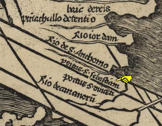
But if it really did not exist, then how does one account for its appearance on so many old charts? Are they all laid down on suppostition only, or is there some other explanation? To argue against the conclusions of FitzRoy and King, we can go back to Martin Waldseemüller's 1507 Universalis cosmographia … map of 1507. Note that the detail view shows a “Portus(?) S. Sebastiam” near the southern tip of South America. Years later, when Thomas Cavendish passed through the strait in 1586, he rescued one Señor Tomé Hernandez, a survivor of Pedro Sarmiento de Gamboa's failed attempts to establish settlements in the strait. Hernandez subsequently escaped and years later was questioned by the Spanish authorities who asked, among other things, if he knew of any entrances to the strait, beyond those already known? According to his recorded Declaration, he knew of none, but recalled something Cavendish had told him: there was indeed a mouth at a higher latitude—that is, south of the mouth at the narrows. If so, Hernandez noted that “… it would come out by an opening in the middle of the Strait.” In other words, it would “come out” into the present Bahía Inútil, which is just where the San Sebastián Channel would lead into the strait. It would be unlikely for Cavendish to “invent” such a tale, so it's reasonable to suppose he did indeed see this channel.
And then a century later (1681), a group of British buccaneers captured a Spanish ship bearing a priceless treasure: not silver, not gold, not jewels, but a “derrotero”—a volume of sailing directions and charts, one of which was of the Strait of Magellan. One of the buccaneers, Basil Ringrose, translated the Spanish sailing directions into English and, if a chart lacked an important label, he'd write one in English at the appropriate location, as shown here (rotated 90°, coloring added):
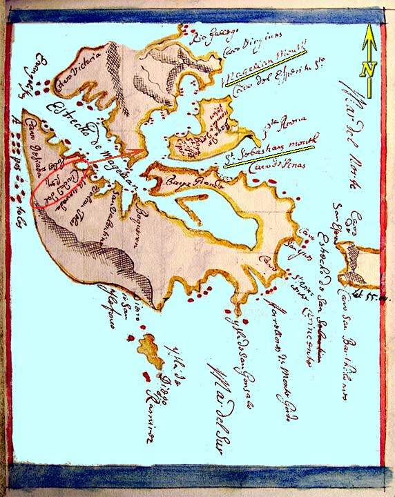
It appears Ringrose knew the de Nodal brothers had named the water separating Tierra del Fuego from Staten Island as the Strait of St. Vincent (see detail view of Rueda map below), as he has corrected the chart's “Estrecho de San Sebastian” by crossing out the last word and writing “Vincente” immediately below it. (Barely visible in the left illustration—see his edited chart of Tierra del Fuego for a better view.)
The detail view at right shows two other Ringrose additions: “Magellan Mouth” and “St. Sebastians mouth.” (The circled text is “Ciudad del Rey”—the City of King Felipe, misplaced from its actual location, but not corrected by Ringrose.)
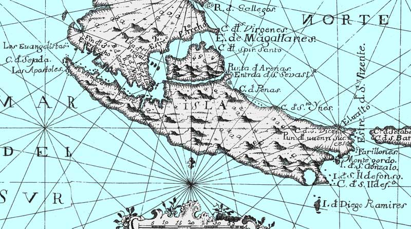
Now although this chart is certainly not the last word in accuracy, it was a working navigation tool for Spanish vessels and it does offer a reasonable (for the time) depiction of the Strait of Magellan, and of a second waterway connecting the strait with the Atlantic Ocean. Ringrose recognized it for what it was: the San Sebastián of the de Nodal brothers. Presumably he was familiar with the chart in the 1621 edition of their Relacion …, which showed the channel—quite similar to the chart by Manuel de Rueda in the second (1769) edition. The detail view below shows the channel on that chart. (See de Rueda, Manuel on the Maps page for the complete chart.)
Since the channel was on the charts in both of the de Nodal editions, and Ringrose knew its name, it would seem that it really did exist (but whether he saw it himself remains unknown).
In addition to the map in the de Nodal Relacion …, the authors even describe the channel in their text:
Saturday the 19th of January [1619], … at 11 we arrived at the channel of San Sebastián. We found 20 fathoms in it, clean bottom. On the north side it has a beach of white sand, 4 or 5 leagues in length. … It has a width of more than a league at the mouth. At this point [half way up the channel] the whole course of the channel is seen, as wide as at the entrance as far as it was visible, like a great sea. The altitude was taken in 53° 16.'
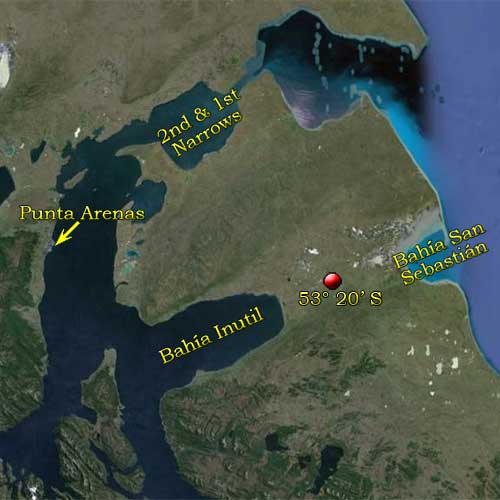
The de Nodals' description, distance measurements [a Spanish league was equivalent to 3 or 4 English miles] and altitude [read, latitude] agree with the modern Bahía San Sebastián, as shown in this Google Earth view. Although of course we don't know the actual width of the channel mouth, now that it's long gone. And in the “What a Coincidence” department, their entry for the next day begins:
Sunday the 20th of January, being the feast of San Sebastián, … .
Needless to say, the channel began appearing on many maps of Tierra del Fuego, such as the examples shown here:

And as further evidence of its existence, Sayer & Bennett's 1775 Chart of the Straits of Magellan shows the channel, below which the following note is seen:
According to the Description of Don Francisco Seyjas-y-Lobera, St. Sebastian's Channel communicates with the North Sea and is Navigable for small Vessels.
The reference is to Spanish Captain Francisco Seixas y Lovera's 1690 Descripcion Geografica, y Derrotero de la Region Austral Magallanica, in which the author stated that he had seen the San Sebastián canal, and received reports from others that it was navigable by small vessels.

[Click on image to enlarge.]
Sayer & Bennett, 1775
With all of the above submitted as evidence that it really did exist, why could neither King nor FitzRoy find it? The answer is simple: it really did not exist. That is, not at the time of their visits. At some time between the de Nodal and Beagle expeditions, the channel disappeared. But how then do we verify its early existence, and explain its recent disappearance? Charles Darwin does both:
On the eastern coast, of Tierra del Fuego, in latitude 53° 20' S., I found many Mytili§ on some level land, estimated at 200 feet in height.
and
St. Sebastian Bay … certainly existed previously to the last and smallest change of level, as [a] channel connecting the Strait of Magellan … with the open sea [that is, with the Atlantic Ocean — See Geological Observations … for the complete text].
§ A parasitic flatworm of fish and mussels. Darwin's 53° 20' S places the location between Bahías Inútil and San Sebastián, as shown on the Google Earth view below, and thus supports his view that the area was once a water passage between these bays. Google Earth shows the elevation as 225 feet.
As noted in Darwin's Journal and Remarks, his observation about the former water passage was omitted from the second (1845) edition of his Journal, but re-appeared the following year in his Geological Observations …, which also included his first mention of the Mytili discovery. And in that volume, his chapter title provides a clue to the fate of the channels: “On the Elevation of the Eastern Coast of South America.”§
§ See Note below for a few additional comments on Darwin at San Sebastián.
In other words, at the time of the de Nodals, the channel bed was below sea level and consequently connected the Strait of Magellan with the Atlantic Ocean. But that was in the seventeenth century, and by the time of HMS Beagle, gradual elevation of the land had already pushed the bed above sea level, and thus the channel was gone.
But is it really possible that all this could happen within hardly more than two centuries? At first, it might seem not, especially after reading Darwin's “Concluding Remarks on the Recent Elevation …,” beginning with a definition:
By the term ‘recent’ I refer only to that period within which the now living mollusca were called into existence.
His obscure explanation therefore defines “recent” as within the past 500 million years or so. Compared to that, the interval on the geological clock between 1619 and 1835 is an instant—in fact, far less than an instant—and might seem quite insufficient to encompass the elevations. But then Darwin suggests that some events do occur in less than an instant.
In 1835, a rocky flat off the island of Santa Maria [Chile] was at one blow upheaved above high-water mark, and was left covered with gaping and putrefying mussel-shells, still attached to the bed on which they had lived.
And, …
In Patagonia the movement [ie, the elevation] may have been by considerable starts, but much more probably slow and quiet.
But perhaps not always the latter. A considerable start—not slow, but perhaps quiet— may have done the job at San Sebastián in a century or two, give or take a few years.
Or even less than that—A bit of support for that possibility comes from Señor Julius Popper, who was active in the San Sebastián area near the end of the 19th century. The following report is a short excerpt from his 1887 “Exploration of Tierra del Fuego” lecture at the Argentine Geographical Institute.
The geological study of the Island reveals the fact that the land is rapidly rising. Extensive tracts, today covered with grass, formed at a comparatively recent period the bottoms of broad bays and wide canals, covered by the briny waves of the ocean.
… … … …
I verified the fact of the coast-line being three kilometres farther out than it was when Fitzroy visited it fifty years ago. A similar phenomenon of still more recent date is seen on the western shores of the Bay of San Sebastian.
I have mentioned some particulars in reference to this when treating of the meteorology. The waves of the ocean have also retired from this place, but the land has not yet had sufficient time to accumulate vegetable soil, and the clay appears just as it must have been when it was covered by the waters, the only difference being that the contraction produced by drying has formed a network of rifts and clefts, which by their symmetrical designs make the surface appear as if artificially ornamented.
Another proof which also reveals the pre-existence of a maritime canal that joined the Bay of San Sebastian to Useless Bay, consists in the erratic rocks which I met with in crossing this region. Some of these blocks measure fully eight cubic metres.
If Popper's account was reliable, the land in the San Sebastián area had been quietly rising at a rather fast rate for years. But is the channel truly gone now? Perhaps not, as this Google Earth view shows. The prominent inlets of Bahías Inútil and San Sebastián are almost “pointing” at each other. Just a coincidence, or were they once connected as the derrotero and the de Nodal map show?—and as Darwin states? As a hint, zoom in at the “?” icon. What do you see?
It should be pointed out that the charts shown above can't be taken as definitive evidence of the channel. Eighteenth-century map-makers were not above “borrrowing” details from those who had gone before, or of embellishing their charts based on little beyond their own imaginations. So, while Sayer & Bennett's notation that Seyjas-y-Lobera described the channel as “ … Navigable for small Vessels” sounds reliable, their depiction of the channel is less-than-reliable; embellished with an intricate network of channels throughout Tierra del Fuego. Neither Darwin nor anyone else spent (that is to say, wasted) much time looking for them.
 In closing, we are left with the unanswered question: Who gave the area the name of San Sebastián? The de Nodals generally followed the custom of naming a place in honor of the saint whose feast day it was on the day of arrival. (A day or two later they named a nearby cape: “As it was the day of San Vicente we gave it that name.”) But in this case they let it go that “…we arrived at …” San Sebastián, and one day later—having already departed the bay—“Sunday the 20th of January, being the feast of San Sebastián… .” Unlike San Vicente, they make no claim to having given the bay its name. And of course, the Portuguese “S. Sebastiam” on the 1507 Waldseemüller map seen here predates the de Nodals by more than a century. The same name appeared on a ca. 1502 chart by Nicolo de Canerio, also in Portuguese. So, the evidence (such as it is) suggests the name was bestowed by an early explorer—most likely Amerigo Vespucci—and was then passed along from one voyager to another, until eventually the channel dried up before the voyages of the Beagle.
NOTE: There is a fair amount of mis-information about Darwin's work in the San Sebastián area, which perhaps got its start in “Darwin's geological mystery solved” posted in October 2009 on the nature.com website. The lead paragraph states:
In June 1833, Charles Darwin asked the captain of the [sic, no “the” before HMS] HMS Beagle to delay his departure from Tierra del Fuego so that he could study a strange group of granite boulders he had found on the coast at Bahía San Sebastián.
Two months later (December 2009), the Geological Society of America's website posted Enigmatic boulder trains with a similar account:
In June of 1833, Charles Darwin delayed the progress of the [sic, same as above] HMS Beagle to better observe the boulders at Bahía San Sebastian, and in doing so, prompted the eventual satisfactory explanation for their existence.
In June, 1833, the Beagle was at Maldonado, Uruguay, some 1,400 miles from San Sebastián. And there is no known record of Darwin making such a request when he finally did arrive at San Sebastián in February, 1834. In fact, an entry in his Diary that month makes it quite clear that his time in the area was quite limited:
14th-21st During this week a complete survey has been made of the East coast of Tierra del Fuego. We landed only once, which was at the mouth of what was formerly supposed to be St Sebastians Channel, it now turns out only to be a large wild bay.
Notwithstanding the facts, the fiction has taken on a life of its own, with countless repetitions and variations now to be found on the internet.