Previous Galapagos IslandsContentsNotesSourceWhalesite Next

The Galápagos Islands

A History of Their Exploration

Title page

occasional papers no. xxv
of the california academy of sciences

Issued December 22, 1959

COMMITTEE ON PUBLICATION

Dr. Robert C. Miller, Chairman
Dr. Edward L. Kessel, Editor

DEDICATION

To Robert Cunningham Miller, Director of the California Academy of Sciences, whose interest in the project made its completion possible, this volume is gratefully dedicated

CONTENTS

page
Prefaceix
The Galápagos Islands1
Description of the Islands1
Water5
Introduced Animals7
Native Fauna7
Volcanoes9
Climate10
Discovery11
Origin17
Cartography18
Early Visitors27
Enderby Whalers52
Visiting Men-of-war and Sealers54
The United States Frigate Essex58
British Frigates Briton and Tagus73
His Britannic Majesty's Ship Beagle75
Voyage of Le Genie89
Voyage of the Corvette Decres101
Inhabitants105
The Galápagos “Post Office”108
Shipwrecks111
Expeditions to the Galápagos114
Air Base126
Tortoises127
Preservation of Galápagos Fauna135
Selected Bibliography140

PREFACE

      It is not the intention of the author to compile in the present work a complete bibliography of Galápagos literature, but rather to treat of the history of the islands from the time of their discovery to the present, bringing to light historical events and documents unknown to many Galápagos students as well as giving an account of some of the men and ships connected with their history.

      A selected bibliography, however, is appended for those who wish to make a serious study of the flora and fauna of these islands, or for those who merely wish to read of the numerous explorers and visitors before and after the memorable voyage of the Beagle.

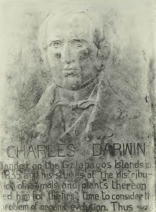
      Probably no other group of islands in the world has been the object of so much intensive study by the world's most distinguished scientists. It was amongst these now famous islands that Charles Darwin first formed his ideas as to the origin of species, and where he started on a career that made him one of the greatest naturalists of all time.

      The Galápagos have been one of the principal fields of endeavor of the California Academy of Sciences since its original expedition there in 1905-06, and its collections from the Galápagos Archipelago are unsurpassed.

      To enumerate all those who have assisted in compiling these data would make far too lengthy a list and to these my thanks are due. There are, however, those to whom I am especially indebted and without whose help the project would have been impossible: The Reverend Padre Emilio del Sol, of the Church of Santa Maria del Mercado, Berlanga, Spain, furnished the photographs of the burial place and wood carving of Fray Tomas, the discoverer of the Galápagos; Captain H. J. Hennessy and Commander W. E. May of the Royal Navy on duty at the Admiralty were most helpful, as well as the Imperial War Museum and the Maritime Museum which supplied naval photographs and prints; the British Museum Library allowed the use of old maps and diaries and the Public Records Office the data from the various old logs and letters; Mr. H. W. Parker, of the British Museum of Natural History, extended many personal courtesies; Rear Admiral Francisco Benito Perera, of the Spanish Navy, and Captain Proctor Thornton, U.S.N. (Ret.), have been most helpful in securing data regarding the early Spanish ships; the Pennsylvania Historical Society very kindly allowed the use of the Feltus diary; Dr. Paul Chabanaud, of the Museum d'Histoire Naturelle, Paris, France, secured the reports of the French vessels of war, Le Genie and Decres,

ix

from the French Admiralty; Dr. F. X. Williams, formerly with the Hawaiian Sugar Planters Association, sent much information regarding the early whalers. Also, I wish to thank especially Miss Veronica Sexton, Librarian of the Academy, who was most solicitons in attending to many requests, and Mrs. Lillian Dempster, of the Department of Ichthyology, for translating the many Spanish letters connected with the research.

      Last, but not least, I feel deeply indebted to Mrs. Barbara Gordon, of the Academy's television staff, who so painstakingly typed the manuscript.

The Author1     


      1 [Joseph Richard Slevin. for more than fifty-three years associated with the California Academy of Sciences in its Department of Herpetology, passed away February 15, 1957, in his seventy-sixth year. He first visited the Galápagos Islands in 1905 as a member of the Academy's Galápagos Expedition. From that date until the time of his death, he maintained an active interest in those islands and published a number of scientific and popular papers about them. The manuscript for the present paper was completed shortly before his death. – Editor.]

x

THE GALAPAGOS ISLANDS

      The Galápagos Archipelago, or Archipielago de Colón as it is called by the Government of Ecuador, was annexed by that country on February 12, 1832. The history of these islands remained more or less obscure to the world for many years after their discovery as they had no strategic value in the scheme of events until the construction of the Panama Canal. Then at once they became of the greatest importance to the United States as a base for the protection of that waterway in time of war, and were used as such in World War II. Any mention of a plan to lease or purchase them by the United States immediately brought a storm of protest from all Latin America and it was impossible to come to any terms with the Government of Ecuador for permanent occupancy.

      The archipelago, consisting of some fifteen islands and numerous islets and rocks, extends from Latitude 1°40' N. to 1°36' S. and from Longitude 89°16'58" to 90°1' W., the nearest point to the mainland being Mt. Pitt on Chatham Island, which is 502.5 miles N. 87°50' W. of Marlinspike Rock, Cape San Lorenzo, Ecuador. The equator passes through the northernmost volcano of Albemarle Island.2

      The islands themselves are in reality immense lava piles projecting out of the ocean, some with perfectly formed craters, and there are hundreds upon hundreds of minor ones together with fumaroles and vents scattered over the landscape. Great lava flows extend from the crater rims to the sea. These, the most striking features of the landscape, vary greatly, some being composed of huge black or brown slabs that have the appearance of age, while others are rough, black boulders that appear to be of recent origin, so much so that one would think they had hardly cooled.


Description of the Islands

      Albemarle, shaped somewhat like a boot, is the largest of the group, being approximately seventy-five miles in length and forty-five in breadth at the southern end, the widest part. Narborough, James, Indefatigable, Chatham, Charles, Bindloe, Abingdon, Tower, and Hood are next in size and importance, while the remainder range from islets of a mile or less to mere rocks.


      2 [The author has used the English names for islands and localities throughout his manuscript which was prepared from the English viewpoint and is published in connection with the Darwinian Centennial year of 1959. Most of these names are not official inasmuch as they have been replaced with Spanish names by the Government of Ecuador. See pages 25-26 for a list of alternatives. — Editor.]

[1]

2 CALIFORNIA ACADEMY OF SCIENCES [Oc. Papers

      The mountains of the Galápagos are best represented on Albemarle and Narborough islands, the former having five large volcanoes, the broadest of which, Villamil Mountain, is 4,890 feet. The crater, somewhat oval in shape, is approximately five miles in diameter, and the area about the rim is open country with a scattering of small trees. As it is often covered with clouds, there is considerable moisture, resulting in a luxurious growth of grass furnishing marvelous grazing land for the wild cattle which range about the southern slope above the tree belt. The base of the mountain is surrounded by barren lava beds.

      Iguana Cove Mountain, 5,540 feet in height, is of a somewhat different type. The southern slopes, being exposed to the prevailing southerly winds, are covered by a dense growth of vegetation from the crater rim to the shoreline, while the northern ones are barren. The line of demarcation between lava flow and vegetation is so remarkably distinct that it is the first thing that strikes the eye while sailing along Albemarle's western coast.

      Cowley Mountain, 3,650 feet in height, is of still another type, the lower slopes being covered by pumice with a very scant growth of vegetation up to the vicinity of the crater rim. Here a wide belt of sword grass forms an impenetrable barrier surrounding the crater rim.

      The two northern mountains, Tagus Cove, 4,300 feet, and Banks Bay, 5,500 feet, are much more barren in appearance, although there is sparse vegetation at their lower levels. Neither of these mountains is as spectacular as are the southern ones, though like them they have well-formed craters.

      Narborough, a huge mountain of lava, is no doubt the most barren and least known of the larger islands, the greater portion of it being a series of black lava flows with only small streaks of vegetation showing on the steep eastern slope, while the southwestern slope, which is exposed to the southerly breezes, shows considerable vegetation despite the most violent eruptions that have taken place. The island rises to a height of about 4,500 feet and has a lake in the crater floor which in turn has a small crater with a lake of its own. As no anchorages were marked on the earlier charts, its waters were given a wide berth by navigators in general and landings were made from small boats while the vessel hove to off shore or lay at anchor in Tagus Cove across the strait. Mr. Templeton Crocker's yacht Zaca, while on an expedition for the California Academy of Sciences, was the first vessel to chart an ancliorage on Narborough. It was named California Cove.

      The great lava flows of Albemarle and Narborough vary considerably in character, some being composed of huge black or brown

No. 25] SLEVIN: THE GALAPAGOS ISLANDS 3

Fig. 1

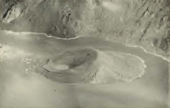
Fig. 1. Aerial view of the crater of the Narborough volcano, showing its lake which surrounds a secondary crater which has a lake of its own. Photo courtesy of Captain Paul P. Lila, U.S.A.A.F.


slabs that have the appearance of great age; others appear to be of very recent origin.

      Two small islands of a distinct type, Duncan and Tower, have well-formed craters, the former with its lava flows covered with lichens, giving the appearance of great age. Its crater floor is composed of red volcanic ash. Tower Island, by contrast, is composed of black lava and has a crater lake of brackish water.

      The other larger islands, Indefatigable, James, Chatham, Charles, and Hood, are all of a somewhat different type, the main craters having broken down to the extent that they are no longer well deflned, or even visible. The tops of all except Hood, which is a very low island only about 650 feet in height, are covered with vegetation, and Chatham and Charles have open areas in the vicinity of their summits.

      On a visit to Charles Island in 1928, much of the open area found in 1905 had been encroached upon by a lemon thicket on top of the central plateau so that the open area had practically disappeared; no doubt the landscape changes from time to time and descriptions may not remain applicable.

      The tops of all the islands and of all the volcanoes have now been reached on foot by some or several members of the Academy's various expeditions.

4 CALIFORNIA ACADEMY OF SCIENCES [Oc. Papers

      Mr. Rollo H. Beck, chief of the Academy's expedition of 1905-06, climbed to the top of Narborough and reported seeing the lake in the crater now shown on H. O. Chart No. 1798 from the survey of the Galápagos made by the U.S.S. Bowditch in 1942.

      The top of Indefatigable was reached by the members of the Templeton Crocker expedition to the (lalapagos Islands in the interests of the Academy, and Mr. John Thomas Howell, the Academy's Curator of Botany, gave an excellent description of the ascent in the Sierra Club Bulletin, volume 27, number 4, August, 1942.

      When the United States Army established its air base in the Galápagos, much of the area was photographed from the air. From these aerial surveys it was possible to make additions and corrections to the survey of 1835, which was in use until it was replaced by the U.S.S. Bowditch survey. Among the changes made were the listing of the crater lake on Narborough and the dropping of the supposed central crater on Indefatigable Island. The need for this addition and cor-
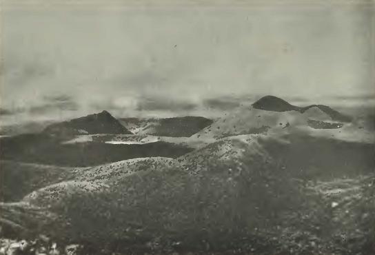
Fig. 2

Fig. 2. On Tuesday, August 10, 1932, members of the Crocker Expedition to the Galápagos Islands conquered Indefatigable and were the first to see the highlands from the highest point on the island.
      Looking in a southeasterly direction from the remnant of a crater rim, the highest point on Indefatigable Island, 2835 feet above sea level. The chief correction made in the chart of the U.S.S. Bowditch (1942) was the omission of a great central crater which had been shown for this island on the chart of H.M.S. Beagle (1835).

No. 25] SLEVIN: THE GALAPAGOS ISLANDS 5

rection first became known through the Academy's explorers who conquered the mountains on foot and were the first to see the crater lake of Narborough and to give a proper description of the top of Indefatigable. The latter island had defied several attempts to reach its summit.


Water

      For all visitors to the Galápagos, water seems to have been one of the greatest problems, and from the accounts of the early navigators they spent much time in search of it, mostly with little success. On rare occasions, when a copious rainfall occurred, a few depressions in the lava beds or the bottom of the arroyos were found to contain small amounts of water, but a generous supply where a ship could be watered from along the coast is not existent. There is one spot, how-
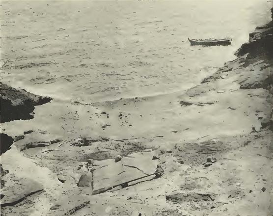

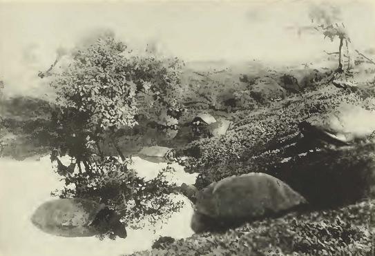
Fig. 3

Fig. 3. This waterhole, about half a mile south of Tagus Cove, Albemarle Island, was found to be full by Captain Amaso Delano on August 21, 1801, and he watered his ship Perseverence from it over one hundred and four years before the Expedition of the California Academy of Sciences to the Galápagos Islands replenished the water supply of the schooner Academy from the same hole. A tarpaulin was thrown over the hole to help keep out the dust. The water was bailed out into a breaker or barrel, rolled to the water's edge and into the sea, and then parbuckled into the skiff.

6 CALIFORNIA ACADEMY OF SCIENCES [Oc. Papers

ever, on the east coast of Chatham Island (Freshwater Bay) which might have saved many an early visitor from a shortage of water if it had been discovered. A small stream trickles down from some permanent ponds on the plateau and finds its way to a basin in the rocks just above the tide line. It is this basin that was pictured in a drawing made by Midshipman G. W. P. Edwardes of H.M.S. Daphne shown at the bottom of his chart of Freshwater Bay, surveyed during the visit of that vessel to the Galápagos in 1836.

      On Albemarle Island, just above half a mile south of the mouth of Tagus Cove, a small basin in the tufa collected about forty to fifty gallons per day from underground seepage, and the Academy's expedition of 1905-06 watered the schooner from this basin while at anchor in Tagus Cove. It is not certain, however, whether the underground flow can be relied upon throughout the year. Again at the southern end of the island, at Villamil anchorage, some waterholes three or four miles inland furnish a moderate supply of water which, although drinkable, has a strong taste of sulphur. The grasslands about the top of the mountain have waterholes with a constant supply of good drinking water, but of course this is an impossible source as far as watering a ship is concerned.

      Chatham Island also has good fresh water in some parts of the plateau and water can be hauled down by ox team in case of necessity, though it is not a very practical method of watering a ship.

      The plateau of Charles Island, like Chatham, also has good drinking water in some springs near the base of the main peak, but the supply is not nearly as plentiful as that of Chatham.

      During the rainy season, at the northern end of James Bay on James Island and about opposite Albany Island, water collects in some depressions in the lava. It was here that the buccaneers invariably searched for water and, at times, found it in small quantities as they did in similar places elsewhere on the larger islands.

      No one need die of thirst in the higher portions of Indefatigable as the summit of that island is covered practically daily by clouds which create sufficient moisture to fill depressions in the lava and make possible its dense vegetation. Again, however, this does not help the thirsty mariner at the shoreline.

      A casual investigation of the Galápagos coastline will at once suffice to show the visitor why the water problem of the early voyagers was a major one.

No. 25] SLEVIN: THE GALAPAGOS ISLANDS 7

Introduced Animals

      Of late years, owing to the activities of tuna boats and various yachts which have called at the islands, it is difficult to tell what domestic animals have been introduced and on what islands. It is known, however, that rats occur everywhere and that with the exception of pigs and cats on Indefatigable, which are a comparatively late importation, the islands listed have been inhabited as follows:


Albemarle Chatham South Seymour
dogs dogs goats
cats cats
cattle cattle
burros burros
Barrington Hood Indefatigable
goats goats dogs
cats
burros
pigs
Charles James
dogs goats
cats burros
goats
cattle
pigs
burros

Native Fauna

      While the neighboring continent of South America, only 500 miles away, harbors birds of the most gorgeous plumage in its tropical forests and has a varied and wonderful mammal population, the avifauna of the Galápagos is most sombre, the little crimson flycatcher and the beautiful pink flamingo giving the only touches of real color.

      Of the Galápagos fauna, the gigantic land tortoises from which the islands get their name, galápago being the Spanish for tortoise, naturally claim first attention. These huge and grotesque reptiles have been found living in no other place in the world except the islands off southeast Africa where they no longer exist in the wild state as they do in the Galápagos. Whether the Galápagos tortoise can survive is a question. In the past they furnished a ready supply of fresh meat for the early voyagers, especially for the whalers who frequented

8 CALIFORNIA ACADEMY OF SCIENCES [Oc. Papers

the Pacific, as the waters around the Galápagos were one of their favorite cruising grounds. Tortoises were removed by the thousands during the long period of the whaling activity which started in the early 1790's and continued without decline until the 1860's. At the present time these tortoises are hard pressed by their enemies, the wild dogs being the worst if we except man. While the dogs kill the fully grown tortoises, the rats and hawks destroy the young as soon as they hatch from the egg, so that the percentage of survivors from a nest is undoubtedly small. Certainly the tortoise has an uphill battle to survive and is barely holding its own. The land iguana, formerly living in large colonies on James, Indefatigable, and Albemarle islands, is extinct on the two first and very scarce on the last, a few scattered ones still surviving at the north end of Albemarle where the dogs, owing to the extreme roughness of the terrain, have not penetrated to any great extent. Colonies on Barrington and South Seymour [Baltra], the other islands they are known to inhabit, have been successful in surviving, man being their worst enemy.

      The sea iguana, found nowhere else in the world, is unique in that it is the only reptile known that depends solely on the sea for its food. This inhabitant of the Galápagos is abundant and is probably the native species that stands the best chance for survival. Living along the rocky coasts where their food, a species of sea lettuce, is found, they can take to the water and swim to outlying rocks for safety, their only risk that of being caught by a shark while en route. A great danger, however, which these iguanas have to face is that of having their nests destroyed by dogs, rats, or pigs.

      Excluding a species of sea snake, which has been seen in Galápagos waters, and is of course venomous, a few species of lizards and harmless snakes complete the reptile fauna.

      Bird life is abundant on the islands and there are various types of land birds, such as hawks, owls, and flycatchers, together with the little finches that so excited Darwin's curiosity. Among the water birds are ducks, herons, and the beautiful pink flamingos which are found in the lagoons along the coasts. Like many other isolated islands, the Galápagos furnish nesting sites for thousands upon thousands of sea birds. One of these, the flightless cormorant, like the sea iguana is found nowhere else in the world.

      Tiie mammal and insect faunas, to say the least, are both inconspicuous, the former consisting of a bat and a few species of rodents, some of which may recently have been eliminated because of their inability to compete with introduced rats. The insect fauna consists of various types of beetles and the like, together with a few species of

No. 25] SLEVIN: THE GALAPAGOS ISLANDS 9

butterflies and hawk-moths, not one of which attains the beautiful coloring- of many of the species on the adjacent mainland.

      Native faunas tliroughout the world are having a struggle to survive and that of the Galápagos is not an exception. Besides having to contend with man for four hundred years and more, natural and introduced enemies make survival so precarious that even though the government of Ecuador has wisely made the archipelago a wildlife refuge, it is a question whether much of its native animal life will survive. It may be that the small land birds will go completely, as the cats increase, just as some species have done in other places, for example on Guadalupe Island off Baja California, Mexico.


Volcanoes

      The Galápagos are certainly a land of fire, but whether the Inca Tupac Yupanqui ever saw the legendary Nina-Chumbi, island of fire, no one knows. Various early voyagers were greatly impressed by the great volcanoes and invariably mention them in the accounts of their travels.

      In 1801, Amasa Delano observed, from his anchorage at James Bay, a remarkable eruption of one of the mountains of central Albemarle. Probably the greatest eruption ever seen, however, was that observed by Captain Benjamin Morrell of the sealing schooner Tartar when the main crater of Narborough erupted in February, 1825. His vessel was anchored in Banks Bay when at 4:30 a.m. the molten lava started pouring over the rim of the crater forming a river of liquid fire that flowed to the sea. By 11 a.m. the temperature reached 113°F. and that of the water 100°. The eruption continued and the situation of the vessel became perilous, though she was anchored some ten miles to the northward of the volcano. The heat, however, was so great that pitch in the vessel's seams melted and the tar dropped from the rigging. The following day, several of the crew complained of faintness when the temperature rose to 123° and the water to 105°.

      Fortunately, a light easterly breeze sprang up at 8 p.m., the anchor was hoisted, and the Tartar was able to make its way through the channel between Albemarle and Narborough islands, thus saving itself from a catastrophe. While passing through the strait, the thermometer rose to 147° and the water to 150°. By 11 p.m. the schooner anchored at the southern end of Elizabeth Bay, but as the volcano continued to erupt the heat became so intense that the anchorage was abandoned. The Tartar was still within sight of the volcano almost two weeks from

10 CALIFORNIA ACADEMY OF SCIENCES [Oc. Papers

the start of the eruption, and though the violence had subsided, the volcano was still active. This was probably as great an eruption as any ever seen by man. Narborough seems to be a particularly active volcano as Lord Byron, while at Tagus Cove on H.M.S. Blonde, observed an eruption just the year before (1825).

      Many late visitors have reported seeing minor craters active. A British naval officer. Captain Donald McLennan, in command of the brig Colonel Allan, who sailed from Grovesend on August 19, 1817, for the South Seas, stopped at the islands and mentioned "there are several volcanos on the Islands that are occasionally seen to burn with great fury, one of which was seen by the Colonel Allan on her last voyage, about two years since, the flames from it rose to a great height and was seen at the distance of several leagues."

      Captain McLennan also saw several of the minor craters of Albemarle in eruption.

      On the expedition of the California Academy of Sciences in 1905-06, many fumaroles were seen, and Bindloe, Abingdon, James, and the great crater of Villamil ^Mountain were all spouting steam. Dr. William Beebe, in 1925, witnessed a minor crater in eruption near Cape Marshall, Albemarle, as did Captain Lackey of the U.S.S. Memphis in 1938 and Templeton Crocker's yacht Zaca in 1933. On the voyage of Captain Allan Hancock's Oaxaca in 1937-38, a spectacular eruption of a minor crater in southeastern Narborough was observed, the molten red lava pouring into the sea, discoloring the water and killing thousands of fish. Volcanic activity is more apt to be seen in northern Albemarle and on Narborough where secondary craters are numerous. Of late years, not a single one of the main craters has shown any signs of recent eruptions with the exception of the Villamil Mountain crater, where a jet of steam has been in evidence for many years. It is here that a small sulphur deposit, claimed to be of a very high grade, has been worked at intervals.


Climate

      Though the Galápagos are situated directly on the equator, which would lead one to suppose that temperatures might be excessive, the islands have a delightful climate, the thermometer rarely going above 80°F. The Humboldt Current, sweeping up from the south, turns westward when it reaches the Ecuadorian coast and, passing through the southern group of the Galápagos, bathes their shores with the cool waters of the Antarctic, creating an ideal climate. The Panama Cur-

No. 25] SLEVIN: THE GALAPAGOS ISLANDS 11

rent, which is several degrees warmer, encircles the northern group of islands, but these, too, have a climate that is delightful.

      The seasons are variable and uncertain, but spring may be considered as the period between January and June, while July to December may be considered the dry season, although at high elevations, which are usually covered with clouds, there is considerable moisture. Dampier (1864) found rains in November-December and January and fair weather in May-June-July-August.

      The prevailing southeasterly winds support vegetation on the higher elevations and in some cases, as at Iguana Cove, it extends to the beach line. Despite the tremendous eruptions that have taken place on Narborough Island, there is a considerable green zone on the western slopes.


Discovery

      Whether the Inca king, Tupac Yupanqui, who is credited by Sarmiento with having discovered the Galápagos Islands, really did so is a question. As the Incas possessed no written language, the story of the voyage of the Inca king is purely legendary.

      The compilation of the Inca history entrusted to Captain Pedro Sarmiento de Gamboa, cosmographer of Peru, by Don Francisco de Toledo, viceroy, governor, and captain general of the kingdom of Peru, is from information given by the Inca descendants who were called upon to give testimony to the traditions handed down by their ancestors and which were supposed to have been learned by heart.

      The story of some merchants coming from western seas and giving glowing accounts of the land from whence they came, reached the ears of Tupac Yupanqui, an ambitious man who was not satisfied with the lands in his possession but longed for further conquests. To assure himself that the merchants of the West were giving a truthful account of their voyage, he called upon Antarqui, renowned for his magic powers, to give an opinion as to their truthfulness. Having assured the Inca king their stories were true, Antarqui set out to prove it by making the voyage to the west himself and came back with remarkable tales of his exploration. Thus assured, Tupac Yupanqui is said to have embarked with some twenty thousand men on a fleet of rafts leaving, according to Miguel Cavello de Balboa, from the coast of Manta near Guayaquil on a voyage which lasted more than a year. As the legend goes, Tupac Yupanqui sailed on and on until he discovered two islands which he named Nina-Chumbi (island of fire) and Hahua-Chumbi (outer island). These, Cavello says, may have

12 CALIFORNIA ACADEMY OF SCIENCES [Oc. Papers

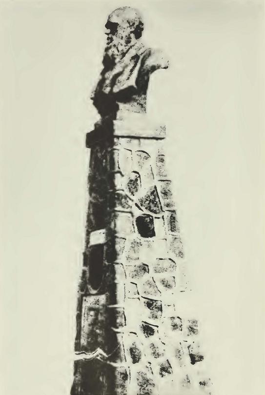
Fig. 4

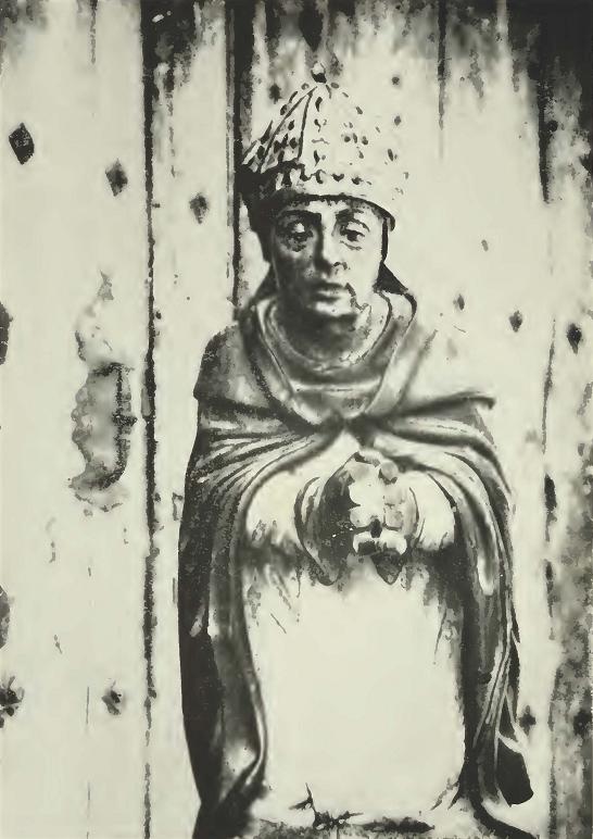
Fig. 4. The Very Reverend Fray Tomás de Berlanga, Fourth Bishop of Panama and discoverer of the Galápagos Islands. (From a wood carving in the Church of Santa Maria del Mercado, Berlanga, Spain.)

No. 25] SLEVIN: THE GALAPAGOS ISLANDS 13

been two of the Galápagos. Upon the return from his voyage, which is supposed to have taken phice sixty years or so previous to that of Fray Tomas de Berlanga, it is stated he brought back the skin and jawbone of a horse. The Spaniards state, however, that the horse was unknown to the Indians of the New World until 1519, when Hernando Cortes landed at Vera Cruz to begin his march on the capital of the Aztecs, at which time he brought some sixteen horses to be used for cavalry mounts.

      Of course, it is well known that the early navigators did make voyages on various types of rafts rigged with sails and rudders, or centerboards which acted as such, but to transport an army of twenty thousand men over seas and be out for more than a year seems rather improbable.

      History records the discoverer of the Galápagos as Fray Tomás de Berlanga, the Bishop of Panama. He was born in Berlanga, Spain (the date uncertain), and died in the town of his birth in 1551, being buried in the Capilla del Obispo de Panama o de los Cristos of the Colegiata de Berlanga.

      Admitted to the Dominican Order at San Esteban de Salamanca in 1508, he obtained at Rome in 1528 the establishment of a separate province named Santa Cruz, of which he was made provincial in 1530. His territory included all lands so far discovered and to be discovered on the west coast of South America, so the then unknown Galápagos Islands came wdthin his jurisdiction. In 1533 Fray Tomás succeeded the Franciscan Friar Marti Bejar and became the fourth Bishop of Panama.

      Spanish conquests in the New World now saw the Empire of the Incas fall to Pizarro and his lieutenant Diego de Almagro, who extended their conquests farther southward bringing more territory into the diocese of Bishop Tomás.

      Eumors of dissension between the conquerors having reached the ears of Emperor Carlos V, he issued a decree dated July 19, 1534, giving the power to Fray Tomás de Berlanga to arbitrate any dispute between them and ordering the bishop to Peru on his mission. Leaving Panama on February 23, 1535, his vessel was caught in one of the calms so prevalent in those regions, and the equatorial current, setting his vessel to the westward, carried him out to the Galápagos. His letter to his Emperor is the first document ever written pertaining to them. This most interesting letter, a translation of which follows, contains the first mention of the giant land tortoises inhabiting the Galápagos and from which the archipelago gets its name, the tameness of the

14 CALIFORNIA ACADEMY OF SCIENCES [Oc. Papers

Fig. 5

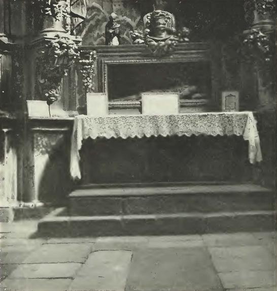
Fig. 5. Capilla del Obispo de Panama o de los Cristos, burial place of Fray Tomás. The large slab of dark slate at the foot of the altar covers the tomb.


birds which has been remarked upon by most all visitors thereafter, and the grotesque iguanas which constitute another remarkable feature of a most unique fauna. Little did the reverend bishop know that he had discovered a zoological paradise that was to claim the attention of the world's leading scientists for well over a hundred years and which still continues to do so.


Puerto Viejo, April 26, 1535.     

Sacred Imperial Catholic Majesty:

      It seemed right to me to let Your Majesty know the progress of my trip from the time when I left Panama, which was on the twenty-third of February of the current year, until I arrived in this new town of Puerto Viejo.

      The ship sailed with very good breezes for seven days, and the

No. 25] SLEVIN: THE GALAPAGOS ISLANDS 15

pilot kept near land and we had a six-day calm; the currents were so strong and engulfed us in such a way that on Wednesday, the tenth of March, we sighted an island; and, as on board there was enough water for only two more days, they agreed to lower the life-boat and go on land for water and grass for the horses, and once out, they found nothing but seals, and turtles, and such big tortoises, that each could carry a man on top of itself, and many iguanas that are like serpents.

      On another day, we saw another island larger than the first, and with great sierras; and thinking that on account of its size and monstrous shape, there could not fail to be rivers and fruits, we went to it, because the distance around the first one was about four or five leagues and around the other, ten or twelve leagues, and at this juncture the water on the ship gave out and we were three days in reaching the island on account of the calms, during which all of us, as well as the horses, suffered great hardships.

      The boat once anchored, we all went on land, and some were given charge of making a well, and others looking for water over the island; from the well there came out water saltier than that of the sea; on land they were not able to find even a drop of water for two days and with the thirst the people felt they resorted to a leaf of some thistles like prickly pears, and because they were somewhat juicy, although not very tasty, we began to eat of them and squeeze them to draw all the water from them, and drawn, it looked like slops, or lye, and they drank of it as if it were rose water.

      On Passion Sunday, I had them bring on land the things necessary for saying Mass, and after it was said, I again sent the people in twos and threes, over different parts. The Lord deigned that they should find in a ravine among the rocks as much as a hogshead of water, and after they had drawn that, they found more and more. In fine, eight hogsheads were filled and the barrels and the jugs that there were on the boat, but through the lack of water we lost one man and two days after we left the island we lost another; and ten horses died.

      From this island we saw two others, one much larger than all, which was easily fifteen or twenty leagues around; the other was medium; I took the latitude to know where the islands were and they are between half a degree and a degree and a half south latitude. On this second one, the same conditions prevailed as on the first; many seals, turtles, iguanas, tortoises, many birds like those of Spain, but so silly they do not know how to flee, and many were caught in the hand. The other two islands we did not touch; I do not know their character. On this one, on the sands of the shore, there were small stones, that we stepped on as we landed, and they were diamond-like stones and others amber colored; but on this whole island, I do not think that there is a place where one might sow a bushel of corn, because most of it is full of very big stones, so much so, that it seems as though some time God had showered stones; and the earth that there is, is like dross, worthless, because it has not

16 CALIFORNIA ACADEMY OF SCIENCES [Oc. Papers

the power of raising a little grass, but only some thistles, the leaf of which I said we picked. Thinking that we were not more than twenty or thirty leagues from this soil of Peru, we were satisfied with the water already mentioned, although we might have filled more of our casks; but we set sail, and with medium weather we sailed eleven days without sighting land, and the pilot and the master of the ship came to me to ask me where we were and to tell me there was only one hogshead of water on the ship. I tried to take the altitude of the sun that day and found that we were three degrees south latitude, and I realized that with the direction we were taking, we were becoming more and more engulfed, that we were not even heading for land, because we were sailing south; I had them tack on the other side, and the hogshead of water I had divided as follows: half was given for the animals, and with the other half a beverage was made which was put into the wine cask, for I held it as certain that we could not be far from land, and we sailed for eight days, all of which the hogshead of the beverage lasted, by giving a ration to each one with which he was satisfied. And when the hogshead gave out and there was no relief for us, we sighted land and we had calm for two days, during which we drank only wine, but we took heart on sighting land. We entered the bay and river of the Caraques on Friday, the ninth of April, and we met there the people of the galleon from Nicaragua, who had left Nicaragua eight months before, so we considered our trip good in comparison with theirs.

      The bay of the Caraques is at half a degree south latitude and on the maps it is three degrees; from this bay to Puerto Viejo it is nine leagues along the sea-coast; and the said bay is one of the most beautiful ports that there can be in the world, and the boats can moor there, and they can sail up it three or four leagues and they do not know whether any more. Commander Pedro de Alvarado landed here and destroyed a town of Indians that was there and frightened others; and it is a pity to see the havoc wherever he went with his men.

      From this bay I landed with the passengers and we set out on foot, because our animals were worn out from coming to this town from Puerto Viejo, and walking, we came to a valley which is called Charapoto, which has a very good river, where there are many Indians now peaceful, because Captain Francisco Pizarro has behaved so well that he is at peace with about thirty chiefs. This captain and lieutenant governor is so well looked upon by them that they bring him food of corn and fish and venison, and whatever is necessary, and if by chance when they go to see some land they capture some Indians, they immediately return them to their native soil and they give them a cross, so that on account of it no Spaniard will do them any harm, and that any one who wants to come to see it should bring some sign and that way no harm will be done to them. If he learns that any gold or silver is taken from them, he immediately has it returned to them, and some of them have brought it to him

No. 25] SLEVIN: THE GALAPAGOS ISLANDS 17

and he tells them that he has not come for their gold or their silver, hut rather so that they may know God and your Majesty, and that your Majesty will give them masters, who will have charge of teaching them the things of the Holy Catholic Faith, and that, on account of their solicitude, they must undertake to feed them. The keeping of this Captain seems to me very very good for the serving of Our Lord and Your Majesty, and for relieving your royal conscience; and since he has a great thing to do, I have told him your Majesty's intention in this matter, and he is determined not to deviate from it very soon.

      There are great gold mines, and here I have the information from those who were with Alvarado, that six leagues from this town there are very good gold mines. There is thought to be a bed of emeralds, because the Indians have them in their jewelry; ordinarily the said Indians have their touches and points and some of them of very great qualities. It is thought that before half a year a good part of this land will be peaceful, owing to the good treatment given them by the already mentioned captain and lieutenant; and your Majesty should support him in it, and it is necessary considering the importunities of the men that he has, because they follow with longing eyes every trace of gold that they see.

      God willing, I shall leave for the town of San Miguel in four days. The whereabouts of the Governor, Don Francisco Pizarro, is not known at present. He is quite far from here, although some think and they said that he is coming to the Town of Truxillo, which is between San Miguel and Xauxa.

      The Lord fill Your Sacred Majesty with holy love and grace for many years and with the conservation of your realms and an increase of other new ones as I hope. From this new town of Puerto Viejo, the twenty-sixth of April, in the year fifteen hundred and thirty-five. I am Your Sacred Imperial Catholic Majesty's most true servant and subject and perpetual Chaplain who kisses your royal feet and hands. Fray Tomas eps. Locastelli Auril.


Origin

      The origin of the Islands is still a question of debate. Whether they are oceanic islands thrust up from the ocean bed or whether they were formed by subsidence has claimed the attention of the most renowned naturalists and geologists from the time of Darwin's voyage on the Beagle to the present day. When Darwin, Baur, Agassiz, and many other scholars pursued their studies, they did not have the advantage of those who came after them, being entirely unaware that Pliocene fossils existed on certain of the islands; nor did they have the flora and fauna at hand that enabled later students to draw their conclusions.

18 CALIFORNIA ACADEMY OF SCIENCES [Oc. Papers

      There were two distinct schools of thought on the subject. Such noted scientists as Darwin, Wallace, Agassiz, Wolf, and many others were strong advocates of the oceanic theory, while Ridgway, Gadow, Van Denburgh, Barbour, and Baur were in favor of subsidence.

      It was, however, more or less a general opinion amongst many that there was a Galápagos land mass extending much closer to the coast than the islands do today, but not necessarily a direct connection with the mainland.

      The late Dr. John Van Denburgh of the Academy's staff made an exhaustive study of the reptiles and came to the conclusion that at one time there was a Galápagos land mass that gradually broke up to form the present archipelago. Remarkably enough, he thought that Duncan Island, which shows signs of great age, was an island in a crater-like bay before the islands surrounding it were actually separated from each other. A parallel case in miniature is taking place today, the crater of Narborough containing a lake with a small crater near its center, which in turn contains a small lake.


Cartography

      The position of the Galápagos was fairly well known to the early navigators. Bishop Tomás, while on his voyage from Panama to Peru, took the latitude and placed the islands as being between half a degree and a degree and a half south of the equator, so he was not far off in his calculations as the main portion of the archipelago does extend 1°25' south of the equator. The islands appear on Ortelius' Theatrum Orbis Terrarum, published at Antwerp in 1570, as "Insulae de los Galopegos," and in his Peruviae Auriferae Regionis Typus, of 1574 they are named "Isolas de Galapágas" and are represented as one island with two adjacent islets.

      The Jesuit Father Matteo Ricci's Chinese Maps of the World ( 1584-1608) show an area labeled "South Seas" and a group of islands in the approximate position of the Galápagos, though no name is given them.

      The early navigators placed them about two degrees to the westward of the 80th meridian, but Dampier, one of the early buccaneers, claimed they were farther to the westward, and in this he was correct as the main portion of the archipelago lies west of the 90th, and all of it to the westward of the 89th meridian.

      While the Galápagos appeared as early as 1570 on the chart of Abraham Ortelius, as well as on other charts by various cartographers

No. 25] SLEVIN: THE GALAPAGOS ISLANDS 19

at later dates, no attempt was made to attach individual names until William Ambrose Cowley made his chart of 1684 and Captain Colnett made his in 1793-1794. They were named mostly after the English kings, admirals, the nobility, buccaneers, and early visitors to the islands.

      After 1570, the islands appeared on many maps of the early cartographers. A map drawn by Guilielmus Hack, in 16S4, shows the
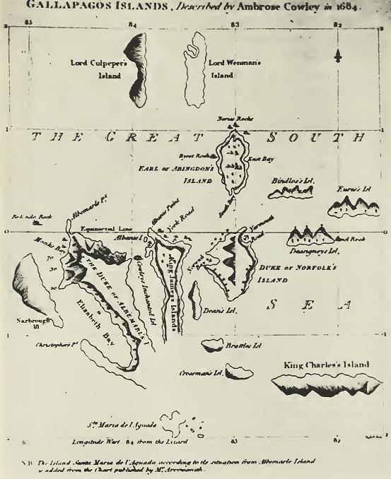

Fig. 6

Fig. 6. First chart of the Galápagos Islands, made by Ambrose Cowley in 1684. He also made enlarged drawings of many of the islands, two of which are shown in figures 7 and 8.

20 CALIFORNIA ACADEMY OF SCIENCES [Oc. Papers

islands without individual names and the printer's name is not given.

      Another map, printed for H. Moll of London, 1744, entitled A Map of South America With all the European Settlements & whatever else is remarkable from the latest & best Observations, shows the islands in their relative positions and gives the old English names, as does a chart by Samuel Dunn, printed in 1787 by Laurie and Whittle of London. A chart with no more data than the name Nueva y Correcta Carta Del Mar Pacifico ó del Sur, dated 1744, shows some twelve islands with old Spanish names used as follows: Isla de Esperanza, San Clemente, Isabel, Carenero, and Maria del Aguado. With the exception of Isabel (Albemarle), it is impossible to name them by comparing them with a modern map.

      Mercator in his Orbis Terrae Compendioso Descripto of 1587, represents the Galápagos as a cluster of islets just above the equator and in his map of the New World, 1622, just below it. There seemed to be no doubt to any of the cartographers that the islands were on or close to the equator. Tatton's map, of 1600, represents the archipelago by a small cluster of islets just below the equator, and Herrar's map, of 1601, is practically identical.

      In 1793-94, Captain James Colnett made a chart in which the islands are fairly correct as to their relative positions. This was the first chart that could be considered as at all workable. Arrowsmith of London printed a chart in 1798 which is based on Colnett's, but it is not nearly so complete inasmuch as coastlines are omitted and Indefatigable, which is called Norfolk, is represented as a mere islet. Also, much useful information given in the original chart is omitted, such as places to water and careen ships, and to gather wood. It is noteworthy that the famous Galápagos "post office" is marked on the original chart, though no mention is made of it in Colnett's log.

      In the early 1800's, three other charts of the Galápagos came into being and apparently were part of the work of Captain Colnett, though none was as complete as his first one. All have the same error in the coastline of Albemarle, each one showing a large bight in the southeast coast of the island. This is the worst error in Colnett's chart. It was corrected in the survey of H. M.S. Beagle in 1835. The charts in question are those of Captain Porter of the U.S. frigate Essex; Captain P. Pipon, R.N., of H.M.S. Tagus; and Captain John Fyffe of H. M.S. Indefatiqable. None of them can be said to equal the original of Captain Colnett.

      It was not until 1835 that a real survey was undertaken and that was done by H.M.S. Beagle under command of Captain Kobert Fitz-

No. 25] SLEVIN: THE GALAPAGOS ISLANDS 21

Roy, R.N. This distinonished officer made a complete survey of the archipelago and produced a real navigational chart that was published by the Hydrographic Office of the Admiralty and used by all countries from the date of the survey until the year 1942, when another survey was made by the U.S.S. Bowditch.

      During the cruise of the Beagle, many detailed anchorages were made on the following islands: Albemarle, at Iguana Cove and Tagus cove; Charles, at Post Office Bay; Chatham, at Freshwater Bay and Tarrapin Road; Hood, at Gardner Bay; James, at Sulivan Bay.

      Ships of the Royal Navy going to and homeward bound from station at Esquimault, B. C, stopped at the Galápagos on the lookout for shipwrecked sailors on their inhospitable shores. They took advantage of their various visits to plot additional anchorages.

      In 1846, H.M.S. Pandora surveyed Conway Bay, Indefatigable Island, and resurveyed Post Office Bay, Charles Island, and Freshwater Bay, Chatham Island.

      Midshipman G. W. P. Edwardes of the Daphne made a sketch of the latter spot, showing the difficulties that would be encountered watering on a rocky coast five miles off a lee shore, the prevailing
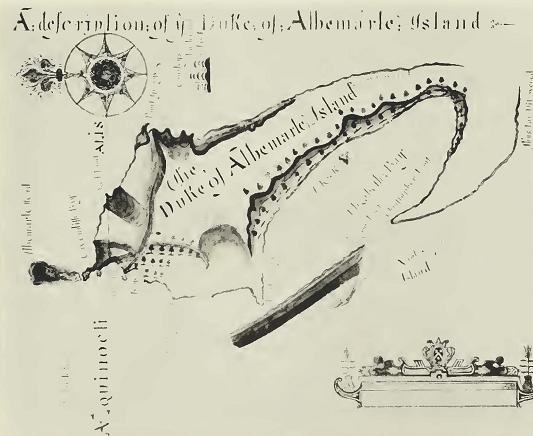

Fig. 7

Fig. 7. Cowley's drawing of Albemarle Island.

22 CALIFORNIA ACADEMY OF SCIENCES [Oc. Papers

winds being from the southeast. In later years, two more anchorages were plotted by the British: Sappho Cove, Chatham Island, by H.M.S. Sappho, after which the cove was named, and Webb Cove, Albemarle Island, named after G. A. C. Webb, navigating officer of H.M.S. Cormorant, which made the survey.

      The Italian, French, and United States navies also participated in mapping the Galápagos. In 1882 and 1885, the Italian corvette Vettor Pisani visited Wreck Bay, Chatham Island, and in 1887 Midshipman Estienne of the French corvette Decres plotted an anchorage at Black Beach, Charles Island. In 1909, the U.S.S. Yorktown charted Cartago Bay on the east coast of Albemarle, and as late as 1925, a reconnaissance of Darwin Bay, Tower Island, was made by the U.S.S. Marblehead. In the last general survey, made by the U.S.S. Bowditch in 1942, there was at least one major correction, the removal of the supposed well-formed crater on Indefatigable. This crater appears on all charts to that date but is now known not to exist. Since the islands were used as a military base during World War II they have been flown over and mapped from the air, and the great mountains no longer hold any secrets.
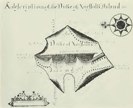

Fig. 8

Fig. 8. Cowley's drawing of Indefatigable Island which he called Duke of Norffolk's Island.

No. 25] SLEVIN: THE GALAPAGOS ISLANDS 23

      In May, 1932, Captain Garland Rotch of the yacht Zaca, while on the Templeton Crocker Expedition of the California Academy of Sciences to the Galápagos Islands, made two sketch surveys of anchorages not yet charted. One of these was on the northeast side of Narborough Island and he called it California Cove. The other was Academy Bay, Indefatigable Island, locally known as Puerto President Ayora, although Academy Bay is its official name.

      In 1892, the Republic of Ecuador renamed the Galápagos "Archipielago de Colon," in honor of the famed mariner Christopher Columbus, and that is the official name. Galápagos, however, seems to be preferred, and is more commonly used.

      The survey made by Captain Alonzo de Torres, of the Spanish Navy, in 1793, under the orders of the Viceroy of Peru, was useless as a navigational chart, but added some new names to individual islands, though it is not possible to attach them to the correct ones in most cases.

      From a study of Cowley's map, the islands can be properly placed. The large bight on the west coast of Duke of Norfolk Island (Indefatigable) is Conway Bay and this gives a fix for Duncan Island, though the island is a little off position. Albemarle and James are decidedly so and taking this into consideration Duncan Island is the Sir Anthony Dean's3 of Cowley, and his chart reads as follows:

Duke of Albemarle Island
The Earl of Abington's Island
Captain Bindlos's Island
Brattles Island
King Charles's Island
Grossman's Island
Lord Culpeper's Island
Dassigney's Island (Chatham)
Dean's Island (Duncan)
Ewres's Island (Tower)
King James's Island
Narbrough Island
Duke of Norfolk's Island (Indefatigable)
Lord Wenman's Island
Albanie Island
Cowley's Inchanted Island

      Considerable confusion has resulted from applying so many different names to the islands. The following list of the more important


      3 A famous shipwright in the reign of King Charles II.


24 CALIFORNIA ACADEMY OF SCIENCES [Oc. Papers

Fig. 9

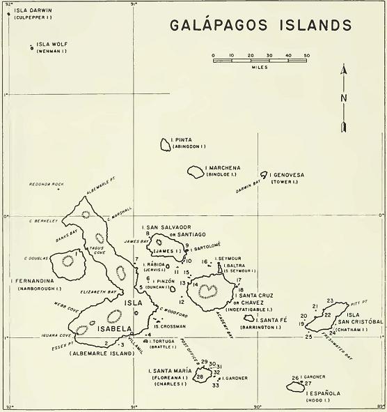
Fig. 9. Map of the Galápagos Islands with the principal islands and localities named. Minor islands, rocks, and other localities are indicated by number as follows: 1. California Cove, 2. Cape Rose, 3. Union Rock, 4. Bura Rock, 5. Cartago Bay, 6. Blanca Rock, 7. Cowley Island, 8. Albany Island. 9. Sulivan Bay, 10. Bainbridge Rocks, 11. Beagle Islands, 12. Nameless Island. 13. Eden Island, 14. Conway Bay, 15. Guy Fawkes Islands, 16. Daphne Islands, 17. Gordon Rocks, 18. Plaza Islands, 19; Wreck Bay, 20. Dalrymple Rock, 21. Kicker Rock, 22. Sappho Cove, 23. Terrapin Road, 24. Este Rock, 25. Whale Rock, 26 Lobos Rock, 27. Gardner Bay, 28. Black Beach, 29. Onslow Islands, 30. Champion Island. 31. Enderby Island, 32. Caldwell Island, 33. Watson Island.

No. 25] SLEVIN: THE GALAPAGOS ISLANDS 25

names will help to identify synonyms. [The present official names are printed in boldface type. — Editor.]


English Named after Other names
Abingdon Earl of Abingdon Pinta, Geraldino
Albany
Albemarle George Monk, Duke of Isabela, Santa Gertrudis
    Albemarle
South Seymour Baltra
Barrington Admiral Samuel Santa Fe
    Barrington, R.N.
Beagle
Bindloe Captain John Bindloe Marchena, Torres
Brattle Nicholas Brattle Tortuga
Bartholomew Lt. David Ewen Bartolome
    Bartholomew, R.N.
Caldwell Admiral Caldwell, R.N.
Champion Andrew Champion,
    whaler
Charles King Charles II Santa Maria, Floreana
Chatham William Pitt, First Earl San Christobal, Dassig-
    of Chatham     ney, Grande
Cowley Ambrose Cowley,
    buccaneer
Crossman Richard Crossman Los Hermanos
Culpepper Lord Culpepper Darwin, Guerra
Daphne H.M.S. Daphne
Duncan Admiral Viscount Dun- Pinzon, Dean
    can, R.N,
Eden
Enderby Samuel Enderby, whaler
Gardner Lord Gardner
(near Charles)
Gardner
(near Hood)
Guy Fawkes The English conspirator
Hood Admiral Viscount Sam- Espanola
    uel Hood, N.R.
Indefatigable H.M.S. Indefatigable Santa Cruz, Bolivia,
    Norfolk, Porter, Val-
    dez, Chavez, San
    Clemente

26 CALIFORNIA ACADEMY OF SCIENCES [Oc. Papers

English Named after Other names
James King James II San Salvador, Olmedo,
    Santiago, Gil, York
Jervis Admiral John Jervis Rabida
Nameless Isla sin Nombre, Bewel
    Rock
Narborough Admiral Sir John Nar- Fernandina, Plata
    brough
Onslow
Plaza
North Seymour Seymour
Tower Genovesa, Ewres
Watson
Wenman Lord Wainman Wolf, Nunez, Gasna,
    Genovesa Ewres

      In addition to the above islands, there are a number of islets which are referred to as rocks. The principal ones are as follows: Bainbridge, Blanca, Bura, Dalrymple, Este, Gordon, Kicker, Lobos, Redonda, Union, Whale. The two outstanding rocks are Kicker Rock, off the northern coast of Chatham, which has been referred to as "Sleeping Lion," and spoken of many times by Captain Colnett as the "remarkable rock," and Roca Redonda, about fifteen miles off the north point of Albemarle. This rock was no doubt named on account of its shape, redonda meaning square sail. Both of these rocks are pictured on the chart of Captain Pipon. Both Captain Colnett on the Rattler and Captain Porter on the Essex had difficulty with the currents setting them too close to Redonda and narrowly escaped hitting it.

      Many of the capes and bays of the Galápagos were named after the ships which surveyed them or after people connected with the history of the islands, such as:


Albemarle Island:

Banks Bay, after Sir Joseph Banks, famous botanist.
Essex Point, named by Porter after Frigate Essex.
Tagus Cove, H.M.S. Tagus, called Banks Cove by Colnett.
Cape Berkeley, The Honorable Ca])tain Berkeley, R.N.
Cape Rose, Jean Rose, buccaneer and companion of Davis (Davies)
Webb Cove, Lieutenant G. A. C. Webb, R. N.

No. 25] SLEVIN: THE GALAPAGOS ISLANDS 27

James Island:

Cowan Bay (James Bay) named by Captain Porter in memory of
    Lieutenant John S. Cowan of the Frigate Essex, who was killed in
    a duel and buried there.
Sulivan Bay. Lieutenant James Sulivan of H.M.S. Beagle.

Chatham Island:

Sappho Cove, H.M.S. Sappho.

Indefatigable Island:

Academy Bay, American schooner Academy.
Conway Bay, H.M.S. Conway.

EARLY VISITORS

      To list all the vessels which have visited the Galápagos would be rather an impossible, as well as a useless task, many of them being mere pleasure yachts with no serious purpose in view. The vessels of the early visitors, men-of-war, and those engaged in expeditions, however, have a direct connection with the islands, being a real part of their history, and it is to these that attention is given.

      Before the opening of the Panama Canal, ships of the Royal Navy going to, or coming from, station at Esquimault, invariably made the Galápagos a port of call to look for shipwrecked sailors or chart some particular anchorage. Men-of-war of several nations, including the United States, Great Britain, France, and Italy, have made regular surveys, or at least a reconnaissance of certain parts of the island coastlines.

      After their discovery, the Galápagos were deserted for some ten years or more, their next visitor being Diego Rivadeneira who landed there in 1546. A former captain of Diego Centano who had broken relations with Pizarro and was now waging war against him, he was sent to the coast to procure a vessel in which he and his companions might escape the civil war then being waged by the Spaniards. On arriving at Arica, he, by deceit and treachery, seized a ship, deserted his commander, Centano, and put to sea so as not to fall into the hands of the conqueror, Pizarro. Like Fray Tomas, he also encountered baffling winds and currents and was carried out to the Galápagos, where, like other visitors, he arrived short of food and water. He was immediately struck by the size of the giant tortoises, the iguanas, and the tameness of the birds, which he commented on when he finally arrived in New Spain.

28 CALIFORNIA ACADEMY OF SCIENCES [Oc. Papers

      Incidentally, he is the first to make mention of the Galápagos hawk, a striking and familiar bird on many of the islands. Replenishing his supplies, he once more attempted to reach New Spain and after a difficult voyage, beset by calms and currents, landed in what is now Guatemala. Strange to say, he, like the discoverer, gave no name to the land he had visited.

      When in 1573, Basco Nunnez de Balboa marched across the Isthmus of Darien, he climbed the mountains forming the backbone of the isthmus and was the first European to see the waters of the Pacific Ocean. From his position, on the top of the mountain ridge, the waters of both the Atlantic and Pacific were visible. The isthmus extending in an easterly and westerly direction, he had the Atlantic at his back to the north and the Pacific to the south, which he called the South Sea and by which name it was thereafter known to the early navigators. In these waters, bordering Central America and northern South America, the buccaneers spent much of their time looting and burning the coastal cities and towns and capturing the Spanish ships they encountered. It was the Galápagos they used as a base to victual, fuel, water, and careen their ships while cruising these waters in search of their quarry. Among the most famous were Davis, Cook, Wafer, Knight, Dampier, Ambrose Cowley, and John Eaton.

      On April 8, 1684, Captains Eaton and Cook in the Nicholas and Bachelor's Delight sailing from Juan Fernandez to the American coast, sighted one of the eastern islands of the Galápagos on May 31, 1684. On board these ships were Dampier, Cowley, and Davis. Proceeding to James Island, anchorage was made on the west coast, to the southward of Albany Island. Cowley named this anchorage Albany Bay and it was thereafter one of the favorite spots of the buccaneers, as it was here they found an abundance of tortoises, fire wood, and, in the rainy season, a sufficient supply of water for their ships.

      Some one hundred years after. Captain James Colnett in the ship Rattler visited this very spot and mentioned that some of his crew found old stone jars, daggers, and implements of iron scattered about. Here, the buccaneers erected shelters and made caches of provisions to replenish Iheir stores on future visits, and it was here that Dampier remarked that the tortoises were very fat and that the oil saved was stored in jars and used instead of butter to eat with dumplings.

      On this visit, the presence of snakes in the Galápagos was first mentioned, when Dampier said "There are some green snakes on these islands."

      Among the precious documents preserved in London are the diaries of two of these buccaneers, Cowley and Davis, and as they deal so inti-

No. 25] SLEVIN: THE GALAPAGOS ISLANDS 29

mately with the early Galápagos history, specimen pages of them are reproduced, with the permission of the British Museum, given from photostatic copies of the originals. To portray a true picture of the life of a buccaneer in the Galápagos over 200 years ago, transcriptions of several pages of each diary are given below.4


Excerpts from the Journal of Ambrose Cowley

May 1684

      Our departure from the Lobos to the Iland Gallapagoes with the description of those Ilands and what wee did there

—————

      The 19th day of May about 5 in the afternoone wee departed from the Lobos bound for the Gallapagoes which by the account wee had of them were Ilands lyeing under the line about 90 or 100 leagues off shoare

      Wee tooke all the prises with us and steered away N W by N till within half a degrees from the Equinoctiall and had the winds at S S W and S by W at last at So: a small gale and then our prises could hardly maintaine their Latitute

      The 31: day of may about noone wee first discovered the Ilands and at 5 a clocke anchored at the Easter side of the Eastermost Iland in 16 fathom water hard sand a mile from the shoare Cap.n Eaton came to a mile to Leward of us and one of the Prises gott to anchor at the north End of the Iland but the other two could not fetch in

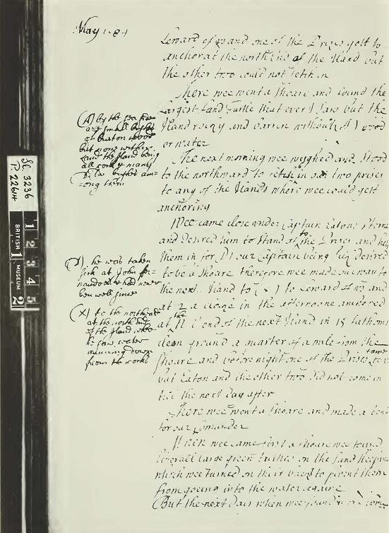
      There wee went a shoare and found the Largest Land Turtle that ever I saw but the Iland rocky and barren without (A) wood or water

      The next morning wee weighed and stood to the northward to fetch in our two prises to any of the Ilands where wee could get anchoring.

      Wee came close under Captain Eatons sterne and desired him to stand of to the Prises and help them in, for (D) our Captain being sick desired to be a shoare therefore wee made our way to the next Iland to (X) to Leward of us and at 2 a clocke in the afternoone anchored at the N E end of the next Iland in 15 fathoms clean ground a quarter of a mile from the shoare and before night one of the Prises

—————

      (A) by the sea sides are small bushes of burton wood but none within land the Iland being all rock and many Dita bushes among them

      (D) he was taken sick at John Fernandoes and had never been well since

      (X) to the northward at the north end of the Iland where he saw water running down from the rocks


      *

4 [Because of his untimely death, the author left only tentative transcriptions of those portions of these diaries which he wished to quote. These transcriptions have been re-worked and completed with the assistance of a number of people, especially Mr. Alan E. Leviton, Dr. Leo G. Hertlein, Mr. Ignatius McGuire, and Dr. John B. Gleason. The first three are staff members of the California Academy of Sciences and were very helpful in deciphering certain particularly difficult passages. Dr. Gleason is a member of ihe Department of English, University of San Francisco. He carefully went over the transcriptions, checked them against the photostatic copies, and contributed a number of important final corrections and completions. Owing to the lack of photostatic copies among the author's effects, it has been impossible to check any others of his numerous transcriptions against the original manuscripts. — Editor.]

30 CALIFORNIA ACADEMY OF SCIENCES [Oc. Papers

came to us but Eaton and the other two did not come in till the next day after

      There wee went ashoare and made a tent for our Commander

      When we came first ashoare wee found severall large green turtles on the land sleeping which wee turned on their backs to prevent them


Fig. 10

Fig. 10. The first of three pages from the diary of Ambrose Cowley. See the accompanying transcription of this page and those shown in figures 11 and 12.

No. 25] SLEVIN: THE GALAPAGOS ISLANDS 31

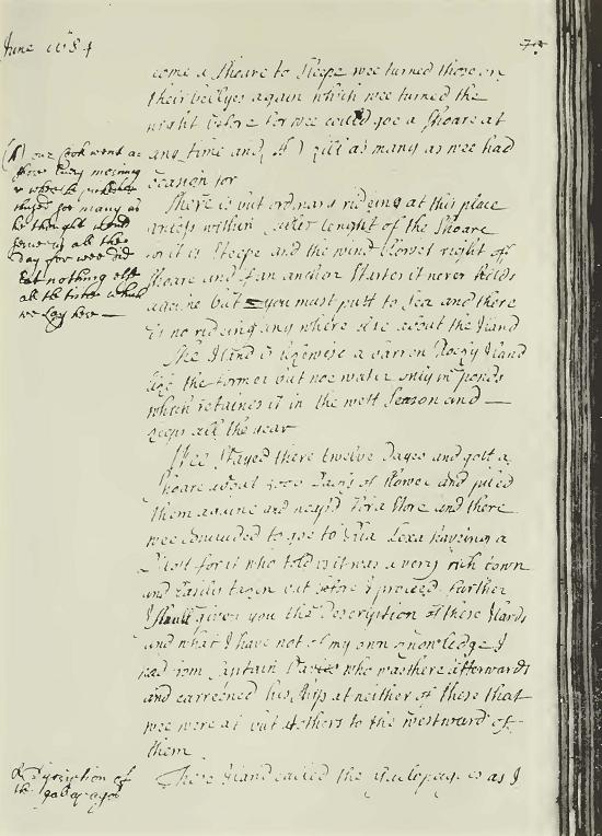
from goeing into the water againe. But the next day when wee found more come a shoare to sleepe wee turned those on their bellyes again which wee turned the night before for wee could go ashoare at any time and (A[l] ) kill as many as wee had ocasion for


Fig. 11

Fig. 11. The second of three pages from the diary of Ambrose Cowley.

—————

      (A [1]) our cook went ashore every morning & where he picked & chused soe many as he thought would serve us all the day for wee did eat nothing else all the time which we lay here

32 CALIFORNIA ACADEMY OF SCIENCES [Oc. Papers

      There is but ordinary rideing at this place unless within Cables lenght of the shoare for it is steepe and the wind blows right off shoare and if an anchor startes it never holds againe but you must putt to sea and there is no rideing any where else about the Iland.

      The Iland is likewise a barren Rocky Iland like the former but noe water only in ponds which retaines it in the wett season and keeps all the year

      Wee stayed there twelve dayes and gott a shoare about 5000 sacks of flower and piled them againe and heap'd for a store and there we concluded to goe to Ria Lexa haveing a Pilott for it who told us it was a very rich town and easily taken but before I proceed further I shall give you the description of these Ilands and what I have not of my own knowledge I had from Captain Davies who was there afterwards and careened his ship at neither of these that wee were at but at others to the westward of them

      These Iland called the Gallopagoes as I [I]

June l684

      have been told doe reach from the latitude of one Degree south to 5 degrees north tending N W but of that wee have noe certainty therefore I shall only speake of these which I have seene which lay all of them under or neare the Lyne within a degree of either side

      These are about 14 in number most of them large considerable Ilands they all of them swarme with Land Turtle and guanos which are both extraordinary fatt and sweete and the sea abounds with green turtle and fish

      I have allready given some relation of the green (A[2]) Turtle which are soe plenty there that though wee were about 200 soules yett wee killed every morning on the Bay as many as served us all day the whole time of our abode there and might have kill'd many more though they differr in nature from the West India Turtle yett are very sweet wholesome meate

      And the (b) fish is as plenty there as at John Fernandoes

      Guanos are as plenty there as in any place of the world and extraordinary sweet meate but the Land Turtle as they exceed in sweetness soe doe they in like manner in numbers for it is incredible to reporte how numerous they are and I beleive there is not any place in the world that have such plenty of these Creatures — Now left us consider if there is any thing else worth of observation in these Ilands

      In the first place I have denoted those two which I was on, to be

—————

      (I) Description of the gallapagos

      (A [2]) the turtle is a large Creature living in the sea but comes ashore to lay eggs wch are hatched by the sand there are three sortes of them, the green turtle the hawkes bill and the log or head, the first are good wholesome meat but their shells very thin and used for inlay and not worth above 4 d ye pound the hawkes bill are indifferent good meat in some places but much ranker than the green turtle but each shell of great vallew but the Logerhead soe called from ye bigness of his head is neither good flesh nor shell yet sometimes Eaton but they are all better or worse meat according to the ground they feed in

      (b) see page (66)

No. 25] SLEVIN: THE GALAPAGOS ISLANDS 33

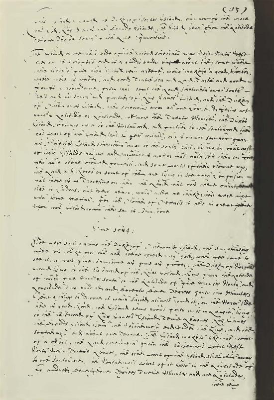
barren dry Ilands. I must confess my Curiosity would have carryed me further in search to find any thing profital on them but our business was not to search places to settle in, only to finde conveniencies
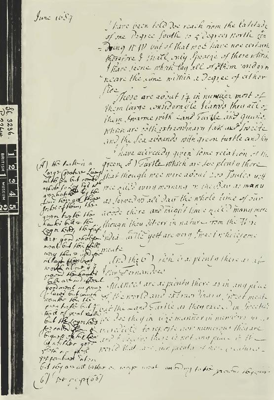

Fig. 12

Fig. 12. The third of three pages from the diary of Ambrose Cowley.

34 CALIFORNIA ACADEMY OF SCIENCES [Oc. Papers

to Carreen which at this time wee did not think convenient yett Captain (A[3]) Davies after I left him came thither and carreened at some Ilands to the westward of these wch he found to be good habitable Ilands haveing a deep soft soyle which if cultivated would produce any thing that grows in these Clymatts

      They likewise are well watered and plenty of good timber fitt for any uses and places enough to carreen in, soe that take them by and large they are extraordinary good Ilands where a ship in distress may have any thing that can be expected from places not inhabitated for there is both food and water and fire wood and timber for other uses besides masts and yards may be had and good secure places to Carreen in and with a little payne salt may be gathered

      Wee departed from the Gallapagoes bound to the Iland Cocos which wee mist ....

      this Iland where wee Lay is in 00° 30 m no Latt.


Excerpts from the Journal of Edward Davies5

      Wee lay at Lobus above eight and forty houres, and knowing that wee had more than an hundred prisoners on board not knowing where to gett water, nor where to find a place of making a Magazeene for flower but that wee should be hunted out and have our flower destroyed, wee sailed away to the Westward to see if wee could find those Islands called the Galipoloes, which made the Spaniards laugh at us telling us they were Inchanted Islands, and that there was never any but one Captaine Porialto that had ever seene them, but would not come neare them to Anchor at them, and that they were but shadowes and noe reall Islands. Wee steered away North West till wee came under the Line, then wee Directed our Course West and West by South, wee having the wind at South South East.


June 1684

      About the beginning of this Month wee saw an Island on our Starboard side making high Land and Low Land, being a very likely Island to have water, upon being well Repleinshed with wood, but by reason of the strong Current that runneth there wee could not fetch it, That Island I named King Charles the Seconds Island, by my Judgement it lyeth in the Latitude of one South Latitude and Thirty Minutes — Longitude two hundred and seaventy eight Degrees and fifty minutes standing still to the Westward I saw severall Islands, but that which I liked best, I came to Anchor under in a good Bay having seaven fathom water, there being upon this Island to the South end a good Harbor for many Shipps to ride, I beleive his Majestyes Navy might ride there in safety, wee put the Boat a shoare, but found no water there but wee found Land Turtle very great, and Sea turtle very


      5 Ambrose Cowley is followed in the spelling of Davies though it is commonly found Davis in the literature.

      (A [3]) when he was here the second time Eat nothing but Land turtle and gave 6 or 7 Jars of oyle for each mess

No. 25] SLEVIN: THE GALAPAGOS ISLANDS 35

good and large and great plenty, and a sort of ffowles called fflemingo with Goanoes, which our men brought aboard, the small Birds being not in the least possessed with feare, they lighted on our mens heads


Fig 13.

Fig. 13. A page from the diary of Edward Davies. See the accompanying transcription.

36 CALIFORNIA ACADEMY OF SCIENCES [Oc. Papers

and Armes and they tooke them off, which at first seemed strange to me but I did the same my selfe after that.

      This Island I named the Duke of Yorkes Island, but now by the Grace of God King James the Seconds Island. The Island lyeth from the Latitude of one Degree South to the Line Equinoctiall:

      The Island on the East side of the Island stretches away West North West and at the Westmost end is a goodly sandy bay about the point where there lyeth a fine high Island very greene, which maketh a good Harbor, where there is water, and good Turtle Sea and Land Turtle and good ffowles in abundance, from that point the Land stretcheth away South West and by South and further of King James's Island, and the Duke of Albemarles Island, they stretching away all one Course, differing not much in Latitude or Longitude, not more than twenty Minutes, the Dukes Island stretching more to the Northward, and further to the Southward then that part of the Island that I . . . withall, but I cannot say how farr his Ma jestyes Island stretcheth away to the South East, by reason that most of those Islands having had sulphurous matter that hath sett them on fire, they have beene burned formerly, and some parts of them blowne up, the Land and Rocks or some of them are lying in soe much Confusion that there is no Travelling on them, the Land that has beene burnt seemed like to Cindars, but very heavy, which made me thinke they were mixt with some mettall, for the Mother of Mettalls is here in great plenty upon this Iland which they say is Brimstone


June 1684:

      Wee were sailing along the Duke of Albemarles Island, the sun shineing made us thinke our hill had been coverd with Gold, when wee came to see it, it was fine Brimestone as fine as flower. The Duke of Norfolks Island lying to the Eastward of the Kings Island, lying from the Latitude of thirty five minutes South to the Latitude of five minutes North, and Longitude two hundred and seaventy seaven Degrees forty two Minutes; I sent a shipp to discover it which sailed allmost round it, on the North side there is good Road, the Island being about forty miles in Length, lying to the Eastward of King James's Island tenne Leagues: King James the Seconds Island lyeth the Northermost end under the Line, and the Southermost end about one Degree. The Island maketh like the point of a ffort, the Land stretcheth from the Eastermost point West North West twelve Leages, the other part of the Island stretcheth away to the Southward, the Northermost part of it lyeth in the Longitude of Two hundred seaventy seaven Degrees twelve Minutes and noe Latitudes, There being upon this Island Land turtle allmost two hundred pounde weight a peice, I sate upon the Back of one of them when they came aboard to try his strength, he would have carryed me had I beene much heavier, the flesh of them to many of our Judgements exceeded the sea turtle, although the sea turtle there is as good as ever I eat in any part of the World, where they have beene accounted most rare, ffrom King James's Island wee sailed to another Island lying to the Westward of the Kings Island stretching away to the Northward North West and bv West to the Lati-

No. 25] SLEVIN: THE GALAPAGOS ISLANDS 37

tude of fifteene Minutes North the Land being very high up in the Country by the water side making as you come in from the Eastward like to a long Ridge or plaine hill the Eastmost side of it being an Iron Shoare where there is no coming to an Anchor. It Looketh into the Southward of King Jame's Island, I sailed to the North end thereof where by thence I lett goe an Anchor in good ground, wee being then five shipps in Company, three of them allmost Loaden with provision, as flower, sweete Meates, and Sugar, wee seeking a place to putt this provisions on shoare against a time of scarcity, this end being the worst part of the Island, yett it affordeth provision in abundance as ffish, turtle, Alguanas, and ffowles in abundance, this Island I gave the name of the Duke of Albemarles Island there belonging to it a stately Harbour lying on the West side thereof, wee sailed along the West side of the Island towards the Southward; this Island lyeth from the Latitude of one Degree thirty Minutes South to the Latitude of ffifteene Minutes North by Judgement for wee could not gett to the South end thereof for the strong Current, but having seene it at a Distance, there being in number fifteene Islands that I have seene, I have named eight of them. . . .


June 1684

      Wee sailed to the North West end of the Duke of Albemarles Island where wee put on shoare fifteene hundred Baggs of fflower, wee carrying our Captaine on shoare he having beene three weekes sick, wee sought for water but could find none, wee were forced to go to the Mayne to water ....


      Raveneau de Lussan, a contemporary of Cowley and Davis, made some interesting remarks of his voyage to the South Seas in 1684. His journal states:

      At noon on the eighth we crossed the equator, passing the Galapes islands which lay west a dozen leagues off to the leeward.

      These eight islands stretch north and south of Cape Blanco and east and west of Queaquille. They abound in sea-tortoises that land there all day long, while in the woods it is difficult to step without finding land-tortoises and hordes of lizards and agoutis lying about. These adjacent waters are also full of fishes, that come up to die on land. On the other hand, these advantages are overweighed by the shortage of water from which these islands suffer.

      The following year (1685) Davis, accompanied by William Knight, a fellow buccaneer, made a second visit to the Galápagos. On arrival he took on some of the stores from the cache made on his previous visit and sailed for the coast of South America.

      Davis apparently appreciated the islands as he again returned in 1687 for his third visit to victual and careen his ship. After drying some fish, salting the flesh of the land tortoise, and filling sixty eight-gallon jars with the oil of the land tortoise while he was repairing his ship, he again set sail for the South American coast.

38 CALIFORNIA ACADEMY OF SCIENCES [Oc. Papers

      A later buccaneer was Captain Woodes Rogers, an Englishman, who, in 1708, with a commission from the Lord High Admiral, set out for the South Seas in the ship Duke accompanied by Captain Stephen Courtney in the Duchess. Kogers was financed by some merchants of Bristol with instructions to war against the Spaniards and the French. On May 8, 1709, Rogers left the coast of Peru bound for the Galápagos, which he sighted on May 16. The failure to water his ships before leaving the mainland prevented any lengthy stop and he left for the mainland to do so. September 10 found him back at the Galápagos where he took on a supply of tortoises and wood and left again to loot and burn the towns of New Spain and capture any Spanish ship he might encounter.

      Though the buccaneers had not entirely ceased operations, another type of seaman appeared in Galápagos waters for the purpose of exploration and annexing new lands.

      One of the earliest of this type was M. de Beauchesne Gouin, a captain in the French navy, sent out by a company formed in France for the purpose of establishing colonies in the countries of South America not yet occupied by Europeans, and also for trading his cargo with Spaniards, although they were forbidden to trade with any but their own countrymen. He sailed from France on December 17, 1698, on board the frigate Philippeaux accompanied by the bark Maurepas. After a four-months visit to the ports of Chile and Peru, Beauchesne sailed for the Galápagos, arriving there on June 7, 1700.

      Ensign Le Sieur de Villefort, of the Philippeaux, reported that neither fresh water nor trees were found, but an abundance of fish and tortoises were found to refresh the crews. From his description of the anchorage, his mention of a small island and the finding of the materials for the repair of ships, the Fhilippeaux must certainly have been anchored in what the buccaneer Cowley called Albany Bay, James Island, the isle referred to as Isle a Tabac by Villefort. According to his diary, the other two islands visited. Health Island or Isle de Saute, and the Isle Mascarin, are no doubt Charles and Hood in the order mentioned. At the latter island, he remarked with surprise the sighting of a number of large whales so near the line. After a stop of just a month, he headed south for the passage round the Horn and his return to Europe.

      In 1720 Captain Clipperton, Dampier's chief mate and discoverer of the island named after him, touched at the Galápagos to replenish his supplies for his voyage to the Bay of Panama, but makes no special mention of his activities. He cruised the South Sea, captured

No. 25] SLEVIN: THE GALAPAGOS ISLANDS 39

two or three prizes, plundered the town of Truxillo, and finally left for China.

      The voyage of Captain James Colnett, R.N., was no doubt the most outstanding of the early voyages. In 1792, Captain Colnett w^as commissioned by His Majesty's Government to investigate the possibilities of spermaceti-whale fisheries in the South Sea and his appointment was received with great pleasure by Samuel Enderby & Sons, leaders in the whaling industry of Great Britain. The matter of a proper vessel for the voyage was a problem as there was none for sale on the market. The Admiralty was petitioned for the loan of a vessel and His Majesty's sloop-of-war, Rattler, of three hundred and seventy-four tons was selected. The alterations necessary for such a voyage would make it impossible to turn the vessel back to the Navy for further use as a vessel of war, so the firm of Enderby & Sons agreed to purchase it on release by His Majesty's Government. This having been agreed upon, H.M.S. Rattler was stricken from the register and Enderby & Sons stood the expense of the alterations. Captain Colnett was granted a leave of absence to make the voyage and the Rattler became an ordinary whaler. The voyage of this vessel is so intimately connected with the islands that its log which follows will be of deepest interest to any student of Galápagos history.

      Before the extended visit which began on March 13, 1794, Captain Colnett made a short stop from June 13 to 28, 1793, when, on account of unfavorable wdnds, he sailed for the mainland. However, on June 25, he hove to long enough to send a boat ashore to look for water, which, on finding none, brought back a tortoise and several turtles.

      On June 27, he sent two boats ashore to look for water, both of which met with no success. the Rattler then was headed toward the Coast and did not return to the Galápagos until March 12, 1794, when Colnett starts the log of his second visit. The account of the June, 1793, visit is as follows:

      June 24, 1793

      We saw one of the Galápagos Islands distant about 6 or 7 leagues wore and stood off till dayliglit.

      Wore and stood to the westward Ex of land from W 10 S to W 30 N and the body which formed two points and overlaped as if two different isles W ex from S E to W 3.5 S nearest land S 7 W 8 miles. Sent a boat on shore Lat. 00° 40' 0" S Long 89° 00 W.


      June 25, 1793

      Light breezes and cloudy hove too and sent a boat on shore with the chief mate. Boat returned and found no water but saw a number

40 CALIFORNIA ACADEMY OF SCIENCES [Oc. Papers

of land birds, a few seals a tortoise a land turpan which they caught, also several turtle, a turtle dove and a guana nor was there a single vegetable that could be eat.

      Light airs and flying showers. Found the current had set us considerably to Leeward — made all sail. Lat 00° 38' 00" S Long. 89° W.


      June 26, 1793

      Mod. breezes and cloudy stood in for the land keeping the lead going sounded 36 fthms at 5 or 6 miles distant to 19 fthms at l 1/2 distant at 4 o'clock came too in 19 fthm EX of land from S 13 W to E 34 N a rock at the SW point like a sperm whales head mouth open and up. I sounded all around the ship and towards the shore the soundings gradually decreased and sandy bottom, landed with two boats ahead the ship to look for water and sent a third to the S W neither found any water but the boat that went to the Wt found much sand which we supposed from the weight contained some mineral ore.

      Lat. 00° 45' - 30" S Long 89° 26'


      June 27, 1793

      Afternoon and night moderate breezes and cloudy at daylight sent two boats away one east the other to west to search the isle for water and in the evening they retd neither of them succeeding. Through the day moderate breezes and pleasant weather. Procured many small ducks or teal and other sea birds found in these climates also great quantity of turtle of the latter more to be found on every beach than a dozen ships could destroy the boat from the west brought in a large quantity of the sand found yesterday and the crew had traveled a long way inland. I also sent one party to travel to the Eward in Land.

      Lat 45' 30"


      June 28, 1793

      During the night strong breezes and clear towards day light cloudy found nothing was to be procured here that could be expected from so large an isle in this climate at day light weighed and stood along shore to the Et ward with intentions once more to endeaver to beat round to the S.

      Lat 00° 38' S


      June 29, 1793

      Moderate breeze and Flying clouds. Many seal and birds accompanying us and great quantity of the cream colored spawn on the water as we fell in with coming from the main

      Lat 00° 47' 00" Long 88° 5'


      June 30, 1793

      Gentle breezes and hazy land N 5° W Distnt 7 or 8 Leagues Lat 1° 1" S Long 89° W

No. 25] SLEVIN: THE GALAPAGOS ISLANDS 41

      July 1, 1793

      Light airs cloudy with smooth W at 2 and pleasant sea. A small island to the south bore from W to SW distant from the nearest part 4 or 5 leagues.

      Lat 1° 19' Long 89° 39' W


      July 2, 1793

      Light breezes cloudy Made sail light breezes and cloudy the isle first anchored at to Dist 10 or 13 leagues. Saw a large school of porpoises. Mod breezes & cloudy many Birds accomp.

      Lat 1" 25' Long 88° 33' 30"


      July 3, 1793.

      Light airs and Cloudy Saw many Black fish Porpoises & Albecores — also turtles and sea birds. Slight winds inclining to calm and cloudy

      Made all sail

      Moderate breezes few sea birds seen and no fish

      Lat 1° 31' S Long 88° 00' W


      July 4, 1793

      Moderate breezes & cloudy All sails set Saw many porpoises Black fish albecores & turtle also many sea birds. Shortened sail to the topsails for the night.

      Black fish porpoises and turtles seen many birds accompany Saw a Hump back whale

      Lat 1° 24' S Long 87° 16'


      July 5, 1793

      Light breezes and cloudy weather

      Many boobies and other birds also porpoises and Black fish

      Shortened sail for the night

      Dark cloudy gloomy weather with appearance of a strong current from many riplines seen all around.

      Turtle Bonnetta Albecore Black fish and porpoises seen also Man of War birds gulls etc.

      Lat 1° 14' S Long 86° 00


      The Rattler then left for the coast of Peru and did not return until March 12, 1794, when the second visit began.


      March 12, 1794

      Saw one of the Galápagos bearing south hauled up for it.


      On March 13, 1794, the log is headed "At the Galápagos Isls."


      March 13, 1794

      Moderate bj-eezes at N. E. stood along to the SW with an intention of passing to the W of a Remarkable Rock resembling in height and size and shape on several points of view one of the Kickers

42 CALIFORNIA ACADEMY OF SCIENCES [Oc. Papers

which lay N of a Deep Bay in which one of the boats had good soundings when here before off the Rock to the N of it 2 cables length 19 fm Rocky as we rounded to the West and South no sounding with 15 fm line and the wind hauling more to the E prevented now we are getting into the East Corner.

      We at last got sounding within a mile of the shore in the W Corner a low point at 29 fm Rocky hauled out to beat up I set out with a boat to Sound the bay found good bottom at the E point 5 or 6 miles from the shore 21 fm sand two points of the Bay NE & SW the Kicker Rock W N W 2 1/2 miles got on board & tacked into the bay with the ship and came too on the same Bearings — at Day light sent two boats away one to the NE other SW to search the lee side of the isle for Salt. The Jolly Boat also went a fishing under the big Rock and in a short time caught great numbers of large Cod which from 10 to 30 weight and also sea BREAM

      Lat 00° 54' S Long 89° 36' W


      March 14, 1794

      Fresh breezes at N W by W & very strong tide ship would not lay at single anchor steadied her with a Kedge at sunset land taken for an isle bore Wst 10 S to W 10 N & another isle N 45 W thro the afternoon many Devil fish seen and sevl seals at 8 PM Boat with the whaling master retd from the SW port of the Isle but could find no salt or fresh water in a small bay at the West End found a whale plank of a large ship neither worm eaten or decayed — only the iron — he also got thirty sealskins & as many green turtle as he pleased with some few seal and saw great quantity of mullett & also a Devil fish the Jolly Boat was also sent this afternoon to the Rock to fish but having no hooks but what were made without a forge or with the Cabin Bellows in a half tubb out of iron hoops nails & sail needles — the sharks at the Isle Socoro having taken all the others away had very poor success — but one singular circumstance was a seal took hook and they afterwards got it out thro the night light winds North & Wtly supposed the kedge had come home and fouled the Bower, sighted it & came too again & steadied as before at Day light the whaling master set out to over haul the Bay we lay in for salt &c

      Lat 0° 52' 40" S Long. 89° 36' W


      March 15, 1794

      Winds thro the afternoon as yesterday whaling master retd without any salt & only one seal in the eveng landed behind a small isle in the head of the Bay which form a small cove sheltered from all winds with sevl sandy beaches on which a ship may lay on shore an Excellent place also to fix a tent a great quantitys of mullett & green turtle to be caught but unfortunately we had no seiene to catch the fish if wanted but I believe no one would eat them that could get turtle. The whaling master caught a seal & 17 young

      Through the night wind N & W

      The second mate who had been long ailing and in addition to other complaints a bad head which he had received by hurt the latter

No. 25] SLEVIN: THE GALAPAGOS ISLANDS 43

end of the year growing worse with three others who had boils the worst of them went on shore for the day.

      Lat 0° 22' 28" Long 89° 36' W


      March 16, 1794

      Winds as before weather changeable with flying showers the Chief Mate returned from the S E part of the isle without finding any salt saw a few seals and caught a few land and green turtle and saw two very small runs of water one out of the bluff that forms the N E part of the Bay we lay in and the other out of a bluff at the East end of the isle neither of these places had any run when we were here before and I conjecture its a Basin on the top as on the N. W. Coast of America which contains water all the year

      Night and forenoon cloudy Hazy light winds and calms alternately

      Lat [No position marked for this date]


      First part of the afternoon variable latter part wind from Wst to N W X W Cloudy most of the crew on shore or liberty in the even they returned one of them caught a snake 4 ft long only the size of my little finger

      Flying showers very changeable and heavy thro the night at 4 a m began to heave our anchor up by 8 got it & kedge stowed it was at this time very cloudy over the land and also around the horizon with light airs of wind mostly west'ly that we did not by noon only get 3 miles S of the Remarkable Rock in the Bay the weather at this time began to look as gloomy and heavy as ever I saw it and the least I expected was a heavy tornado but it ended in a torrent of rain from noon till 8 at night when it ceased.


      March 17, 1794

      Ex of the Isl at anchor N E by E to SW by S the Remarkable Rock SSW & mineral mount E by N

      While beating out between Mineral mount & the big Rock our sounds was regular and good Bottom and we neared each shoaling gradually from 14 to 30 fm on the Mount side & 18 to 30 for the Rock.

      No observation


      March 18, 1794

      Light & calm alternately Var wind & torrents of rain with constant small rain and threatng Wear. Short sail occasionally Remarkable Rock SW SW by W Ex of land from E by N S b W 1/2 W Hove too Breeze and rain ceased calm & cloudy strong current setting us to the SW

      Lat 52' 22" S Long 89° 56'


      March 19, 1794

      Light airs & variable with frequent showers and heavy S'ly swell Breakers said to be see ahead and many other isles to the S & W of us

      At noon the Body of the Western most W 10° N Body of the Eastern most E 19° N Dist from the western most 11 or 12 miles away many small islands in sight

      Lat 31' 15" S Long 90° 9'

44 CALIFORNIA ACADEMY OF SCIENCES [Oc. Papers

      March 20, 1794

      Light winds and hazy with S'ly swell. Shortened sail for the night & sounded 150fm no bottom stood off and on for daylight the isle intending to land on from N 26 E to N 3 E Dist 9 or 10 mi Many seals seen

      Made sail found the current had set us so far to Leeward as scarce to discern the Isle intended to land on At noon the Isle off last night a large isle which I take for Albemarle N 15° W to N 10° W & a small flatt Isl. Gave chase to windward with boats and ship to sperm whale

      Lat 31' 51" S Long 90° 9'


      March 21, 1794

      Light winds & very hazy weather neither boats nor ship could come up with the whale. Weather with heavy S'ly swell many seals seen Found the set to the S & W so great & the wind so light very uncertain when we should get up with the isle we wished bore up for Albemarle Isl Many seals and storm petrels

      Lat 1° 19' 32" S Long 91° 6'


      March 22, 1794

      Moderate Breezes & very hazy hove too & sounded 150 fm no bottom Dist 3 or 4 miles from the shore shortened sail & ply'd to windd for the night Sounded 150 fm no bottom

      Moderate breeze & heavy S'ly swell innumerable quantity of storm petrels & a few seals seen at noon within a few miles of the shore of Albemarle Isl

      Lat 1° 19' 32" Long 91° 6'


      March 23, 1794

      Moderate breezes & cloudy. Sounded 150 fm no bottom Boat went away to sound the Bay finding no bottom within a mile of the shore & saw nothing but an Iron Bount Inhospitable barren coast the distt part of the Bay too far off to reach before dark and wind blowing right out with an overfall that a boat would scarce line, the ship had by the time the boat joined got between two eddies of wind made by the south point & cor of the Bay & it was with some difficulty we got clear out by 10 at night and hove too at noon Ex of land from N 12 E to E 37 S

      Lat 0° 35' 6" Long 91° 33'


      March 24, 1794

      Light breezes and showers at times within a few miles of Narborough Isle and doubtful of clearing the shore the current setting so strong

      Light and cloudy found the current set as along shore at noon Ex of Narl)orough Isle from S 21 E to S 52 E a high Bluff the N W point of Albemarle Isle from E 4 N to E 27 N Rock Rodondo N 5 E 5 or 6 Leag.

      Lat 0° 35' 6" 91° 33'

No. 25] SLEVIN: THE GALAPAGOS ISLANDS 45

      Sent a boat away to sound under the N W point of Albemarle Isle for anchorage


      March 25, 1794

      Light airs and hazy with showers of small rain laying too for the Boat returned and found the N W part of the isle as Inhospitable and barren as the SW no anchorage for a ship caught a number of excellent rock cod and a Hump Back turtle no other seen but on several parts of the shore a few seals

      Light airs gave chase to a sperm whale at noon Rock Rodando E 25 S got alongside the sperm whale

      Lat 0= 37' 13" Long 91° 28'


      March 26, 1794

      Light airs and hazy employed flenching saw a large body of sperm whale Boats gave chase & killed 3 & got them along side.

      Light airs & cloudy

      Saw sperm whale in the S at noon flenching and got on board all our blubber & made sail Rock Rodondo E 7° S Ex of land from E 14 S to S 39° E

      Lat 0° 21' 34" N Long 91° 52'


      March 27, 1794

      Light airs and variable employed cutting and boiling saw spouting fish a long Dist to windd suppd to be sperm whale at sun set saw two dead whale at a long dist. too late to go after them.

      Light airs inclining to calm saw another dead whale got it alongside & flenched it at noon land covered in haze strong current setting to the NW

      Lat 0° 18' 22" N Long 92° 06'


      March 28, 1794

      Light airs very hazy with heavy S'ly swell

      Shortened sail and hove too

      Light breeze and hazy made sale at noon Rock Rodondo N 56° E

      Lat 0° 11' 37" Long 91° 45'


      March 29, 1794

      Light & Cloudy inclining to calm

      Fresh breezes with heavy rain in showers found another dead whale but unfit for use

      shortened sail for the night finished boiling saw dead whale bursted

      Body of Narborough Isle SE by S

      Lat 0° 10' 35" N Long 91° 51'


      March 30, 1794

      Light airs and hazy weather

      Light wind & Hazy made said saw sperm whale gave chase killed one and got it along side at noon Rock Rodondo E 25° N

      Lat 0° 10' 35" N Long 91° 45'

46 CALIFORNIA ACADEMY OF SCIENCES [Oc. Papers

      March 31, 1794
     

      Light airs & hazy & S W swell
      calm
      Light airs & SW Swell
      N W point of Albemarle Isl E 4° 30' S other land covered in haze
      Lat 0° 8' 48 N Long 91° 38'


      April 1, 1794 Light and hazy with heavy SW swell
      Seals porpoises Black fish Bonetta Albecore, etc.
      Caught large Albecore Black fish porpoises &c as before & sev'l Breaches to the Eward Supposed sperm whale
      at noon Rock Rodondo E 14 S
      Body of Narborough Isle S E by S
      Lat 0° 22' 0" N Long 91° 40'


      April 2, 1794
      Light breezes & heavy SWy swell
      Porpoises & other fish and birds as yesterday
      Sent a boat to Rock Rodondo to fish gave chase to a sperm whale
      Lat 0° 24' 29" Long 91° 36'


      April 3, 1794
      Light airs and hazy weather hazy weather
      Made the boat signal at the rock to join the chase
      Boats ret'd killed 5 sperm whale but night coming on only secured 3 alongside saw one of our whales killed last night and got it along side the current having drove it near to 4 leagues from where it was killed
      Got all our blubber and heads in made sail to look for other whale
      Lat 0° 16' 38" Long 91° 54'


      April 4, 1794
      Light airs & hazy weather & S W swell Porpoises and Blackfish innumerable
      Rock Rodondo E N E Heavy dew calm & hazy Porpoises seals &c as before
      Land covered in haze Finished boiling
      Lat 0° 14' 28" Long 92° 10'


      April 5, 1794
      Light airs and pleasant weather but hazy saw whale spout and Breach whale and porpoises ennumerable seen
      no sight of land at noon no sight of land
      The ship set to the N


      April 6, 1794
      Light winds and hazy with S W swell Few fish or birds of any kind scene & no sight of land. All sail set Lightning in the N W

No. 25] SLEVIN: THE GALAPAGOS ISLANDS 47

      Set Royals and mizzen top gallant sail no sight of land ship set to the N and Wtward
      Lat 0° 55' 19" Long 90° 20'


      April 7, 1794
      Light airs very heavy S W Swell caught a turtle no sight of land caught a Bonnetta Strong set to the wewd no sight of land many porpoises saw sev'l turtle no sight of land a strong set to the N & Weward
      Lat 0° 32' 32" Long 94° 15' 80"

      April 8, 1794
      Light breezes and heavy haze
      Large Bodys of Hump Back and fin Back Whales seen also porpoises
      Inclining to calm
      Saw Albemarle Isle bear E S E 11 or 12 leagues. Saw a sail inshore
      Lat 0° 8' 34" N Long 91° 45'


      April 9, 1794
      Light and hazy Saw a sperm whale
      Ship fired a heavy gun Calm & thick weather
      Fog cleared the ship making sail after us & not liking her appearance made sail from her Lat 0° 19' 52" Long 91° 52'


      April 10, 1794
      Moderate breeze and smooth water Chase coming up with us. Cut the ships taffrail down to get our two guns out over the stern found no chance of escaping the chase hove too and prepared to make the best defensive resistance we could at 5 the chase spoke us found her to be the Butterworth of London from the N. W. to Europe & at those isles in search of water.
      Ship in calm Land covered with haze
      Lat 0°17' 0" 91° 49' 30"


      April 11, 1794 Light airs and thick fog inclining to calm & SWi swell
      Albemarle Isl S E at intervals clear Ship in company
      Lat 0° 33' N Long 91° 57' W


      April 12, 1794
      Light airs with S"iy swell at times foggy saw Culpepers Isle Light winds very hazy at noon Culpepers Isl N b W & N part of Albemarle Isle S E by S
      Ship in Co
      Lat 0° 49' 40" Long 92° 3'


      April 13, 1794 Light airs Siy swell & very hazy inclining to calm with a strong set to the Nhward

48 CALIFORNIA ACADEMY OF SCIENCES [Oc. Papers

      Culpeppers Isle N & N part of Albeme Isle S 35 E
      Lat 0" 53" Long 92° 03'


      April 15, 1794
      Calm Killers & Porpoises seen SE swell Albemarle Isle SE by E 12 or 15 leagues
      Lat - 41' 20" Long 92° 39'


      April 16, 1794
      Moderate breezes & Hazy wear with S'ly swell and strong N W current Capt. Sharp of the Butterworth having agreed to remain with us to the end of our voyage by which the good of each parties owners was reciprocally considered. When we arrived at Albanie Bay King James Isle Galápagos to refit and sail together whaling and sealing he being short of casks asked us to supply him with 20 tons of casks & he us a certain quantity of salt in exchange & in every other respect to assist each other but not in partnership
      Lat 0° 14' 34" Long 91^ 39'


      April 17, 1794
      Strong breezes & Hazy with confused sea. The slings of the main yard broke and main yard came on deck at the same time starboard fore topsail sheet gave way by which we drifted considerably to leeward our consort hull down to windward beating up for Albanie Bay King James's Isle
      Fin Back whale and porpoises seen
      Lat 0" 27' 37" Long 91° 24'


      April 18, 1794
      Light breezes and hazy all sails set
      Fin Back whale and porpoises seen Beating up for Albanie Bay King James's Isle
      Our consort hull down to leeward
      Lat 0° 19' 40" Long 91° 16' W


      April 19, 1794
      Light winds hazy wear Strong riplines of currents all sail set beating up for Albanie Bay King James's Isle Sent out boat to speak our consort Boat ret'd not being able to overtake our consort Albemarle I S by W thro the haze Our consort Hull down a Head
      Lat 0° 46' 53" Long 90° 28'


      April 20, 1794
      Light airs and hazy weather inclining to calm
      Saw our consort in the N E descernable from the
      Lost sight of our consort Light airs & very hazy part of Albemarle Isle seen
      Lat 0° 32' 26" N Long 90° W


      April 21. 1794
      Light Breezes & Hazy made all sail
      Black fish and porpoises seen Saw our consort in the West dis-

No. 25] SLEVIN: THE GALAPAGOS ISLANDS 49

cernable from the Mast head Albemarle Isle in sight In haze Abington Isle E & N to E Dist from shore 3 or 4 miles our consort cumming
      Lat 0° 38' 57" Long 89° 46"


      April 22, 1794
      Light breeze & clear Sent the Chief mate to surround the isle in search of Salt fresh water or refreshments for the crew Number of Black fish and porpoises The Butterworth joind Co & was now reduced to one Butt of water supplied them 3-30 gallon casks Saw Fin back whale
      Abington lise S 20 E Distant from nearest shore line 3 or 4 miles
      Lat 0° 50' 16" Long 90° 57' 30"


      April 23. 1794
      Light breezes Boat having surrounded the Isle & found the onlyanchorage in a Bay at the S point sandy bottom at 2 miles from the shore 7 ft™ he also brought turpin green turtle & Rock Cod but saw no salt or fresh water.
      Light breezes & vary many Black fish Bindloes Isle E 1° 30' No Abington Isle S by E
      Lat 0° 16' 36" Long 91° 4'


      April 24, 1794
      Moderate Breezes and Hazy Wet'ir. Bent the cables and got anchor over the side at noon the isle taken for James's Isle point E by S the nearest shore 10 or 11 miles Butterworth in Co
      Lat 0° 5' 40" N Long 70° 15' W


      April 25, 1794
      Light Breezes Standing into a Bay in the Nth part of what we take for Albanie Bay James's Isle at 2 pm came to anchor in 12 fms Sandy Bottom and steadd with the Kedge N point of Albemarle Isle W 25° No S point of the Bay at anchor S 24° W and on with the S part of what we take for Albemarle Isle The N Point of the Bay formed by a small green Isle laying about two miles from the shore and which I take for Albanie Isle N 34 W — the head of the Bay E 17 S a small rocky point a mile from us NE by E Butterworth in Co Sent the Chief mate around the south part of the Isle to look for water
      Lat 0° 10' 00" S Long 90° 40'


      April 26, 1794
      Moderate Breezes and hazy sent our boats on shore to search for water at sun set ret"! no appearance of any. Several stone jars found supposed to have been left here by Buccaneers Procured some seal sand turpin and Rock Cod I went myself with Cap" Sharp to overhaul the Bay supposed Albanie Bay the surf was too great to land but we saw no appearance of water Light winds around the compass all night at Day light the whaling master set out to search the Bay supposed to be Albanie Bay for water by 8 he retd having landed on some rocks and walked to it found no water but great

50 CALIFORNIA ACADEMY OF SCIENCES [Oc. Papers

numbers of jars supposed to have been left there by Buccaneers Sev'l parties thro the forenoon searching other places for water but none found
      Lat 00° 10' 00" S Long 90° 4' W


      April 27, 1794

      Light airs and pleasant for the first part Employed refitting our ship for homeward bound At dusk chief mate ret'd who had nearly surrounded the Isle & no way convinced of it being James's Isle from the description at sev'l places he stopped found numbers of jars old iron and a decayed dagger & several other articles decayed with time & which we still conjecture was left here by the Buccaneers None of our boats being fit to leave the ship 24 hours began to repair them
      Lat 0° 10' 0" S Long 90° 40' W


      April 28, 1794
      First part moderate & cloudy with drizzling rain latter strong breezes and hazy promised Captn Sharp to half our water with him provided he kept co & all hands to go on allowance
      Carpenter caulking and all employed preparing for doubling Cape Horn as this being the Last port we could touch at Supplied the Butterworth with water
      Lat 0° 10' 00s Long 90° 40'


      April 29 1794
      First part of the 24 hours strong breezes Employed as yesterday Supplied the Butterworth with water
      Lat 0° 10' 00 S Long 90° 40'


      April 30, 1794

      Cloudy Employed Supplied the Butterworth with water
      Lat 0° 10' 00" Long 90° 40'


      May 1, 1794
      Cloudy with drizzles

      Capt Sharp went in his boat & found water right abreast his ship Strange conduct in a man that had not a gallon of water in his ship Should after the first Afternoon anchrd & next day search not found no water to give it up & get his daily supply from us till now
      Lat 00° 10' 00" S Long 90° 40'


      May 2, 1794
      Nothing remarkable happened fitting our ship fleeting rigging caulking — painting &c
      Lat 00° 10' 00 S Long 90° 40'


      May 3, 1794
      For Sea sent Capt Sharp his casks 20 ton but only received 8 in lieu of 10 Butts of Salt
      Lat 00° 10' 00" S Long 90° 40'

No. 25] SLEVIN: THE GALAPAGOS ISLANDS 51

      May 4, 1794
      Gentle Beezes & clear weathr
      Lat 00° 10' 00" Long 90° 40'


      May 5, 1794
      Light Breezes & pleasant Weathr
      Lat 00° 10' 00" Long 90° 40'


      May 6, 1794
      Moderate Breezes & clear weathr Employed Painting & Scraping of ship — Breaking up the Hold
      Lat 00° 10' 00" Long 90° 40'


      May 8, 1794
      Heavy rains
      Light & Pleasant weathr
      Lat 00° 10' 00" Long 90° 40'


      May 9, 1794
      Gentle breezes and clear
      Bent the sails
      Employed gathering wood and preparing sails
      Light airs and hot sultry weathr
      Lat 00° 10' 00" Long 90° 40'


      May 14, 1794
      Moderate Breeze & thick May weather


      No mention is made of hoisting anchor on May 13 and the entry for the next day shows the ship at sea: "Left the Galápagos for the Coast of Peru."

      Another visitor of note was Captain George Vancouver in His Majesty's sloop-of-war Discovery. On Tuesday, February 3, 1795, Vancouver passed between Culpepper and Wenman, remaining in sight of them for two days, being harassed by light and variable winds, but making a little progress toward the south he came within sight of Albemarle, Narborough, and Roca Redonda. Proceeding southward along the Albemarle coast, a boat was put off and a Mr. Whidbey and Mr. Archibald Menzies, botanist of the expedition, made a landing to the southward of Cape Berkeley to examine the character of the country. Finding the shores afforded neither fuel nor fresh water, the landing party remained on shore only a short time, but noted the adjacent area was subject to much volcanic activity, and, on February 9, Vancouver concluded his examination of the Galápagos shores and headed southward.

      Amasa Delano, an early explorer, made his first stop at the Galápagos on his voyage around the world in 1801. He made consid-

52 CALIFORNIA ACADEMY OF SCIENCES [Oc. Papers

erable comment concerning the natural history, particularly on the giant land tortoises and the iguanas. He is the first to remark on the small lizards (Tropidurus) known as lava lizards, probably being struck by the brilliant red coloring of the head and the sides of the neck. He gives an excellent description in his journal of the waterhole in the vicinity of Tagus Cove, northern Albemarle, from which he watered his ship, and which was used by the Expedition of the California Academy of Sciences to the Galápagos Islands over one hundred years later. Lord Byron, commanding H.M.S. Blonde, found this waterhole nearly dry when he visited it for the purpose of watering his ship on March 27, 1825, and, as a consequence, his crew went on short rations.


ENDERBY WHALERS

      Even before the voyage of the Rattler, British and American whalers had entered the Pacific and were in Galápagos waters. Samuel Enderby & Sons were the leaders in the British whaling industry and were sending ships to the South Pacific as early as 1788. In that year, Samuel Enderby and Sons fitted out the whaler Emilia for a cruise around Cape Horn, and a letter to George Chalmers, Esq., dated Paul's Wharf, June 28, 1790, gives notice of her return: "The ship Emilia, James Shields, Master, returned from a whaling voyage on the Coast of Peru last March. As she was the first ship that ever whaled in the Pacific Ocean, we put on extra quantity of all stores to preserve the health of the crew on so inhospitable a coast."

      A second letter states: "We are the only owners who have sent a ship around Cape Horn. Some owners object to the confinement of the Latitude, others to the time the act obliges them to stay out, which is 18 months."

      Enderby complained to the Crown about the difficulty of getting stores left over in the King's warehouse, petitioning to have them left there and take an oath that the duty had been paid on them.

      From this voyage, the Emilia returned with 140 tons of sperm oil and 888 seal skins. In 1788, Enderby and Sons had four whalers listed as going to the westward of Cape Horn:


Emilia 278 tons James Shields, Master
Friendship 217 tons Abisha Delano, Master
Greenwich 256 tons John Locke, Master
Kent 265 tons Paul Pease, Master

No. 25] SLEVIN: THE GALAPAGOS ISLANDS 53

      In addition to these, five other vessels with various owners are listed:

Alderny Curtis, Owner Haleron, Master
Bellisarius Mather, Owner Anderson, Master
Britannia Wordhill, Owner Simpson, Master
Forthill Shodtred, Owner Pinkham, Master
Muriam Hill, Owner Woodstoncraft, Master

      The early days of whaling were not without their perils, as indicated by the letter of Samuel Enderby to Lord Hawsbury, dated February 4, 1790:

      We understand that the treaty between our Court and the Court to Spain, by which our ships have a right of going into their ports in the South Seas in case of distress or want of water is not in print we think with submission if your Lordship would order a number to be printed at the Kings Printer for the use of the Fisliery, one side in Latin, the other in English, that it might be an inducement to many Captains to go around the Cape as they then would know and be able to produce proof that they have a right of going into Spanish Ports in case of necessity. At present, we have not been able to persuade more than two of our Captains (both Englishmen) to go round as they are fearful if they meet with any accident or sickly crews and are in want of water or go into any Spanish Port they will be made slaves for life.

      Samuel Enderby, Jr., voyaged to Boston to get information concerning the whale fishery and engage Nantucket men to come to England and sail on the British whalers. One of his rivals in whaling, Alexander Champion, for whom an islet in the Oalapagos is named, was desirous that the whaling in the Pacific should be carried on from Britain, so that there was considerable rivalry among the whale men.

      Samuel Enderby, however, seems to have been acknowledged as the leader in the industry; a memorial to him, dated January 21, 1786, states:

      Mr. Samuel Enderby, who lives at Pauls Wharf was the first adventurer from Britain in the Southern whale fishery and who persevered in it during the war has had the greatest experience and has now the largest concern in it, having five ships equipped and is fitting two more.

      Enderby realized a large fortune from the whaling industry and passed away in 1798, at his home in Blackheath, in his seventy-ninth year.

54 CALIFORNIA ACADEMY OF SCIENCES [Oc. Papers

      The British were not alone in the whaling industry in Galápagos waters as the New England whalers were very much alive to the value of the Galápagos whaling grounds, and in 1791 six whale ships, one listed as being fitted out at Nantucket, sailed for the Pacific:

Beaver Worth, Master
Favorite Folger, Master
Hector Brock, Master
Rebecca Meader, Master
Warren Barnard, Master
Washington Bunker, Master

      The late 1860's saw the end of the whaling industry on a large scale, the sinking of the "Stone Fleet" and the ravages of the Confederate cruiser Shenandoah in the northern Pacific raising such havoc that it was never restored.


VISITING MEN-OF-WAR AND SEALERS

      From 1800 on, whalers, sealers, and the warships of various nations were frequent visitors. In 1825, H.M.S. Blonde, the Right Honorable Lord Byron commanding, anchored at Tagus Cove, Albemarle, while en route to the Hawaiian Islands with the bodies of King Kamehameha II and his consort, both of whom died in London while guests of the British Government. Although Lord Byron remarked about the tameness of the birds and beasts (no doubt the sea iguanas), strange to say he made no specific mention of the giant land tortoises which must have been abundant at the time of his visit, especially on Albemarle.

      In 1822, Captain Basil Hall, while in command of H.M.S. Conway, made a stop at the southern point of Abingdon Island, where he set up his instruments to determine the compression of the earth at the equator. Though he was only about half a degree north of the line, he reported that his results were not as satisfactory as those made in his own country. During the stay of the Conway, Captain Hall experienced a phenomenal temperature for the Galápagos, the thermometer rising to 93°. His schedule did not permit a longer stay, so the ship was stocked with tortoises, numerous on Abingdon in those days, and sailed from the Galápagos.

      Though the voyage of H.M.S. Beagle to the Galápagos in 1835, with Charles Darwin as naturalist, was of short duration, the visit being only of five weeks, in which Chatham, Charles, James, and Albemarle islands were visited (Sei)tember 15-October 20), it is by

No. 25] SLEVIN: THE GALAPAGOS ISLANDS 55

far, and always will be, the most famous, for his theories propounded from his studies made on the voyage upset the scientific world of that day and his writings pertaining to the voyage are still held as classics by the world's naturalists.

      The islands further claimed the attention of the Royal Navy when, on April 6, 1838, H.M.S. Sulphur, Captain Sir Edward Belcher commanding, set sail from Cocos Island for the Galápagos and made Abingdon Island on April 18, passing within two miles of the west shore. After three days of experimenting with currents and temperatures, the Sulphur w^as caught in a calm and finally made Callao Roads some twenty days later.

      The visit, in 1846, of H.M.S. Herald, Captain Henry Kellett commanding, and accompanied by H.M.S. Pandora, is interesting in that its naturalist, Berthold Seeman, states that no tortoises were found and that there were numbers of wild dogs on Charles Island. Besides numerous goats and pigs, the settlement claimed about two thousand head of cattle. The descendants of these animals still run wild on the island and are responsible for considerable destruction. The elevation of the settlement was given as 461 feet, and the position approximately where the permanent springs are at present.

      On February 4, 1870, Read Admiral Sir Arthur Farquar, on his flagship H.M.S. Zealous, visited Charles Island and an account of the cruise was compiled by the officers of the ship. Ten years later (1880), Rear Admiral Frederick Henry Sterling was a visitor on his flagship, H.M.S. Triumph, but made no special comments. In those days, it was customary to be on the lookout for ships in distress or for shipwrecked sailors.

      H.M.S. Hyacmth, in 1895, while returning to England from station at Esquimault, anchored at Black Beach Roads, Charles Island, and two of her lieutenants, Wintour and Chadwick, gave a thrilling account of being attacked by "huge Spanish mastiffs" as they headed up the trail for the springs.

      British ships of war continued to call intermittently to as late as 1913.

      As far as the Royal Navy was concerned, the year 1905 saw the beginning of the end of the Esquimault Naval Station, when the number of ships was reduced from seven to one, leaving the lone gunboat Shearwater to make the annual patrols to the north in the summer and to the south in winter, when it visited the Galápagos in search of stranded sailors or shipwrecks.

56 CALIFORNIA ACADEMY OF SCIENCES [Oc. Papers

      The Italian corvette Vettor Pisani, G. Palumbo commanding, visited the Galápagos in 1884-1885, where it surveyed Wreck Bay and visited Duncan Island. Here it was reported as taking some tortoises and making botanical collections on Charles and Chatham islands.

      Captain Francisco Vidal Gormaz, of the Chilean Navy, visited the islands on the Chacabuco in 1837[sic - 1887] and wrote of his experiences in Del Anuario Hidrografico, volume 15, 1890.

      An American frigate, the Potomac, Commodore John Downes commanding, arrived at Charles Island on September 30, 1833. He was formerly First Lieutenant of the Essex on Porter's famous cruise. Downes found the colony established by Villamil, a Frenchman, who, after the Louisiana Purchase, had left that territory and obtained a concession from the Government of Ecuador to establish a colony on Charles Island, Ecuador having annexed the Galápagos. At the time of the visit of the Potomac, Villamil's colony was doing a flourishing trade with the whaling ships, selling them such produce as vegetables and fruits. Downes reported that during a single year thirty-one whalers had stopped at Charles Island to replenish their supplies and to take on water. Some tortoises, close to the last of the native ones, were brought to Boston. By 1846 the tortoises native to the land were practically extinct owing to the steady demands of the whalers.

      Although United States men-of-war were not as frequent visitors as those of Great Britain on account of the Esquimault Naval Base, the flag was shown there from time to time. In the early 1900's the U.S.S. Rochester, formerly the New York of Spanish American War fame, called at Stephens Bay, Chatham Island, to be followed in 1909 by the first squadron of the U.S. Pacific Fleet, commanded by Rear Admiral William T. Swinburne on his flagship West Virginia.

      The French frigate La Venus, Admiral Abel du Petit Thouar commanding, spent from June 21 to July 15, 1838, in Galápagos waters. There are no records of her adding anything to our knowledge of the tortoises, but during her stay some birds were taken and botanical collections were made on Charles Island. These are now housed in the herbarium of the Museum d'Histoire Naturelle, Paris.

      The Swedish frigate Eugenie, Rear Admiral C. A. Virgin commanding, with Dr. Kinberg as zoologist and Professor N. J. Andersson as botanist, was a visitor in 1852, calling at Albemarle, Charles, Chatham, Indefatigable, and James, where general collecting was undertaken.

      According to the traditions of the sea, the frigate picked up a

No. 25] SLEVIN: THE GALAPAGOS ISLANDS 57

stranded man while at Charles Island and the following is a translation of an entry which was made in the log:


Charles Island, 16 May 1852

      On the island met a North American seaman with the name Anderson — and after finding out that he was the only one left on the island, the chief insisted on taking the man on board to sail on the frigate.


      The Eugenie's arrival in Honolulu was was given considerable notice, including the following in the Marine Journal, Port of Honolulu:


      Arrived
      June 22, 1852 His Swedish Majesty's Frigate Eugenie, Virgin, 36 guns, 34 days from Galápagos Islands.


      The Friend noted the Eugenie's arrival as follows:


      His Swedish Majesty's Frigate Eugenie.

      This is the first Swedish man-o'-war that has ever visited the Islands. She is now nine months from Sweden, upon a cruise, partly commercial, and partly scientific. On the passage, she touched at Portsmouth, England, Island of Madeira, Rio, Monte Video, Patagonia, Valparaiso, Callao, Guayaquil, Panama, and Galápagos Islands. She will proceed on leaving Honolulu to San Francisco, and from thence to the Society Islands, Sydney, China, Singapore, Cape of Good Hope, and homeward.
      Captain C. A. Virgin
      Scientific Mr. Johnson
      Botanist Mr. Anderson


      Among the many vessels engaged in the fur trade in the Pacific during the middle 1800's were the ships Atala, O'Cain, Avon, and the schooner Traveler, all of which were in Galápagos waters in 1816-1817. The brig Tamaahmaah was there in 1825. No doubt these vessels were attracted by the Galápagos fur seal, which, on account of persistent hunting, has now become an extremely rare animal, being confined to Tower Island. And, of course, the whalers did not hesitate to "knock off whaling for a spell" if they saw the opportunity to gather a sizable cargo of seal skins.

      Sealers and whalers were particularly active in those days and as communications were not as they are at present, it was customary to speak to each other at sea and then to report on arrival at their destinations in order that the news might be published and ship owners

58 CALIFORNIA ACADEMY OF SCIENCES [Oc. Papers

be advised as to the whereabouts of their vessels, and whether the catch was good or bad. The shipping news was eagerly scanned by mariners in general, and the following items from the early maritime news published in Honolulu, an important port of call for whalers, shows how valuable it was and how favored Galápagos waters were as a whaling ground.


SPOKEN 1849

      March 12, off Galápagos Islands, spoke ship Massachusetts, Chase, of and from New Bedford 7 months. 150 blbs. sperm, bound for coast of Japan.
      Gallipagos Islands 1858
      May 20 (northward) Am. Wh. Sch. E. A. Luce 50 sperms.
      May 20 Bk. Chile, 90 sperms. 140 blackfish.

MEMORANDA July 1872

      Report of the Whaling Bark Active, Campbell, Master — Sailed from New Bedford 11th of November last — touched at Juan Fernandez and transferred oil to a homeward bound vessel: touched at Talcahuano March 20th and remained two days, thence proceeded to Gallipagos and cruised along slowly until north of the line, and was some time in company with bark Northern Light, Smith, which reported 116 barrels of sperm since leaving New Bedford in October last, and was bound direct to the Arctic. Took four sperm whales in vicinity of Galápagos and crossed equator May 20th thence to port. Had moderate weather and arrived the evening of 7th inst with 175 barrels of sperm all told.

      Report of the Schooner Kamaile. I. B. Peterson Master. — Left Honolulu April 12, 1873, for a whaling cruise. Cruised around south of Hawaii for three weeks — Arrived at Galápagos on the 1st. January 1874. Cruised about two weeks without seeing whales. Cruised along in Lat. 1° S to Long. 110 W; saw whales three times and took two — arrived in Honolulu Feb. 27 with 60 bbls. sperm oil.


THE UNITED STATES FRIGATE ESSEX

      On April 17, 1813, the United States frigate Essex, David Porter, captain commanding, arrived in Galápagos waters and, next to H.M.S. Beagle, is the most famous ship connected with the history of the islands. This little vessel of 860 tons and 32 guns practically destroyed the British whaling fleet in Galápagos waters and was a continual source of worry to the British until her capture at Valparaiso, Chile, March 4, 1814.

      Despite the heavy burden upon his shoulders. Captain Porter made many interesting observations on the fauna of the Galápagos while on his cruise, and was the first to remark on the differences in

No. 25] SLEVIN: THE GALAPAGOS ISLANDS 59

Fig. 14


Fig. 14. The U.S. frigate Essex. Captain David Porter commanding, made history in Galápagos waters during the War of 1812 and vies with H.M.S. Beagle as being the most famous ship connected with their history.


the tortoises of the various islands, being struck primarily by the shape of the shell, the dome, and saddle back varieties. Also, he made remarks on the lava lizards (Tropidurus), probably being struck like Captain Delano by the bright red colors of the head and throat on some species.

      On August 4, 1813, the Essex arrived in James Bay. Porter states that he dropped anchor in six fathoms of water, within a quarter of a mile of the middle of the beach over a soft and sandy bottom. He moored with the bower anchor to the southward and the stream to the northward, the SW part of Albany Island bearing NW X N, Cape Marshall, Albemarle, NW and the west point of the bay SW X S.

      While here, Porter landed four goats and some sheep from the Essex, and, as he states, they being so tame, left them without a keeper, carrying water ashore for them each morning. One morning, however, they disappeared and a searching party failed to locate them, so he concluded they had found some fresh water and would remain inland.6


      6 These animals were afterward seen by the crew of H M.S. Tagus on July 30, 1814.

60 CALIFORNIA ACADEMY OF SCIENCES [Oc. Papers

      Porter, as did other early visitors, made a chart of the Galápagos, which is now in the files of the Admiralty. Many valuable papers, however, must have been lost, especially those of the chaplain, David Adams, who, being a surveyor, was sent by his captain to explore the islands in detail. On capturing the Essex, Sir James Hillyer, commanding H.M.S. Phoehe, stated, "There has not been found a ships book or paper of any description (charts excepted) on board the Essex."

      One of the tragedies on Porter's cruise was the death of acting Lieutenant John S. Cowan, who was killed in a duel with Lieutenant of Marines, John M. Gamble. A misunderstanding between the two officers resulted in a duel being fought on the beach at James Bay, and Cowan, victim of the code of dueling, forfeited his life. His remains were buried with the honors of war on August 10, 1813, Porter renaming the bay Cowan Bay in honor of the deceased officer.

      Niles Weekly Register (1814-1815) gives the following account of this affair which so saddened Captain Porter and deprived him of a valuable officer:


      On James Island, in the South Pacific Ocean, on the 10th of August, 1813, Midshipman John S. Cowan, late of the United States Navy. At the time of his decease he was acting lieutenant on board the United States frigate Essex, to which post he had been temporarily appointed by his gallant commander, in consideration of his high professional merit and his enthusiastic devotion to the service of his country. He possessed in an eminent degree the esteem and confidence of his commander, and of his brother officers generally, and gave the strongest indication of future greatness, in his profession promising at once to become an honor to his country and his family. But alas! His destiny was otherwise ordered. An unhappy dispute with a brother officer, (Lieut. Gambel, of the marines) led on to a duel, in which fell the subject of this article. The intelligence of this distressing event occasioned the deepest regret in Captain Porter. No previous information of any misunderstanding between the parties had been received by him. or he could have at once prevented the catastrophe that ensued. All that remained for him was to lament what it was now too late to remedy, and to pay every mark of respect to his remains, which were entombed with the honors of war, on the island before mentioned. In a strange and remote part of the world he fell, — far, far from his kindred and his native soil, but his grave was hallowed by the tears of his countrymen and his brave associates in arms. A neat simple structure was raised, to point out to the stranger who might visit the island, the spot of

No. 25] SLEVIN: THE GALAPAGOS ISLANDS 61

earth where he remains rested, and on it were inscribed, by his friend Lieutenant M'Knight. the following monumental lines:


"Sacred to the Memory of
Lieutenant John S. Cowan,
of the U.S. Frigate ESSEX,
who died here, Anno. 1813,
Aged 21 years.

His loss is ever to be re-
gretted By his Country
And mourned by his friends
    And brother officers."


      The only record found of anyone visiting Cowan's grave since the date of his burial is that of Lieutenant John Shillibeer, Royal Marines, who makes the following remarks concerning the stop of H.M.S. Briton to James Bay on July 17, 1814:


      At James Island we found a good anchorage, a considerable quantity of wood, and at the foot of an exceedingly high and remarkable mountain, a small stream of water, near which is the remains of a hut of an unfortunate Spaniard, who was left there by his companions, and where he remained nearly two years.

      Among some green bushes near the beach is the tomb of Lieut. Cowan, of the United States Frigate Essex, who fell in a duel with Mr. Gamble of that ship. That this unfortunate young man was much esteemed by his brother officers, is evident by the great respect they paid to his memory.

      Before leaving the anchorage, Porter buried a bottle near the head of Cowan's grave with a letter to his First Lieutenant John Downes. As the latter never returned to James Bay, this bottle must still be intact.

      In recent years, efforts have been made to locate the grave of Lieutenant Cowan without success. On the Third Presidential Cruise of the U.S.S. Houston, Captain G. N. Barker, U.S.N. , commanding, a stop is recorded at James Bay where a futile effort was made to locate the last resting place of Cowan.

      A serious attempt was made by the late Captain Sherwood Picking, U.S.N., when on board the U.S.S. Mallard in 1941. He visited James Bay and his search also proved unsuccessful, leaving the resting place of Lieutenant Cowan still a mystery.

      This unfortunate affair in no way aff'ected the career of Lieutenant Gamble. He was given command of one of Porter's prizes, the

62 CALIFORNIA ACADEMY OF SCIENCES [Oc. Papers

Greenwich, and after many harrowing experiences survived the war of 1812. He passed away on September 11, 1836, as Brevet Lieutenant-Colonel in command of the marine garrison at New York.

      With him, while in command of the Greenwich, was Midshipman William W. Feltus, a youngster of fifteen, who was killed by the natives while landing at Nukuhiva in the Marquesas, where Porter had gone to repair the Essex and throw the British frigates in search of him off the track. Gamble, no doubt, saved the boy's journal and brought it back to the United States where it is now preserved in the archives of the Historical Society of Pennsylvania. His own, in possession of his grandson, was destroyed by the great San Francisco Fire of 1906. The journal of Midshipman Feltus is a most interesting account of the daily life aboard a Yankee man-of-war and gives many items of interest to the Galápagos student. The part given pertains only to his experiences in those islands:


Journal of Midshipman Feltus

      April 10th off Lobes de Tierro at 3 in the afternoon discovered a sail ahead made all sail in chase at 4 the Isle of Lobos de Tierra bore E 12 miles distant at 7 shortened sail at 8 fired a shot at the chase spoke her a Spanish Brig the Barclay to windward at 8 a. m. point Aguja in sight which is on the main a great number of seal playing in the water at meridian clear. Ajuga bore E. dist 7 miles Just discovered Point Payta which is in Lat. 5° 3' S and Long. 81° 2' West according to Bowditch

South {Aguja Lat. 5° 59' S Lat. Obs 5° 49' South
Point { " Long. 81° 4' W Long. W 81° 11

11th 1813

        Commences Pleasant at sun down Hauled off the land at 8 stood for Payta saw 2 sails at 11 spoke 1 and the other passed on the above sails were two Catamerans or a parcel of logs lashed together having 1 mast and 1 sail at meridian spoke the Barclay and hauled off Point Payta bearing E X N Dist. 9 Lat 5° 4' s Long 81° 11' W

W. W. Feltus       

12th, 1813

        Commences Pleasant land in sight at sundown shortened sail at 7 made sail and Hauled off at meridian Pleasant

Lat Obsd 4° 7' South
Long 83° 5' West
W. W. Feltus       

April 13 1813

        Commences Pleasant the Barclay in sight ends Pleasant course N W by W 14 W Dist 65

Lat Obs 3° 19' South
Long 84° 2' West
W. W. Feltus       

No. 25] SLEVIN: THE GALAPAGOS ISLANDS 63

14th

        Commences pleasant at 8 P M the American Capt went on board the Barclay at 8 A. M. got the powder out of the magazine ends Pleasant

Lat obs 2° 22" South
Long 85° 00" West
W. W. Feltus       


15th

        Commences Pleasant standing to the N and W under easy sail Ends ditto

Lat Obs. 1° 57' South
Long 86° 3' West
W. W. Feltus       


16th

        Commences Pleasant at 5 P M got the lower steering sail out and the men went over board to swim Ends Pleasant

Lat Obs 1° 44' South Long 86° 30' West

17th

        Commences Pleasant at 8 A. M. discovered the isle of Chatam [Chatham] one of the Galipos [Galápagos] Islands there has been a strong current setting to the nd Wd Ends very hot Chatams [Chatham] isle on the weather bow

Lat. Obs 1° 28'
Long. 89° 9'
W. W. Feltus       

        April 18th off the Galipos [Galápagos] islands at sundown hove to off Hood island and sent a boat into the bay to see [if] there were any vessels there this isle has the appearance of being fruitful the land is very low at 7 spoke the Barclay at 11 the boat returned with news there [were] no vessels there Hauled the wind and stood to the Nd at daylight bore away for Charles Island there being many isles in sight at 9 there being a great number of men of war birds about the ship the man on the royal yard caught one of them at Meridian hove to off Charles Island sent the boat into the bay to see if there were any vessels there this isle is not very high there are some trees thinly scattered over it.

Lat 1° 30' South
Long 90° 30' West
W. W. Feltus       

        April 19th off Charles Isle Wind light and from the Wd it has been from the Sd since we left Mocha until a few days ago at 4 P. M. the boat returned and brought some letters that were left there by some whalers also some birds with long bills and a bag under their bills that would hold 2 gallons of water, also a large hair seal filled away and stood for Albemarle at 12 P M calm Albemarle in sight at 9

64 CALIFORNIA ACADEMY OF SCIENCES [Oc. Papers

A M light airs Capt Porter went on shore in his gig with the purser at Meridian Albemarle bore N. Dist 6 miles and the Barclay South

Lat 57' South
Long 91° 25' West
W. W. Feltus       

April 20th

        Albemarle is high land also green a ship may approach within 1/4 mile of the shore as we advanced to the S W Point the land looked very black I learned from those that were on shore that the isle was a solid rock in some places it was covered with a thin lair of dirt and covered with bushes from this it appears that this isle has been formed by a volcano there is no water on this isle although the clouds rest continuously over it in fact none of the Galápagos Islands have water except one viz Charles Island at 4 P M the gig came off and brought the following articles viz. 5 or 6 shags or large blackbirds and a Penguin they brought a number of other birds also as many laguanas as they could carry this animal has a rough or rather scaly skin and has a head like that of a frog only much larger it has four flippers and a long tail this animal runs very slow it measures about 3 feet in length its flesh is delicious they found a great number of turtle on shore also some large seal the turtle were so large that they didn't bring any off for fear of bilging the boat they also brought off a number of seal skins standing around into the Bay light airs from the Ea at 9 A M Lieut Downs went on shore at the isle that forms the Nd Boundry of the Bay at Meridian in Elizabeth bay

Lat Obsd 33' miles S
Long 91" 10' West
W. W. Feltus       

April 23d

        Commences sultry ran into Banks Bay at sundown the boat went on shore at 2 A M she returned lying too in the Bay at daylight the Capt went in his gig to look for the watering place. Ends sultry

Lat South 00° 11'
Long 91° 24 West
W. W. Feltus       

        This Bay is formed by Narborough Isle and Albemarle


April 24th, 1813
Bank Bay

        Commences hot with light breezes from the Wd at 6 P M The Capt returned with a number of green turtle also some Iguanas which were of a red and yellow colour a great number of fish seal skins et cetra they had turned 30 turtle and left them on their back. Capt Porter ordered Mr. Dowell Master to go on shore with 2 boats and bring them off and when the moon rose to turn as many as possible and to come off at day light accordingly he took Jolly boat and sent Mr. Isaacs & myself in the green Cutter. We landed about 7 o'clock to the Nd of the place where ships usually anchor we made a large

No. 25] SLEVIN: THE GALAPAGOS ISLANDS 65

fire on the Beach & got 6 turtle in the boat pulled out of the Bay & ran farther north where we landed not without difficulty for there was a great many rocks near the shore & also a surf setting on the shore it was very dark we got on the rocks several times, when we landed we found that Jolly Boats crew were here and were building a fire there were only 11 turtle here out of 30 that had been turned on their backs the tide had risen so much that it had carried the rest off. I turned in on the sand having my great coat under my head at 1 A M or at moon rise we went in search of turtle but found but one at 8 A M went on board made sail out of the Bay in search of the Barclay that we had not seen since we came into the Bay soon after she hove in sight at 10 we were taken aback with all sail set ends hot

W. W. Feltus       

April 25th, 1813

        Commences pleasant Breezes from the Wd at 1 P M 4 of the boats went a fishing at 4 P M the Barclay ran down into the Bay at sundown the boats returned with a great number of fish also some Penguins in the morning cleaned up Capt Randoll on board ran to the Nd with the Barclay at 1/2 past 10 crossed the equator in Long 91° 45' West at Meridian Narborough Bore S by W Dist 8 leagues

Lat obs'd 0° 9 N
Long 91° 44' W
W. W. Feltus       

        N. B. When Capt Porter was on shore he found no watering place the sides of the mountains are in some places covered a foot deep with ashes and the shore is nothing but cinders there is also a crater on the North Head there is a great deal of wood on this isle.


W. W. Feltus       

there are a great number of sharkes in the Bay


April 26th

        In sight of Albemarle Commences pleasant standing to the Nd with the Barclay I suppose that there is a current setting to the Nd, at 5 P M lost sight of Albemarle in the clouds or haze that settled on it during our stay at and about this isle we found it was generally calm from P M to 10 A M at which time a breeze sprung up from the Wd, there is a good anchorage down in Banks Bay Ends warm with breezes from the Nd this day obs. in Lat 1° 5' North Long 91° 50' West

W. W. Feltus       

April 27th 1813

        Commences pleasant Barclay astern at 5 P M discd the land bearing S S E at day light no land in sight, (during last night calm as usual) I Believe we are going to James Isle at noon obsd in Lat 1° 14' North Long 91° 30' West

W. W. Feltus       

N B I think the land we saw last evening was James Isle at noon this day it was very hot

66 CALIFORNIA ACADEMY OF SCIENCES [Oc. Papers

April 28th

        Commences hot at 5 P M 6 months ago we lost sight of the Cape of Deleware at which it was cold and blustery and now it is very hot making the best of our way for James Island there is a strong current to the Nd Wd Ends hot and clear

Lat Obsd 1° 8' North
Long 91° 25' West
W. W. Feltus       

April 29th 1813

        Commences hot at ? clear at day light fortune smiled on us for we discd a sail soon after we discd 2 more close together gave chase at 7 came up with and took the British ship Montezuma laden with sperm oil soon after it fell calm those other two ships were hull down manned all the boats and rowed after them in the following manner

Lat 1° 4' Northgig1 whale boat3 cutter
Long 90° 20' WPinnaceJolly Boat
1st cutter2nd cutter
    The boats ?

April 30 1813

        Commences warm rowing after the ships (I was in the cutter) at half past 1 the ships fired 2 guns apiece to windward and hoisted the British flag, we pulled up under one of their sterns she had 2 guns pointed at us we immediately hoisted the American Ensign the ship gave us three cheers which we did not return boarded here she immediately struck to us we manned her and went to the next she had 1 gun run out abaft and 1 in each gangway and ready to fire we ran along side and boarded hauled down her colors this last ship the Policy threw overboard near 100 terrapin the first ship was named the Georgiana made sail for the Essex sent the provisions on board and sent officers and men on board in the morning employed sending for the peoples things Ends hot

Long 91° 16' W
Lat 1° 5' N
W. W. Feltus       

May 1st 1813

        Commences warm in company with our convoy Wenmans Island in sight ends hot

Lat 1° 1' North
Long 91° 40' West
W. W. Feltus       

May 2nd 1813

        Commences pleasant Land in sight in company with our prizes Ends warm

Lat obsd 1° 3' South
Long 91° 30' West
W. W. Feltus       

No. 25] SLEVIN: THE GALAPAGOS ISLANDS 67

May 3d 1813

        Commences warm sent some men on board the Georgiana for to mount her guns in order to fit her out for a sloop of war at 7 P M I was ordered on board the Barclay in the place of Mr. Cowan to attend to the signals during the forenoon the Essex's boats employed in carrying the guns from on board the Policy to the Georgiana on board the barclay obs'd

Lat South    Long West
W. W. Feltus       

May 4th 1813

        Commences pleasant Wenmans Isle in sight not far Distant the Essex to windward great numbers of Bonita & Albicore about the ship Ends Pleasant in company with the Essex & her prizes Lat 1° 10' North The Currents are so changable & so strong that it is folly to attempt keeping Dead Reckoning.


May 5th 1813

        Commences Pleasant in company with the Essex and her prizes Wenman's Isle in sight standing to the Nd Ed Ends Pleasant

W. W. Feltus       
Lat obs'd 1° 46' N

May 6th 1813

        Commences Pleasant made and took sail occasionally in company with the Essex & prizes at 11 A M rec'd some additional signals from the Essex

Obs'd lat 2° 11' North

May 7th 1813

        Commences Pleasant beating to the S Ends ditto in company with the Essex & prizes

W. W. Feltus       
Lat 2° 5' North

May 8th 1813

        Commences Pleasant at 1/2 past 9 A M the Georgianna rec'd her commission (as the U S Sloop Georgianna) from the Essex the Essex hoisted her colors & Motto and the sloop hoisted hers and fired a salute of 17 guns the above ship is commanded by the 1st Lieut of the Essex Mr. Downs Ends Pleasant

W. W. Feltus       
Lat obs'd 1° 52' North

May 9th 1813

        Commences pleasant the Essex took the Montezuma in tow she sailing worse than any in the convoy at 5 P M the wind fresh Capt Porter came on board the Barclay I learnt that they had built

68 CALIFORNIA ACADEMY OF SCIENCES [Oc. Papers

bulwarks on the G Anna & that she carried 16 guns Ends fresh in company with the Prizes & Frigate.


W. W. Feltus       
Lat Obs'd 1° 19' N

May 10th 1813

        Commences & Ends pleasant Beating to windward

W. W. Feltus       
Lat ° ' North

May 11th 1813

        Commences pleasant ends ditto the Galápagos in sight

W. W. Feltus       
Lat 22' South
May 12th 1813

        Commences pleasant land in sight ends pleasant running for Charles Island which is in sight

W. W. Feltus       
Lat 57' South

May 13th 1813

        At 5 P M came to with the Essex & prizes at Charles Island at 1/2 past 5 A M the Barclays boats went on shore after terrapin I went in one of the boats in going to the black beaches we came very near running on a rock we landed but found no terrapin but there were a great number of turtle up the beach we found recent marks of five and of people having been on the isle the land is rocky and is of volcanic productions it is low near the shore we found fresh water about three miles upon the isle also a great number of terrapin some of which were very large I carried 2 down to the landing which completely fatigued me

W. W. Feltus       

May 14th 1813

        At noon Capt Porter came on shore here but soon went off again at dark got 40 terrapin in the boat we went on board the Barclay at 1/2 past 5 A M a sail hove in sight which proved to be the sloop Georgianna which had separated from us 4 days ago she stood to the Nd Wd the Essex's boats went on shore this morning for wood and water at 7 started the 2nd time after terrapin we rowed around the north east part of the isle where we landed for water but found none soon after we landed at a place called Pats Landing which takes its name after an Irishman that was left here 5 years ago and having cut a great many capers and having a garden about 2 miles from this landing raised all kinds of vegetables and sold them to the whale ships that stopped here at length having stolen a whale boat he deserted after having been 2 years on this Barren Isle He left a note stating that he had gone to the Marquesas Islands but he been since seen at Payta. I set out with Mr. Finch to look for Pats garden at length having clamered over rocks and hills for

No. 25] SLEVIN: THE GALAPAGOS ISLANDS 69

about 3 hours without water we found it It is situated about S W from his landing and is in a crater which is about 3 miles in circumference at the top at the bottom it is about 1 1/2 miles where there is a sandy but clear piece of soil the frame of his house is yet to be seen also some Pyramids of stone & his fences of stone which we viewed here we suffered a great want for water and with fatigue at length we cut down a prickly pear tree the wood of which we sucked and quenched our thirst considerably we returned to the landing where they had cooked some dinner for us but I could not eat for want of water got into the boats with about 10 terrapin and made sail for the ship there being a fresh breeze at noon very sultry

W. W. Feltus       

May 15, 1813

        Having landed several times for water we arrived on board worn out with fatigue and burnt up with the sun at 4 P M Mr. Adams of the frigate and some others set out to survey an island bearing North, that we passed the other day at daylight the frigates boats went on shore as usual Ends sultry

W. W. Feltus       

May 16th 1813

        Commences sultry at sundown the frigates boat & men went on board at 9 A M I went on shore at the watering place about ? by compass from the landing there is a crater or cavern about 20 ft in circumference at the top it ran down about the same distance perpendicular and then took a turn I would have went down but I had no rope and to go without one was dangerous at a short distance off there was another about 100 ft. in circumference at the top one could see the bottom the sides were quite black and looked as if they were smoked in the bottom there appeared to be a quantity of ashes I visited a place bearing about N E by E from the ship which was about 1 1/2 acres of lava thrown up in friglitful heaps. In some places there were caverns of considerable depth and insides of which were smoked black and a great deal of ashes on bottom the lava is like Blacksmith's cinders Ends hot

W. W. Feltus       

May 17th 1813

        After having viewed these curiosities we departed for the ship at 9 A M I went on shore again but saw nothing worth noticing Ends warm

W. W. Feltus       

May 18th 1813

        At sundown returned in the night we had some rain during the forenoon overcast and Pleasant

W. W. Feltus       

May 19th 1813

        Commences cloudy at 8 A M the boats went on shore for terrapin Ends cloudy

W. W. Feltus       

70 CALIFORNIA ACADEMY OF SCIENCES [Oc. Papers

May 20th 1813

        Commences cloudy with a little rain Barclays men employed painting the ship at 11 A M Mr. Adams returned he said that he saw a ship this morning under her three topsails the isle that he surveyed he called Porters isle it is quite a large isle and is surrounded by reefs the south part is covered with wood and turpin one of the latter measured 12 ft in circumference and 4 ft in height the soil is good on the North side the land is barren and rocky they found no water on this isle Porters isle is not laid down on any charts of the Galipagos that I have yet seen

W. W. Feltus       

Friday May 21st 1813

        Commences hot at 1/2 Past 7 A M the Essex made a signal prepare to weigh unmoored and hove short at 10 got under way and stood on a wind to the Sd & Wd Ends hot and calm

W. W. Feltus       

Saturday May 22nd 1813

      At Sea Commences hot in company with the Frigate & 2 prizes standing with a fresh breeze to the Sd Wd Land on the Lee bow standing south on a wind at 9 A M the Frigate took the Montezuma in tow made all sail Ends overcast Lat obsd 2° 11' South

Lat of the Bay 1°16' South
Long ditto 90° 33' West

Sunday May 23rd 1813

        Commences overcast at 4 P M tacked the ship to the Nd Ed under a press of sail Ends Pleasant

Lat 1° 42' South

Tuesday May 25th, 1813

        Commences pleasant at 4 P M tacked from the land wind light at dusk cloudy I now expect that we are going to the main the Georgianna I suppose to be gone to Banks Bay at midnight we were so close to shore that we could hear the surf at day light Charles Isle in sight stood for it. Ends hot Porters Charles and some other isles in sight

W. W. Feltus       

Wednesday 26th

        Commences hot standing for Charles Isle at 3 P M the Frigate boat went on shore made sail for the S Head at 5 P M Mr. Shaw came on board and informed us that Dr. Miller Surgeon of the Essex departed this life yesterday morning he had lain sick for some time at Meridian South Head in sight standing to the Nd Sd


Thursday May 27th 1813

        Commences warm at Sundown standing after the Frigate under a press of sail at 8 A M the boat went board the Frigate I heard that Benj Gears was taken ill last night about 8 o'clock & at 9 he expired Meridian standing past Narborough for Bank Bay South & North heads in sight Pleasant

No. 25] SLEVIN: THE GALAPAGOS ISLANDS 71

Friday May 28tli 1813

      7 months out of the U. S. Commences pleasant in company with the Frigate at 4 P M Disc'd a sail Frigate made all sail in chase at 12 P M the Frigate hove too spoke the Barclay and told us that she had lost sight of the chase and that we must stand for the land so as to see her at day light if she be there the Montezuma stood off and the Frigate laid too at 9 A M the Montezuma made a signal for a sail the Frigate made all sail in chase at Meridian light airs Frigate sweeping after the chase sail in sight from the Barclay


Saturday May 29th 1813

      At 5 P M the frigate came up with the chase having English colors flying the boats passed several times Frigate dist 14 miles the 3 ships soon after made all sail off shore at 6 disc'd another sail at 8 dark the Essex fired a gun at 10 the Barclay came up with the 4 ships hoisted a light at 6 A M we learnt that the Essex had captured the 2 ships which were named the Atlantic and Greenwich both English whalers made sail to the Ed & the Montezuma to the Nd Policy to the Sd the Frigate laying too with the 2 last prizes N Head of Albemarle in sight cloudy during the forenoon


Sunday May 30th 1813

      Nothing remarkable at 7 A M the ESSEX sent some we were taken in tow by the Greenwich the Policy by the Atlantic and Montezuma by the Essex the two last prizes mounted 12 guns each


Monday May 31st 1813

      Nothing remarkable


Tuesday June 1st 1813

      Nothing remarkable calm during these 24 hours strong current setting to the Sd


Wednesday June 2, 1813

        Commences calm in the afternoon a breeze sprung up heading to the Sd on a wind N Head and Narborough in sight Ends ditto

Lat obs 00° 09' N

Thursday June 3rd 1813

      Nothing remarkable standing to the Sd on a wind in company with the other ships

Lat obsd 00° 20' South

Friday June 4th 1813

        Commences pleasant breezes at 9 A M kept away to go round the N Head finding it impossible to beat around the S Head we have now a strong current setting to the Nd

Lat Obsd 8 miles South

Saturday June 5th 1813

        Commences and ends pleasant N Head in sight

Lat. 23' North

72 CALIFORNIA ACADEMY OF SCIENCES [Oc. Papers

Sunday June 6th 1813

        Commences pleasant Land in sight current setting to the Nd at 1 calm caught a large loggerhead turtle precisely at 20 minutes after 3 P M Narborough being in sight a volcano broke out on the South part of that island the smoke (which was white as the driven snow) ascended to the clouds this smoke resembles snow through a spy glass at 7 P M the light showed very plain but we could not see the flame because we were on the opposite side of the isle to it the had been a volcano in this isle 7 years ago the light shown plain all night and the air was infected with a sulphurous smell standing to the Nd E at 9 A M N E part of Albemarle and Abington isle in sight Ends fresh breezes smoke of the volcano in sight


Monday June 7th 1813

        Commences fresh breezes and clear standing to the Nd Ed at sundown lost sight of the volcano and the land Ends fresh and clear in company with the frigate and her convoy

Lat obs'd 1° 27' N

Tuesday June 8th 1813

        Commences fresh and clear Ends ditto standing to the E by N Ends ditto

Lat obsd 1° 42' N

Wednesday June 9th 1813

        Commences fresh breezes Ends ditto standing for the main

Lat obsd 1° 32' N

Thursday June 10th 1813

        Commences fresh winds standing for the main at 7 A M the weather changed I suppose we are now in the Longitude of 85° from Greenwich

Lat obs 1° 26' N

Friday June 11th 1813

        Commences pleasant Breezes and cloudy standing to the E S E Ends ditto

Lat 00° 53' N

Saturday June 12th at sea 1813

        Commences pleasant Breezes and cloudy in company with the Frigate and Her prizes Ends ditto no obs.


Sunday June 13th 1813

        Commences fresh breezes and overcast in company with the frigate and prizes at 9 A M disc'd the land ahead and on the weather bow Ends cloudy got no obs but we are in South Latitude N B the point in sight is not St. Helena I mistook the land1


      1 Probably meant for Santa Elena.

No. 25] SLEVIN: THE GALAPAGOS ISLANDS 73

Monday June 14, 1S13

      Main in sight at 2 P M tacked and stood to Wd in company with the other ships and Frigate at sun down tacked to the Ed at 8 A M the Frigate made a signal to prepare to anchor ran into leeward the point and found nothing like any town stood out again Ends warm & clear good obs. 00° 47' South


Tuesday June 15, 1813

        Commences pleasant this cape which I took for Cape St Helena is by our latitude Cape St. Lorenzo which is in 1° 4' South Lat. beating to wind disc'd the isle of Plata at sun down tacked off at 4 stood again at daylight no land in sight. Ends cloudy no obs.


Wednesday June 16, 1813

      Standing after the Frigate at 10 P M hove too near the isle of Plata Frigates boats went on shore at day light disc'd a sail she proved to be a Spanish Brig Ends warm beating to windward


Thursday June 17 1813

      Nothing remarkable these 24 hours.


BRITISH FRIGATES BRITON AND TAGU8

      Following the Essex by a year, two of His Majesty's frigates, the Tagus, Sir Thomas Staines commanding, and the Briton under command of Captain P. Pipon, visited the Galápagos. The items from the captains' logs are most interesting; in addition to mentioning the goats put ashore by Captain David Porter of the Essex, they comment on the number of tortoises taken and the allowance rationed to the crews, and, as always, the search for water:

H.M.S. TAGUS
July 20. 1814
AM     

        Standing in for the anchorage at James Island at 11 shortened sail and came to the B B1 in 6 fathoms, sandy bottom, down Royal and T g yards Albany Island NN W 1/2 W the south extreme pt of the Bay S S W 3/4 W the center of a mount which I shall call Turpin Mount from the great number of turpins near the foot of it. There is also a spring of fresh water S 1/2 W a fine Sandy beach from E by S W to N E 3/4 N By comp. water on board 87 3/4 tons.

PM     

      Sent the boats ashore in search of fresh water and turpin Saw four goats on the island which had been left by the ESSEX late American frigate, found a small spring of fresh water near the foot of a mount S 1/2 W of the ship and near it many turpin 37 of which were brought on board in the boats at 8 moderate & fine clear wr at 12 do with Briton in company.


      1 Best bower.

74 CALIFORNIA ACADEMY OF SCIENCES [Oc. Papers

July 25, 1814

      Boats and parties on shore caught a few turtle, found a little fresh water but not a sufficient quantity for present use

July 27
PM     
Off Chatham Island

      At 4 a boat returned which had been sent ashore in the forenoon laden with turtle.

July 31, 1814
AM     

      At Daylight sent 2 officers with 2 boats on shore in co with the Britons officers 2 boats

PM     

      At 3 the boats returned with 37 tortoises sent 20 of them to the Briton.
      (Albemarle Cove)

H.M.S. BRITON
July 25th, 1814
AM     

      Vessel 3 or 4 mi off Charles out boats and sent them on shore to catch turtles and a party to haul seine Tagus in co.

PM     

      Cutter returned with 24 large turtle having been sent at 8 A M to examine the coast from the west point towards the anchorage weight of turtle from 394 to

H.M.S. Briton

July 26/14
AM     

      Killed 6 turtle and issued to ships co 303 lbs of meat
      Stephens Bay

July 27/14
AM     

      Killed 4 turtle & issued 317 lbs of meat
      Boats on shore to catch turtle

PM     

      Haul seine etc.
      Caught 13 turtle
      Killed 7 turtle and issued to ships co 350 lbs of meat

July 28, 1814
AM     

      At anchor Stephens Bay
      Sent boats ashore for turtle
      Rec'd 28 turtle — several weighing upwards of 3 cwt.
      Killed 7 turtle and issued 321 lbs of meat to ships co.

July 29, 1814
AM     

      Under Way
      Center of Barrington S by W 1/4 W — Chatham SE X E
      Duncan's I. SW X W 1/2 W
      Killed 6 turtle and issued 295 lbs to ship's co.

No. 25] SLEVIN: THE GALAPAGOS ISLANDS 75

July 30, 1814
AM     

      James Isle
      Killed 5 turtle and issued 200 lbs of meat to ships co.

PM     

      At 2 boats returned received 40 tortoises
      Killed 9 turpin and issued 267 lbs of meat to ship's co.

Aug 4, 1814
AM     

      Banks' Cove
      Rec'd 14 turtle

HIS BRITANNIC MAJESTY'S SHIP BEAGLE, THE
MOST FAMOUS SHIP CONNECTED WITH THE
HISTORY OF THE GALAPÁGOS

      Since the founding of the British Navy, its ships and their histories have been an inspiration to those who were to follow in the footsteps of their great admirals, the mere mention of such a ship as the Victory filling the heart of every Englishman with pride. However, Darwin's ship, the Beagle, was too insignificant to command any attention, and it was not until after the return of Charles Darwin, the naturalist on board, and the publication of the results of his voyage, Journal of Researches into the Geology and Natural History of the Various Countries Visited by H.M.S. Beagle, that it became one of the famous ships of His Majesty's Navy.
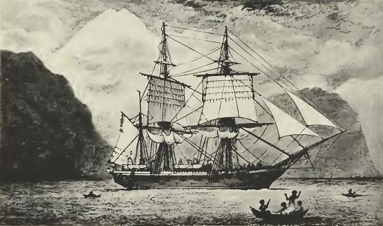
Fig. 15

Fig. 15. His Majesty's Ship Beagle hove to in the Strait of Magellan,

76 CALIFORNIA ACADEMY OF SCIENCES [Oc. Papers

      It is truly amazing that the modern chart of the Galápagos made in 1942 by the U.S.S. Bowditch, a vessel 380 feet in length and 6,000 tons displacement, equipped with every modern device for marine surveying, should so closely approximate the survey made by Captain Fitz-Koy over a hundred years ago. His little vessel was at the mercy of strong and uncertain currents together with deadly calms so prevalent in those regions. Certainly no greater tribute could be paid to the Beagle's commander.

      In this day and age when radar, wireless, sonic depth finders, and various other aids to navigation are commonplace aboard ships, those who have read Darwin's journals might be interested, and many are, to know what sort of vessel it was in which Darwin made his famous voyage and accomplished so much on that famous five-year cruise. The Beagle left England on June 27, 1831, and was paid off at Woolwich November 17, 1836.

      Designed by Sir Henry Peake, Surveyor of the Navy, she was launched at the Woolwich Yards, London, England, May 11, 1820. The Beagle was classed as a sloop, rigged as a brig, and had a displacement of 235 tons. The length of the gun deck was 90 feet; the length of keel for tonnage was 73 feet, 7 5/8 inches; the extreme breadth was 24 feet, 6 inches; the depth in the hold was 11 feet; light draught of water, forward it was 7 feet, 7 inches, and abaft it was 9 feet, 5 inches; the armament on the gun deck was 26-pounder guns and 8 18-pounder carronades. She carried a complement of 75 men.

      In 1808, some thirty small brigs were built for the Royal Navy, and a few more in 1813. The same design was used from 1818 onward, the last being the Termagant of 1837, so the Beagle came under this master plan of 1818.

      Like vessels of her day, she was stoutly built, her deck beams being approximately a foot in width and had what is known as a welldeck with t'gallant fo'c'sle and poop deck, the compartment below being fitted as a chart room. Although vessels of this size were sometimes steered with a tiller, the Beagle was fitted with a wheel. Captain Fitz-Roy made several suggestions regarding alterations while the vessel was being overhauled, and for the comfort of the crew the spar deck was raised twelve inches forward and eight inches aft. She had none of the modern inventions, such as turnbuckles for setting taut the standing rigging, this being done with lanyards and dead eyes with block and tackle as power. For bracing the yards, there were no pendants with luff tackles or double purchases, the braces being

No. 25] SLEVIN: THE GALAPAGOS ISLANDS 77

whips and power gained by more men tugging on the hauling part, and to board the main tack in a stiff breeze, even on a vessel the size of the Beagle, meant plenty of man power.
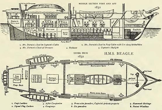
Fig. 16

Fig. 16. Detailed plans of H.M.S. Beagle.

      The main deck was given over to living quarters, the captain's room aft taking up the entire width of the stern. Forward of this were the officers' rooms along the sides and the midshipmen's quarters, and forward of these were the warrant officers' rooms and store rooms. A small locker, or bin, as it was called, took up the midship section, with the galley just abaft the foremast. The seamen swung their hammocks from the main hatch forward.

      The lower hold was given over to supplies, ammunition, coal, various stores, and that all important item, water. Even with the crew reduced to fifty-eight, when one stops to consider the vessel was only ninety feet in length, it can readily be seen that accommodations were anything but de luxe.

      The sail plan is not available and the drawing of the vessel made while in the Strait of Magellan does not show her with the royal yards in place, though it does show that she carried single topsails. Ten-gun brigs of the Royal Navy did carry royals, but in stress of weather or for various reasons, the t'gallant and royal yards were sent down and stowed in the shrouds. This was probably the case with the roval vards when the sketch was made.

78 CALIFORNIA ACADEMY OF SCIENCES [Oc. Papers

      The records show she remained at Woolwich until 1825 when she was allocated to surveying service by admiralty order of September 17, 1825. Her armament was reduced from 8 to 4 carronades and her complement from 75 to 58, while so employed.

      On September 27, 1825, the vessel was docked at Woolwich to be fitted for surveying Magellan Strait, copper taken off, sheathed with wood and re-coppered. Her rig was changed to that of a bark in order to facilitate her maneuvering, and on September 7, 1825, Commander Pringle Stokes became her first commanding officer. On his death he was succeeded by Commander William George Skyring as acting commander until Commander Robert Fitz-Roy took over until the end of her first commission, October, 1830, when she was paid off at Woolwich.

      During the second commission of the Beagle, June 27, 1831, to November 17, 1836, he took command once more and although he was promoted to captain during the cruise, and was eligible to command a ship of the first rate, he still continued his duties as surveyor in command of the Beagle.

      On fitting out the vessel for its cruise into the Pacific, Commander Fitz-Roy made many requests in order to make the vessel as comfortable as possible for the crew and to facilitate his work. That the admiralty had great confidence in him is shown by the fact that his many requests were granted even to the minutest details. The following correspondence with the Naval Board in regard to the outfitting of his command shows with what care he prepared for the voyage which ended so successfully:

[P. Rt. Adm. 106/1346 F. Off Capt Fitz-Roy (Lihon's Rudder) ]t
H.M.S. Surveying Vessel Beagle
Hamoaze. July 4, 1831.

Gentlemen:

      The peculiai' nature of the Service for which the Beagle is destined, — that of exploring coasts, little known, — in doing which she is, of course, very liable to accident of all kinds; — makes me feel more confident in asking you to order Lihon's Rudder to be fitted to her; — than would be the case under ordinary circumstances.

      I am aware she is too small a vessel to be thought worthy of the extra expense and trouble.

      Should you think pioper to favor the Beagle, upon this ground


      7 [Many of these letters bear file designations and comments as well as endorsements by officials, with or without their initials. All of these are enclosed in brackets so that they will be distinct from the original text. In a few cases the parenthetical material may be that of the author. — Editor.]

No. 25] SLEVIN: THE GALAPAGOS ISLANDS 79

and thus add to the advantages she already possesses — I shall be deeply gratified.

[(Endorsed) The Commander at Plymouth will cause the rudder to be fitted.]


[F. Off. 64]

H.M.S. Surveying Vessel Beagle
Hamoaze, July 14, 1831

      The Beagle being ordered to be fitted out for ———— continuing the survey of South America Capt. Fitz-Roy requests some small changes in the interior fittings suggested by my former voyage in the same vessel — — — — The manner in which the Chanticleer was fitted, having answered so extremely well leads me to hope that you will allow the Beagle to be fitted in some respects, similarly. [(Referred to Surveyor)]


[P.R.O. Adm. 106/1346 F. Off. 70 Capt. Fitz-Roy (Lightning Conductor)]

H.M.S. Surveying Vessel Beagle
Hamoaze, July 9, 1831

      I have the honor of requesting that you will consider of the propriety of allowing the Beagle's Masts to be fitted with Harris's Lightning conductors.

      In my humble opinion they are likely to be very serviceable & I earnestly hope that my request for them may meet with approval. [(Endorsed) Acquaint the Admiralty with this application & that the Board think it may be adviseable to comply with. W.]


[F. Off. 69]

H.M.S. Surveying Vessel Beagle
Hamoaze, July 9, 1831
[(requesting that the Beagle's upper decks may be "raised eight inches")] In examining this Vessel, the Offic ers of the Dock Yard have found that nearly the whole of the Upper Decks, — a great part of the Spirketting, — and the greater part of the Water Ways require to be replaced, being very defective.

      While repairing these defects I am assured by The Officers of the Shipwright's department in this Dock Yard that the beams, and the whole of the Deck may be raised and refastened at an expense which will not exceed one hundred pounds — and without more than one week's additional time being required for the repair of this Vessel.


[P.R.O. Adm. 106/1346 F. Off. 72 Capt. Fitz-Roy (Boats)]

H.M.S. Surveying Vessel Beagle
Hamoaze, July 9, 1831

      I have to request that you will allow four Boats be built at this Dock Yard for the use of — — — — Beagle, of the undermentioned

80 CALIFORNIA ACADEMY OF SCIENCES [Oc. Papers

descriptions, being the best calculated for convenient storage on the Vessel, and for the Surveying Service —

No. 1 Yawl — 26 feet in length
No. 2 Cutter — 23   "          "
No. 3 Whale Boat — 25   "          "
No. 4 Whale Boat — 25   "          "

      I have also to request that the Yawl and Cutter may be built on Mr. John's principle of diagonal planking; and that the Yawl may be fitted with the windlass invented by Captain the Honble George Elliot.

(Endorsed) "It has been usual to all Surveying Vessels such boats as are best calculated for the Service in which they may be employed —

The Beagle as a 10-gun brig is allowed Yawl of 26 or Cutter 25 feet Jolly boat of 16 or 14 feet Gig — 22 feet

by the establishment but the Committee of Naval Officers recommended Mr. John's principle of building Boats, to be confined to Launches.

[(Endorsed beneath by another hand) Give orders as requested by the Captain.]


[(Next ref. F. Off. 70)]

ers 69 (cont) Capt. Fitz-Roy (Enclosure in F. Off 69)] Report — ]

Plymouth Dock Yard
14 July, 1831

      In obedience to Minute of 13 instant, on the enclosed letter from Commander Fitz-Roy of the Beagle, we beg leave to acquaint you that as the greater part of the flat of the Upper deck, water-ways and Skirketting are more or less defective, and will require to be replaced with new materials, we are of the opinion that the alteration of raising the deck eight inches may be performed at an expense of £ 120, and as the space between Decks is only five feet, the storage as well as the comfort of the crew will be increased by making the alteration.


[F. Off. 66]
H.M's Surveying Vessel Beagle
Hamoaze, July 4, 1831

request to have the Beagle to be fitted with a Patent Windlass in addition to her Capstan, similarly to H. M. S. Chanticleer.

      I have also to beg that if you approve of the stove which was fitted on board the Chanticleer, and since transferred to the Phito you will permit a similar stove to be fitted on board the Beagle — — — it saves much room & much fuel.

[(Endorsed) Ask Mr. Fraser at that rate he won't supply a stove for the Beagle.]
[Surveyors as to Windlass — Desire the Woolwich Officers to for-

No. 25] SLEVIN: THE GALAPAGOS ISLANDS 81

ward to Plymouth — — — the patent windlass now on hand the Chanticleer to be fitted.]

[P.R.O. Adm. 106/1346 F. Off. 69 cont. Capt. Fitz-Roy (Raising Deck)]
[F. Off. 69 cont.]

      Commissioner Ross and the Master Shipwright authorize me to say that they approve of my proposal, — and consider that as so much of the deck requires replacing very little additional labour would be necessary to raise it entirely. If, however, the additional expense should be deemed more than proper: — I respectfully beg that permission may be granted for raising the deck: — and that I may be allowed to defray the expence myself.

      The Beagle is ordered to carry only two six-pound guns — therefore raising the deck will not be of consequence as respects the guns and their ports. By making this alteration the storage & comfort of the Vessel will be greatly increased — She will be much dryer upon deck: — Her waist will be less deep, — and as she carries only two guns — the stability of the vessel will not be affected, as might be the case if the guns were raised with the Deck.

[(Endorsed) Surveyor]
[(Navy Office 11 July 1831) The Board refers this letter to the Command, at Plymouth — — — he will cause a Report to be made without loss of time. G. Smith]
[Plymouth Yard 13 July 1831 For the immediate report of the Officers]
[14 July The Board are referred to the annexed report of the Officers. George Smith. Secretary — Plymouth.]
[(Endorsed) July 18 will comply with this request — — — in consequence of the service upon which she will be engaged.]


[P.R.O. Adm. 106/1346 F. Off. 85 Capt. Fitz-Roy (Awnings & Tents)
[F. Off. 85]

H.M's Surveying Sloop Beagle
Plymouth Dock Yard, July 28th, 1831

request for the undermentioned articles in addition to the regular establishment for vessels of her class.

A strong canvas awning for the main & quarter Decks, to be used only in sunny weather.
Two small "Bell Tents"
Two small Boat Tents made according to the enclosed plan.
A strong awning for one Boat (Yawl of 26 feet) made according to the enclosed plan.

      During the late survey we made these things on board, finding them so much wanted.

      My reason for asking for strong Main and Quarter Deck Awnings in addition to those usually supplied is that an awning used to keep off the sun soon becomes too thin to keep out rain, and as much of the Beagle's must be passed at anchor in very rainy as well as in hot latitudes — the health & comfort of all on board would be im-

82 CALIFORNIA ACADEMY OF SCIENCES [Oc. Papers

proved, and work carrying on in board materially forwarded by having a dry & sheltered Deck.

[(Endorsed) Approve of these things being supplied as this ship is going in a peculiar service.]


[P.R.O. Adm. 106/1346 F. Off. 99 Capt. Fitz Roy (Cables Anchors)]
[F. Off. 99]

H.M's Surveying Sloop Beagle
Hamoaze 18th August, 1831

Gentlemen:

      Having attentively examined some anchors, made upon Lieutenant Rodger's principles, & having heard the opinion of many persons qualified to judge of their merit: — I beg to request that you will allow the Beagle to be furnished with two Bower Anchors of 13 cwt. each: — (stock not included) made according to Lieutenant Rodger's method; in lieu of I. Bower Anchors of the usual construction.


[F. Off. 98. (Another letter regarding Anchors & Cables which are necessary for so long a voyage.)]

South America — and in the Pacific; including a return to England by the way of New Holland, and the Cape of Good Hope, — which service will probably occupy nearly 4 years — the Enclosed list which are greatly similar in number and size to those which the Beagle was furnished on her former surveying voyage & can be stowed with ease.

      Being obliged to anchor in — & work into, — or out of rocky unknown places, spare anchors & cables are absolutely necessary — while their purchase in foreign ports is both difficult and expensive.

      I have asked for chain cables of one hundred fathoms in length, because the water round about Tierra del Fuego and the West Coast of South America is generally deep — and I never found it prudent to bring the vessel up — or lye at anchor with less than 60 or 70 fathoms — where the water was deep and the bottom rocky — when it blew hard of course a much longer scope with required — to avoid break the anchor or parting the cable.

      Having parted from sixty fathoms of chain cable (which was afterwards crept up and recovered) during a severe frost — in the Straits of Le Maire, — and having seen several chain cables snapped at different times by bringing ships up with too short a scope — I am induced to beg you to grant this request.

      We had on board the same quantity on our last voyage — (Appended) List of Anchors and Cables requested for the use of H. M's Surveying Sloop Beagle.

Anchors
14 Cwt. (two being Rodger's if allowed)Five in No.
  7 CwtTwo  "    "
  3 CwtFour  "    "

No. 25] SLEVIN: THE GALAPAGOS ISLANDS 83

Cables
Chain (established size)400 fathoms
  Hempen do 250    "
  Splicing Tails for do 4 sets
  Hempen Stream do 200 fathoms

Also, in addition to the Hawsers allowed the Vessels of the Beagle's

Class —
Cables 6 inch100 fathoms
       "   4   " 100 fathoms
       "   3   " 100 fathoms

[(Endorsed) Give orders according to the Commanders request & acquaint him]


[P.R.O. Adm. 106/1346 F. Off. 97 Capt. Ritz-Roy (Hammock Cloth Tarpaulin)]

H. M's Surveying Sloop Beagle
Hamoaze, 18th August, 1831

[Asking for a fresh supply of Hammock Cloths]

      I am desirous of carrying out a spare set in addition to what is usually allowed. It would add very much to the cleanliness of the Lower Deck and Hold, as well as to the dry and healthy state of the vessel — if two Tarpaulins were allowed; for laying on the Lower Deck during rainy weather to prevent wet and dirt from being absorbed by the planks and working between the Hatches, injuring the cables & hawsers, and accumulating dirt in the Hold.

      These Deck Cloths would be used only during wet weather, and would be carried on deck to be cleaned 3 times a day — — —

      The Chanticleer and the Beagle always used Tarpaulins for this purpose during their last voyages when they could be procured. [(Endorsed) Let the Sloop have an add'l set of Hammock Cloths; but acquaint the Captain he cannot be allowed painted canvas for the Lower Decks.]


[P.R.O. Ad. 106/1346 F. Off. 103 Capt. Fitz-Roy (Sails & Spares)]

H. M's Surveying Sloop Beagle
Hamoaze, 18 August, 1831

Gentlemen:

      I have the honor of requesting that you will allow H. M.'s Surveying Sloop, under my command to be furnished with spars & Sails according to the accompanying list in addition to the present establishment for Vessels of her class. It is probable that the Beagle will be absent from England four years — and will be employed in all climates, without the means of obtaining supplies of stores; she can stow them with ease, an equal number were on board during her last voyage.

      I have also to reqviest that two small cooking stoves may be allowed for the use of Boats: — with Tarpaulins as allowed to ships

84 CALIFORNIA ACADEMY OF SCIENCES [Oc. Papers

employed on the Coast of Africa, & to the Beagle during her last voyage — [(Endorsed) When this vessel fitted out for the Surveying Service in 1825, she was allowed to take such stores as might be generally useful & such proportions as could be conveniently stowed, p. Adm. Order 17 Feb. 1825)] [List — Editor]

Top mastone in No.(either fore or Main)
Topsail Yardone in No.
Top Gallant Yard  "   "   "
Top Mast studding Sail
                        BoomsTwo in no.
Lower studding Sail BoomOne in no.

[P.R.O. Ad. 106/1346 F.Off.104 Capt. R. Fitz-Roy]

H. M's Surveying Sloop Beagle
Hamoaze, 24 Aug. 1831

I beg to inform you that the patent Galley Stove — made by Mr. Eraser of Shadwell for the use of the Beagle, — is furnished with an additional Bread oven — which I find increases the expense £ 17.

      As this oven will be of the greatest use in baking bread for the Ship's Company, I hope it will be allowed by the Navy Board without my paying for it myself —

[(Endorsed) Under the peculiar circumstances of the employment of this Vessel, the Board will pay this additional expense.]


[P.R.O. Adm. — Navy Board Ad. 106/1346 F. Off. 121]

H. M's Surveying Sloop Beagle
Hamoaze Sept. 20, 1831

I beg to be allowed the honor of mentioning to you that the ingenuous Compass, — lately invented by Lieut. Col. Graydon of the Royal Engineers, has not yet been tried in a small vessel, — & that if you approve of the instrument: — I should be very desirous of trying it's Merits.

      My own humble opinion — — — is that, if well made, it cannot fail to be of great Service in Foggy or hazy weather, or when, from any cause, the Horizon is obscured, though the sun is visible.


      [F. Off. 119]

H. M's Surveying Sloop Beagle
Hamoaze, Sept. 17, 1831

request for "His Majesty's Surv. Sloop B., under my command to besupplied with the under-mentioned "Metal Blocks", on Mr. Bothways construction in lieu of wooden Blocks.

Cat Blocksdoubletwo
 "         "trebleone
Signal Halyard BlocksSingleeight

One of the Cat Blocks is more than is allowed by the establishment; — I)ut it will be so useful as a Purchase Block; that I beg it may be allowed instead of a similar Block of Wood; — which would be much larger & liable to split & decay.

No. 25] SLEVIN: THE GALAPAGOS ISLANDS 85

[P.R.O. — N B 1831 /1346 (R.Fltz-Roy— N.B.)]

His Majesty's Surveying Sloop Beagle
Hamoaze Sept. 25, 1831

Gentlemen:

      With respect to the Ropemaker's warrant applied for in my letter of the 21st inst., — I beg to mention that the Beagle has an Establishment differing from that of Sloops; but Suited to the particular Service on which she will be employed, and as the Lord Commissioners of the Admiralty have authorized her to hire a Ropemaker, — I have to request you will grant a Warrant to the man named below
(John Borsworthick from H. M. S. Dublin)

[ \(Warrant Granted — )]


F. Off. 122

H. M.'s Surveying Ship Beagle
Hamoaze — Sept. 1831
      Petty Officers undermentioned — Warrants required.

Names Quality Entry Last Date of Where
Ship Passing Passed
Cert.
Wm. Wills Armourer 7 July/31 Adventure Not Gun Wharf,
9 Nov 1830 known Plymouth
Jno. Bos- Ropemaker 10/July 31 Dublin Lost in " "
worthick Late Thetis
twenties
Jas. Lester Cooper 16 Sept. Maidstone 21 June Victy Yard
1831 1817 Portsmouth

[P.R.O. Adm. — Navy Board /1346 (Robt Fitz-Roy to N.B.)]

His Majesty's Surveying Sloop Beagle
Hamoaze, Oct. 15, 1831

Gentlemen:

      With reference to your letter of the 13th respecting the Compass invented by Lieut. Col. Graydon: — I beg to mention that it is probable the Beagle will not sail from England before the 10th of November: — therefore I have hopes of being enabled to make trial of his Compass.


[F. Off. 129]

His Majesty's Surveying Sloop
Beagle           
Hamoaze, 8th Oct. 1831

I have the honor of requesting that you will allow the Patent Capstan of H. M.'s Surveying Sloop under my command to be returned into Store.

86 CALIFORNIA ACADEMY OF SCIENCES [Oc. Papers

      The excellent Patent windlass with which you ordered the Beagle to be supplied renders the Capstan unnecessary; and I find from repeated careful trials that it causes the Compass card in the Binnacles to deviate 10 degrees from their proper position: — owing to its iron spindle & mass of iron work.

      H. M.'s Surveying Vessels Adventure and Chanticleer had Patent Windlasses and never used a Capstan.

      The Windlass which is now on board the Beagle was in the Chanticleer during her last voyage (S. America, Cape Horn) and answered every purpose exceedingly well.


      [The following notations are also a matter of the Naval Board's record. — Editor.]

Anchors Est. of for Ships

Commr. of the Beagle applies for 5 anchors of 14 cwt. 2 of 7 cwt. & 4 of 3 cwt. — Aug. 18, 1831

Architecture, Naval — Improvements

Commander Fitz-Roy requests that Lihon's Rudder may be fitted to the Beagle Surveying Vessel.
Orders to Plymouth to do so — July 4, 1831

(Arrangements for fitting etc. Wm. Sharp Shipwright sent to Plymouth)

To be provided for the Beagle also Pintles & Braces (Prices)— Aug. 1831

Boats — Establishment of — for Ships

Commr. of the Beagle requests that a yawl, a cutter and 2 whale boats may be built for that vessel —
Orders to Plymouth— July 9, 1831

Boats — Awnings, Curtains & c

Commander of the Beagle requests she may be supplied with 2 small boat Tents, & with a strong awning for a yawl of 26 feet, according to plans sent
Orders to Plymouth— July 28

Boats — Improvements d Alterations

Commr. of the Beagle requests make yawl of 26 ft. & a cutter & 2 whale boats may be built for that Vessel —
Orders to Plymouth— July 9

Cables — Cordage Made of Iron

Commr. of the Beagle applies for 400 (tons?) of chain cable
Orders to Plymouth— Aug. 18, 1831

Capstans & Windlasses

Commander of the Beagle requests that she may be fitted with a patent Windlass, in addition to her capstan, similarly to the Chanticleer. Woolwich Officers to send to Plymouth the Patent Windlass now on the Chanticleer
Plymouth to fit it in the Beagle — July 4, 1831

No. 25] SLEVIN: THE GALAPAGOS ISLANDS 87

Compasses, Binnacles, &c

Commdr at Plymouth to issue to the Beagle 1 large and 1 small Prismatic, Surveying & Azimuth Compass invented by Mr. Schmalcalder. Commandr to report his opinion — Aug. 24

Commdr of the Beagle applies for one to be sent him — Sept. 20

Lt. Col. Graydon has ordered the Compass required for the Beagle to be put in head, l)ut it is doubtful if it can be completed in time — Acquaint Commandr of the Beagle
Commander states that he does not expect to leave England before 10th of Nov. & hopes it can be made in time
Acquaint Col. Graydon — Oct. 15

Fireheaters, boilers, cooking machines, stoves, &c

Commr. of the Beagle requests to be supplied with a stove similar to that ¦which was in the Chanticleer — now in the Pluto. Mr. Fraser to state price — July 4, 1831

Mr. Fraser will supply the Beagle with a firehearth similar to the Chanticleer's for £ 46.10s. Desires to send it to Deptford Plymouth to issue it — Commandr acquainted
Mr. Fraser to report when it will be delivered; it should be delivered by the 7th as there will be an opportunity of forwarding it on that day — July 19

Capt. requests two may be supplied. Portsmouth supplied. — Aug. 19

Commandr of the Beagle reports that the Galley Stove made by Mr. Fraser is furnished by his desire with an additional Bread Oven which adds £ 17 to the expense which he hopes may be allowed — Accepted — That under the peculiar circumstances of the employment of the Beagle the Board will pay the additional expense — Aug. 24

(Mr. Fraser had assigned his interests in firehearths to Beeston & Co., but had himself furnished the one for the Beagle — the Navy Board "have nothing to do" with a private arrangement — Dec. 9


      From 1660-1685 men-of-war other than first rates, used the crowned lion as a figurehead, and it was not until 1689-1702 that the privilege of individual figureheads was extended to second rates. In 1727 the Admiralty authorized the use of appropriate figureheads in smaller ships, so taking advantage of this privilege the head of a Beagle was fitted to Darwin's ship, the vessel that was to be his future home for so many months. When Darwin saw the Beagle, he remarked:

88 CALIFORNIA ACADEMY OF SCIENCES [Oc. Papers

      She looks most beautiful, even a landsman must admire her. We all think her the most perfect vessel ever turned out of a dockyard. One thing is certain, no vessel has been fitted out so extensively, and with more care. Everything that can be made so is of mahogany, and nothing can exceed the neatness and beauty of all the accommodations.


      Fitz-Koy's official inventory informs us that there were lightning-conductors on all masts, the bowsprit, and the flying jib-boom. Upon each quarter hung a whale boat twenty-five feet long. In addition, a stout dinghy was carried astern. Seven brass guns were mounted on deck; one on the fore-castle, two before the chestree, and four abaft the mainmast; five of these were six pounders, and two were nine pounders.

      When the Beagle completed her second commission, under Captain Fitz-Koy, she was paid off at Woolwich on November 17, 1836. Remaining idle but a short time, she was commissioned for her third cruise on February 16, 1837 for a survey of the coast of Australia and Bass's Strait under the command of John Clements Wickham, who was invalided home and succeeded by John Lort Stokes. On completion of this cruise, she was again paid off at Woolwich on October 14, 1843. She was then transferred to the Commissioner of Customs, by Admiralty Order of April 1845, for service as a Watch Vessel at Southend and was employed subsequently at Paglesham. She received distinguishing number "7." On May 13, 1870, the Beagle was sold at public auction to the shipbreakers Murray and Trainer for the sum of 525 pounds. Thus ended the career of one of the Royal Navy's famous ships.

      The Beagle's commander, Robert Fitz-Roy, had a brilliant career in the Royal Navy. Born at Ampton Hall, Suffolk, he entered the Royal Naval College at Portsmouth in February, 1818. On October 19, 1819, he was appointed to the Owen Glendower cruising on the South American coast, and in 1821 he joined the Hind and served two years in the Mediterranean. In 1825 he served on the Thetis, and in 1828 he was made commander of the Beagle. Though on December 3, 1834, he was promoted to the rank of captain and was eligible for command of a larger vessel, he remained in command of the Beagle on surveying duty.

      He was promoted to Rear Admiral in 1857 and Vice Admiral in 1863. In later years, he became Governor of New Zealand and Chief of the Meteorological Department of the Board of Trade.

      Finally overwork caused his collapse and prompted him to end his life at his residence at Norwood, Surrcv. in June, 1865.

No. 25] SLEVIN: THE GALAPAGOS ISLANDS 89

VOYAGE OF LE GENIE

      The remarks on the climate and the comments on the work of Captain Robert Fitz-Roy, R.N., together with the reports which it contains concerning the sounding of the crater lake at Tagus Cove and the experience of watering his ship at Freshwater Bay, make most interesting the following rather literal translation of the account of the visit of Henri Louns[sic Louis Henri], Compte de Gueydon, who, while in command of the French brig-of-war Le Genie, made a visit to the Galápagos Islands which lasted from August 7 to September 17, 1846.


Exploration Made in August and September, 1946[sic 1846], by
Capt. de Gueydon Commander of the Brig
Le Genie

Admiral:

      On August 6th last, you gave me the order to set sail the next day and steer course directly toward the Galápagos Island Archipelago for the purpose of exploring those islands and then to be able to give you all information requested by the Minister in his message of September 17, 1845, of which you sent me a copy together with a letter from the Consul for France at Guayaquil to the Minister of Foreign Affairs, a translation of a note published in the Gazette of Ecuador and the summary of information furnished by Admiral Dupetit-Thouars following the circumnavigation trip of the frigate La Venus.

      Convinced by the reading of all those documents of the importance of the work you have intrusted me with, I set myself to study the place, to gather all the trustworthy information of which I am capable.

      I have seen many things myself. I have taken great pains, but I do not regret it if the result of my investigation and my observations which I shall have the honor of presenting to you. may help you to clearly inform the Government of the King on the question he has asked you.

      Before going any further and before starting my narrative, I think it is useful to mention the different names under which several of the Galápagos Islands are known, because this multiplicity of names may bring errors or at least throw some incertitude on the information and descriptions given by different travelers who have visited the islands and who finding them uninhabited they all thought they had the right to baptize them. . . .

      Called the Enchanted Islands by those who discovered them, the Galápagos Islands have since then received their present name which is more appropriate because it owes its derivation to the immense population of turtles found there.

      The island of Santa Maria de la Aguada is indicated on Capt. Fitz-Roy's map under the name of Charles and since then has received from Mr. Villamil that of Mercedes, the name of General Flores' wife.

90 CALIFORNIA ACADEMY OF SCIENCES [Oc. Papers

      The next island has five names: James, Norfolk, Porter (name of the American Commodore who visited it), Indefatigable (on the English maps), and at last baptized by Mr. Villamil, Bolivia, in honor of General Bolivar under whom he served.

      James Island on the English map. formerly called Santiago, which was simply the translation of the English name, has received from Mr. Villamil the name of Olmedo.

      All the other islands, less visited, have kept up to now the names as given on the English map. I shall preferably use the names given by Mr. Villamil, for it seems natural and fair to me that one should let everyone baptize his or her own land.


Navigation — Hydrography

      On August 7 last after losing sight of your flag, I followed La Brillante for 24 hours during which Le Genie constantly had a decided advantage of speed; then, realizing that the route of La Brillante was taking me too far away from my own route, I signaled free course and I proceeded directly toward the Galápagos in sight of which, pushed forward by a gentle breeze varying from S. to S.E., I arrived on the 14th at dawn.

      During this short voyage the sky was always cloudy or at least stormy; but nevertheless the weather looked to me so steady that I did not order the top gallant and royals down from the masts.

      Notwithstanding that on the 14th, being near land and having seen Hood Island since dawn, I could not start before nine o'clock in the morning, at which time the very thick fog that covered the island disappeared, thus enabling us to distinguish the coast. Then I made for Mercedes Island in order to start my exploration by verifying as especially requested by the Minister, the assertion published in the Ecuadorian Gazette that there was a closed bay in that island which was accessible to vessels of any size.

      After cruising very near the coast from point S. down to point W., in other words, that portion facing S.S.W.. and thus ascertaining myself that there was no port on that coast, I weathered the point W. and almost immediately I saw two vessels anchored. One, an American whaler, was very close to shore; the other, a small schooner flying the Ecuadorian flag, was anchored way back in a small cove, facing three or four huts one of which was also flying the Eucadorian flag.

      The shape and the position of the cove and the existence of breakers between the schooner and my ship answered quite well the description given by Mr. Villamil, consequently I assumed that that anchorage, notwithstanding its poor appearance, must be the Porto Cabello so much boasted about, and so I maneuvered toward anchoring.

      However, in order to be more certain, I sent a boat to gather information while by means of another boat I ordered some soundings at the entrance.

      Shortly after, when I was in the channel, my first boat returned from shore bringing a certain Guillermo Guerney, English born

No. 25] SLEVIN: THE GALAPAGOS ISLANDS 91

established at the island for several years. He cleared all doubts and offered to serve as a pilot. I accepted.

      After a few rounds so short that several times I was compelled to tack about, even before being able to trim sails, Le Genie anchored at the center of the cove, twelve meters deep, white sand bottom.

      Porto Cabello is that small cove very plainly indicated at the point W. of the island on Capt. Fitz-Roy's map. It has been known for quite some time under the name of Bahia de los Servida, in English Wreck Bay; on the map of La Venus it is even indicated under the name Baie du Naufrage, but it is poorly placed.

      During the first two days of my stay at Porto Cabello, the fresh winds were blowing, and although they came from inland, the sea rounding the point would come rolling with force on the banks and then enter the bay as a well rounded surf breaking with force on the shore. There was, however, no danger for the vessel as the bottom was good and the surf was on the edge. But communications were difficult, even on the fine sand beach at the back of the bay. The rest of the time, the sea has been calm and it seems that it is always more or less the same.

      One way or the other, Porto Cabello is not a port and the name Wreck Bay fits better this cove which, in reality is just good for small coasting vessels. The haven, when one is able to anchor, is hardly three cables wide by four cables long and in order to arrive there, one has to sail with the wind into a passage one third of a mile wide, the only one known, or against the wind between the banks full of sharp edges in a channel one cable length wide which we have discovered. The Minister's special recommendation has made me decide to sacrifice one week in order to draw a good map of Porto Cabello, which better than any description will show you what in reality that anchorage is.

      The nearness of the watering place, an advantage indicated by M. Villamil in favor of Wreck Bay, is almost illusory, for although it is some ten miles distant it is often quite difficult to reach it on account of the winds and currents which almost at all times are against you; my launch which had started one morning at four o'clock returned at sunset without having been able to round a first point only two or three miles distant. A second time, the launch started at three o'clock in the morning with a native as a pilot; it arrived at the watering place at five o'clock in the afternoon. Being that late and because of the condition of the sea, the launch had to return without water.

      Quite worried about the water question, I ordered the digging of a well at some sixty meters from the seashore at a low spot. I promptly found some water, but it was so terribly salty that it was practically like seawater. A little further away from the seashore it might have been fresh, but it would have been necessary to dig a much deeper hole and it could not be done and I preferred to go myself with the brig to get the element at the watering place of Fresh-Water.

92 CALIFORNIA ACADEMY OF SCIENCES [Oc. Papers

      If this island were inhabited, it would be easy to bring water to the seashore because there is plenty of it in the upper region and not very far away, at only a few miles distance, but if one would undertake that work, it would be much better to bring the water to Stephens Bay, which is a good and spacious anchorage, than to bring it to Wreck Bay.

      August 22, at dawn, the map being finished, I set sail and before going to visit the other islands I made for the watering place cove in order to survey it and complete my water provision. With only ten miles to go, I figured to drop anchor at 8 or 9 o'clock in the morning, load water during the day. and leave in the evening, but it was not so; and although the breeze was good. I came to back about the reef that I had left in the morning; the whaler which I mentioned above and which had left the day before appeared a little afterwards at a good distance under the wind. There was an adverse current of from 2 to 3 knots.

      Then I tried to tack very close to land and it was all right, but. during the night prudence not allowing me to remain at such short distance, I got away and the next day I anchored at the point that is half way. although the bottom at that spot facing squarely the coast is quite bad, but I had to do it in order to avoid being swept away as the wind had slacked considerably.

      Very near the watering place, I sent my launch which, this time, brought me a good load of water returning to get some more; but during that time I had made an important discovery. All along the coast the current changes with the tide. The next day. the 24th, early in the morning I took advantage of a favorable current and reached the anchorage at the watering place.

      This bay of the watering place or Fresh Water is entirely open to the predominant winds; the bottom is large and deep near the coast. I think it is a safe anchorage for the greatest part of the year.

      That part of the coast that forms this bay is much greener than the one under the wind; each little ravine has its more or less abundant stream, the one which is easier to reach and where one gets the water cannot be seen from the sea; the ravine is very deep. A long while l)efore reaching the shore, the water runs horizontally and even forms a sort of small pond which is separated from the sea by a bar of rocks through which the excess of water flows. There is a little bridge for the boats which is very clearly indicated on the English Map and which could be made safe and serviceable with little work.

      Further to the East there is a waterfall; it is a stream that reaches the coast at a point where the cliff allows it to drop some ten or twelve meters in two gushes each representing four or five inches of water.

      Here, as at my preceding anchorage, the currents changed with the tide and thereafter I had the occasion to make the same observation everywhere.

      August 25th, with our tanks full, I set sail at 8 o'clock in the morning heading for Floriana. On our way I had the Mac Gowen reef sur-

No. 25] SLEVIN: THE GALAPAGOS ISLANDS 93

veyed near which we were at noon, time for the observation of the latitude.

      I have clearly seen and recognized the two heads of rock that are marked on the English Map: we passed them at about two cable lengths at the very most. Their latitude is correct as well as the survey and bearings taken from this point on Barrington Island. These rocks are almost level with the surface of the water, the one to the west is, however, less submerged than the other. They are not dangerous during the day, for they are clearly evident, but at night they are, as the currents are neither adequately known nor sufficiently regular to be accurately predicted.

      Leaving behind me the Mac Gowen reef, I soon arrived in the midst of the islets which encircle Floriana, and after having passed, as close as possible, Watson Islet (or Enderby), which is shaped like a sugar loaf completely perpendicular, then in the very narrow channel formed at the point North of Floriana Island by this same point and a little islet. I came, rounding the inner bank, to anchor in the bight of Saline Bay (way inside of the bay) near the West coast, ten fathoms, white sand bottom.

      Post or Saline Bay is a good anchorage; there, one is well sheltered from the reigning winds but the bay has no watering place and notwithstanding what the inhabitants say, I do not think it is possible to bring water to the place, for there is not adequate water in the interior of the island where one will only find springs that do not even give birth to the slightest brooklet.

      Floriana Island being the only island that has really been explored by Admiral Dupetit-Thouars, while on board La Venus, I would not have to study if it had not been because I noticed considerable discrepancies in the shape and especially in the orientation given this island by Capt. Fitz-Roy on one side and M. de Tessan on the other.

      After having ordered many surveys regarding points and islets and also some azimuths in Saline Bay, I realized that the map made in 1838 by M. de Tessan was better oriented and that on the English map the position of the island was affected by an error almost equal to variation. It seems that it was observed by compass and that they forgot to correct the variation, for, turning the island around on itself nine degrees toward the East, Saline Bay is well oriented and all point positions come close to those given in M. de Tessan's map.

      As to the drawing and various details regarding the coast, the English map is far superior to M. de Tessan's plan. One can tell that Capt. Fitz-Roy saw everything, and quite closely, while M. de Tessan just went by.

      The opinion I have just given is the result of an exploration by launch by my assistant M. Forget, from Saline Bay to Gardner Islet from the south, and by me from the same Bay to the east point where there is a small cove at the entrance of the ravine formed by the Las Cuevas Mountains, where, according to the natives, some buccaneers

94 CALIFORNIA ACADEMY OF SCIENCES [Oc. Papers

had established themselves in natural grottos that one still sees but that to me look too small for the purpose mentioned above.

      On August 30th, having nothing else to do at Floriana. I left at six o'clock in the evening and I ordered the course to be set so that next morning, at dawn, we would be facing the south coast of Albemarle. I had not yet decided which side I would visit first. I was inclined to start with the eastern portion which would allow me to take some bearings regarding Bolivia and Olmedo islands and then to round the north point of Albemarle in order to return under the wind. This last part seemed to be rather difficult to perform in that narrow channel separating Narborough from Albemarle where the English map indicates a reverse and steady current of one and a half miles per hour. Undecided, I left it to fate to choose and on the 31st, at dawn, the winds being a little more east than usual, and the current having dragged me a little more west of Cape Rose, I cast off to round the island by the West.

      After passing Essex Point, I entered the Bay of DiguanaI which is a detestable anchorage. The coast, at this point, is very high, but arriving at, and after passing that point, the coast is very low.

      Once arrived at Christopher Point, an immense plain covered with small volcanic cones and lava unfolded to my eyes. It was so odd that I decided to stop in order to have it surveyed. While my launch was at the shore, I continued along the coast, always at a few cable lengths so as to see every detail. This navigation, moreover, did not offer any danger, all winds coming from shore, but the coast, although very low, falls away so abruptly that one cannot anchor even only a cable length from shore. Night drawing near, I stopped to wait for my launch. I had at that time reached the last point preceding Elizabeth Bay.

      Next day at dawn, to my great astonishment, winds became northern and remained so until eleven o'clock at which time, changing to south, they allowed me to head toward Tagus Cove where I wanted to anchor. As I arrived at the entrance of the channel, I had again some north winds and behind me I could see the demarcation line of the south wind. Consequently I had to maneuver, and as the breeze was weak, I kept close to the coast of Albemarle, fearing being carried away beyond my anchorage by currents that I judged strong. This precaution was completely useless, for it was not long before the current changed, and from that time on, having sea and wind against me, I did not gain any and tacked until midnight without being able to reach the Tagus anchorage to which I had sent a launch with a lantern in order to be able to locate the entrance which was difficult to find because of the obscurity of the bight and the confusing highlands which form this little haven.

      After midnight, the breeze ceased completely. I had my launches pull me and thus I was able to come quite close to the coast, a little south of the port so as to anchor about a cable length from shore.


      I Iguana Cove.

No. 25] SLEVIN: THE GALAPAGOS ISLANDS 95

      As soon as I anchored, the current reversed again, but as we all needed rest, we all went to bed and the next morning;, wind and sea being favorable, I entered easily and dropped anchor in the middle of Tagus haven.

      The map of Tagus given by Capt. Fitz-Roy is remarkably exact even in its smallest details. In this haven, the sea is perfectly calm; one could careen there and it is, properly speaking, the only port that exists in the island. But it is very small, inlaid between mountains so high and so steep that one cannot land except at the mouth of a stream which is exactly at the end of it and to the right.

      The small salty lake indicated on the map is extremely remarkable. It has a circular shape and is the bottom of an immense crater, the edges being so steep that it is very difficult to reach the water. However, by means of ropes I let a bore go down to sound it. One found four fathoms at a short distance from the edges and five and a half in the center. Its largest diameter is 380 m. and the smallest 350 m. If one could cut the ridge that separates it from the port, it would make a very beautiful dock, but the job would be considerable, because this portion, although narrow and the lowest one, is still some fifty or sixty meters high.

      Tagus is like the anchorages at Floriana and Mercedes; it has absolutely no water. There are, however, at the Eastern point of the entrance, toward the South, two places where a few drops of water ooze through the rock, but one would have great pain trying to collect a few liters per day and, still, this water is not so fresh notwithstanding it comes from a point higher than the sea level.

      The North Coast south of the heights in the middle of which Tagus is wedged, is very low and offers the same aspect as the Point Christopher region: small craters of lava scattered in all directions. The Coast of Narborough forming the other side of the channel is possibly still lower and, remarkably, one cannot touch bottom near the lower portions while one can anchor on both sides of the entrance of Tagus all along the high and steep ones. The same applies to the anchorage at Iguana at the point West of Albemarle and to other regions of these islands.

      During my stay at Tagus Cove the north and south winds would alternate: in the morning the south wind would blow and the north wind in the evening. Currents would also follow the tide.

      These observations have led me to realize that it is equally easy to head toward either Cape Berkeley or Point Christopher and, regretting that I did not start from the east, I was forced to come back in order to explore the S. E. Coast of Albemarle which had been described to me as the only one having any importance because of its fertility, but at the same time as a dangerous and almost inaccessible coast.

      As I came to that decision I set sail on Sept. 3 at 4 o'clock in the afternoon, and with the aid of a little breeze N. N. W. I left the channel shortly after the wind changed to W. S. W. and continued to change; but the currents being less felt in the gulf formed by the Albemarle and Narborough islands, I arrived very easily at Christopher

96 CALIFORNIA ACADEMY OF SCIENCES [Oc. Papers

Point where I found with the regular winds all the difficulties that I had encountered when I went up the bay to the watering place at Mercedes: the winds increased during the day, and keeping very close to the coast I hung out with difficulty during the night, and there remained belore me two days of painful tacking to round Cape Rose, that is to say to make ten miles in the face of the wind.

      After rounding Cape Rose without bothering about the reputation of the windy coast of Albemarle as depicted to me, and fully trusting Capt. Fitz-Roy's map. I followed the entire E.S.E. coast of this island at a distance of one mile and often less, going into every bight and surveying every rock and at night I came out between the Crossman Islands near which I stayed until next day.

      The rocks marked in the E. 1/4 N. E. of Cape Rose and north of Brattle Island are steep and above water. Brattle Island and Crossman Islands seem to be old craters; they are steep also. The coast of Albemarle is low and good, although the sea breaks in with force. Only the points might be dangerous, especially at night, for they are so low that quite often one will see the breakers before seeing land. For this reason one might conclude that the reefs are quite distant from shore if, following his first impression he would get away too soon. Summing up I may affirm that over the entire distance I have travelled there is nothing that resembles a port.

      On the 7th of September at dawn I left the coast of Albemarle coming over to the coast of Bolivia. I passed very near Nameless Islet which is quite high and steep.

      Heading then toward the coast in order to navigate closely along it, I saw two or three huts at the foot of a knoll marked on the map in the middle of the western portion of the island facing Duncan Island, and a three-masted American whaler that was anchored very near the coast in front of the huts. When I came near the whaler, I sent a launch to gather information and thus I learnt that at that place only there was a path leading to the interior of the island. I dropped anchor near the whaler, ten fathoms depth and about 1/2 mile from shore.

      At that spot, which is not sufficiently far out leeward from the island, the sea is agitated without being rough, but from that point on one can anchor most anywhere. Conway Bay is three miles distant in the N. N. E. This bay is not the best anchorage. One is beyond there.

      There is no water near the coast and the few individuals who live at the seashore are compelled to go ten or twelve miles in the interior to fetch some from where it is very abundant. If the island should become important, one should bring water to the main anchorage which is also the one nearest to the spring and the fertile portion of the island: but this was unknown to the first settlers who today still remain at that place because of their huts and the path which they use for the exploration of the interior.

      General Mena, who came from Mercedes to Bolivia for the exploitation of turtle oil. had indicated to me a certain spot near the sea where he though that by digging deep enough I would certainly obtain

No. 25] SLEVIN: THE GALAPAGOS ISLANDS 97

some water. I decided to try the experiment, but after having drilled a layer of vegetal soil, rather clayish, of some 60 cm. thickness we found such a hard rock that because of lack of tools and time we were compelled to give up our attempt.

      At last, on September 11th, back from my exploration in the interior, I set sail leaving for the bay indicated on the map, within Cape Barrington of Albemarle Island and in which Capt. Fitz-Roy does not seem to have entered, for he does not give any soundings besides those marked at the point of the entrance.

      After rounding Cape Barrington at a good distance in order to avoid the reef and the white shoals around it, I returned toward the south, but the bottom having promptly jumped from 15 to 10 fathoms, I anchored in order to take soundings by means of launches before proceeding any further.

      At four o'clock in the afternoon my launches returned reporting that they had found ten fathoms everywhere even to the water edge. The sea was perfectly smooth and I was surrounded by land on all sides. Everything was telling me that at this spot we had the best and even the only road in the islands and I was therefore unable to understand why Capt. Fitz-Roy had ignored it. I decided to stop to, at least, make a good sketch of it and in order to make the job easier, I dropped anchor at 1/2 mile from the coast way inside Cape Barrington.

      M. E. Cellos, aided by Messrs. Jamin and Meynard, made the map that I enclose together with this report, it is as accurate as the little time that was possible to give to the work has permitted.

      Hydrographical work has confirmed my first impression. The bay I have been speaking about is a quite beautiful road sheltered from all the winds that blow with a certain force. Its entrance at the point where I am anchored was only 75 degrees and in the middle of it Olmedo Island is situated. The bottom, however, is not very good, for although the sounding lead often indicates presence of sand, I am inclined to believe that the real bottom is lava covered by a thin layer of sand, because, when my anchor came up without the stock, I saw on the flukes some striped marks indicating the presence of a hard bottom.

      The coastline is covered with mangroves and very high trees unknown to me. This gives the coast a very romantic aspect, but as soon as one sets foot on shore the illusion is of short duration. Beyond the rather thin border one finds an immense plain of lava and scoria.

      All along the coast, one finds small ponds covered with teal, and in the interior one finds everywhere traces of water; in the crevices one finds the kind of plant that grows in the bottom of wells, all of which proves a great humidity and the presence during a large part of the year of reservoirs of fresh water.

      The water of the salty ponds near the sea becomes briny and then almost fresh at a short distance from shore, beyond where there is no more water to be found. This, added to what I said before, makes one believe that digging further, away from the sea, one would find fresh water and in abundance.

98 CALIFORNIA ACADEMY OF SCIENCES [Oc. Papers

      The less briny water that we found, cooks vegetables well and is drinkable. But it is not agreeable and in reality it is not fresh enough to be considered for drinking purposes.

      When I left, I went around the road on the side of the isthmus and I found the bottom very even. It is a little larger here than at the point where I anchored.

      So after navigating for some time and for the last time a portion of the coast of Albemarle, I turned to starboard and headed toward Cape Nepean of Olmedo Island which I sounded very closely as far as James Bay where I dropped anchor by 8 fathoms deep, white sand bottom fringing a sand beach and lagoons indicated on the map.

      After dropping anchor, I went to visit the watering place indicated on Capt. Fitz-Roy's map and I found it as described. Nothing escaped the perspicacity of this conscientious observer: the smallest holes, the smallest details are all indicated with really astonishing precision and following his drawing one can visualize in the most accurate manner the shape of the coast. Coming after him. there is not even an opportunity to glean; consequently as to hydrography I am not reporting anything new besides the map of the road of the isthmus, but I hope to be able to inspire such confidence in the work of that hydrographer that one shall be convinced, as I am myself, inspecting his map, that there does not exist anywhere in the Galápagos Archipelago a port that really deserves that name. I assert this as far as the portion that I have visited is concerned, comprising more than one third of the total length. One might find a few holes like Wreck Bay between Cape Woodford and Cape Barrington or little further north, or maybe also on the south coast of Bolivia; but one will not find a port in the real acceptation of the word, at least I think so.

      The watering place at James Bay is a quite beautiful spring of delicious water which comes from a sandstone mountain, just close to the seashore. Digging a reservoir of a certain capacity large enough to receive the whole amount from the spring, there would be enough water to supply all whalers that might call at that port, even at this season which is the driest of the year.

      Today the greater part of the water is lost in the sea and one cannot obtain it but at two small holes dug by man's hand. One of these holes contains 65 litres and the other 7; they furnish at this time of the year 1.200 litres of water per day. Higher up in the ravine that separates the two sandstone mountains and that serves as bed to a stream during the wet season; I have seen another small spring at over sixty meters above sea level.

      Everywhere in the mountain which is very steep on the side looking toward the sea one sees traces of dried up springs and even some wet spots. Everything indicates that one could get there a good watering place. The only thing needed would be a little work with no difficulties to surmount.

      Unable now to prolong my stay in the islands without going beyond the time allowed me for the exploration, and besides having

No. 25] SLEVIN: THE GALAPAGOS ISLANDS 99

visited all the islands that because of their size or fertility had any importance — the others being mere sterile reefs, I left James Bay on September 17 at eight o'clock in the morning; but I left the archipelago definitely the next day as on the 17th I was engaged surveying the east portions of Olmedo and Bolivia islands.

      Now that I have reported on my navigation and have given my opinion on the degree of confidence that one may give these observations, I only have to report further on the purely nautical part of my mission, to sum up what I said regarding hydrography and present a few general considerations on seasons, wind, and current.

      All the Galápagos Islands are elevated at their centers and may be sighted from far away when their summits are not engulfed in clouds as they are most of the time; the land slopes down gently toward the seashore where it forms exceedingly low points sometimes almost submerged. There are, however, some places where the coast is high and steep and usually it is at the foot of these elevated portions that one finds a good bottom for anchoring.

      The seashore is not treacherous as a rule and one can run very close to it with security even when the wind is blowing and the sea is breaking with force.

      Practically all the hazards are evident; the huge rocks which project to various elevations, fall away abruptly to great depths.

      There is no closed port in the whole archipelago, but under the winds from the islands there are many good anchorages. The most beautiful road is the one at the isthmus; there one finds coves where one can careen very well. The fear inspired by the windy coast of Albemarle and by the sand bar at Cape Barrington has, undoubtedly until now, kept away all vessels, for we have not found there on land any trace indicating the passage of men, while everywhere else we have seen here the grave of an American captain, there some cut trees, someplace else ashes, in other words we are convinced that others before us have visited the same places.

      Finally, Capt. Fitz-Roy's map makes the navigation of the archipelago easy and not very dangerous. That map is, as a matter of fact, remarkable in its accuracy of the relative and absolute positions of the islands and perhaps much more by the truthfulness of all the details that have not escaped his minute investigations, and if one notices here and there, and especially at Floriana, some slight errors regarding the situation of the points, it is undoubtedly because the details were made by compass. Be as it may and notwithstanding those imperfections, that work is above most all the others we have in our possession, and comes immediately after the beautiful maps of M. Beautemps-Beaupre.

      At the time La Yenus called, the islands had been inhabited only for a little time, consequently the seasons were not well known and undoubtedly that is the reason for the error into which Admiral Dupetit Thouars fell. The Admiral had only theoretical considerations for a guide.

      Although the sun passes twice at the zenith at intervals almost equal, there are not however two summers and two winters. There

100 CALIFORNIA ACADEMY OF SCIENCES [Oc. Papers

are really but two seasons as in the Antilles, i.e., the dry season of general winds and the rainy season with stormy and quiet periods.

      The season of general winds, the beautiful season, the one called summer, begins in May and ends in December. During those eight months, winds blow steadily from S. to S.E., a fine wind. When this meets the land winds, a lot of clouds are produced, and the summits of the islands are shrouded in clouds and vapors that produce great humidity. It rains there during a great part of the day, without a single drop of water coming to refresh the dried up lands of the seashore; only during the months of July and August, dew is more abundant and a damp fog covers the land until ten or eleven o'clock in the morning, a circumstance very annoying to navigators, one that has inconvenienced me often. The month of October is the driest of all; it is then that the lowest small ponds dry up compelling the inhabitants to go a few more miles to fetch the necessary water for their consumption.

      Winter, that is the hot and calm season with variable winds, rains and storms, begins in December extending to May which perfectly corresponds to the period of the year during which the line of equatorial calm advances more toward the south. During that season, winds blow often from the west and sometimes from the north, but never too strong nor for a long time, making the different anchorages of which I have spoken dangerous. The road on the isthmus is also at that time the best; abundant rains inundate the low regions of the islands, while through some sort of compensation the summits are usually cleared and receive in total less water than in the other season. As for the plateaus, winter is the dry season.

      I have given all the imaginable care to verify those facts. I did not go by the opinion of the more learned; I have consulted laborers and other men of the people. All agreed entirely and some of them have lived in that country for the past twelve or sixteen years.

      Experience, furthermore, has confirmed my assertions, for as La Genie was at the islands at the end of August and beginning of September, we should have experienced calm weather, great heat, rains, in one word the beginning of one of the two winters. But such was not the case. To the contrary: it was constantly rather cool instead of warm, the thermometer did not go above 22&ddeg; centigrade and the average temperature was 20.8°. It did not rain. There was no storm and there was not one calm day; no other wind blowing from a different direction but the trade winds.

      During the summer the currents are almost steady and westwardly of about one mile per hour. During the other season they are very variable and even eastwardly at times and very violent. Here is an example that endangered the life of the most important inhabitant of these islands:

No. 25] SLEVIN: THE GALAPAGOS ISLANDS 101

General Mena who had left Floriana to come to Mercedes with several laborers and a woman was overtaken by night in mid channel. Counting on the usual direction of the current he did not worry and went to bed. Next morning when he woke up, land had disappeared and they had for food only cowhides and sky water.

      Twenty-three days later, their frail whale boat, half sunk, was picked up by an American fisherman 200 miles east of the island. They were almost dead. I would think it difficult to understand how they were able to exist during those long days. The incident has been reported to me by several of those who were there.

      Wind and current deviate from their natural directions through the islands that are on their course, to produce some effects that I shall indicate for the sake of navigation.

      Under the wind of the large islands, one finds variable winds and even north breezes. Within the angle formed by the two portions of Albemarle, the effect is quite evident and considerably aids navigation. Currents are weak and variable leeward of the islands, where they acquire a velocity of two and three miles along the coast E. S. E. and W. N. W. There, with the regular free winds, it is very difficult to sail to the wind and round the points that fortunately are not long.

      Very near shore currents change together with the tide, which also makes its influence felt out at sea.

      During part of the summer the only watering place where one can get a considerable supply of water is at Fresh Water, Mercedes Island. With little work, the watering place at Olmedo, without any particularly abundant volume, could supply all whalers and war vessels of medium size.

      During winter one finds water everywhere and I am convinced that, several months after that season, the watering place at Olmedo must still give plenty of water.

      Finally: One finds everywhere with extreme easiness, a good supply of fire wood and sand.


VOYAGE OF THE CORVETTE DECRES

      On the cruise of the French corvette Decres to the Galápagos Islands, two anchorages were plotted by Passed Midshipman Estienne. These were Wreck Bay, Chatham Island, and Black Beach Roads, Charles Island. The following- rather literal translation of a description of Charles Island as it was at the time of the Decres' visit and as given by the commanding officer is of great interest to later visitors:

102 CALIFORNIA ACADEMY OF SCIENCES [Oc. Papers

Fig. 17

Fig. 17. The French Navy is represented in the Galápagos surveys by the chart of Black Beach Roads, Charles Island, made in 1887 by Passed Midshipman M. Estienne of the corvette Decres.


NAVY DEPARTMENT

Carton 81 – No. 248
Pacific Ocean Division:
1887
EXTRACTS FROM A REPORT OF THE SEA
by the Commander of the DECRES

From Panama to Galápagos

*  *  *  *  *  * 
I maneuvered in such Saturday, May 14th, at 6 o'clock in the morning we siglited Chatham.

      I maneuvered in such a manner as to be able to pass along the full length of its coast from east to west. I have not been able to discover any trace of construction of a lighthouse at the N. E. point.

      The Governor of the island told me, moveover, that none would be built for a long time. Coming near Wreck Point I got near shore, at some 300 meters, in order to have a good view of the cove where, according to instructions, small ships enter. I anchored facing the beach, when the men taking soundings, and who up to that time did not find the 40 meters bottom, called out 28 meters bottom (sand and gravel ).

      The little adjoining sketch, rapidly made by Passed Midshipman ESTIENNE, will show you the place of anchorage of the DECRES,

No. 25] SLEVIN: THE GALAPAGOS ISLANDS 103

the shape of the cove (Puerto Chico), which, besides, is very well drawn on the English Map No. 1375. and the position of the small lighthouse, visible at 5 miles, which has been erected on the beach.


*  *  *  *  *  * 

      Sunday May 15, at 11 o'clock in the evening, I set sail for Floriana Island. This island was more interesting to visit, because a portion of its territory was bought quite some time ago by a Frenchman. M. Leon de ITUBURU, and information that I had gathered about it at Guayaquil had made me suppose that the island was in full exploitation. It is not so.

      I anchored at Black Beach May 16 at 11 o'clock in the morning and I penetrated toward the interior of the island up to a point where the French maps show a village. It has been impossible for me and for the officers who, on their own accord, have travelled through the island, to discover any trace of habitation in the area previously dedicated to agriculture. If there is any trace left, the tall grass that has invaded the plain makes it impossible for us to see it, and even from the highest peaks we could not see a thing.

      The north side of Floriana is less arid than that of Chatham, and the central portion looks to me richer and more fertile. But none of us has found cane plantations or manioc stalks. To make up for it, orange and lemon trees grow everywhere on the plain and on the hills. In the S. E. portion a magnificent hedge of lemon trees marks the boundary of a piece of land some 500 meters on one side, where only one certain plant grows (from the family of the composite flowers, I believe), disregarded by the animals that now live in the island in the wild state. We have seen a large number of donkeys grazing on the hill-slopes and on the highest summits; often they would come in small groups of six or eight to within a short distance of us; the oxen, on the other hand, more suspicious and timid, would run away at full speed; also a herd of pigs was sighted near a pond close to the only spring we have found in our recent excursions.

      That spring had on May 17th a flow of about 300 liters per hour. Will it have the same quantity all the year 'round? The aspect and configuration of the ground makes one think that there must be some others on the island and that it is not the lack of water that must have brought about the giving up of a many year's old enterprise still in full activity in 1875 (see instructions).

      Has not M. VALDIZAN, who was in charge of the concern at that date, and who died in July, 1878, had a successor? Is the ownership of the island so in doubt, or has its exploitation become so precarious, that it has been decided to discontinue the supervision — after all not essential — where animals, perfectly free, find their food so easily? Be that as it may, the island of Floriana today has no inhabitants; of the house on the shore there is nothing left but two beams and the top girder, but at 200 meters elevation on the road that leads to the interior, one can see at a distance the house that undoubtedly was used during the last years of Senor VALDIZAN.

104 CALIFORNIA ACADEMY OF SCIENCES [Oc. Papers

      It is a log hut covered with sheet-iron, the sides are made of a double layer of bamboo, the floor, a little above the ground, is still in good condition; there is a beautiful vine on the east side, outside the veranda, of which one still sees the posts and the baluster. Fifty feet away the grave of the last master of the island is located. It is surmounted by a black cross, and on one of the sides of the wooden railing that encircles it, a little frame is hanging. On it the following funeral inscription is engraved:


Aqui - Yacen
los venerables restos del
Señor Jose VALDIZAN
G.8 P. D.
Fallecio el 23 de Julio 1878

[English. Here — lie the venerable remains of Mr. Jose Valdizan — May he rest in peace — He died July 23, 1878.]

      Near this tomb there is another, surmounted by a cross, on which one reads these words only: "P. Posa."

      In conclusion I think I should add, that at Chatham, as well as at Floriana, there are no dangerous animals. Moreover, the fauna is very poorly represented. One sees a few lizards and some very scarce centipedes, two or three kinds of birds of the sparrow family, some red ants, and very few mosquitoes.


*  *  *  *  *  * 

      Information given me at Chatham regarding the James and Indefatigable islands, was very precise and I had to visit them. They are habitable but not inhabited. One finds water there and land turtles, Galápagos (of which, I, myself, have not been able to see a single specimen). The nautical instructions confirmed, however, M. COBOS' statements, but it was not the same in the case of the island of Albemarle, which I circled in order to assure myself of its configuration and its structure, and also in order to see the Tagus Cove, indicated as being able to shelter six frigates. (See instruction No. 528.) Point "S," that I distinguished at dawn, looks to me quite green and not very much wooded, but the western side is literally desolate. Everything is lava, from summit to seashore; here and there there are small sand beaches between black rocks which are surmounted bv a few stunted trees.

*  *  *  *  *  * 


      8 ["G": This might have been an error of the typist writing the French copy, or of the Commander of the Decres. It should be an "E" (E. P. D.). In Spanish, it stands for "En Paz Descanes," which means "Rest in peace."]

No. 25] SLEVIN: THE GALAPAGOS ISLANDS 105

      Narborough presents a similar aspect, but one sees better than on the large island, its neighbor, traces of recent eruptions. The N. E. side of the large plateau is, as a matter of fact, covered with torn craters, some open on the side toward the sea, and there is no vegetation to be seen in their interior.

      Tagus Cove offers an excellent anchorage of fine black sand. It is an old crater, once partially submerged under the sea and then raised at a comparatively recent period, judging by the parallel marks left by the sea on its edges. A salt water lagoon of great depth is located at a certain distance from the back of the bay, but I have not seen any sign of creek or brook. The soil has an ashy appearance and does not seem to be fertile, and an establishment near Tagus Cove would be in great need of (supplies) brought in from the American continent, or from either Chatham or Floriana islands.


*  *  *  *  *  * 

The Captain commanding the Decres
Signed, LA GUERRE
On board the Duquesne, Papeete, July 1887,
By the Rear-Admiral, Commanding in Chief
and by his order.


INHABITANTS

      Though visitors to the Galápagos were no novelty, for many years these islands were without permanent inhabitants. The first was Patrick Watkins, a member of the crew of a British ship who either requested to be put ashore or was marooned by his captain. He was evidently a resourceful person and not without ambition, as it took him plenty of time and labor to make a bare living on Charles Island, which he chose to be his future home. Building himself a hut for shelter, he started a garden where he grew vegetables to sell to the numerous whale ships that visited the island for water and tortoises. To show how numerous these vessels were in the early days (1832-1833), in a period of about a year thirty-one stopped at Charles Island. On May 14, 1813, Midshipman Feltus, of the frigate Essex, visited the wreck of his habitation and probably got information concerning him from the whalers. He mentions in his diary that Watkins was on the island for about five years before the arrival of the Essex, and stayed there about two years before making his escape in a whaleboat he stole while its crew were inland on a search for tortoises and water. This would date the first permanent resident at about 1807. After the departure of Watkins, the islands remained uninliabited until General José Villamil, a native of Louisiana, obtained a

106 CALIFORNIA ACADEMY OF SCIENCES [Oc. Papers

concession to establish a colony there. This he had in mind before the war with Great Britain but was assured that the Spanish Government would never permit it. However, when Ecuador gained complete independence from the mother country, Villamil, who had now received the title of general for his services in the war for liberation, renewed his hopes of founding a colony in the Galápagos and obtained permission from the Government of Ecuador to promote his scheme.

      He chose Charles Island for the site of his venture and in January, 1832, Colonel Hernandez and twelve colonists were dispatched to the island. They were followed by General Villamil with additional settlers toward the end of the year. The colony prospered, supplying the numerous whale ships with meat and vegetables and finally grew to a population of some two hundred fifty souls. Unfortunately, the Government of Ecuador made use of the island to dispose of its undesirable citizens, and Villamil, as well as the rest of the settlers, objecting to the intrusion, abandoned the settlement, leaving the island to a few convicts and their guards.

      In 1869, Senor Manuel J. Cobos, of a prominent Guayaquil family, started a settlement on Chatham which he named Progreso. The early days of the venture proved somewhat difficult, its founder being a tyrant and cruel beyond all reason to the slaves who labored for him. Flogging was common and even executions were in order when the master saw fit. Finally in desperation under such tyranny, some peons broke into his room one night as he slept and killed him with their machetes.

      Today, Progreso is the seat of the government and a flourishing colony situated on a plateau some three miles above Wreck Bay to which it is connected by a wagon road.

      The principal crops are coffee and sugar, but there are many fruits grown such as papayas, bananas, oranges, and lemons. Commerce is carried on through the port of Wreck Bay, which is a port of entry, and all vessels calling at the Galápagos should report there on arrival and clear on departure. The sugar cane is processed at the local mill and all the products sent to the mainland are carried on the plantation schooner San Cristobal, formerly the Manuel J. Cobos, a veteran of some 79 years service.

      About the same time, or possibly a year later, one Señor Valdizan obtained a concession to gather orchilla, known as dyer's moss, which was of considerable value and found commonly on many of the islands. However, his efforts were short-lived, as like Cobos he met his death at the hands of assassins, and his orchilla gatherers returned to the mainland or joined the colony on Chatham.

No. 25] SLEVIN: THE GALAPAGOS ISLANDS 107

Fig. 18

Fig. 18. The schooner San Cristobal, formerly the Manuel J. Cobos, was built at Puna, Ecuador, eighty years ago and has served El Progreso well over fifty years. Now equipped with an engine and wireless, it is still in service (1954), carrying the products of the plantation to the mainland.

      No attempt was made to establish further colonies until Don Antonio Gil, another prominent citizen of Guayaquil, investigated Charles Island about 1893 and decided after a short stay that it was not desirable. Instead he chose Albemarle Island and landed on the southern coast at a point called Turtle Cove. Here a small village was erected which was called Villamil, and another some 2,000 feet up the great southern volcano just at the upper edge of the tree belt. This village was named Santo Thomás. In 1906, there was a contented population of some 200 inhabitants living off the cattle which roamed about the grasslands surrounding the huge crater, and a small amount of sulphur which was dug from a deposit in the crater wall and transported by burros to the beach at Villamil. Cattle were occasionally driven down the mountain to the beach and transported on hoof or slaughtered on the mountain top and shipped as hides. Like Progreso, Villamil had its transportation problem and this was met with the brigantine Nellie, a "home-made" looking vessel with a wood-burning boiler. In 1906, this settlement was still a well-ordered community.

108 CALIFORNIA ACADEMY OF SCIENCES [Oc. Papers

      The last attempt at colonization was made shortly after the turn of the century when some Norwegian promoters brought about sixty of their countrymen to start farming and fruit-growing on Charles Island. The promoters managed to escape before the prospective settlers discovered their plight, though by some miracle they managed to live out most of a year. Some went to Chatham and a few to Indefatigable Island, where they managed to raise enough food to live on and sell vegetables to the fleet of tuna boats frequenting Galápagos waters. Some of these are still there nursing their ideas about real estate speculators.

      After the Norwegians, there came a handful of escapists and adventurers, now that the islands had gained plenty of notoriety. First and foremost of these was Dr. Karl Ritter and his consort who settled on Charles Island in 1929. All of these have long since disappeared and most of them have added nothing but unfavorable notoriety to the history of the Galápagos.

      At the present writing, a single family^ the Wittmers, now live on Charles Island leaving Margret Wittmer as the custodian of the famous barrel "post office."


THE GALAPAGOS "POST OFFICE"


      Unique among post office on the shores of the Pacific is the one at Post Office Bay, Charles Island, in the Galápagos Archipelago. This “post office,” a barrel nailed to a post, was doing an active business as far back at [sic, as] 1794, when the Congress of the United States passed the first laws for the management of the postal service, and even though times have changed with unbelievable rapidity and its services are no longer necessary, it is still functioning.

      Who nailed up the first barrel in Post Office Bay, and when? No record has yet turned up. Perhaps it was in some long-lost ship's log. Captain James Colnett, Royal Navy, went to the Galápagos in the year 1793 on board the merchant ship Rattler to look into the possibilities of whaling in those waters. As far as can be ascertained, he made no mention in either his diary or his log of erecting a post office, though it is marked on his chart which is dated 1793. British whalers were in the Pacific earlier, the whaler Amelia, Captain Shields, sailing from London for the Pacific in 1787. It is possible, therefore, that some British whaler set it up and the Captain Colnett found it on his arrival, though there seems to be no proof that such is the case.

      In this modern world where time and distance have been reduced to insignificance, we are accustomed to sending letters across the seas

No. 25] SLEVIN: THE GALAPAGOS ISLANDS 109

Fig. 19

Fig. 19. Captain Linbridge of the schooner Mary Sachs stands by while Rollo H. Beck, famous Galápagos explorer, mails a letter in the barrel erected bv H.M.S. Leander.


in a few days by fast ships or by air in a few hours. One hundred years ago, or more, when the whalers of New England made cruises of one, two, or even three years in quest of the sperm whale or cachalot as they called it, things were quite different. It was then that the “post office” on Charles Island was in its prime, used by the whalers cruising the Galápagos waters — their best way of sending word to the folks at home, even though it may have taken a year or more for a letter to reach its destination.

      It was customary for a homeward-bound whaler to call at Post Office Bay if possible, pick up the mail, and carry it to her home port. Eventually, through the courtesy of merchants and by devious ways, it would get to the families and friends of the men who have trusted their letters to a barrel on a lonely beach in the Pacific.

      Of historical interest it is that, during the war of 1812, Captain David Porter, commanding the U. S. frigate Essex, used the “post-office" strategically. He states in his journal:

110 CALIFORNIA ACADEMY OF SCIENCES [Oc. Papers

      In the morning I stood to the westward, with a pleasant breeze from the east, which run us, by 2 P. M., as far as the harbour of Charles Island. On arriving opposite to it, we could perceive no vessels; but understanding that vessels which stopped there for refreshments, such as turtle and land tortoise, and for wood, were in the practice of depositing letters in a box placed for the purpose near the landing-place, (which is a small beach sheltered by rocks, about the middle of the bay,) I despatched lieutenant Downes to ascertain if any vessels had been lately there, and to bring off such letters as might be of use to us, if he should find any. He returned in about three hours, with several papers, taken from a box which he found nailed to a post, over which was a black sign, on which was painted Hathaway's Postoffice.


      Through the years, of course, the barrel, which was marked “Post Office,” had to be replaced — when the hoops rusted the case would fall apart. Now and then a box of some sort would replace the barrel. Various vessels took on the repairing and replacing of the beach-side mailbox, but chiefly British men-of-war going to station at Esquimault § or en route home to be paid off.

      On October 4, 1905, the expedition of the California Academy of Sciences to the Galápagos Island visited Port Office Bay and found the barrel in fair condition. The hoops were somewhat rusted but holding together. An inscription on it read: “Erected by H.M.S. Leander.” Crews of various vessels calling had painted or carved the names of their ships on the barrel. Among them were His Majesty's ships Virago and Amphion, the French cruiser Protet, the USS Oregon, and the U.S.F.S. Albatross.
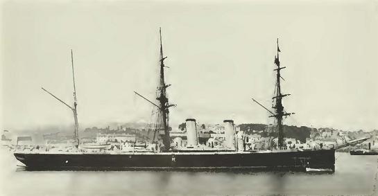

Fig. 20

Fig. 20. H.M.S. Leander. the ship responsible for putting up the barrel which was serving the barrel post office when the expedition of the California Academy of Sciences visited Post Office Bay in 1905.

No. 25] SLEVIN: THE GALAPAGOS ISLANDS 111

Fig. 21

Fig. 21. Envelope addressed to the author and mailed from the Barrel Post Office on Charles Island.


      A member of the Academy's expedition mailed a letter which was afterward found to have been delivered just a year to the day after it was dropped into the barrel. It was picked up by the British yacht Deerhound, finally reaching the office of the Postmaster General in Washington. The rust from the barrel hoops had obliterated the address so that only the surname of the addressee and the city were legible. Nevertheless, the Post Office Department delivered the letter safely.

      A letter to mailed to the writer on January 3, 1932, arrived about a month later, having been picked up by Vincent Astor's yacht Nourmahal. § This was brought to Papeete and came up on the regular mail steamer. Service has improved somewhat in the last few decades.


SHIPWRECKS

      Throughout the years, many vessels have left their bones upon Galápagos shores. When Porter was cruising along the Albemarle coast in search of the enemy, he sighted the wreckage of a vessel within five miles of Point Christopher. The shore was covered with what he took to be barrel staves, which led him to believe the vessel was a whaler, but the surf was too high to attempt a landing and he could not be certain whether the wreck was that of a British or American vessel.

      In later years (1850), the whale ship Lafayette, of New Bedford, was lost on Albemarle, 35 months out with 600 bbls. of sperm oil. She went ashore in the night as the captain was running in to come to

112 CALIFORNIA ACADEMY OF SCIENCES [Oc. Papers

anchor. The vessel was stove in by hitting a rock and became a total loss. The whale ship Golconda, of New Bedford, took off the captain, mate, and part of the crew. Two boats which left the ship were never heard of again.

      The ships Damon, of Newport, the Brandt, of New Bedford, and the bark Catherwood were lost between 1847 and 1855, while the ship President which ran aground was more fortunate than her sisters, reaching home in a damaged condition.

      His Majesty's ship Magicienne had an experience too in touching bottom, which can best be told by her log.

      The Magicienne Rocks, named after the ship, are not shown on the general charts of the islands, but are marked on the detailed anchorage of Gardner Bay on Admiralty Chart No. 1376.

      His [sic - Her] Majesty's steam vessel Magicienne, Nicholas Vansittort [sic - Vansittart] commanding, a wooden ship built in 1847 with tonnage of 1325, was in Gardner Bay, Hood Island, October 14, 1857, where she hit bottom while weighing anchor and narrowly escaped disaster.

October 15, 1857

      7:05 Weighed went on ahead easy set job went on easy proceeding out of Gardner Bay ship took the ground stopped and reversed engine occasionally started 10 tons of water out of boat preparatory to laying out bower anchor transported guns aft lighted two more fires at 8:35 ship floated clear of rock up and in boats and proceeded at 9:05 with two boilers and 8 fires

      Passed Gardner Island steering for the northern part of Charles

      Anchored in Post Office Bay Charles Island ship making 1 1/2 inches of water an hour keep one pump at work during the night


      October 16

      The leak having gained during the night and 10 1/2 in. being in the well worked two pumps and reduced it to 5 in. at 8 a.m.

      Proceed out of the Bay for Indefatigable Isl. under steam with two boilers and made all plain sail

      Anchored in Conway Bay


      October 17

      Ship making water 1 3/4 in. an hour keep one pump at work ship making 1/2 in. an hour with one pump working


      October 18, 1857

      The ship made 7 in. of water in 10 hours, without pumping


      October 19

      Midnight ship making 5/8 in. of water per hour weighed and proceeded out of Conway Bay for Albemarle anchored in the east bay

No. 25] SLEVIN: THE GALAPAGOS ISLANDS 113

      October 20

      Weighed and proceeded out of bay for James Island Anchored at James Bay

      Oct. 21

      Ship making about 5/8 in. of water an hour

      Oct. 22

      At James Bay ship making 1/2 in. water an hour

      Oct. 23

      Proceeded out of James Bay

      Oct. 24

      Passed Bindloe ship under sail


      The ship arrived at Panama October 31, 1857, and was repaired.

      Any seaman can picture the anxious moments the captain spent and the relief it was not to have to report the loss of one of His [sic-Her] Majesty's ships.

      It was only by the greatest fortnne that the schooner Academy, of onr California Academy of Sciences Expedition to the Galápagos Islands, did not leave her bones on the coast of Albemarle, as she hit a reef coming to anchor there. But smooth weather and a sufficient supply of ground tackle saved the day. Sunken reefs and lee shores are not to be trifled with when depending on wind alone for motive power.

      Captain Emil Petersen, of the Norwegian bark Alexandra, had a most unfortunate experience on his visit to the Galápagos. His vessel, bound from Newcastle to Panama, with a cargo of coal was caught in the equatorial calms and lack of provisions, and especially water, caused the captain to yield to the demands of the crew, who had practically mutinied, to abandon ship and take to the boats. On May 8, 1906, the vessel was abandoned and the boats headed for the Galápagos. According to their reckoning, on the third day the mountains of Albemarle were sighted, distant about 25 miles. During the night, however, the currents took them off and next day, the island was lost to view, and it was not until May 20, 1906, that they made Indefatigable, landing in the vicinity of Conway Bay. Unfortunately, this was miles away from the waterhole at Academy Bay, which they did not find until months later. They sustained themselves, however, by drinking the blood of seals they were able to kill and by chewing the pulp of cactus to quench their thirst.

      What a misfortune it was for them that they did not land a few miles to the south, for on May 20, 1906, the day of their landing,

114 CALIFORNIA ACADEMY OF SCIENCES [Oc. Papers

our Academy expedition was becalmed close to the Indefatigable coast five miles south of Nameless Island and probably less than ten miles from the castaways. During their journey in search of water, they reported seeing footprints in a small cove, the remains of a fire, a tin can and some overturned rocks. This must certainly have been one of our former landings as it was customary in places where doves were common, as on this part of the coast of Indefatigable, to bring a frying pan ashore and have fresh meat for lunch, together with a can of fruit to quench our thirst. Also, it was a normal procedure when hunting to turn stones for lizards, insects, and landshells. On this occasion light winds and airs prevented the schooner from making any northing and we drifted down towards Charles Island without catching sight of the castaways.

      Even today the Galápagos Islands have their shipwrecks as the surrounding waters have become the fishing grounds for the American tuna fleet which started sending their vessels there about 1928. Numbered among those which met destruction in the Galápagos area are the clippers St. Veronica, which was wrecked on Albemarle Point, the Radio, which went high and dry on a Narborough beach, the Sun Jacket and the Dominator, both of which sank, and the Glory of the Seas and Southern Cross, which were both destroyed by fire. It behooves the navigator in these waters to be more than cautious, facing both unknown currents, sunken rocks, and reefs just awash.

      It will probably never be known how many ships have left their bones on these inhospitable shores.


EXPEDITIONS TO THE GALAPAGOS

      Before the first organized scientific parties reached the islands, they were visited by four well-known naturalists.

      Hugh Cuming, on the Discoverer, whose cruise to the Galápagos is rather obscure, visited the islands about 1829, some giving the date as 1831-32. Cuming, a born naturalist and ardent collector of shells and plants, was apprenticed to a sailmaker in his youth and learned about ships and sails. Moving to Chile when a young man, he felt the urge to go farther afield on his collecting trips and he built his own vessel, the Discoverer, and was thus enabled to reach the Galápagos. Though in general his expedition cannot be classed as a noteworthy one, it is so to the botanical world, his plant collections having been exhibited a1 the first meeting of the Zoological Society of London in 1832.

No. 25] SLEVIN: THE GALAPAGOS ISLANDS 115

      In 1868, Dr. Simeon Habel left New York bound for the Galápagos, spending approximately six months in the archipelago making large collections of birds, reptiles, insects, and mollusks, which he brought to Vienna to study.

      Dr. Theodor Wolf, in 1875, on board the Ecuadorian vessel Venecia, Captain Petersen, collected plants on Albemarle, Charles, Chatham, and Indefatigable islands, but all of these collections were destroyed while in storage in Guayaquil.

      Next came George Baur who has written extensively on the Galápagos and who was a great believer in the subsidence theory. He spent from June 10, 1891, to September 6 visiting Albemarle, Abingdon, Bindloe, Barrington, Charles, Chatham, Duncan, Hood, Indefatigable, James, Jervis, and Tower islands. Besides collecting in the various branches of natural history, he brought back twenty-one tortoises from Duncan and southern Albemarle.

      The Hudson Bay Company's brig William and Ann, Captain Henry Hanwell, with David Douglas, a famous botanist, and Dr. John Scouler of Glasgow on board, spent three days in January, 1825, on James Island and made the first extensive botanical collection from the Galápagos. Douglas, speaking of his visit, remarked, "The woods teemed with tortoises, some weighing 400 lbs., and the shores with turtle." Of the birds he said: "Many of the smaller kinds perched on my hat, and even unconsciously settled upon the gun (the instrument of their destruction) which I carried on my shoulder."

      The U.S.F.S. Albatross, Lieutenant Commander Z. L. Tanner, was active in Galápagos waters from April 4-16, 1888 and March 28-April 4, 1891. She visited Albemarle, Charles, Chatham. Duncan, Hood, and James. Fifteen tortoises from Albemarle and Duncan islands, besides collections of birds, plants, etc., were taken on the voyage.

      In the late 1880's. Lord Walter Rothschild, of Tring, England, became interested in the giant tortoises of the world and wished to secure the various species found in the Galápagos. To accomplish this, in 1897 the Webster-Harris Expedition was organized, being named after Mr. Frank H. Webster to whom Lord Rothschikl entrusted the organization, and Mr. C. H. Harris who led the expedition in the field. It left San Francisco June 21, 1897, on the schooner Lila and Mattie, Captain Linbridge, and reached the Galápagos on July 25. After a stop of approximately eight months, the expedition returned with sixty living tortoises.

116 CALIFORNIA ACADEMY OF SCIENCES [Oc. Papers

      Though a few of the visiting ships had naturalists on board, the first organized expedition was that conducted by Professor Louis Agassiz, of the Museum of Comparative Zoology at Harvard University, on the United States Coast and Geodetic Survey steamer Hassler, Commander P. C. Johnson, which arrived at Charles Island on June 10, 1873. Besides Professor Agassiz, two other distinguished scientists were on board: Dr. Franz Steindachner of the Royal Zoological Museum at Vienna, Austria, and Count Louis Francois de Pourtales, assistant in the U.S. Coast Survey. The stay of the Hassler was a short one, only nine days, but the following notes of J. Henry Blake, the conchologist and artist of the expedition, give an insight into the many interesting events that occurred while there:


      After passing Hood I. in the night or early morning, which is the most Southern I., we came in sight of Charles I. and anchored in Post Office Bay about 12.15 noon on the 10th of June, 1872.

      As we neared the Island an immense school of porpoises — there must have been one thousand of them, for they extended a great distance on either side of the ship — came toward the ship in a perfect line until within a few hundred feet, then they turned suddenly and went with great speed to the eastward, some of them jumping six feet into the air. The day before this (9th) some fifty black fish (Globicephalus) came up after us, passed under the ship and continued on their course to the N. W. Some half dozen "frigate birds" came off to the ship and attempted to light on our topmasts, but the sharp ends of the lightning conductors which projected above the masts, prevented, when they began to bite at our pennant in a very revengeful manner.

      As we neared Charles I. it showed the characteristic volcanic material of which this and all the islands are wholly composed, which is very black as seen from the ship covered in many places with green vegetation, conspicuous among which is a tall cactus. As we came up with the land and passed around to Post Office Bay, the extinct volcanoes, either in cone shape or sharp peaks and ridges where a part of the cone is broken away, gave the land a very rough appearance.

      As soon as we anchored we went ashore landing on a beautiful beach where we pulled our seine with great success taking some seventeen species of fish. The lines were put over on board ship which were taut almost instantly with fish and large numbers were taken in this way. I collected some twenty species of mollusca besides holothurians, starfish, etc. On the beach we found quantities of red crab which live in holes on the shore. On the rocks was another species of same brilliant color which interested me very much in running over the rocks and actually jumping across from one rock to another, a distance of a foot or more.

      I saw several of the large black lizards (Amblyrhyncus cristatus) which when dry resembles very closely the black volcanic clinkers

No. 25] SLEVIN: THE GALAPAGOS ISLANDS 117

strewn along the shore over which they crawl. There is considerable vegetation in the valleys, a bush 5 or 6 ft. high and some trees 30 or more feet high, and mangrove near the shore. The tall straight cactus is abundant. Birds were plentiful and the smaller ones extremely tame. Some half a dozen lighted on a cactus near where I was sitting and were so tame I put my hand within a few inches of them.

      Our ship's doctor who went with a gun brought back many large birds such as gannets, penguins, frigate birds, flamingos, etc. On one small island at the eastern end of Post Office Bay is a sea lion rookery and where hundreds could be seen at any time. Two of our company went there in our ship's little dingy and found them very plentiful but they surrounded the boat so dangerously near the occupants did not dare to shoot at them for fear of being capsized. Towards evening the Captain with others went in to take a look at them, and landing, on the shore below them, the Captain shot one measuring six or seven feet, as they rushed towards the water into which they plunged, making a noise louder than the waves on the shore. Some of them were of immense size and many could be killed. At night our gill nets were set but only a few sharks were caught.

      The next day I was detained aboard to care for the many specimens already taken. But a fishing party brought back many fish among them a large grouper, some of them weighing 30 lbs. They had also in their boat several pigs and some 8 or 10 tortoises (T. nigra) which they had bought of the natives of the island.

      Some large sea turtles were seen but none were captured. They obtained many specimens of the iguana (A. Cristatus) which attain the length of three feet. At one place visited by the party, were fifty or more of this species. Some 30 or 40 were brought on board, some of which were allowed to run about deck. Two half grown seals were brought on board. There were many birds flying about the ship eating the fish, etc. thrown over. The pelicans attracted the most attention as they filled their large pouches and flew away some so full they could not raise themselves from the water, but dragged their overfilled pouches along its surface. There were seven persons on this Island, and they were short of provisions. They had had no rain for months and had lost many cattle and mules because of it. One of the natives, the Chief, signalled from the shore and our boat brought him aboard our ship where he spent the night. We gave him food and clothing. He said that at one time there were sixty men on the islands which had been leased at $4000 per annum but mutiny and other causes had greatly reduced the number.

      The weather during our stay at the island was delightful. It was somewhat warm on shore during the day, yet not what one would expect at the equator, and the clouds which hung over the island would descend at night hiding the tops of the mountains.

      We weighed anchor on the morning of the 12th and steamed for Albemarle Island, but finding the harbor, Iguana Cove, too insecure and too great a sea on shore for landing, we did not stop, but put our steamer at a slow rate of speed all night intending to reach Tagus Cove in the morning.

118 CALIFORNIA ACADEMY OF SCIENCES [Oc. Papers

      On our way from Charles Island, a large school of blackfish (Globicephalus) came up with us and kept company about half an hour. They were easily seen in the water and at times came within a few feet of the ship's side. I think it was the same species seen off Juan Fernandez, with its prominent white spot near the dorsal fin.

      We also ran into an immense school of porpoises (sharp nosed) which presented a beautiful sight as they started at a rapid rate making a long line of foam and spray.

      The western side of Albemarle as seen from our ship is low with a regular rise to the mountains further back from the coast to the height of 4700 feet. It is covered with vegetation wherever it can find roothold. and supporting moisture. From Iguana Cove to the S. W. part, it is almost a mass of black lava which has come from the mountains above. Some of the lava streams were quite wide, others narrow and some had cooled before they had half reached the base. At the base of the mountain, where this great mass of lava has spread out were innumerable smaller craters of different size. We steamed along the western shore, around Narborough Island and into Tagus Cove, which is almost in the narrows between Albemarle and Narborough, where we anchored about 8.30 A. M. June 13th, 1872.

      We went to the shore and found it no easy matter to land because of the steep landing place. But by backing the boat in, and the men holding it at their oars, we took our chance and jumped for the shore. As we neared the shore we saw many large red crabs and water iguanas (Am. Cristatus) clinging to the bank. These iguanas are black and about three feet long, very disagreeable looking, but could scramble about in a lively manner over the lava.

      They live wholly in or near the salt water where they feed on the algae. I never saw one inland. They even swam off to where our ship was anchored. We had not proceeded far from the shore before we came to the large reddish species of iguana (A. Demarlii) which is seldom met with on the beach. As we went further inland we met many of this species and procured 15 or 20 specimens. They would run in a very clumsy manner and we could easily outrun them. After running awhile they would stop and face us, looking very ferocious but in reality stupid, which gave us a good opportunity to club them. Some times they would jump, standing on their hind legs trying to bite. I made a rough sketch to show color, which is in the possession of the Museum of Comparative Zoology, as well as all specimens, etc. They were yellow on the forward part, the rest of the body to the tip of the tail being a reddish brown excepting a few large brick red patches on the body. The row of spines from the back of the head to the tail corresponded to the color of the body, the longest being on the head. The A. Demarlii is twice as large as the black species (Cristatus) and some will weigh 12 or 15 pounds. It feeds on cactus largely.

      The next day, June 14, the party brought from the shore 15 more specimens of the large iguana.

      We left Tagus Cove and arrived at James Bay, James Island at 11.30 A. M. on the l5th. We landed and made large collections in

No. 25] SLEVIN: THE GALAPAGOS ISLANDS 119

all departments. I collected many shells such as Cypria, Emargenella, Cassidaria, Terebra, Chiton, Doris, etc. Also many radiates. The birds seem especially tame on this island and would almost allow me to touch them with my hand. While collecting on the beach, one bird perched on the rim of my collecting pail by my side and others skipped about me in a very friendly manner. Many large birds were shot including 20 flamingos some of which we had served for the table, but the orange colored tough flesh was not much relished by our mess. Some wild pigs were seen. I noticed three specimens of lizards, one an Amblarynchus Demarlii [sic Amblyrhynchus Demarini] which was not so large as those seen on the other Islands. I found asleep on the shore a turtle several feet long. This island like all the others is wholly volcanic and about the same in vegetation.

      We left James Island about 9.30 A. M. and with a strong head wind, steamed over to Jervis Island anchoring on the north side in 20 fathoms about 3 P. M. With our glass we could see many seals and one large sea turtle on the beach. Boats were lowered and we visited the shore, the first boat capturing the sea turtle which weighed 100 pounds. I was in the second boat and as we neared the shore seals surrounded the boat, while many more were lying about on the land. Directly above, when we landed was an interesting family, a mother and two small seals lying in a shallow excavation which had been made by moving their bodies about, all of whom did not appear to be much disturbed by our presence. (I think Mrs. Agassiz speaks of them in her article in "Atlantic Monthly" for May 1873.) So we seated ourselves about them and studied them as much as we pleased. The mother seal was about six feet long, light gray or silver gray color, the hair being very dry, a rather small characteristic doglike head. The two young seals, were about three feet long and resembled much the old one, excepting the short puppy like noses. I saw other similar families which I did not disturb.

      One large seal I singled out and drove along the beach to study its movements, in its walking or galloping which they did like other four footed animals. It was interesting to see how gracefully they went along the beach and how rapidly they got over the ragged volcanic rocks. The seals were very plentiful lying along the beach or In the water near the shore, also in a small lagoon back from the beach and bones of the dead. We collected considerably in the different departments. I saw a small A. Cristatus and Dr. Steindachner thinks he got a young specimen of the same.

      There was another small species of lizard, Tropidurus which was very numerous, of which we got several dozen. We were told by the inhabitants of Charles Island that there were some 40 people living on this island, but those of the party who went to find them had a fruitless search. Some stakes in the ground near where we landed were the only signs of the inhabitants we saw.

      Leaving Jervis Island about 5 o'clock on the morning of the 17th of June we steamed with very pleasant weather for Indefatigable Island where we arrived about 11 A. M.

120 CALIFORNIA ACADEMY OF SCIENCES [Oc. Papers

      Our stay at this island was shortened by the fact that our provisions were getting reduced, and our collections were not very large. Some new species of fish were taken making our list of fishes taken while at the islands 53 species as determined at the time. We caught many fish from the ship and party sent off "Eden Point" caught many large grouper (Serranus) one of them weighed 23 lbs. After taking all we wanted for specimens and the mess, about 200 lbs. were thrown overboard. I saw none of the large red iguana and none were taken although their holes were seen. A small species with red on the sides of the neck were taken. Saw footprints of man and dog.

      About noon, June 19, 1872, we bade good bye to the Galápagos Islands after a very delightful sojourn of nine days, and shaped our course for Panama. As we steamed away we could see James, Albemarle, Jervis and Indefatigable Islands in sight at one time besides smaller ones two of which were quite interesting because of their shape. The first was a solid mass with flat top, perpendicular sides some 200 feet high, with no small rocks about its base so that the sea was breaking against the steep walls.

      The other. Daphne Island was like an inverted bowl with very symmetrical sides and over the top edge could be seen a portion of the crater. These two small islands were near each other looking lonely enough with not another rock of any kind near.

      As I have said our stay at the Galápagos was too brief to enable one to make a thorough investigation in regard to any particular animal and I am afraid I have given little that is valuable. Although each member of our party had his specialty yet we all tried to improve as much as possible in the limited time spent in the Islands.


      A diligent search was made hy two members of the expedition for the barrel "post office" at Post Office Bay, Charles Island, but it was nowhere to be found and probably had fallen down and weathered away, being replaced when another of His Majesty's ships arrived. The Hassler party also made collections on Indefatigable, James, Jervis, and Albemarle islands.

      In 1898 Messrs. Edmund Heller and Eobert E. Snodgrass, representing the Department of Zoology of Stanford University, sailed oil the sealing schooner Julia E. Whalen, Captain W. P. Noyes, for the Galápagos. They spent from December 10, 1898, to June 26, 1899, visiting all the larger islands and many of the smaller ones, and brought back large herpetological and botanical collections.

      This was the last of the commercial ventures after the Galápagos fur seal, the numbers being so depleted it was no longer considered profitable to hunt them. The net result of this voyage was 224 skins. Since that time, a single one of these fur seals was found bv the

No. 25] SLEVIN: THE GALAPAGOS ISLANDS 121

Fig. 22

Fig. 22. A famous oxpedition vessel was the thirty-one ton schooner Mary Sachs which visited the Galápagos and Revillagigedos, finally leaving her bones on Banks Island in the Arctic Ocean while on the Stefansson Expedition in 1917.


Expedition of the California Academy of Sciences and seven or eight more were taken by Captain Allan Hancock, owner of the Velero III. These last were taken to the San Diego Zoo, giving the first opportunity in recent years to study them thoroughly.

      In 1901 Mr. Rollo H. Beck, who later headed the expedition for the California Academy of Sciences, visited the Galápagos on the schooner Mary Sachs, Captain Linbridge, and was quite successful in his quest for the giant land tortoises. He secured twenty-three dead and twenty-seven living specimens, all of which went to enrich Lord Rothschild's collection in his private museum at Tring. This museum is now an adjunct of the British Museum of Natural History.

      By far the most extensive natural history survey of the Galápagos was that made on the expedition sent out by the California Academy of Sciences. That expedition left San Francisco on June 25, 1905, arriving at Hood Island, the southernmost island of the archipelago, on September 24, 1905. Under the leadership of Mr. Rollo H. Beck, the most intensive collecting was carried on for an entire year, the

122 CALIFORNIA ACADEMY OF SCIENCES [Oc. Papers

Fig. 23

Fig. 23. The schooner Academy made the longest cruise to the Galápagos Islands of any of the expedition vessels. Depending upon the wind for power, she had none of the advantages of the later vessels. She spent a full year in this archipelago, taking her departure from Culpepper, the northernmost of the islands, on September 25, 1906, and arrived in San Francisco on November 29, on the five hundred and nineteeenth day of the voyage.


little schooner Academy bidding- good-bye to the "Enchantcd Islands" on September 25, 1906, taking departure from Culpepper Island at 1:45 p.m. on the 455th day of the voyage. The expedition brought back by far the largest collections of birds, mammals, reptiles, insects, and plants that have ever been taken. The reptile collection included all but one of the fifteen species of giant land tortoises known to inhabit the islands.9 The Norwegian Zoological Expedition to the Galápagos in 1924 was conducted by Alf Wolleback on board the cutter Monsunen. Many papers concerning the various branches of natural history have been published by Meddeleser Fra Zoologiske Museum, Osla [sic - Oslo], and Hakon Nielche, a member of the expedition, gives an account of the voyage and a graphic description of the wreck of the Monsunen on Vanikoro Island, one of the Santa Cruz Islands, in Let's See if the World Is Round.

      The British yacht St. George, in 1924, with James Hornell as scientific director, made extensive collections of birds, mammals, and


      9 Skeletal material of the extinct Charles Island tortoise was received from the late Dr. C. H. Townsend at a later date.

No. 25] SLEVIN: THE GALAPAGOS ISLANDS 123

Fig. 24

Fig. 24. The Oaxaca was one of the several Q boats, or mystery ships as they were sometimes called, built to combat the submarine menace during World War I. Upon cessation of hostilities, she was purchased by Captain Allan Hancock who used her to carry the products of his ranch, which was located near Mazatlan, Mexico, to the markets of the United States. It was on this vessel that he made his first voyage to the Galápagos.


marine life. Four members of the expedition have written of their experiences on the cruise, their works being listed in the selected bibliography.

      No doubt William Beebe's two most interesting and entertaining volumes: Galápagos — World's End, describing the results of his first voyage to the "Enchanted Islands" on the 1923 Harrison Williams Galápagos Expedition aboard the yacht Noma, and Arcturus Adventure, giving an account of his second visit on the Arcturus Oceanographic Expedition in 1925, started a flow of visitors.

      The first of these volumes interested Captain Allan Hancock, of Los Angeles, enough to motivate him to make a trip to the islands in 1928 on his S.S. Oaxaca. Evidently this voyage thoroughly aroused his interest in the "World's End," for in 1931, when his motor vessel Velero III was commissioned, his eyes turned toward the Galápagos once more and he became the host and benefactor to innumerable students from various museums and universities who were eager to follow the steps of Darwin. The years 1931-1935 saw the Velero III in Galápagos waters. Under the name of the Allan Hancock Pacific Expeditions, numerous papers on the results of these voyages have been i)ublished by the University of Southern California.

124 CALIFORNIA ACADEMY OF SCIENCES [Oc. Papers

Fig. 25

Fig. 25. Captain Allan Hancock, on his exploration cruiser Velero III. was host to many institutions and his favorite cruising ground was the Galápagos area. With a cruising radius of 10,000 miles and ideally fitted for research in most any field of endeavor, the Velero III greatly added to our knowledge of the Galápagos fauna.


      The Honorable Gifford Pinchot's voyage on his yacht Mary Pinchot in 1929 resulted in the publication by the United States National Museum of papers on the insects, birds, and fishes taken on the voyage.

      Also, in 1929, the Cornelius Crane Pacific Expedition from the Field Museum of Natural History, Chicago, with Karl P. Schmidt as head of the scientific staff, spent ten days in the islands in January, 1929. This voyage was made on the brigantine Illyria. Mr. Sidney Shurecliffe, a member of the party, gives an account of the Galápagos stop in Jungle Islands — The Illyria in the South Seas.

      The Vincent Astor Expedition of 1930, on the yacht Nourmahal, explored the interior of Indefatigable Island, climbed to an elevation of 1,200 feet, and brought back several of the giant land tortoises.

      William K. Vanderbilt, on his yacht Ara, visited the Islands in 1928. Again in 1931-1932 during his cruise around the world on the yacht Alva, he stopped at the Galápagos. Among the specimens collected on his first voyage was a new species of shark, the band-tailed cat shark (Pristurus arae) which is described in his book To Galápagos on the Ara. The findings of the cruises of the Ara and Alva are published in the Bulletin of the Vanderbilt Marine Museum at Huntingfon, Long Island, New York.

      The Templeton Crocker Expedition of 1932 spent from April 15 to June 16 in the islands making collections of insects, fishes, shells,

No. 25] SLEVIN: THE GALAPAGOS ISLANDS 125

Fig. 26

Fig. 26. Templeton Crocker's yacht Zaca. 118 feet over all. was a strongly constructed two-masted schooner and a deep-sea vessel. Her cruise to the Galápagos was a noteworthy one, both from the standpoint of surveying and that of natural history.


fossils, and birds, the artist Mr. Toshio Asaeda making many water colors of fishes and taking a large series of photographs. The expedition visited thirteen of the islands: Albemarle, Bindloe, Brattle, Charles, Chatham, Duncan, Hood, Indefatigable, James, Jervis, Narborough, South Seymour, and Tower.

      The Philadelphia Academy of Natural Sciences lists two expeditions to the islands: the Dennison Crockett on the yacht Chiva in 1936, and the following year the George Vanderbilt South Pacific Expedition on the yacht Cressida. The Trail of the Money Bird by Dillon Ripley speaks of this voyage.

      An important expedition of late years is the Swedish Deep-Sea Expedition conducted by the noted oceanographer Dr. Hans Petterson on the Swedish motor schooner Albatross in 1947-1948, under the command of Captain N. Kraftt. Swedish scientists having developed a satisfactory apparatus for bringing up core samples from great

126 CALIFORNIA ACADEMY OF SCIENCES [Oc. Papers

ocean depths, visited the Galápagos, taking samples from great depths on the Galápagos plateau. They were the first to accomplish this feat. Besides the oceanographic work, a landing party spent five days on James Island collecting plant life for Professor Carl Skottsberg, Swedish authority on Pacific island flora.

      Sponsored by the Office of Naval Research and Mr. Woodrow G. Krieger, whose yacht Observer was turned over to the expedition. Dr. Bruce W. Halstead, of the School of Tropical and Preventive Medicine at Loma Linda, California, conducted an expedition to Galápagos waters from December 4, 1952, to January 28, 1953 for the purpose of studying the poisonous and venomous fishes found in those waters.


AIR BASE

      Aviation was practically in its infancy when World War I broke out and the air fleets of the time were not considered the hazard they are today. At that time Uncle Sam had only to keep his eye on the Galápagos to see that no enemy occupied them; as a matter of fact, Galápagos waters were not considered a theatre of war in that conflict, though Admiral von Spee, with the German Asiatic Fleet en route to the Falkland Islands, stopped at Villamil to secure fresh meat.

      When the second war broke, however, it was an entirely different matter, the air forces of our enemies being a power that had to be reckoned with at once and with all possible speed. The eyes of the United States were at once focused on the Galápagos as a base from which to patrol the waters adjacent to the Panama Canal, and Ecuador, being informed of the necessity of an air base there, gave permission for its establishment.

      Seymour Island was chosen as the most advantageous site and, being flat and low, did not offer the difficulties that existed on other islands. Also, the prevailing winds being from the southeast and favorable for landings, the planes could come in from the open ocean with no islands of any height to pass over. As soon as the arrangements with the Government of Ecuador were concluded, equipment for the construction of the base was landed with war-time speed, and before long a well-established air base was in operation with quonset huts, machine shops, air strips, and a plant for distilling sea water. As time went on recreation halls and a library were added, and even a newspaper, called The Rock, was in circulation.

      From the Seymour Island base, the Sixth Army Air Force patrolled the waters adjacent lo the Galápagos and the Canal, evidently with

No. 25] SLEVIN: THE GALAPAGOS ISLANDS 127

success as no damage was done to that all important waterway throughout the conflict. On July 15, 1946, the American flag was hauled down and shortly afterwards the base was abandoned.

      The establishment of the Sixth Army Base, however, did not bring the first planes to the Galápagos. These arrived in 1934, when, one William Robinson, on his yacht Svaap, was making a study of the flora and fauna of the islands. Stricken with appendicitis while at anchor in Tagus Cove, the situation became desperate and help had to be found. By good fortune, the tuna clipper Santa Cruz was in the vicinity and contact being made with her, a wireless message was dispatched to Panama for help. The Navy came to the rescue and, as soon as permission was given for the flight, two planes with surgeons on board were on their way to Tagus Cove, followed by the destroyer Hale. The miracle of wireless saved the patient's life and the first flight of planes to the Galápagos was recorded.


TORTOISES

      The gigantic land tortoises from which the archipelago gets its name, were known as "turpin," "termpin," or "terrapin" to the whalers. They are, of course, the most striking objects of the Galápagos fauna. Formerly inhabiting the islands by the thousands, they without doubt made the whaling industry possible in the early days by providing a constant supply of fresh meat, thus preventing scurvy, the scourge of the ancient mariner. As these animals can go for long periods without food or water, the whale ships could stow away great numbers of them between decks and, as far as fresh meat was concerned, there was always a plentiful supply, enabling the vessels to stay at sea for extended cruises. New England whalers having been known to make voyages of two years and more.

      Even though the early buccaneers made use of Galápagos tortoises for food as early as 1684, inroads on the tortoise population really began with the advent of the first whalers in the Pacific in the late 1700's, and from that time on to the late 1850's, the whaling industry caused a tremendous drain on the tortoise population. Besides the actual records of over 13,000 tortoises, mentioned in Dr. Townsend's report on the American Whalers' logs examined,10 an additional thousand are mentioned as being taken by various wlialers and merchant ships whose logs were not examined. Then, too, many British whalers, whose logs were not available, also took a heavy toll. As an example


      10 Zoologica, vol. IV, no. 3, 1925.

128 CALIFORNIA ACADEMY OF SCIENCES [Oc. Papers

of the number of tortoises taken by a single ship, in October 1820, the whaler Essex of Nantucket, in command of Captain George Pollard, took 300 tortoises from Hood Island and 60 from Charles.

      Hunting for fur bearing animals was a common occupation in early times, as it is now, and many hardy mariners came to the shores of the Galápagos in quest of the fur seal. These vessels also took their toll of tortoises.

      George Little was a small boy on the ship Dromo, 600 tons and mounting 26 guns, when he sailed from Boston bound for the Galápagos in quest of fur seals. On May 11, 1807, the ship anchored in Stephens Bay, Chatham Island, and according to his own account which follows, the Dromo took 170 tortoises from the vicinity of the anchorage:


      May 11, 1807: Our five boats were all hoisted out at daylight, and sixty men went on shore with the intention of making two parties, one to take a terrapin, and the other turtle. We succeeded beyond our most sanguin expectations, having taken upwards of twenty fine large turtle, and as many terrapin, some of which were of immense size, weighing from fifty to three hundred pounds. We found considerable difficulty in capturing the terrapin, not only on account of their size, but also from their color, which bore exactly the same appearance as the ground, a dark brown, and which oftentimes eluded the vigilance of the keenest eye. We remained in this place four days [this place refers to Stephens Bay at Chatham Island] during which time we caught 150 turtle and succeeded in getting on board 170 terrapin.

      May 16, 1807: Got under way and stood to sea, our intention being to run to James Island. The wind being light, we did not make it until the 20th, at 9 A. M. Ran close in to leeward, and anchored at 20 fathoms, the shore presenting a fine long sandy beach, on which we landed with our boats without any difficulty.

      James Island is situated in 12' south latitude, and 90° 41' West longitude, and although not so large as Chatham, yet in its soil it is similar in may parts of the island; but on the south side vegetation is more abundant. Here, again, we were doomed to disappointment; no water was to be found after a search of five days; but we caught a few fine turtle and procured a quantity of brushwood. Terrapin was nowhere to be found.

      The terrapin is the best fresh sea stock that can be procured, because they are attended with no expense, and will live for months without food or water. In proof of this, as soon as they were taken, we stowed the greater part of them down in the forepeak and used them as occasion required, the last of which was not killed until about seven months after it was taken, and when prepared for cooking was quite as fat as any of the former.

No. 25] SLEVIN: THE GALAPAGOS ISLANDS 129

Fig. 27

Fig. 27. A typical waterhole scene of 1901 on top of Villamil Mountain, Albemarle Island, the site of probably the largest tortoise colony on the islands until the oil hunters began operations.


      Later, in December 1824, Captain Benjamin Morrell in the sealing schooner Wasp took 100 tortoises off Charles Island.

      During the gold rush days in California when food was somewhat of a problem, trading schooners fitted out for voyages to South America and brought back cargos of onions and potatoes for the California market and, if they were lucky in their venture, tortoises from the Galápagos. With the high prices at the time, potatoes selling at 25 cents a pound and onions at a dollar apiece, many ship owners thought the venture worth while. On January 12, 1850, the schooner Three Hills left San Francisco bound for the Galápagos, thence to go to Porta, Peru, to take on a cargo of potatoes and onions and then to return to the Galápagos for a deckload of tortoises. Besides picking up 225,000 pounds of potatoes and 50,000 pounds of onions at one dollar each, it was planned to take on board 100 tortoises which were to be sold at $50 each. The Three Hills, however, met the fate of many a visitor to the Enchanted Isles. Being caught in a calm and drifting about with the variable currents, she lost most of her potatoes and onions. Instead of 100 tortoises at 50 dollars each, only 20 were secured and sold at $10 each, so instead of making a net profit of $88,125.00 on her cargo as was planned, she suffered a loss of $3,350.00.

130 CALIFORNIA ACADEMY OF SCIENCES [Oc. Papers

      Some five years later, however, on May 13, 1855, a San Francisco paper announced the arrival of the schooner Tarlton with a cargo of 580 tortoises, the largest quantity ever brought in at one time. As late as 1902, the schooner W. S. Phelps, captain Richard Nye, arrived at San Francisco with 37 tortoises which the captain considered the most profitable part of his cargo.

      Oil hunters were another source of destruction and caused the practical extermination of the tortoise population in certain areas, such as Villamil Mountain on southern Albemarle. These hunters systematically killed off the larger tortoises as they contained the most fat. That the remainder survive is due to the fact it no longer paid to hunt them.

      It excited interest just how the whalers hunted these giant creatures and got them on board ship. The following sailor's epistle sent home11 gives a very excellent account and shows that the life of a whaler was no "bed of roses":
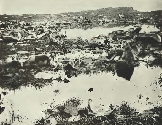

Fig. 28

Fig. 28. Tho oil hunters left this scene of devastation behind them. The largest tortoises containing the most fat were practically exterminated, leaving only the smaller ones which were not worthy of their attention.


      11 Taken from The Friend. a journal devoted to seamen and marine intelligence in general.

No. 25] SLEVIN: THE GALAPAGOS ISLANDS 131

      For three days the crew of our ship had been ashore on Chatham Island and brought back with them two or three boat loads of the most desirable animals which abound on these islands. They always come back nearly exhausted, and their feet and hands were well torn with briars. Clothes which were whole in the morning were rags at night, and new shoes were all gone save possibly a small portion of the upper leather. Hats were shocking bad, and the appearance of all betokened hard service. I should here remark that for four days we had been anchored off Chatham Island, one of the largest of the Gallipagos group. Our ship lay about two miles from a sand beach which had been selected, as affording a good place to land. At 10 A. M. we lowered a boat and pulled ashore. The surf was somewhat heavy, breaking over a reef, but we found the landing very good. Having hauled our boat up alongside the three boats already on shore, our party, consisting of Captain A., Mr. M., 3rd mate, the shipkeeper and self, started, just taking a drink of water from the boat kegs on shore. We had provided ourselves with a few oranges and a small flask of lime juice mixed with water. The path took us immediately into thick bushes, many of which were cotton bushes here growing wild, which, saving in the path, were very thick. Other bushes were covered with long sharp briars and were entwined all around, so that to force your way through them subjected you to having your hands and ankles torn. A small bush bore red berries, which we tasted, but so bitter were they that our mouths were hours recovering their natural taste. The path soon became very rough and was covered with bits of lava, broken and very destructive from the sharp edges to feet and shoes. Ahead of us was a lofty mountain, and on our right hand another, barren and rough in the extreme. The first two miles went off pretty well, Captain A. being naturally a fast traveler, led the way, followed closely by us, Indian file. Mr. M. took with him a tin horn, and as we passed along, would blow a blast, hoping soon to fall in with some of our shipmates on the road to the boats. Presently shouts answered our horn, and the chief and second mates of our ship met us. The former had one large terrapin, the second two of smaller size, slung to their backs. Behind them was Jackson with a still larger one. They cheered us heartily. We stopped a moment and were directed by them which path to pursue, as our path forked just ahead. They looked very much fatigued, and pointed to a still more distant mountain, which they had crossed and found terrapin in abundance. They had with them part of a bottle of water and did not need any assistance. Passing along half a mile toward the mountain we met Jim Hall, a kanaka. Under a cabbage tree lay Jim with a terrapin of large size and small one, a heavy load for the man. The tree afforded him some shade, but he was evidently much exhausted. Mr. M. gave him an orange, which he ate with much satisfaction. The cabbage tree is a curious shrub growing about 15 feet in height. The leaves are like the prickly pear, of oval shape and about one foot in circumference, of light green color. The trunk is, in some cases, as large as a man's body, and when cut appears like a cabbage stalk, the outer bark

132 CALIFORNIA ACADEMY OF SCIENCES [Oc. Papers

like a pitch pine tree. There is much juice in the leaves, and they afford excellent food for the terrapin. As a substitute for water, nothing could by more valuable to this singular animal, for their island home being sometimes for months without rain and no springs of fresh water being found, nature has kindly provided them with this tree, which answers well for food and water. The sun was blazing down upon us, and before we were half way to the ground, I almost regretted having started. Every moment the road grew more rough and the sharp edges of lava made serious inroads into the soles and sides of our shoes. We, in the course of an hour, reached the base of the mountain for which we were steering. Rugged indeed was the side presented to us. It rose very nearly perpendicular to the height of fifteen hundred feet. Huge masses of calcined lava seemed to form its foundation, and no doubt it had been a volcano. But our time would not permit us to ascend its summit. Just here we met two other of our kanakas. They were boys, but each bore his terrapin. One, a very small lad of 12 years, had one of considerable size, and he held it up to our captain with much satisfaction. They had part of a bottle of water with them. On questioning them as to the best on which to find terrapin, they offered to go and show us plenty, but we declined, as they had already brought down a load before. After rounding the base of the mountain, we concluded to divide our party, the "old man," as the master of whale ships is always called, and myself taking the right hand, and Mr. M. and the shipkeeper the left. We were on terrapin ground, and now to find them. We looked among the bushes and rocks, but could see none. Presently we heard Mr. M. shouting: "Town O!", which is a signal when a terrapin is found. We did not join them as they were some distance from us. After looking in vain for some time for the game we were in search of, we travelled on and reached the top of a smaller mountain. Its sides were quite smooth, but covered with bushes. Having descended on the other side, we reached a valley abounding with rough stones, the passage across which was very difficult. Bushes full of thorns we met at every step, and if you took hold of them to keep you from slipping from the stones, your hands would be severely lacerated. The ground now rising, led us to a huge crater more than a mile in circumference, and in depth several hundred feet. It presented a singular and grand spectacle, its vast size, the sides and bottom overgrown with trees and bushes, the rough lava, the awful stillness around, all was grand and sublime. We were amazed as we stood upon the edge of this mighty work of Him whose skill formed the mountain and the seas. Our heads swam as we looked down its awful depth, the reflection striking us. Should we fall, hope would no longer be a virtue. From top to bottom is was a straight line. All around was immense blocks of lava, all black as coal. A short distance from this we came to another crater of smaller size. It was overgrown, as the first mentioned, with trees and bushes, and could not have been burning for many years. It was, if possible, still more rough, and we did

No. 25] SLEVIN: THE GALAPAGOS ISLANDS 133

not dare look at its depth, as the top overhung the opening in part, and one look satisfied us. On the edge of this crater we each ate an orange. Our thirst was very great, but we could not as yet taste our water. No terrapin appeared about, and we concluded to descend into another valley of great extent. Having passed this and ascended a rising, we saw a line of cabbage trees. Under one we saw a very large male terrapin, far above our ability to carry, and on looking a little farther, we found almost under every tree one of the same kind. These huge creatures sat unconcerned, and it was our impression that they had been here for the last five hundred years. When disturbed, they draw in their feet, drop their lower shell on the ground and make a hissing noise not unlike a snake. They do not offer to bite, neither will they run. Some of them were eating cabbage leaves, which had fallen from the trees. Here again how wonderful are the arrangements of Him who provides food, but few facilities for obtaining food, neither being able to climb trees, or to kill other animals, so slow is their motion. Under these trees, which afford them comfortable shade, they rest, watching the fall of a leaf, and when it falls they eat it. If one should not fall for a month, why, he could remain without eating, but from paths leading from tree to tree, no doubt they move from one to another. We now went a little further and found two of about the right size. With two bits of canvas, as straps, we fastened their legs and placed them on our backs, precisely as a soldier does his knapsack, the strings passing under our arms. The weight of each was about fifty to sixty pounds. We, now having secured our prizes, each took a swallow of water. At the first start we found but little difficulty, the path being quite smooth, but soon we came to stones and bushes, and the weight on our backs made us stagger, as we jumped from one rock to another. We lost our way and struck into the thickest range of bushes we had yet met with. It was now three o'clock. The sun blazed down like what — nothing like the sun on the line — our mouths were parched and each step we took only led us from better to worse. Every few minutes we would lose sight of each other in the bushes and have to halloo in order not to get lost. We walked about half a mile and then took off our load and rested — again all ready — sharp stones grew more thick, and we were disheartened at losing the path. We altered our course and hoped of meeting a better one, but none could we find. Again we rested. I wished the terrapin were all in Jerico, for with or without them, we had at least ten miles to travel before we could reach the beach. Here we concluded to eat our last two oranges, and you cannot imagine our disappointment when, on feeling for them, to find that I had lost them from my pocket. It appears a small matter, but I can assure you that their value to us at that time, was very, very great.

      Occasionally we would get a glimpse of the ocean and our ship in the distance, and never did I, in my boyish days, so long to get home as I now did to be safe on board the good craft. Just

134 CALIFORNIA ACADEMY OF SCIENCES [Oc. Papers

now Capt. A. slipped and fell from one rock to another below him, bruising his knee. He recovered himself without any further injury. We could find no traces of a path, and we were about to leave our terrapin behind, but the reflection that all our shipmates would laugh at us, induced us to press on, and if we did fail, to try at least to fall in with some of them and let them see that we had at least tried to do our duty. Here I should remark, that from the time we had landed until we left in our boats to go on board, we had been followed by a host of large flies of a bluish green color, who, without cessation, would light upon our faces and hands and particularly the lips, their bite was sharp, and it was only by constant brushing that we could partially keep them away. I have seen flies before, but never any that would for so many miles follow a traveler. Often we passed the spots in the sand where the terrapin deposits its eggs. They were nicely covered over and there left for the sun to complete the work of incubation. In size they were a little larger than a goose egg. perfectly round, and the shell of same like that of the fowl. How long they remain before hatching I could not ascertain or how long before the animal reaches maturity. We now retraced a part of our steps and struck a path more clear of bushes and clinkers, and found quite a good path. Here we ventured to take another swallow of water. After another hour's travel we met the cooper, our boat steerer, and the steward. So intent were they in pursuit of game, that though we passed within a few feet, they did not notice us until we "sung out" to them. They had been twice to the boats, each time with terrapin, and told us that we had gone in the wrong direction; that they should soon return to the boats, for their terrapin ground was close by. The cooper gave us a draught of water, each of his party having a full bottle with them. We now started in good spirits and soon fell in with the chief mate, who had brought for us a small keg of water at a crossroad, and was waiting for us to come. He kindly offered to take either of our terrapin for us, and we allowed him to take one from us by turns. We had about five miles to travel, and after winding around the base of the mountain first spoken of, the path was excellent in comparison to that which we had passed over. From his water keg I drank freely. Never did water taste so good; lips were parched, tongue dry and swollen. We soon reached the beach, and with some satisfaction laid down our terrapin. They were pronounced good size, and an old sailor patted me on the shoulder and said "Well done". The ensign was flying at the mizzen peak of our ship, and looking out to seaward we saw a small brig standing close to shore. As this was just in the midst of the Mexican War, and privateers might be about, the old man gave orders to launch the boats and go aboard. She proved to be a Columbian schooner who visited these islands to take terrapin oil to the Spanish main. Our boats brought off that day thirty-seven terrapin, which, with those on board, made one hundred and thirty collected

No. 25] SLEVIN: THE GALAPAGOS ISLANDS 135

in four days. Some of these were of large size and were carried by three men, some so small that one man could carry two.

      It is a happy provision of nature that these animals are placed on these islands; they furnish a most excellent recruit for ships cruising in this part of the Pacific Ocean, and when it is remembered that they may be on board for six or nine months without food or water, it will be seen that they are almost invaluable. Aye! says the old man, if we only had these in New York, what a beautiful sum they would fetch — and how well they would fill the bellies of some of the hungry men at Washington — and how for four months have we lived on terrapin soup every other day — morning, noon and night — sea pies made savory with good things — who would not go a whaling. The next morning we weighed anchor and stood along to a settlement about a day's sail from where we took our terrapin, and purchased fifty more of large size. The residents here are about twenty in number, the chief man is named Williams, an Englishman. His colony is composed of Spaniards, and Americans and two slaves. He visited our ship and received trade for his terrapin, cloth, etc., charging us from 50 to 75 cts. each for them. He has two or three hundred of them always on hand for such ships as may call on him. After a delay of a few hours we stood away for another cruising ground.

[Signed]      Camillas     

PRESERVATION OF THE GALAPAGOS FAUNA

      The problem of conserving the Galápagos fauna had been prominent in the minds of naturalists for many years, but it was not until comparatively recently that they became thoroughly alarmed at the conditions which existed. The reptiles most in danger, of course, are the giant tortoises and the iguanas, particularly the land forms. Likewise in great danger are many species of birds, particularly the cormorants, penguins, flamingos, and doves. It was not until such men as Robert Moore of The American Committee for International Wild Life; Dr. John C. Merriam, President of the Carnegie Institution of Washington; Mr. H. W. Parker of the British Museum of Natural History, London, England; Mr. Harry S. Swarth of the California Academy of Sciences; and many others too numerous to mention started an active campaign that the wheels were set in motion and the Government of Ecuador was contacted. After several months of study, a plan was submitted, and with some modifications approved, and His Excellency, President Abelardo Montalvo, published the decree known as "Poder Ejecutive No. 807, Parte Tercera." This, in short, names the birds, animals, and reptiles that are strictly protected, names the islands that are set aside as game preserves, and declares that all vessels visiting the Galápagos must call first at Chat-

136 CALIFORNIA ACADEMY OF SCIENCES [Oc. Papers

Fig 29.

Fig. 29. Monument erected at Wreck Bay, Chatham Island, the first of the Galápagos Islands on which Darwin landed during the memorable voyage of the Beagle.

No. 25] SLEVIN: THE GALAPAGOS ISLANDS 137

ham Island, the seat of the government. The American Committee for International Wild Life Protection issued a circular for the benefit of American yachtsmen calling attention to the Ecuadorian laws and also to the U. S. Tariff Act of 1930 and Customs Order T. D. 48173, of February 20, 1936, which makes it mandatory to confiscate all Galápagos fauna, alive or dead, taken contrary to Ecuadorian law.

      Mr. Wolfgang von Hagen, naturalist and explorer who has written much concerning the Galápagos, was another one who became intensively interested in the preservation of the fauna and entertained the idea of paying tribute to Darwin on the one-hundredth anniversary of his landing on the islands. To this end, he enlisted the help of the British Association for the Advancement of Science, the Linnean Society of London, and the American Museum of Natural History, the last organization supplying a mold from which was cast the bronze bust placed on the pedestal at Wreck Bay, Chatham Island, the island on which Darwin first landed.

      The following inscription, written by the late Major Leonard Darwin, at that time Darwin's only surviving son, was placed thereon:

CHARLES DARWIN

Landed on the Galápagos Islands in 1835 and his studies of the distribution of ariimals and phmts thereon led him for the first time to consider the problem of organic evolution. Thus was started the revolution in thought on this subject which has since taken place

Erected in 1935

      Also, to commemorate this momentous occasion, the Government of Ecuador issued a set of six stamps with appropriate designs, the one sucre having a portrait of Columbus, for whom the islands were named, the two sucre shows an island coastal scene, the 2, 5, 10, and 20 centavos a map of the islands, an iguana, a tortoise, and the head of Darwin respectively.

      Darwin states in his diary that on September 17, 1835, he landed on Chatham Island and although the monument marking his landing is at Wreck Bay, he apparently set foot ashore at Stephens Bay, according to the log of H.M.S. Beagle, as shown by the following entries:

A. M. Wednesday 16th September 1835

      5 — Saw Woods (Hood) Isld to Stbd — tacked

138 CALIFORNIA ACADEMY OF SCIENCES [Oc. Papers

Fig. 30

Fig. 30. Plaque of monument erected in honor of Charles Darwin at Wreck Bay, Chatham Island.


P. M.  at 1.40 Hove to, sounded — made sail
           at 2.10 trimmed
           at 3.10 rounded to for soundings — made sail again standing
           for the S. W. end of Chatham Island at 4.15 shortened sail
           and came to with Best Bower under the north west end of
           Chatham Island veered to 40 fms and furled sails
           Thursday 17th Septemher 1835

No. 25] SLEVIN: THE GALAPAGOS ISLANDS 139

Fig. 31

Fig. 31. The Albatross II. practically a sea-going tug, was loaned by the United States Fish and Game Commission for a voyage to the Galápagos for the purpose of bringing back enough tortoises for breeding purposes in order to save the race from extinction.


A. M
           at 8.35 weighed trimmed and made sail as requisite standing
           along the north side of Chatham Island at 11 shortened sail
           and came to in Stephens Bay in 12 fms at anchor in Stephens Bay"


      A noted conservationist, the late Dr. C. H. Townsend, formerly with the U. S. Bureau of Fisheries, made a voyage to the Galápagos in 1928 under the auspices of the New York Zoological Society on board the U.S.F.S. Albatross II, Captain G. A. Carlson commanding. the vessel was loaned by the Bureau of Fisheries for the voyage, the express purpose of which was to gather a number of tortoises for breeding and spot them in favorable localities in hopes that they would reproduce, thereby helping to preserve the race in case those in their native habitat should not be able to withstand the ravages of their enemies. The voyage was a decided success, one hundred and eighty tortoises being secured. These have been scattered in colonies in Florida, Louisiana, Texas, Arizona, California, Bermuda, Hawaii, and Australia. Whether the scheme is a success still remains to be seen, but it is at least an effort to help preserve these grotesque creatures from extermination.

      It is hoped by naturalists the world over that this remarkable Galápagos fauna may be preserved for those who may follow and walk in the footsteps of Charles Darwin, whose voyage on the Beagle made these "Enchanted Isles" immortal.

140 CALIFORNIA ACADEMY OF SCIENCES [Oc. Papers

SELECTED BIBLIOGRAPHY

Agassiz, Alexander

1892. General sketch of the expedition of the Albatross from February to May 1891. The Galápagos Islands. Bulletin of the Museum of Comparative Zoology, 23(1): 56-74.

Agassiz. Elizabeth C.

1873. A cruise through the Galápagos. Atlantic Monthly, May 1873, pp. 579-584.

Allan, R. C.

1836. Remarks on some of the Galápagos Islands. Nautical Magazine, 5:66-68.

Anderson, Charles R.

1902. The White Whales Wake Melville in the South Seas. New York. 522 pp.

Anonymous

1936. The Galápagos as they were in 1817. Illustrated London News, 98(2556): 687-689.

1957. To save the Galápagos. Zoo, 2(1): 14-17.

Banning. George H.

1933. Hancock Expedition of 1933 to the Galápagos Islands. Bulletin of the Zoological Society of San Diego, no. 10. May 1933, 30 pp.

Barker. G. N.

1938. Third Presidential Cruise of the U.S.S. Houston, printed on board U.S.S. Houston, 1938, 75 pp.

Barlow, Nora

1932. Robert Fitz-Roy and Charles Darwin. Cornhill Magazine, April 1932, pp. 493-510.

1934. Charles Darwin's Diary of the Voyage of H.M.S. Beagle, edited from the manuscript. Cambridge, 1934, 451 pp.

Barrow, John

1836. Sketch of the surveying voyages of His Majesty's ships Adventure and Beagle, 1825-1836. Commanded by Captain P. P. King, P. Stokes, and Fitz-Roy, Royal Navy. Communicated by Sir John Barrow. Journal of the Royal Geographical Society of London, 6: pp. 311-343.

Baur, George

1889. The gigantic land tortoises of the Galápagos Islands. American Naturalist, 23:1039-1057.

1891. Comments on the distribution of birds and reptiles on the Galdpagos Islands. American Naturalist, 25:902-907.

No. 25] SLEVIN: THE GALAPAGOS ISLANDS 141

Baur. George — Cont'd

1892. Professor A. Agassiz on the origin and flora of the Galdpagos Islands. Science, 19(477):47.

1893. The differentiation of species on the Galdpagos Islands and the origin of the group. In Biological Lectures, Marine Biological Laboratory, Woods Hole, Massachusetts, 1893, pp. 67-68.

Beaglehole, J. C.

1934. Exploration of the Pacific. London. 410 pp.

Beck, R. H.

1903. In the home of the giant tortoise. Seventh Annual Report of the New York Zoological Society (Reprint), New York, April 1, 1903, pp. 1-17.

1904. Bird life among the Galápagos Islands. Condor, 6(1):5-11.

Beebe, William

1923. Five hours in Galápagos. Bulletin of the New York, Zoological Society. 27(1): 19-26.

1923. Galápagos reptiles and birds in the Zoological Park. Bulletin of the New York Zoological Society, 26(5): 99-106.

1923. Galápagos, Isles of the tortoises. Asia, 23:809-815.

1923. Williams Galápagos Expedition. Zoologica, 5(1): 3-20.

1924. Galápagos: World's End. New York and London, 443 pp.

1924. Strangest islands in the seven seas. Travel, 23:33-37.

1925. Adventures in exploration at the World's End. Mentor, 13:1-19.

1925. Logging the Arcturus, a visit to the Galápagos. Bulletin of the New York Zoological Society, no. 4, July, 1925, pp. 103-116.

1926. The Arcturus Adventure. New York, 1925, 439 pp.

1926. Birth of a volcano; how Galápagos World's End became World's Beginning. World Today, 47:243-257.

1926. Birth of a volcano. Ladies Home Journal, 32:237-242.

1926. The Arcturus Oceanographic Expedition. Zoologica, 8:1-45.

1928. A volcanic aftermath (Galápagos Islands). Bulletin of the New York Zoological Society, 31(4): 111-113.

1937. Turtle sanctuary, Harper's Monthly Magazine, November, 1937, pp. 653-660.

1937 A week in paradise. Harper's Monthly Magazine, October, 1937, pp. 521-529.

Beebe, William, and Ruth Rose

1925. Second half of Arcturus adventure experiences in the Galápagos Islands. Bulletin of the New York Zoological Society, 28:119-129.

Benchley, Belle J.

1938. Treasure trove. Zoonooz, March, 1938, pp. 1-7.

142 CALIFORNIA ACADEMY OF SCIENCES [Oc. Papers

Blomberg, Rolf

1951. Strange reptiles of the Galdpagos. Natural History, 60(5): 234-239.

Boettger, O.

1895. Referet uber "Baur's differentiation of species on the Galápagos Islands etc.," Zoologischer Centralblatt, 2:461-463.

Bognoly, Jose A. and Jose M. Espinosa

1917. Las Islas Encandos O'el Archipielago de Colon. Guayaquil, 1917, 210 pp.

Breder, C. M., Jr.

1925. A relative of the Galápagos tortoise. Origin of the giant tortoises in Galápagos Islands. Bulletin of the New York Zoological Society, 28(3): 64-65.

British Foreign Office

1920. Handbooks prepared under the direction of the Historical Section of the Foreign Office, nos. 140-143, London, 1920, pp. 1-37.

Brown, Barnum

1931. The largest known land tortoise. Natural History, 31(2):183-187.

Burney, James

1816. A Chronological History of the Voyages and Discoveries in the South Sea or Pacific Ocean to the Year 1723 Including a History of the Buccaneers of America. Vol. 4, London, 1816, 580 pp.

Byron, Lord

1826. Voyage of the H.M.S. Blonde to the Sandwich Islands in the Years 1824-1825. London, 260 pp.

Calman, W. T.

1936. Centenary of Darwin's visit to the Galdpagos Islands. Nature, 138 (3479):15-16.

Cary, Byron

1834. Note on a large specimen of the Galápagos tortoise. Proceedings of the Zoological Society of London, 1834, p. 113.

Chapin, James P.

1936. islands of the west coast of south america — further e.xplorations on the schooner zaca to selkirk's juan fernandez, the rainless guano islands of peru, and exotic Galápagos. Journal of the American Museum of Natural History, 37:31-38.

Chubb, Lawrence John

1933. Geology of Galápagos, Cocos, and Easter islands with petrology of Galdpagos Islands by Constance Richardson, Bernice P. Bishop Museum Bulletin. 110:1-67.

No. 25] SLEVIN: THE GALAPAGOS ISLANDS 143

Clark, Hubert Lyman

1917. Reports of the scientific results of the Alhatross in charge of A. Agassiz by the U. S. Fish Commission from 1904 to March 1905. Bulletin of the Museum of Comparative Zoology, 61(12).

Clover, Sam T.

1932. A pioneer heritage. Los Angeles, 1932. Pp. 140-162 and 182-240.

Cochran, D. M.

192S. Turtles of the Galápagos. Nature Magazine, 12:322-324.

Collenette, C. L.

1925. Sea-Girt Jungles — The Experience of a Naturalist with the St. George Expedition. London. Pp. 72-116.

Colnett, J,

1798. Voyage to the South Atlantic and Round Cape Horn into the Pacific Ocean, for the Purpose of Extending the Spermaceti Whale Fisheries. London, 179 pp.

Conway, Ainsle, and Frances Conway

1947. The Enchanted Islands. New York, 280 pp.

Cooke, Edward

1712. Voyage to the South Sea and Round the World. Performed in the years 1708, 1709, 1710, 1711, by the ships Duke and Duchess. London, pp. 144-150.

Dalrymple, Alexander

1770. A Historical Collection of the Several Voyages and Discoveries in the South Pacific Ocean. Vol. 2, London, pp. 122-124.

Dampier, William

1679. A New Voyage Around the World. London.

Darbyshire, M. B.

1936. Aboard the Velero III. Country Life, 70:31-36.

Darwin, Charles

1952. Journal of Researches into the Geology and Natural History of the Various Countries visited by H.M.S. Beagle (A facsimile reprint of the first edition, 1839). New York-London. 1952, 6239 pp.

Delano, Amasa

1817. A Narrative of Voyages and Travels in the Northern and Southern Hemispheres Comprising Three Voyages Around the World Together with a Voyage of Survey and Discovery in the Pacific Ocean and Oriental Islands. Boston, pp. 369-385.

Dodd. Enw. H., Jr.

1930. Great Dipper to Southern Cross. New York, pp. 78-113. [An account of the cruise of the schooner Chance.]

144 CALIFORNIA ACADEMY OF SCIENCES [Oc. Papers

Douglas, A. J. A., and P. H. Johnson

1926. The South Seas of Today — An account of the cruise of the yacht St. George to the South Pacific. London, pp. 56-72.

Du Petit Thouars, Abel

1846. Voyage Autour de Monde sur la Frigate La Venus Pendant les Annees 1836-1839. Paris.

Eardley-Wilmot, S.

1873. Our Journal in the Pacific by the Officers of H.M.S. Zealous. Arranged and edited by Lieutenant S. Eardley-Wilmot, London, 333 pp.

Eisajian, Josiah R.

1952. Operation "Clinkers." Carnegie Magazine, Feb. 1952, pp. 42-45 and 58, and 82-85 and 101.

Espada, Marcos Jiminez de la

1892. Las Islas de Los Galápagos y Otras Mas a Poniente. Sociedad Geographica de Madrid, 51 pp.

Fahnestock, Bruce, and Sheridan

1938. Stars to Windward. New York, 295 pp.

Fortesque, Granville

1911. The Galápagos Islands. Bulletin of the Pan American Union, February, 1911, pp. 222-239.

Garman, Samuel

1917. The Galápagos Tortoises. Memoirs of the Museum of Comparative Zoology, 30(4): 261-296.

Garth, John S.

1936. Galdpagos. Pacific Geographic Magazine, 1 {2): 20-25,40.

Gerrault, Alain

1930. In Quest of the Sun. New York, 303 pp.

Gormaz, Francisco Vidal

1890. Capitan de Navio de la Armada Nacional Las Islas de Los Galápagos y Otras Mas a Poniente. Del Anuario hidrografica, tomo 15, 47 pp.

Grant, Madison

1928. Conservation of wild life. Bulletin of the New York Zoological Society, 31(5): 147-148.

Gunther, Albert

1877. Account of the zoological collection made during the visit of H.M.S. Peterel to the Galápagos Islands. Proceedings of the Zoological Society of London, 1877, pp. 64-91.

No. 25] SLEVIN: THE GALAPAGOS ISLANDS 145

Hamilton, Frederick

1903. Hunting the giant tortoise. Wide World Magazine, 11:25-30.

Harritz, Alf

1915. Mandskapet fra Bark Alexandra. Kristiana, 1915.

Heller, Edmund

1903. Papers from the Hopkins-Stanford Galápagos Expedition, No. 14, Reptiles. Proceedings of the Washington Academy of Science, 5:48-59.

Heyerdahl, Thor

1953. American Indians in the Pacific. New York, pp. 449, 548, 549, 561-568, 573, 597, 606, 617, and 618.

Hicks, J. B.

1927. Nature notes on the Galápagos Islands. Discovery, 8:112-114.

Hobbs, William Herbert

1945. The Fortress Islands of the Pacific. Michigan, pp. 9, 26, 64, 65, 160, 161.

Hodges, G. C.

1917. Galápagos Islands — Pacific's Key to Panama. Sunset, 39:36-37.

Holder, Charles F.

1901. The turtles of the Galápagos. Scientific American, 85(9): 139—140.

Howard, Sydney

1934. Isles of Escape, being the Adventures of Roydon Bristow. London, pp. 45-208.

Howell, John Thomas

1941. Hugh Cuming's visit to the Galápagos Islands. Lloydia, 4(4): 291-292.

1942. Up under the equator. Sierra Cluh Bulletin, 27(4): 79-82.

Johnson, Irving, and Elixta Johnson

1942. Westward Bound in the Yankee. National Geographic Magazine, 81:1-44.

1949. The Yankee's wanderland. National Geographic Magazine, 95:1-50.

Korwin, H.

1931. Galápagos Islands, or Colon Archipelago. Bulletin of the Pan American Union, 65:1140-1144.

Kroeber, A. L.

1916. Floral relations among the Galápagos Islands. University of California Publications in Botany. 6(9):199-220.

Lack, David

1940. Evolution of the Galápagos finches. Nature. 146(3697):324-327.

1945. The Galápagos Finches (Geospezinae). Occasional Papers of the California Academy of Sciences, no. 21, 158 pp.

1947. Darwin's Finches. Cambridge, 218 pp.

146 CALIFORNIA ACADEMY OF SCIENCES [Oc. Papers

Lanier, R. J.

1932. The Templeton Crocker Expedition. (To the Revillagigedo, Galápagos, and Tres Marias Islands). Aquarium Journal, 5(8): 44-45.

Little, George

1845. Life on the Ocean or Twenty Years at Sea being the Personal Adventures of the Author. Boston, pp. 65-71.

Lowe, P. R.

1934. On the need for the preservation of the Galápagos fauna. Birds. Proceedings of the Linnaean Society of London, Session 146. pp. 84-89.

Lucas, Frederick A.

1922. Historic tortoises and other aged animals. Natural History. 22(4): 301-305.

Mann, Alexander

1909. Yachting on the Pacific. London, 1909, pp. 7-75.

Mazet, Rohert, Jr.

1938. Fisherman's Paradise — Settler's Hell. U. S. Naval Institute Proceedings, 64(423): 717-732.

Melville, Herman

1940. The Encantadas or, Enchanted Isles with an Introduction, Critical Epilogue and Biographical Notes by Victor Wolfgang von Hagen. San Francisco, 118 pp.

Meredith, De Witt

1939. Voyages of the Velero III. Compiled by De Witt Meredith for Captain George Allan Hancock, Los Angeles, 286 pp. (pictorial version).

Mielche, Hakon

1938. Let's See if the World is Round. London, 330 pp.

Mindte, Richard W.

1942. The Galápagos: Pacific Guardians of the Panama Canal. U. S. Naval Institute Proceedings, 68(471): 651-654.

Moore, R. T.

1935. The protection and conservation of the zoological life of the Galapa gos Archipelago. Science, 82(2135):519-521.

Morrell, Benjamin

1832. A Narrative of Four Voyages to the South Sea and Pacific Ocean. New York.

Murphy, Robdrt C.

1939. Men of war. Natural History. 44(3):133-143.

No. 25] SLEVIN: THE GALAPAGOS ISLANDS 147

Orr, Robert T.

1942. Darwin's finches. Bulletin of the New York Zoological Society, 45(6): 142-145.

Parker, H. W.

1934. On the need for the preservation of the Galápagos fauna. Reptiles. Proceedings of the Linnaean Society of London, Session 146, pp. 80-84.

Perkins, C. B.

1942. Iguanas. Zoonooz, San Diego, July, 1942, pp. 3 and 5.

Peters, Harold

1937. The pilgrim sails the seven seas. National Geographic Magazine, 72:223-224.

Piccone, Antonio

1889. Nuove Alghe de Viaggio di circumnaviga-zione della Vettor Pisani. Memorie Classe di scienze fisiche, mathematiche e naturali Academia dei Lineei, ser. 4, 6:10-63.

Pinchot, Gifford

1930. To the South Seas, the Cruise of the Mary Pinchot to the Galápagos, The Marquesas, and the Taumoto Islands, and Tahiti. Philadelphia, pp. 98-281.

Porter, David

1815. Journal of A Cruise made to the Pacific Ocean by Captain David Porter in the United States Frigate Essex in the years 1812, 1813, 1814. 2 vols., Philadelphia. Second edition. New York. 1822.

Reynolds, George H.

1936. Tales of Whalers — Galápagos Tortoises vs. Salt Horse. New Bedford.

Reynolds, T. N.

1835. Voyage of the United States Frigate Potomac under the command of Commodore John Downes during the Circumnavigation of the Globe in the years 1831, 1832, 1833, and 1834. New York, 560 pp.

Ribadeneira, Jorge A.

1942. El Volcan Grande en la Isla Isabela (Galápagos). Flora Epoca, 2:113-114.

Ridgeway, Robert

1897. Birds of the Galápagos Islands. Proceedings of the United States National Museum. 19:450-670.

Ritter, Friedrech

1931. Eve calls it a day. Atlantic Monthly. 148:733-743.

1931. Adam and Eve in the Galápagos. Atlantic Monthly. 148:409-418.

1935. Satan walks in the garden. Atlantic Monthly. 148:565-575.

148 CALIFORNIA ACADEMY OF SCIENCES [Oc. Papers

Robinson, William Albert

1936. Voyage to Galápagos. New York, 279 pp.

Rogers, Woodes

1717. A Cruising Voyage Around the World — First to the South Seas, thence to the East-Indies, and Home. Begun in 1708 and Finished in 1711. London, 1717, 428 pp.

Rose, Ruth

1924. Pets and super-pets on Galápagos Island. Bulletin of the New York Zoological Society, 27(1): 27-31.

Rothschild, Walter, and Chas. M. Harris

1897. The discovery of the flightless cormorant. Bulletin of the New York Zoological Society, 28(1):12.

Scammon, Charles M.

1869. On the cetaceans of the western coast of North America. Proceedings of the Philadelphia Academy of Sciences, 21:60.

1874. The Marine Mammals of the Northwestern Coast of America Described and Illustrated; Together with an Account of the American Whale-fishery. San Francisco, 1874, 319 pp.

Schmidt, Karl P.

1935. Breeding behavior of the marine iguana. Zoological Series Field Museum of Natural History, 20(9): 71-74.

Seemann, Berthold

1853. Narrative of the Voyage of H.M.S. Herald During the Years 1845- 1851 Under Command of Captain Henry Kellett. R.N.. Being a Circumnavigation of the Globe and Three Cruises to the Arctic Region in Search of Sir John Franklin. Two vols. London.

Shurcliff, Sydney N.

1930. Jungle Islands — The Illyria in the South Seas. New York, pp. 71-105. Contains Essay on the Zoogeography of the Pacific Islands by Karl P. Schmidt, pp. 280-285.

Shillibear[sic-Shillibeer], John

1817. A Narrative of the Briton's Voyage to Pitcairn's Island. London. pp. 29-32.

Slevin, Joseph R.

193L Log of the schooner Academy, on a voyage of scientific research to the Galápagos Islands, 1905-1906. Occasional Papers of the California Academy of Sciences, no. 17, 162 pp.

1935. An account of the reptiles inhabiting the Galápagos Islands. Bulletin of the New York Zoological Society. Vol. 38, no. 1, New York. Jan.-Feb., 1935, pp. 2-24.

No. 25] SLEVIN: THE GALAPAGOS ISLANDS 149

Slevin, Joseph R. — Cont'd

1935. An Equatorial Wonderland — -the Galdpagos, a country of great volcanoes, giant tortoises, and flightless birds. Natural History, 36:375-378.

1936. Tame "wildfowl" of the Galápagos Islands: an archipelago where the unique avifauna lives unmolested by man. Illustrated London News, 188(5065): 873-875.

1937. John Marshall Gamble. Paradise of the Pacific, 49(7):26.

1940. "Lost grave" of Cowan on Galápagos. Paradise of the Pacific, 52(6): 25-26.

1950. Post office in a barrel. Pacific Discovery, 3(2): 28-29. March-April.

1955. Charting the "Enchanted Isles." In: Essays in the Natural Sciences in honor of Captain Allan Hancock. University of Southern California Press, pp. 99-110, 4 maps.

Solis, M. Acosta

1937. Galápagos observade fito logicamente. Imprenta de la Universidad Central, Quito, 1937, pp. 78.

Stackpole, Edouard

1953. The Sea Hunters — the Great Age of Whaling. Philadelphia, 510 pp.

Strauch, Dore

1936. Satan Came to Eden. New York and London, 1936, 274 pp.

Strout, Edith Baur

1939. At home on the oceans. National Geographic Magazine, 76:33-86.

Svenson, Henry K.

1935. Plants of the Astor Expedition 1930 (Galápagos and Cocos Islands). American Journal of Botany, 22:208-277.

1946. Vegetation of the coast of Ecuador and Peru and its relation to the Galápagos Islands. Brooklyn Botanic Garden, Contribution 104, pp. 394-498.

Swarth, Harry S.

1931. The avifauna of the Galápagos Islands. Occasional Papers of the California Academy of Sciences, no. 18, 299 pp.

1934. The bird fauna of the Galápagos Islands in relation to species formation. Biological Reviews, 9(2):213-234.

Taber, C. A. M.

1891. Origin of the Galápagos rookeries. Science, 17:290.

Tarnmoor, Salvator R.

1854. The Encantadas or Enchanted Isles. Putnam's Monthly Magazine, 3:311-319.

Tee-Van, John

1923. Capturing a giant tortoise on the Galápagos Islands. Bulletin of the New York Zoological Society. 26(5):123-128

150 CALIFORNIA ACADEMY OF SCIENCES [Oc. Papers

Townsend, C. H.

1924. Impending extinction of the Galápagos tortoises. Bulletin of the New York Zoological Society, 27(2): 55-56.

1925a. Whaler and tortoise. Scientific Monthly, 21:166-172.

1925b. The Galápagos tortoises in their relation to the whaling industry. Zoologica. 4(3): 55-135.

1928. The Galápagos Islands revisited. Bulletin of the New York Zoological Society. 31(5): 148-169.

1930. The Astor Expedition of Galápagos Islands. Bulletin of the New York Zoological Society. 33 (4):135-173.

1931. Giant tortoises nearing extinction are being propagated in the United States. Scientific American, 144:42-44.

1934. The fur seal of the Galápagos Islands. Zoologica, 18(2): 47-49.

Tucker, Gilbert N.

1943. The career of H.M.C.S. Rainbow. British Columbia Historical Quarterly, 7(1): 24.

Van Dvke, Edwin C.

1953. The Coleoptera of the Galápagos Islands. Occasional Papers of the California Academy of Sciences, no. 22, 181 pp.

Vanderbilt, William K.

1927. To Galápagos on the Ara. New York, 161 pp.

Vinton, K. W.

1951. Origin of life on the Galápagos Islands. American Journal of Science, 249(5): 356-376.

von Hagen, Victor Wolfgang

1937. Centenarians of the Galápagos. Travel, 49(1): 32-33 and 46.

1940. Ecuador the Unknown. New York, 296 pp.

1937a. The flamingoes of the Galápagos Islands. Natural History, 39: 136-139.

1937b. Galápagos land iguanas. Nature. 29(6):368-370.

1937c. Sea iguanas of the Galápagos. Nature, 29(3):147-149.

1949. Ecuador and the Galápagos Islands. University of Oklahoma Press. 290 pp.

von Hagen, Victor Wolfgang, and Q. Hawkins

1940. Treasure of the Tortoise Islands. New York, 202 pp.

Wafer, Lionel

1699. A New Voyage and Description of the Isthmus of America. Reprint from original. Edited by George Parker Winship, Cleveland, 1903, 212 pp.

Wallace, Alfred

1876. The Geographical Distribution of Animals. London, Vol. 2, 607 pp.

Wintour, C. J.

1900. The strange hunt of the wild hound. Wide World Magazine, 5(26): 200-203.

Wolf, Teodoro

1892. Geografia Y Geologia del Ecuador Publicada por orden del Supremo Gobierno de la Republica Leipsig, 1892, Parte V. El Archipelago de Galápagos, pp. 469-493.

Notes.

      Joseph Richard Slevin (September 13, 1881 – February 17, 1957) was an American herpetologist and the second curator of herpetology at the California Academy of Sciences, with which he was affiliated for over 50 years. He collected reptile and amphibian specimens from around the world, notably in the Galápagos Islands in a 17-month expedition, and was largely responsible for re-growing the Academy's herpetological collection following its destruction in the 1906 San Francisco earthquake. He wrote or co-wrote nearly 60 scientific papers, and is commemorated in the scientific names of over a dozen species or subspecies of animals and plants. [Wikipedia.]

Source.
Joseph Richard Slevin.
      The Galapagos Islands: A History of Their Exploration.
Occasional Paper no. 25 California Academy of Sciences
    San Francisco: Academy of Sciences, 1959.

This transcription was made from a publication in the collection of the Biodiversity Heritage Library.


Last updated by Tom Tyler, Denver, CO, USA, December 28, 2024.

Previous Galapagos IslandsContentsNotesSourceWhalesite Next