


The Lenox Globe
Benjamin Franklin de Costa
* & † Footnotes in original document.
§ Footnotes added to this online page.
Dashed line on Lenox Globe image also added.
The Lenox Globe was found in Paris about twenty-five years ago [ca. 1854] by Mr. Richard M. Hunt, who presented it to Mr. James Lenox, the munificent founder of the institution which bears his name, the gift forming a graceful and appropriate recognition of the interest taken by Mr. Lenox in everything that relates to the history of America.
The Lenox Globe is the smallest of the ancient globes, being only about five inches in diameter, though this is half an inch more than the diameter of the prize globe of the Paris Exposition. The Lenox Globe is of copper and the workmanship is good, it being constructed in two sections, fitting together like a box, as in the case of the Vulpius Globe, the joint forming the Equatorial line. The degrees of latitude and longitude are not indicated, but on the sketch, of the size of the original, a scale is added [of latitude only, at left]. The date and the maker's name are both wanting, but there can, perhaps, be little doubt respecting its age, which, for various reasons, may be placed at the year 1510, or the beginning of 1511.
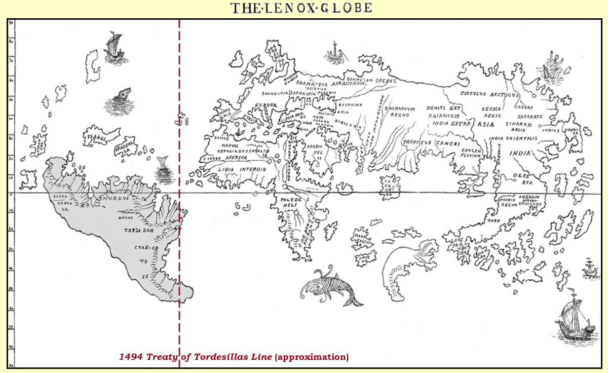
§ See text and footnote below for a possible explanation of the shape of southern tip of South America.
It will be observed that the eastern hemisphere occupies a disproportionate part of the longitudinal surface; yet on the other hand, many of the principal latitudes appear tolerably correct for the period in which the globe was made. The mountings of the globe are lost.
The date of 1510-11 has been assigned, for the reason, amongst others, that, while several of its representations are in advance of the published knowledge of 1508, they are behind that of 1511-12. Of course the simple fact that an instrument of this kind represents the condition of geographical knowledge at a certain period does not infallibly prove that it was produced at that particular period. Under peculiar circumstances, it would be possible for an instrument like this to possess many of the marks which indicate an early origin, simply through the failure of the projector to incorporate the results of the latest explorations, concerning which he might have been ignorant; but this suggestion, in order to have any weight in the present case, should be supported by some proof of such ignorance. Respecting the points on which the globe gives no light, information was, nevertheless, so wide-spread in 1511 as to render it difficult to believe that any globe or map maker of the period could have failed to know of its existence. It is true that old maps often occur in new books. This was the case with many of the early geographical works; but in every such instance it is easy to show that the map is not in accordance with the text, and that the map was introduced by the publisher in lieu of something better. No such suggestion will apply to the Lenox Globe.
The date of this globe being deduced mainly from its representations of America, let us give a brief resumé of the condition of geographical knowledge respecting the New World for several years subsequent to 1510.
In the year 1500, Juan de la Cosa, the Pilot of Columbus, drew a map of the New World, but North America does not appear, Newfoundland being represented as a part of Asia. In 1508, on the map of John Ruysch, Newfoundland also appears as a part of Asia, being marked “Terra Nova.” On the Lenox Globe, however, Newfoundland appears as an island, though without any name, and at the same time no part of continental North America is laid down. In Peter Martyr's work (Legatio Babylonica) of the following year, Florida appears as “Beimeni,” while Stobnicza's map in the Ptolemy of 1512, gives a rough view of North America, similar to that found in the Ptolemy of 1513. The very early map attributed to Leonardo da Vinci (Archeologia, Vol. XL) shows “Florida” as an island, but since the map was not published no inference can be drawn from it. The maps of 1511, 1512 and 1513 nevertheless must have been known to every intelligent person engaged in globe making, and if the Lenox Globe had been made during those years, or later, it would have reflected information published to the world. This globe, therefore, takes its place in the year 1510, or the beginning of 1511. After passing this year, and reaching 1520, the newly found lands are so well known as to be celebrated in an English poem, entitled the “Four Elements.”* The argument is indeed negative, but nevertheless it may be accepted as relevant.
* Collier's “Annals of the British Stage” (II. 310), in which the following lines:
“This See is called the great Occyan;
So great it is, that never man
Coude tell it seth the world began,
Till now within this xx yere
Westwards be founde new landes,
That we never harde tell of before this.
And again:
“But this newe lands founde lately,
Ben callyd America, by cause only
Americus dyd furst them fynde.”
What has been said thus far applies only to North America, but, upon turning to South America, the representation has the appearance of belonging to a period later than 1511. In fact, the entire continent is laid down, though apart from the Lenox Globe, no analogous representation is found before that of Schöner, 1520. This circumstance might, therefore, lead some to conclude that the globe originated at a late period. If, however, it were to [be] argued that the Lenox Globe belongs to a period subsequent to Schöner, it might be necessary to assign its date to the sixteenth century. Le Maire and Schouten did not explore that region until 1615. But this question is one that may be disembarrassed, for it will not prove a difficult task to show how the globe-maker may have obtained, in 1610 [sic, 1510], the knowledge which he exhibits.
In order to present the subject with clearness, it will be useful to state first, that Cosa's maps of 1500 exhibited the northern coast of South America, together with the eastern coast down to about 25° S. The map of Ruysch, 1508, also showed the eastern coast, but only down to 38° S.; while Sylvanus, in the Ptolemy of 1511, stopped at 35° S. Stobnicza, 1512, at 40° S.; the Ptolemy of 1513 at 39° S. and the Margarita Philosophica of Gregory Ruysch, 1516, at 49° S. Nevertheless the Lenox Globe gives all of South America, the drawing alone rendering it probable that the draughtsman was not unacquainted with the configuration of Terra del Fuego. How, then, could the globe-maker have known that South America terminated in such a form near latitude 55° S.? How, in fact, could he have known that it terminated at all, especially since sketches later than 1515, with one or two unimportant exceptions, represented Terra del Fuego as joined to a great continent, supposed to cover the entire region around the south pole?
On this point it may be observed that such a termination to South America was doubtless rendered probable by the argument from analogy. The ordinary observer must have perceived that the great bodies of land on the globe terminated towards the south in points. Good reasons also exist for believing that Africa was accepted as the type of South America. § But it is by no means unreasonable to suppose that the termination of South America was known in 1510, even though its circumnavigation had not been accomplished. In 1508 it was recorded by Ruysch, that navigators had reached 50° S. On his map is found a Latin legend, translated as follows: “Portuguese mariners discovered this part of this territory, and proceeded as high as the fiftieth degree of South latitude, but without reaching its southern extremity.” Humboldt (Examen Critique, II. 7) calls attention to the fact that in the fourteenth chapter of the work, in which the map of Ruysch appears, there is a separate statement, to the effect that the Portuguese had surveyed the coast of South America as far as 37° S., and that it was known as far as 50° S. by report. Thus in 1508 there existed at Rome a general understanding of the coast to within about two degrees of the entrance to the Straits of Magellan. With such facts before him, Humboldt came to the conclusion that between the years 1500 and 1508 a succession of attempts were made by the Portuguese along the coast of South America, beginning at Porto Seguro in latitude 16° S. Vespucci is even credited with having gone to 52° S. Still the student is not justified, with such data, in declaring precisely how far the navigators knew the region by actual observation. The inference is that the navigators who passed along that region viewed the strait afterwards discovered by Magellan as an inlet, and that they learned from the natives the configuration of Terra del Fuego. Such information has been given to navigators in every part of the world. Cartier in Canada knew of the great lakes from the aborigines. The Indians also drew rough sketches for Champlain in New England. The Hudson's Bay Company possess at their House important sketches made by the Indians; while Balboa, called the “Discoverer” of the Pacific, had the Pacific discovered for him by the Cacique of Zumaco, who, upon the arrival of the Spaniard in the Bay of Panama, figured for him the coasts of Quito, and described the riches of Peru (Examen Critique II. 13.) Columbus on his fourth voyage learned of the existence of water beyond Darien. (Select Letters, p. 175.) Parry and Ross had the coast lines of their charts extended for them by the Esquimaux. This was all that the Spanish and Portuguese navigators needed to have done for them by the natives of Terra del Fuego.
§ As another possibility, the southern tip of South America may have been deliberately tilted eastward, so that it would fall within the Portuguese territories as specified by the 1494 Treaty of Tordesillas (See dashed line on Lenox globe chart above).
Sometimes the information thus derived was of great value, and it would appear that the maker of the Lenox Globe had received information of this kind. The principle in accordance with which the age of this globe is to be deduced is now therefore quite clear. The absence of any allusion to the continent of North America would seem conclusive. Perhaps it is not too much to believe that this globe has some connection with the Third Voyage of Vespucci, which brought him to the latitude of the Straits of Magellan. Peter Martyr, writing to the Pope in 1514, seems to have a definite view of the shape of South America quite in advance of published maps. Being “secretly together in a chamber” with the Bishop of Burgos, Martyr says that they examined many sea charts, one of which Vespucci “was said to have set his hand,” while another had been influenced by both Christopher and Bartholomew Columbus. Speaking of South America, he says it “reaches forth into the sea even as Italy doth, although not like the leg of a man, as it [i.e., Italy] does” (Dec. II.). Thus in 1514 South America had been figured more or less as drawn upon the Lenox Globe.
Another interesting and important feature of the globe transports the student to the far East. The globe shows very distinctly a large island, without any name, lying in the Indian Ocean. To the northward of this island is another, called “Madagascar,” though the true Madagascar is laid down in its proper place without any name. Northward of the supposed Madagascar is an island called “Certina.” Since, however, this part of the Indian Ocean contains no such vast island, and since Australia does not appear in its proper place, it may be allowable to suggest, though we do so with extreme diffidence, that Australia is represented by the great island in question, which was misplaced; while the so-called “Madagascar” and “Certina” are simply Sumatra and Java. Three other islands without names correspond to Sumbawa, Floris and Timor.
The uncertainty of the globe-maker respecting Madagascar may be explained by the fact, that it was not until 1508 that D'Acuhna made his exploration of the island, though it was known to Marco Polo. This excuse, however, cannot be offered for those who later represented Zanzibar as a great island out in the ocean.
The globe at Frankfort, which belongs to the period of Schöner, 1520, has an island similar in form and situation to the nameless island of the Lenox Globe, but in a reversed position, and called Madagascar. In Bordone's Isolaria (fols. 28-9 and 70, ed. 1528) Zanzibar is thus represented.
In support of the suggestion that the “Madagascar” and “Certina” of the globe are simply Sumatra and Java misplaced, we may cite the fact that the well-known islands of Sumatra and Java do not appear in their places, while the Malayan peninsula, called upon the globe “Loac,” is extended so far south as to confuse the geography of the whole region. Acting, however, in accordance with the suggestion offered, it would prove an easy task to bring order out of the confusion. This may be done by moving the great nameless island into the position occupied by Australia on the modem maps, carrying with it “Certina,” the so-called “Madagascar,” and the three islands without name. When this is done, the student will have before him a tolerable indication of the geography of that region. Borneo and Celebes (called “Java Minor” by Ramusio), having their proper place, New Guiana, without any name, also appearing. In accordance with this view, it would be necessary to conclude that, though misplaced upon the Lenox Globe, Australia was known to the geographers of that early period.
It is true that one of the first references to the southern coast of Australia in the seventeenth century was that of 1617, when a Dutch ship sailed along the shore for a distance of a thousand miles, while one of the earliest maps of that century which showed the outlines of Australia was the Montanus map, 1572. Nevertheless it is probable that Australia was known centuries before, when the Chinese, with the mariners' compass, navigated those seas. From Lelewel's sketch of [the] map of Edrezi it is evident that the region including Java was perfectly well known in 1154. In the thirteenth century Marco Polo traveled with a map of the world in his hand, by the aid of which he appears to have described Madagascar. At that period the great island of Australia, lying close to well-known islands, could hardly have remained unknown to geographers. It would appear that the “Java Minor” of Marco, a term applied by him to Sumatra, came eventually to include the entire region. That this was so appears from the fact that names belonging to Java and the neighboring islands are given on maps of a later period. The Globe of Vulpius illustrates this phase of the question, Java Minor appearing as a very large island, and the true Java not being laid down at all. Four maps with similar characteristics, belonging to same period, are discussed by Mr. Major in the Hakluyt Society's work on Australia,§ and the matter is also touched upon in his “Prince Henry” (p. 441). Some of the geographers endeavored to set off Java, reduced to proper proportions, Schöner, 1520, being amongst the number; but in the attempt Australia in some cases disappeared altogether. On the Lenox Globe, nevertheless, Java appears to have the name of “Certina.” Perhaps, therefore, the Lenox Globe may be regarded as showing one of the earliest attempts to correct a misunderstanding.
§ Richard Henry Major (Ed.), Early Voyages to Australia. 1859, Hakluyt Society.
Attention has already been called to the fact that the great nameless island, with its attendant islands, is placed westward instead of southeast of the Malayan peninsula; but Sylvanus, in his Ptolemy of 1511, moves the whole group into its proper position to the southeast, thus giving a somewhat correct view of the geography of that region. Still the delineation of Sylvanus does not appear to have been understood. In fact he made too long and too sudden a stride towards the truth to be followed, though Lelewel, while severely criticising his work, admits that some of his delineations were not equalled for many years after. The Lenox Globe and the Ptolemy of Sylvanus would therefore seem to explain one another. At the same time the maker of the globe, in common with Sylvanus, in forming the outline of what we venture to offer as Australia, appear to have made a certain use of those outlines characteristic of the “Java Major” of Fra Mauro and Behaim, which lay on the east coast of Asia. The maker of the Lenox Globe may have misunderstood his instructions, and thus pushed Australia into the Indian Ocean. The attention of the designer of the globe may have been directed to the subject by the voyage of Gonnville, who sailed from Honfleur in June, 1503, for the East, and fell upon a great country, not far from the direct route to the Indies, which they called “Southern India.” The subject, however, is treated here in the way of suggestion.
Thus far nothing has been said of the general appearance of the globe, though, if it were necessary, many details could be pointed out which indicate its ancient origin. Amongst these might be mentioned the peculiar configuration of the Asiatic coasts, the style of the lettering, the drawing of the ships, and the aspect of the marine monsters. Beyond Newfoundland is a sinking ship, with the figure of a human being in the water, possibly an allusion to the loss of the Portuguese Cortereal.
South of Africa is a grotesque monster, intended for a whale, the creature being delineated with much care. Many curious notions prevailed respecting the denizens of the deep. Hence Arngrim Jonas, in his defence of Iceland (Hakluyt I. 568), believes it necessary to refute what Sebastian Münster said in his Cosmography, to the effect that “it sometimes falleth out that Mariners, thinking the Whales to be Islands, and casting out ankers upon their backs, are often in danger of drowning.” It would appear as though Milton found his own “Leviathan” on the page of Hakluyt, in whose works he had read the treatise signed “Arngrimus Ionus.”
This leads to the remark that the author of “Paradise Lost” appears no stranger to the old globes and maps, which, in his earlier days as a traveler, he was accustomed to consult. His eye, however, could not have fallen upon the globe which we are discussing, since in that case he might have been deterred from writing of the two polar winds, which
“… blowing adverse
Upon the Cronian sea, together drive
Mountains of ice that stop the imagined way
Beyond Petsora eastward to the rich
Cathaian coast;”
for the imagined way is a clear open sea upon our globe. The globes he looked upon embraced the coast
“Of Norumbega, and the Sameod shore,”
including
“——— cold Estotiland, and south as far
Beneath Magellan;”
and again, all those central regions where of late “Columbus found the American,” girt
“With feather'd cincture, naked else, and wild,
Among the trees on isles and woody shores.”
When, however, the maker of the Lenox Globe looked away toward the region now occupied by North America, he saw only a watery waste, in the midst of which the island of “Bacaleos” or Newfoundland, rode like some ship at anchor. He may have heard of the Vinland of the Northmen, but the story of the Cabots had already been locked up in depositories where it was destined to lie too long; while Martyr's map of “Beimeni,” or Florida, together with the publications of 1512, 1513, 1515, had not come from the press.
Some of the names appear to have been copied from Ruysch's Map. The word[s] “Getulia” and “Zamor” point to the influence of the Goths and Moors in Africa, while “Paludes Nile” show[s] that, in common with the geographers of that period, the globe-maker had anticipated the discoveries of Livingstone and Stanley. Some of the names are misspelled; among them, Libia Interoir.
In Asia the Himalayan range, anciently known as “Imaus,” had its influence upon the globe-maker's geography, who indicates “Schite extraianivm” for “Scythia extra Imaum.” He also puts “Simarum Situs” on the border of the Gulf of the Ganges, where “Sinarum Situs” is put by Ruysch, “Sinarum,” like “Serica,” or silk, being a name applied to China, which on the globe is called East India. In this region, near the equatorial line, is seen “Hc Svnt Dracones,” or here are the Dagroians, described by Marco Polo as living in the Kingdom of “Dagroian.” These people, as once charged against the Irish, feasted upon the dead and picked their bones. (B. II. c. 14, Ramusio's ed.) “Loac” is the “Locac” of Marco Polo (B. III. c. 8; Yule II. 258), and “Seilan” is the Borneo of our day, the former name having been taken from its proper place near India to make room for “Taprobana,” which was often applied to Sumatra. In Northern India is “Sachavvm Regno,” the sugar region described in the Ptolemy of Patavino (1526, p. 262). Near Persia is “Carmenis,” the “Kermann” of Marco Polo, who does not refer to the neighboring “Calicut,” or Calcutta. (B. I. c. 18.)
“Moabio” appears to be the “Maabar” of Marco Polo (III. 16), who says that in all this Province “there is never a Tailor to cut a coat or stitch it,” for the very good reason that “every body goes naked.” The globe-maker, however, should have placed the province where Polo and the Nancy Globe place it, on the Coromandel coast. “Carene” appears to be the ancient home of the Mongols mentioned by Marco Polo (1. 18). Yule (1. 102) has a note on these people, some of whom went to Persia.
Turning to America once more, it is found that Japan is called “Zipangri,” being close to Yucatan, whose well-known bay, first explored in 1518, has a conjectual coast line trending towards the south instead of the west. Cuba, on the other hand, is correctly laid down as an island, being called “Isabel,” in honor of Queen Isabella. The names on South America are few. That country is called “TERRA SANCTO CRVCIS,” as upon the map of Ruysch, and “MVNDVS Novvs,” a name given by Sandacourt, a Canon of St. Die, when he framed the title of the Latin version of Vespucci's letter, which described Brasil. But a new name is added, “TERRA DE BRAZIL.” The history of this name, however, is not quite so clear as the others, though Navarrete (III. 9) calls attention to Muratori's notice of the fact that “brazil” signifying a red dye-wood, was an exciseable article at Ferrara and Modena in 1193 and 1306. He also quotes from Capmany's “Memorias sobra la antiqua marina, commercia, y artes de Barcelona,” which contains references to this wood connected with the years 1221, 1243, 1252 and 1271. Navarrete takes the ground that Covarrubias (Tesoro de la leng. art. brazil) is in error where he says that the name, as applied to this wood, was drawn from America. Brazil appears on a map of the fifteenth century, but the Catalan map of 1375 also shows an island in the Atlantic bearing the name.*
* Lelewel's Atlas. See views that have been entertained in the Proceedings of the American Antiquarian Society, 1866, No. XLIV, p. 26, and 1867, No. XLVII, p. 7.
Marco Polo (B. III. c. 22) mentions Brazil wood (Yule II. p. 368), and Chaucer says:
“Him needeth not his colour for to deen
With Brazil, ne with grain of Portingale.”
It is reasonable, however, to conclude that the name was applied to South America, because the first navigator found there an abundance of desirable dye-wood. Hence, on the Verrazano map, 1529, is also found a similar name, “Verzino.”
The name of “America” does not appear upon the globe, which fact, so far as it possesses any significance, favors the belief that the early date assigned to the instrument is correct. The name of America was first proposed in 1507 by Martin Waldseemuller, known under the Greek pseudonym of “Hylacomilus.” It appears in his “Cosmographiæ Introductio,” where, having called attention to the fact that the old continents were named after women, he observes that the new one should be called after a man. In the work entitled “Globus Mundus,” printed at Strasburg, 1509, the suggestion occurs again, Hylacomilas, evidently repeating himself. (Archeologia, 40, 1. 25.) The name occurs in Schöner's “Luculentissima,” etc., 1515, but the idea that it was generally used is a mistake. (Santarem's “Vespucci,” Boston, 1850, p. 155) The name was first published on a map made by Appianus, 1520, in the work of Camers, but the Ptolemy of 1513, in a legend on the map made by Hylocomilus [sic, Hylacomilus] himself, attributes the discovery of the new world to Columbus. This has been alluded to as very curious, though the course pursued by Hylacomilus was altogether consistent. The really curious thing remains to be stated, and for the special consideration of those writers who have had so much to say about the ingratitude shown to Columbus by early geographers. The point is this, that though Ferdinand, the son of Columbus, lived until 1539 and for many years was the owner and diligent reader of the “Cosmographiæ lntroductio,” which he annotated and rebound, he is not known to have written or spoken a syllable, or to have caused any one else to write so much as a word, expressive of any sense of injustice done to his father by the naming of the New World after Vespucci. Harrisse, in his Life of Fernand Colomb (p. 143), also calls attention to the fact that the partizan Life of the Admiral, which has been attributed to his son, while exceedingly severe upon those who detracted from the fame of Columbus, does not mention either Hylacomilus or his book. It would appear, therefore, that the indignation referred to is, upon the whole, a modern thing, of which the immediate friends of the famous Genoese had no experience.*
* Humboldt maintains that Vespucci, equally with Columbus, believed that the land discovered formed a part of Asia. He says that three times in his second voyage Vespucci calls the country “terra del Asia,” but in the third voyage calls it “un' altro mondo” and “Mondo nuovo.” To break the force of this, Humboldt refers to the fact that Cadamosto calls the west coast of Africa “Altro mondo.” This, however, he confesses is a mere adaptation of the old classic use, the alter orbis of Pomponius, Mela and Strabo. He then shifts the argument, and shows that Peter Martyr in 1493-4, while speaking of the “novis orbis,” did not recognize its separation from Asia, and that this use was long continued. He forgets, however, that Martyr describes South America as land never known by the ancients. (Examen Critique V. 182). For Humboldt's vindication of Vespucci against Schöner (Nuremberg, 1532), see Cosmos II. 676.
Hylocomilus, while admitting the priority of the voyage of Columbus, felt no necessity for naming the New World after one who, in the most pronounced manner, declared that there was no New World to be named. Hylacomilus was entirely friendly to Columbus, as was the case with Vespucci in his relations to the Genoese; nevertheless the geographer of St. Die named the New World after the Florentine, Amerigo Vespucci. It is probable that he had resolved upon this course before Columbus died, while there is nothing whatever to indicate that Vespucci took any action to secure the honor awarded to him, or even that, any more than Columbus, he was solicitous upon the subject. His claims were not understood to conflict with those of Columbus. The Lenox Globe appears to have been made at a time when geographers regarded the matter with unconcern, as neither Columbus nor Vespucci have any honor awarded.
In closing, the following may be suggested as legitimate results of the discussion:
First. The Lenox Globe is the oldest Post-Columbian globe now known to geographers.
Second. It is the oldest Post-Columbian Globe that shows any portion of the New World.*
Third. It is the oldest instrument of any kind showing the entire Continent of South America.
Fourth. It is the oldest instrument showing that the discoveries of Columbus formed no part of the Asiatic Continent, and that America was absolutely “Mvndvs Novvs,” or the New World.†
* The author does not admit that the regions beyond the Atlantic were never reflected on a pre-Columbian globe.
† The Viscount Santarem (Researches respecting Vespucci, p. 154) has taken the ground, as well as some others, that the map of Hylocomilus, in the Ptolemy of 1513, was the work of Columbus. This map shows the separation of America from Asia, but we believe that the Lenox Globe is earlier. The separation, however, on the map in question proves that it could not have been the work of Columbus, as it has been shown repeatedly that Columbus died in the belief that there was no separation. The Genoese, at the end of Cuba, on his second voyage. required his companions to declare on oath that Cuba was not an island, the person maintaining the contrary being liable to a fine of ten thousand maravedis, and to have his tongue cut out. (Navarrete II. 145.) Pinzon on the first voyage “understood Cuba to be a city, and that the land here was a continent of great size, which extended far to the north” (First Voyage of Columbus, Boston, 1827, p. 68). The map of 1513 would seem rather to reflect the ideas of Pinzon, as it extends to 55° N. It has invariably been used by map-makers to represent the coast of North America, whatever may have been its origin.
B. F. DE COSTA