


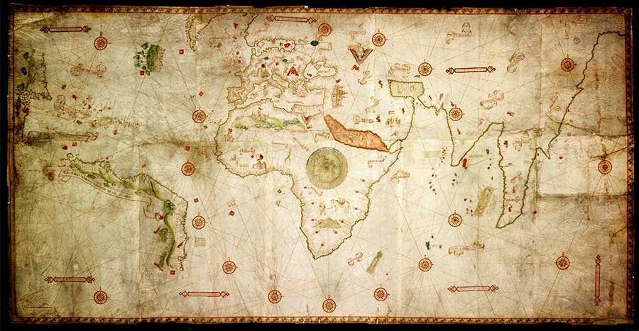
The Marine World Chart of
Nicolo de Canerio Januensis
Edward Luther Stevenson
This page presents the untitled first part of the work in which the chart is described, followed by the section on South America. Online editorial comments, corrections, translations, etc. are enclosed [in brackets].
Download the complete text at the Archive.org Universal Library website.
The Canerio Chart at Service Hydrographique de la Marine in Paris
Neither title nor date of execution appears on this marine chart which represents, in particular, the coast regions of the world as they were known at the beginning of the sixteenth century. As there is no original entry of a discovery after 1502, that date is given as approximately correct.
In the lower corner on the left of the reader [ie, near lower left corner of the chart] is the inscription, “Opus Nicolay de Canerio Januensis” [See Canerio entry on Maps page]. Little is known of Canerio save that which we are able to gather from his chart. He calls himself a Genoese, and to his pride in this fact he seems to have given expression several times on his map. The Antilles, as he says in a legend, were discovered “por collonbo ienoeize;” [by the Genoese Columbus]; he distinguishes the island of Lanzarote in the Canaries with the Genoese cross, as if to emphasize the enterprise of his countryman Lancelot Malocello at the close of the thirteenth centure; Genoa itself is distinguished by an elaborate building over which flies the Genoese flag; and in Africa he appears to magnify the importance of a kingdom which he calls “Regnum Musameli de Ginoia,” by placing over the king's castle a Genoese flag.† It seems probable that he was one of a number of Italians who found employment as map-makers in Portugal or Spain in those early years of great trans-oceanic discoveries. One would scarcely infer that he was a trained geographer, rather that he was a skillful draughtsman, an expert miniaturist, a copyist who did his work somewhat mechanically, often ignorant of that which he was transcribing.
† This flag may have been inserted to direct special attention to this kingdom of Musameli or to call attention to what appears to be a truth, that Genoese navigators had early been along this coast, or, as has been suggested, it may have been inserted by a Genoese possessor of the chart.
We are left to conjecture whether this excellent speciman of early cartography was produced in Portugal, the country whose language in the main is employed,† or in Italy, the native country of its author,‡ and whether it was executed on specific order, as was the Cantino chart, or is one of those maps, of which there were many, drawn by official cartographers in that day, and also perhaps by enterprising unofficial but expert map-makers, which maps could be purchased in the principal seaports of Spain and Portugal.
† Although Canerio employed in the main the Portuguese language, he occasionally reverts to his native tongue, to the Spanish and to the Latin. Like most of the contemporary cartographers he was not consistent in his spelling, which fact may have been due to carelessness, to the difficulty in deciphering the original from which he gathered his information, or to an imperfect knowledge of the Portuguese and the Spanish languages, hence a failure to understand the meaning of the names he found on the carts or in the written documents which he copied. He writes “Baia de tuti li Santi” insted of “Baia de todos santos.” In general he writes the word “de” for the Portuguese “do,” as “C. de Monte” where Cantino writes “C. do Monte.” Sometimes he makes use of the form “insulla,” occasionally “ilha.” Variations and peculiarities in spelling are exceedingly numerous.
In reading Canerio's names and legends one can appreciate the attitude of Chytraeus, in his attempt to translate the careless, ungrammatical Latin of the legnds on the Cabot map, who felt inclined to apologize from the language, and excuse himself fro the trouble because of the importance of the matter.
‡ Gallois thinks the chart must have been made in Italy: “Il me paraît impossible que cette carte ait été dessinée en Portugal. Presque toute la nomenclature, il est vrai, en est portugaise. … Ce portulan a dû être dessiné en Italie, et très probablement à Gênes, d'après un de ces modèles venus du Portugal, auxquels les Italiens attachaient alors tant de prix.” [“It seems to me impossible that this chart had been drawn in Portugal. Almost all of the nomenclature, it is true, is in Portuguese. This portolan must have been drawn in Italy, and very probably in Genoa, after one of these models that came from Portugal, in which the Italians attached much value.”] Harrisse is of the opinion that it “was constructed by a Genoese cartographer, most probably in Portugal; as, if he had executed his work in Italy, there would have been no reason for inscribing the legends in the Portuguese language, and he would have translated them into Latin.” Discovery of North America, p. 428.
That he made use chiefly of a Portuguese chart or or Portuguese charts in its construction, on which there had also been recorded Spanish discoveries as they were then known, is certain.
It belongs to that type of maps often called portolani,† maps in which the nomenclature is very largely limited to the coast regions. Rivers and mountains are not generally represented on such charts, especially on those we know of the fourteenth and early fifteenth centuries.‡ It appears that they were first constructed for the Mediterranean and its border lands, and that they were the outcome of practical seamanship, being intended to serve the mariner in guiding him from port to port. In time, after the beginning of Atlantic exploration, the portolano of the Mediterranean developed into a world map, still retaining most of the features of the earlier examples; such a world chart is Canerio's.
† Note in particular the admirable discussion concerning portolani in [Adolf Erik] Nordenskiöld: Periplus, an Essay on the early History of Charts and Sailing-Direction, Stockholm, 1897; particularly Chapters IV-VIII, treating of their character, standard of measurement, legends, sources, wind-roses, calendar diagrams, etc.
‡ Canerio has introduced a few landscapes into his chart. Mountains stretch along the entire continental coasts of the New World, and the parrot which interested so greatly the early discoverers, appears conspicuous in the Brazilian region. In the desert region of Africa appears his most conspicuous landscape, and in south Africa he has indicated the “Mons Lune,” although he does not represent these mountains as the source of the Nile River, which river is indeed omitted altogether. A lion appears in the Sierra Leone region, a giraffe somewhat farther east, and in south Africa a Mohammedan trader with his elephant bearing a burden of merchandise. In “tartaria” we find the “Magnus Tartarus” seated in his royal tent.
“Loxodrome” or “compass charts” they have likewise been called, on which rhumb lines are numerous, generally proceeding from a number of crossing-points which have been distributed with some regularity over the chart. These lines were doubtless also intended to represent the directions of the winds,† as the ornamental figures, wind-roses, often sketched at the crossing points clearly indicate. The ornamental figures have also been called compass-roses, it being implied that they owe their origin to the use of the compass, and that they were intended to represent the points of the compass as these points were drawn on the compass cards.‡ Though wanting scientific accuracy, such charts, as we know, were of great practical value for seamen in that early day of ocean navigation.
† In the ancient day direction was usually indicated by employing the name of the wind blowing from each particular quarter of the heavens. The idea was not forgotten in the middle ages, and in the period of great maritime explorations was revived and employed with some confusion. Direction came gradually to be expressed in terms of the points of the compass, but we find the windheads, that is, the winds, very frequently represented on charts of the fifteenth, sixteenth, and seventeenth centuries. Vespucci uses the term “maestral” in speaking of the northwest, and we still make use of the terms “Zephyr” and “Boreas” for the west and the north, though their use is rather poetic.
‡ Compass-roses usually have an orientation to the sidereal north clearly indicated, the point turned in that direction being usually extended into a figure somewhat elaborately sketched.
In making use of them for the determination of his course, the navigator would apply the compass to his chart, note the angle formed between the north as indicated by the magnetic needle and the direction in which he desired to sail, and with the resulting determination would proceed toward his destination, further guided by the lines laid down on his chart.
This marine chart is one of the oldest known on which wind- or compass-roses appear.† These roses Canerio has arranged in a regular system, such as became common in the sixteenth century, but in which arrangement no two manuscript maps are found which exactly agree. In a circle about his central figure, which appears in the heart of Africa,‡ he has indicated sixteen prominent crossing-points for his network of lines, at thirteen of which we find artistically constructed roeses, each with sixteen points, but at three of these points the completed roses are wanting. His scheme, had he followed a symmetrical construction, would call for thirty-two radiating lines, but in no instance is the number complete save in the case of the lines radiating from the large cental figure. On the right of the map appear three roses arranged as if part of a larger circle, and on the left three similar crossing-poings, at two of which the roses are sketched, but at the third or central crossing we find a crescent-like figure, which erroneously has been thought to indicate a Mohammedan flag and a belief that the region on or near which it is placeed was part of Asia, hence a Mohammedan country.
† Nordenskiöld observes that the oldest known portolano on which a compass-rose appears is the Catalan of 1375, there being, however, but one represented, and he further notes that but two other portolani are known prior to 1502 on which the compass-rose is indicated, in each instance but one rose. A marked feature of the Canerio chart is the grouping of the roses.
‡ This figure is a representation of the system of the world. In the center is a world chart, rather conventional in character. About this in concentric circles the seven heavens are given, the region of the stars, and encircling all the signs of the zodiac. It is interesting to compare this figure with those of similar character found on the chart of Fra Mauro, of Bianco, of Leardus.
At seven places on his chart he has sketched a ribbon-like scale of distances such as is common on maps of this type, divided into fifths and tenths.† Coast names are very numerous, most of which appear in black, many in red,‡ likewise a common portolan characteristic. It is also interesting to note that in his color scheme he has given the Red Sea its traditional reddish tone.
† See Nordenskiöld: Periplus, pp. 19-24, for an interesting consideration of scales of distances and the portolano mile.
‡ “The places marked by red are, with only occasional exceptions, invariably the same on all portolanos from the beginning of the fourteenth to the end of the sixteenth century. In the first place the more important pots have been honored with the red distinction, but this has been done in a very arbitrary manner, so at least it appears to us. Often it is not so much the size of a place as its suitability for a port of call, for provisioning or for taking in water, that seems to have determined the color by which it has been marked on the portolano. Perhaps too, the author of the normal portolano marked with red such ports as were indicated on the special maps which served as the basis of his work.” Nordenskiöld: Periplus, p. 18.
In the interior regions comparatively few names are given, chiefly such as are employed to designate particular countries or kingdoms. Among these, in the Old World, there being more than forty, we find such names as “hispania,” “francia,” “germania,” “tartaria,” “armenia,” “arabia,” “india exgangem,” “india superior,” “cattaio,” “egiptus,” “eptiopia,” “regum murfuli,” “regnum nubie,” “regnum musameli de ginoia,” and the names of such cities as “irusalem,” “mecha,” and the “turis babilonia,” with elaborately sketched buildings to emphasize the importance of each.
Along the border of the chart on the left Canerio has indicated, perhaps for the first time on a marine chart, degrees of latitude which extend from 56° south to 71° north latitude.†
† It has been thought by some that the King chart is the oldest known on which degrees of latitude are indicated, but like the Canerio chart it also is without indicated date, and this can not be absolutely determined from internal evidence. It is probably of the same date as Canerio's chart.
Employing his measure of a degree of latitude, we find he has represented about 250 degrees of longitude, the eastern coast of Asia terminating abruptly at the north, and the full extent of the western continent beyond the Atlantic coast-line being indicated as yet unknown.† He Africa and his Mediterranean coast lands are drawn with a remarkable approach to accuracy.‡ It is, however, in his representation of the newly discoverd lands of the West, of the African coast, and of the old though imperfectly known lands of the far East that the chief interest in Canerio's chart is found.
† He has not indicated degrees of longitude. The Carta Marina of Waldseemüller, which appears to be a copy of Canerio's chart, omits that part of the world lying between 152° and 280°, indicating therefore that the part of the world which has been sketched covers 232°
‡ For the region of the Mediterranean lands there is a striking contrast between the portolani drawn by practical seamen and the mediaeval maps drawn in the seclusion of the cloister cell. In comparison with the Ptolemaic maps for the same region, it is also to be observed that the portolani were drawn with a much nearer approach to accuracy.
South Continental Region—
South America
Canerio represents the entire north and east coast of South America included between the Gulf of Maracaibo and the mouth of the La Plata River. The appearance of the east coast-line, however, would scarcely indicate that a point so far south was intended, yet the terminus is in latitude 37° S., employing his own reckoning, and we have other documentary evidence that at least so much of the coast was explored between 1498 and 1502. Two Spanish flags are placed on the north coast, along which region a legend is also inscribed within a ribbon-like scroll: “Toda esta terra he descoberta per mandado del Rey de castella.” [“All this land has been discovered by order of the King of Castille.”] At the turn in the coast of Brazil from eastward to southward a Portuguese flag is drawn and a second one at its southern terminus.
Along the entire length of the coast-line stretches a mountain range with indication of forests, and, with scarcely the artistic touch of a Contino, we find four parrots conspicuously represented in the Brazilian region.
Very many of the names given appear here for the first time on a known chart. Cantino represents thirty-three coast names, Canerio gives fifty-eight, the islands indicated being included in each instance. It is practically certain that these names were given betwen the years 1498 and 1502, and doubtless by those who participated in officially authorized expeditions. While we can not always determine with certainty the exact landfall of each known Spanish and Portugues expedition to these coasts, the names we find recorded on the charts greatly assist in the settlement of certain disputed questions concerning early expeditions to this part of the New World.
Within the years degisnation we know of eight or more well authenticate visits to these coasts, not including what is sometimes given as Vespucci's first voyage of 1497, and that there are incidental references in the written records to many which may have been made to the same part or parts of the region indicated. Among these we may note first the third voyage of Columbus between May 30, 1498, and November 25 (?), 1500, with six or eight† ships, coasting the Orinoco or Amazon to Cumaná
† Las Casas: Historia de las Indias, Vol. II, p. 201, says six; Peter Martyr: Decades, I. Lib. vi, says eight.
Alonso de Hojeda, who had accompanied Columbus on his second expedition, and who was himself accompanied on this expedition by Juan de la Cosa and Amerigo Vespucci, sailed from a Spanish port in the summer of 1499, returning in April or June of the following year. He touched the coast of Paria, following it, it appears, as far as Cabo de la Vela, the present La Vela.†
† Las Casas, l. c., p. 268; Oviedo: Historia de las Indias, Vol. III, Cap. 3; Herrera: Historia de las Indias, Vol. I, Lib. iv, p. 125.
Peralonso Niño and Cristobal Guerra appear to have made an expedition, covering about the same time as the above mentioned expedtion, and to have visited in their one small vessel a section of the north coast of South America westward of the Orinoco.†
† Las Casas, l. c., Vol. II, p. 436; Navarrete: Collección, Vol. III, pp. 541-543.
About November 18, 1499, Vincente Yañez Pinzon [sic, Vicente Yáñez Pinzón] sailed from Rio de Saltes with four ships, returning with but two of these to Palos September 30, 1500. He doubled Cape Santa Maria de la Consolacion, January 20th, sailing northwest, passing the mouth of the Marañon (Amazon) and through the Boca del Drago to Haiti, thence homeward.†
† Navarrete, l. c., Vol. III, p. 547; Peter Martyr, l. cl, Decades, I. Lib. ix.
In December, 1499, Diego de Lepe sailed from Palos, touched the coast of Brazil, doubling Cape St. Augustine as he sailed southward, to which cape he appears to have given the name Rostro hermoso. Retracing his course, he met, doubtless by chance, the expedtion of Pinzon. His voyage carried him as far as the coast of Paria, whence he returned, reaching Palos in November, 1500.†
† Las Casas, l. cl, Vol. II, pp. 442, 453; Navarrete, l. c., Vol. III, pp.23, 544, 553.
The 9th of March, 1500, Pedro Alvarez Cabral left the port of Lisbon with thirteen vessels bound for Calicut. It may have been by accident that he touched the coast of Brazil, April 22d, at a point near the present Ponte Paschoal. He appears to have sailed as far north as the present Porto Seguro, and from this point Cabral departed for the Cape of Good Hope to conintue his voyage to Calicut, but Gaspar de Lemos was sent back to Portugal to carry the word of the discovery of a land to which name Terra de Santa Cruz was given.†
† Ramusio: Navigationi et Viaggi, Venetia, 1556, Vol. I. pp. 132-139; Humboldt: Kritische untersuchungen über die historische Entwickelung der geographischen Kenntnisse von der neuen Welt (Ideler's translation from the French) [Critical Studies of the historical development of geographical knowledge of the new world].
Rodrigo de Bastidas sailed in October, 1500, under letters patent dated June 5, 1500, to discover “islas e tierra-firme á las partes de las Indias, ó otra cualquier parte, con tal que no sea de las islas é tierra-firme que fasta [sic, hasta] aqui son descubiertas por Cristobal Colon ó por Cristobal Guerra.” [“islands and firm ground (mainland) in parts of the Indies or any other place, such that are not islands or firm ground that were discovered by Christopher Columbus or Cristopher Guerra.”] It appears that Andreas de Morales and Juan Rodriguez, pilots, sailed with him, as did also Juan de la Cosa. He first touched the mainland at some pointl along the Cumaná coast, sailed thence westward, at least to the Gulf of Darien and perhaps as far as Puerto del Retrete, including the entire coast of Panama. This part of the New World, however, Canerio omits from his chart. He returned in September, 1502.†
† Navarrete, l. c., Vol. III, p. 25; Oviedo, l. c., Vol. I. Lib. III, Cap. 9.
The above mentioned voyages are among those that are known to have been made to the north coast of South America prior to 1502.
In May, 1501, Verpucci made, as he tells us, his thrid voyage to the West, returning to Lisbon in September of the following year. The evidence is most convincing that he was the first to follow th coast of Brazil southward fo Monte Paschoal. To some one or other, then, of the expedtions here referred to, and in all probability to none more than to the voyage of Vespucci we must look for the origina of the majority of the names found on Canerio's chart. Indeed, it seems to me tha for a considerable part of the east coast indicated it may be regarded as the reproduction of Vespucci's chart.†
† Vide the translation into English: The first Four Voyages of Amerigo Vespucci, Quaritch, 1893; also the Latin version to be found in Waldessmüller's Cosmographiae Introductio.
Noting the names which appear along the coast of South America, as we have noted the names of the islands of the West Indies, and presenting these names from west to east, we find the following:
The island “Tamarique” seems, as Harrisse has noted, to have some affinity with Maracaibo. Yet we can not be certain of the origin of the name nor of the identity of the land.
Near the former name, appearing indeed as a part of it, is the name “.y. argua.” Cantino gives, ilha Rigua, which more nearly resembles the name Rica. In some of the early charts Ilha Rica seems to have been a name for Yucatan, and we find that for a considerable time that peninsula was indicated on the charts as an island. It is quite remarkable that it should be so given on the maps of Ribero as late as 1529.
In “arcay bacoia” Canerio appears to have been in doubt as to whether he was sketching an island or a peninsula. Las islas de Arquibacoa were discovered by Hojeda on his first voyage, which may be the name intened by Canerio.
On Riber's chart we find p. daraya given to a tongue of land south of the island Margarita, which was discovered and perhaps named by Niño and Guerra in 1499. On the modern map of Venezuela we find the small peninsula Araya.
The “insula de gigantes” was discovered by Hojeda in 1499 and given this name because his men were greatly impressed with the size of the native islanders.
“.y. do brasil” owes its name either to the fact that it was found to be a thickly wooded island or that dye-wood was here found in abundance.
“Gorffo [Gulf?] de linferno” may refer to Hojeda's battle with the Indians which took place in this vicinity in August, 1499, in which battle some of his men were killed. It is doubtless identical with Juan de la Cosa's Po flechado (the port of those shot with arrows). A gulf in this region bears to-day the name Golfo Triste.
The “Costa de gente braua” seems also to owe its origin to the expedition of Hojeda. Harrisse translates this, Coast of brave men; a better translation, it seems to me, is Coast of fierce (wild) men. Spanish cartographers were long accustomed to designate this as the Cannibal Coast.
The “Rio de fonsoa” suggests an effort to honor Bishop Juan rodriguez Fonseca, who had general charge of maritime and colonial affairs in Spain until the establishment of the Case de Contratacion in 1503. On the map of Juan de la Cosa we find, in this vicinity, r. del obp̄o (the river of the bishop). But it is not at all infrequent that such names refer to some member of an expedtion, and we can not be certain that we do not have here such an instance.
Where Canerio writes “Montagna altisimas,” Cantino has Montanhis albissimas, which Harrisse takes to be the correct form, believing they are the White Mountains first noticed by Bastedas on his expedtion of 1500.
The name “Cabo de las perlas” was given by Columbus, who visited the coast in August, 1498, on account of the pearl fisheries which he found here. Juan de la Cosa calls the entire coast of Venezuela Costa de perlas, as if to magnify the riches of the newly found country. In the summer of 1499 we learn that Guerra, Ni*ntilde;o, and Hojeda engaged in a very lucrative trade here with the natives.
“.y. de larapossa,” the she-fox island, is a name of unknown origin.
The name “las gaias” is the Spanish for magpie.
“.y. de los canbales” is a name given to a chain of islands discovered by Columbus in August, 1498. Columbus had called this chain, islas de los caribales. With an “r” changed to an “n” we have the word Canibales. Caribes he had carried home with him on his first voyage, and it was then thought to be a name given to a warlike, cannibalistic fold, a name he had heard in the island of Haiti. The name Isla Carib, las Islas de Caribes, it appears, was applied to various islands and to various groups of islands, and early came to signify the land or the islands of cannibals.
“la ponta delagalera” is a name which was given by Columbus, July 31, 1498, to this headland.† The name has long since disappeared from this part of the map, but it is not without interest to find that the name Bahia de la Galera de Zamba appears on the northwest coast of Colombia to-day. Gomara notes the identity of the native word Zamba iwth the Spanish word galera.
† Navarrete, l. c. Vol. III, pp. 553-554.
“Cabo deseado” (the desired cape) may refer to the character of the point of land named or to a fortunate experience after a mishap in one of the early expeditions. Harrisse, however, suggests that the original form was Cabo deseado, the meaning, therefore, being, the arid cape.
The name “Rio grande” is a name frequently met with on the early maps of South America. It seems probably, however, that the Amazon River is here meant. We have the record that Diego de Lepe discovered a river on this coast which he called Rio Grande de Santa Catalina, and in the deposition of Luis del Valle we find the reference, Rio grande que se llama Marañon.
The legend “Todo esto mar he de agoa dolce” [All this sea is sweet (fresh) water] refers to an observation made by Columbus on his third voyage, and it is altogether probable that the reference is to the more northern entrance to the Amazon River. In the “Gorffo fremoso,” which is located some distance from the indentation near which the legend just referred to may be found, we perhaps have a reference to the mouth of the Para River. Fremoso is an old form of the well known form, hermoso [beautiful].
The name “Cambales” doubtless owes its origin in this locality to the recollection of the conflict which Pinzon had with the natives, and to the belief that the men killed in battle were eaten by the enamy. The event is recalled in picture on many of the early maps, although some liberty has been often taken in the location of the scene.
The earliest information we have of “Sam Rocho” we get from the report of the expediton sent out by the Portuguese King in 1501 for the purpose of following up the discoveries of Cabral of the preceding year. This is the expedtion we find recorded as the third of Vespucci. From the name here given we learn that it touched this point August 16th, that being Sanctus Rochus day in the calendar of saints. Thence the expedtion sailed southward along the coast, “until the South Pole was at an elevation of 32 degrees about the horizon,” says Vespucci, and the names of many of the saints were given to rivers, bays and headlands,† on whose feast days the discoveries were made.
† The following are the saints' names found in the calendar of the Roman Catholic Church, which are inscribed by Canerio on the Brazilian coast of his chart:
| baie de reis (Ephiphany), | January 6. |
| Rio de Stō antonio, | January 17. |
| porto de Sam sebastian, | January 20. |
| porto de Sam vicenso, | January 22. |
| Alapego de sam paullo, | January 25. |
| Rio de sam iacomo (Jacobus), | July 25. |
| Sam Rocho, | August 16. |
| Rio de stā lena (Helena), | August 18. |
| Rio de stō augustino, | August 28. |
| Santa maria, | September 8. |
| Sam michel, | September 29. |
| Rio de sam ieronimo, | September 30. |
| Rio de sam fransesco, | October 4. |
| Rio de vergine, | October 21. |
| baie de tuti li santi, | November 21. |
| Rio de Stā lucia, | December 13. |
| Serra de sam tome (Thomas), | December 21. |
“Santa maria de gracia” is a name which would have been appropriately given September 8th.
“Monte de sam vicenso” seems to indicate a discovery on January 22d; if so, it doubtless was not named by Vespucci as he sailed southward. The Latin text of Vespucci's description of his third voyage gives the name St. Vincent where the Italian gives, el cavo do scô Augustino. The feast day of St. Augistine is August 28th.
“Stā maria de rabida” is clearly derived from the ancient convent of the Franciscan Friars dedicated to Santa Maria de Rabida, which is located not far from the port of Palos in Andalucia. It seems probable that it was named by some one who accompanied this expedition, to do honor to that convent.
“Cabo Stā croxe” is a point seen and named by Cabral April 23, 1500. It has, by some, been thought to be identical with the cavo di scô Augustino of Vespucci, with the Santa Maria de la Consolacion of Pinzon and with the Rostro Hermoso of Diego de Lepe. The point is perhaps identical with the Cabo de Santo Agostinho of to-day.
“Sam michel” is a name which was probably given September 29th. In the Diario of Lopes de Sonza (p. 15) we find a reference to a reef in this locality called Arrecife de Sam Miguel.
“Rio de sam Fransesco,” a name given to the largest river of the east coast of Brazil, perhaps October 4th. The name is found on the maps of to-day.
The name “vazia baril,” perhaps of Vespuccian origin, seems to indicate either the densely wooded banks of a river or a river where much dye-wood was found.
“Rio de perera,” literally translated, means pear river. Harrisse suggests that the name given may have been Rio de spera, or river of hope.
Just what mountains are designated by “Serra de stā maria de gracia” we do not know; perhaps those of the Province of Algoas which run down to the coast. On the Munich-Portuguese map we find in this locality Sancta Maria de Agoodia, which may designate a point where fresh water was obtained.
The origin and meaning of “Rio de caxa” is unknown.
The “porto real,” or King's port, is a name which appears on most of the early charts. We still find in this locality Rio Real.
“Rio de sam ieronimo” is perhaps of Vespuccian origin, being given on the 20th of September. In this name we seem to have the evidence that Vespucci doubled for a distance on his course.
“Rio de oido” is an unknown name.
“Rio de mezo” is likewise unknown.
The name “Monte fregosso” may be the name for a barren peak. A little to the south on some of the charts we find C. frio, and the name so appears on the charts of to-day.
The feast of All Saints falls on November 1st. It was doubtless on this day that Vespucci entered the bay to which he gave the name “baie de tuti li santi,” or, a baia de todos sanctos, as it appears on Cantino's chart. In the Italian account of his fourth voyage of 1503, where he speaks of it as the bay entered on the preceding expedition, he calls it la badia di tucti e sancti. On Waldseemüller's map of 1507 it appears as Abbatia omniū Sanctorum, a form which was often copied on the charts of a later date, and which owes its origin to a mistaken translation. This beautiful bay still bears the name Bahia de Todos os Santos.
“Rio de sam iacomo,” or, river of St. Jacob, appears to be a name given by some other expedtion than the one of 1501, to which most of the names after leaving “San [sic, sam] Rocho” owe their origin. The name would imply that it had been given July 25th, and this date would not fall in with those before given, besides we know that Vespucci was not on this coast in that month.
“Rio de stō augustino” was probably given by Vespucci, October 21st.
“Rio de stā lena,” if a name honoring St. Helena, it must have been given August 16th.
The origin of “Rio de sexmos” is unknown.
It appears that the name “Rio de vergine” was probably given by Vespucci, October 21, 1501.
The name “Rio de sam ioam” does not appear on any other early chart save on those which clearly borrowed from Canerio. The location and even the spelling suggest that by “ioam” Jorge may be meant. If identical, it was probably named by Cabral, April 24, 1501. Kohl observes that the name Jorge does not appear on any known early chart, but the date of St. George's feast day, April 24th, and the location on the chart not far from Porto Seguro leads me to suggest the identity of “ioam” with Jorge.
“porto seguro,” according to Ramusio, is the point from which Cabral sailed on leaving the New World.
The “bareras vermeias” appears to refer to a red bar.
“Rio de brazil” is the name suggested either by a wooded river bank or by the abundance of dye-wood here seen.
“barossa” appears to be the name for a muddy river.
“mont passqual” is the famous Easter Mountain which appears on most of the early charts. It was the first land sighted by Cabral, April 22, 1500, and by him the name was given because the discovery was made near Easter.
The name “Rio de Stā Lucia” was probably given by Vespucci, December 13, 1501.
As the name probably given by Vespucci December 21st, we find “Serra de sam tome,” or St. Thomas.
In “alapego de sam paullo,” a name probably given January 25, 1502, we have the earliest known cartographical reference to a village in the New World. Waldseemüller writes, pagus S. Pauli, in this locality. This may bear some relation to the present São Paulo, which city, however, lies somewhat inland. We know this to be one of the oldest of Brazilian cities, and it is probably that the name originated in the name given by Vespucci to an Indian village.
The “Rio da refens” can not easily be identified.
It appears that the name “baie de reis” was given by Vespucci January 6, 1502, which means, the bay of the Three Kings, or the bay of the Magi.
“pinachullo deteneio” (the mount or summit of the halting) is probably a name of Vespuccian origin, but when given we do not know.
“Rio iordam,” or Jordan, is a name frequently met with on the early maps, although Kohl remarks that the early historians mention but one River Jordan in America, and that in Florida. There is now no river in this locality in Brazil which bears this name, but we find that Schöner writes the name in about latitude 35° south on his globe of 1520, and that Ribero seems to give this name to the Rio de la Plata.
“Rio de Stō antonio” was probably given January 7, 1502. On the Ribero map of 1529 the name appears to the south of the entrance to the Rio de la Plata.
“porto de Sam Sebastiam” was probably named January 20, 1502, by Vespucci. The name Sebastiāo, given either to a headland, an island, or a city, frequently appears on the modern map along this coast. The ancient “porto ” was probably in the vicinity of othe present Ilha São Sebastião.
“porto de Sam vicenso,” doubtless given January 22, 1502, may have some connection with the present S. Vicente, which lies not far to the south of Ilha São Sebastião.
“Rio de cananor” marks the southern limit of Canerio's chart and appears to be the point near which Vespucci set sail to the southeast as he started on his homeward voyage. The name closely resembles that of an East Indian city, and it has been thought by some that it was given to this locality indicating a belief that it was not rfar from the eastern city, or that by this route one passed to that city. Such an explantion is not well founded. La Cananea is a feast day in the church—feria V primae Hebd. quadrag., and it seems probable the name was given in remembrance of this day. On the maps of to-day we find Cananea, which would appear to be identical with the “Cananor” of Vespucci.
No descriptive legend appears inland of this region, but to the east of the coast the following of some length is inscribed: “auera crus chamada per nome aquall achoui pedaluares cabral fidalgo de cassa del rey de portugall e aclle a descobrio in dopor capitanie de XII nauos que rey mandana a caliqutie nel caracho induto poi com esta terra aqual terra secrem esser terra furme em aquel he muita gente de descricavam nuos omes e mulieres como quas mais os pario sum mais biancos”: “The true cross, so called, which was discovered by Pedro Cabral, a gentleman of the household of the King of Portugal; and he discovered it as captain of thirteen (?) ships, which the King was sending to Calicut, and on this route he found this land, which is thought to be a continent where are many men who possess reason, and men and women, naked as their mothers bore them, only whiter.”