Fakes, Facsimiles & Forgeries
John Woram

NOTE: What's the reason for this page, which has nothing to do with the rest of this website? Glad you asked. It was originally posted elsewhere and after being subsequently deleted, some other map sites asked that it be made available once again. So, here it is. And a further note: the above “Return” button displays the rockvillepress.com Index of Books, Journals, Manuscripts. If you visited the current page from elsewhere, just close this window to resume viewing from that site.
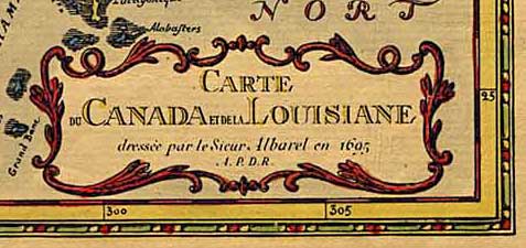
Carte du Canada et de la Louisiane dressée
par le Sieur Albarel en 1695 A. P. D. R.
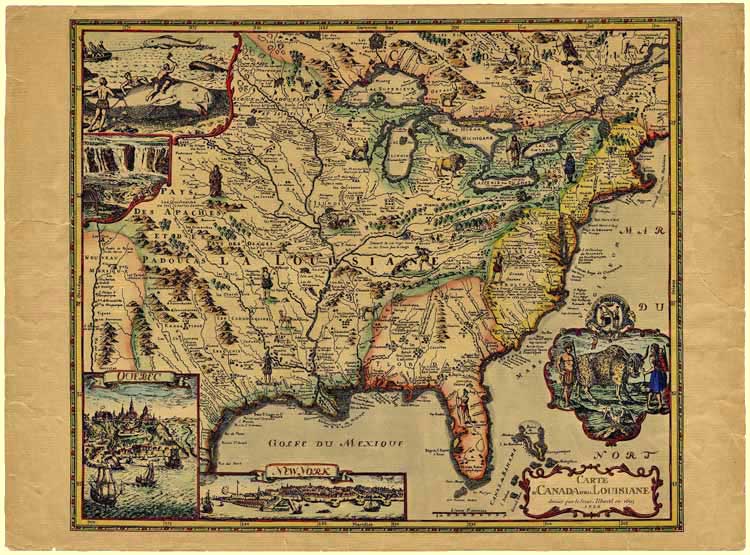
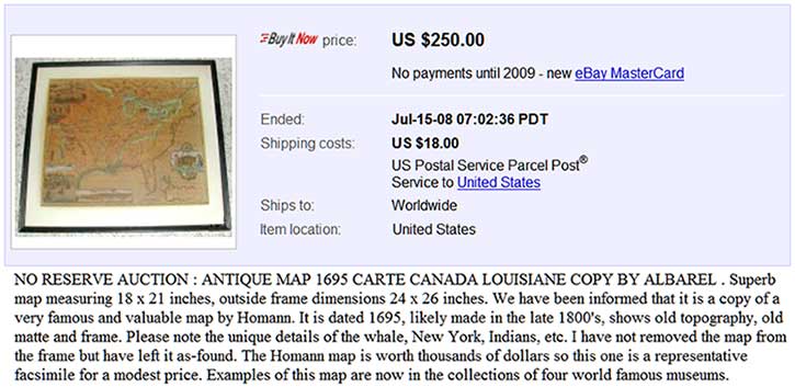

A hyrid fake-forgery. The geographical detail was presumably traced (by hand or in some mechanical way) from the Homann model (see below) and the lettering copied by hand. The map was then probably printed by photolitho, without a platemark, onto poor quality, artificially browned, modern paper. Surprisingly it is (or, was?) in at least four North American public collections (listed at bottom of page). Examples have appeared in the past on eBay, generally fetching under $ 50.00, although one was offered recently for $250 [Use magnifying-glass icon at upper right to view.] Yet another copy is currently available (April, 2015) on Murray Hudson's Antique Maps … website. Hudson places the publication date and venue as 1935, Paris.
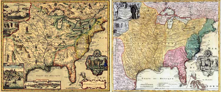
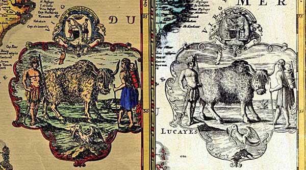
Left: Albarel Fake, Right: Homann, ca. 1719-23
-
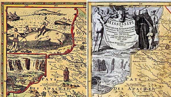
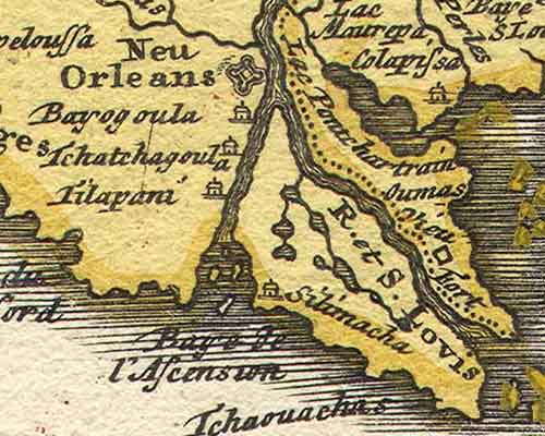
Geographical detail. This is taken from Johann Baptist Homann's Amplissimæ Regionis Mississippi (Nuremberg, Germany, between 1719 and 1723). 58 × 48.5 cm (shown above).
The Albarel faker inadvertently repeated the anachronism of “Neu Orleans”, which could not have appeared on a map until the city was laid out in 1718 by Jean Baptiste Le Moyne, Sieur de Bienville. [NOTE: Current detail shows Homann map only, while awaiting a better version of the Albarel image.]
- Bibliographical detail. The Homann original was in French, which made it logical for the faker to give it a supposedly French author. However, the name Albarel is unknown to the history of cartography. Coincidentally, perhaps, there was a French Jesuit explorer in Canada at around that time, Charles Albanel (1616-96), with a similar name. The 'A.P.D.R.' at the end of the title, standing for Avec Privilège du Roi, would, in the surprising absence of a publisher's imprint, indicate a (fictitious) Paris origin.
-
Illustrative details.
- Bison/Buffalo Scene: Copied directly from Homann with, above it, the arms of the French West Indies Company, and the inscription Ins. Gall. Societatis Indiæ Occidentalis.
- Title cartouche: Mid-18th century in style, this has been placed over part of the Bahamas detail. Early mapmakers did not obscure essential geographical detail in that way.
-
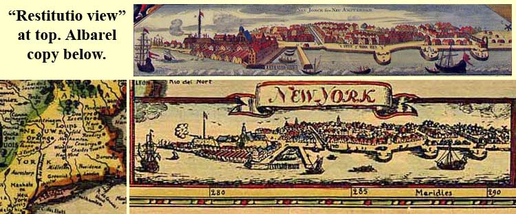
New York: A version of the so-called “Restitutio View” celebrating the brief Dutch re-capture in 1673. This was included on undated maps of New England (Novi Belgii) by Hugo Allard, Carol Allard, Joachim Ottens, Reinier & Joshua Ottens, Matthias Seutter and T.C. Lotter. That the Albarel version, unlike the Dutch or German models above, is headed simply with the English name (instead of variants of “New Amsterdam” or “New York”) does not mean that the faker made use of the rare John Seller form (in its final state). See:
- Campbell, Tony. New light on the Jansson-Visscher maps of New England. London: Map Collectors Series, 24.
- Tooley, R. V. The Mapping of America. London: Holland Press Cartographica 2.
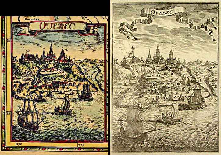
- Québec: Copied from Description de l'Univers. Allain Manesson-Mallet. Paris: Chez Denys Thierry, 1683.
- Niagara Falls: From the Homann model.
- Whaling scene [source not yet identified]: Placed within a copy of the two-part cartouche from the Homann map (the lower section of which includes the Niagara scene) this upper part had been used by Homann for his Latin title, set into a picture featuring a Native American, balanced by a European priest and soldier. In making an adjustment to the border between the two vignettes, the faker moved the lower border of the substituted whaling scene slightly, so as to obscure a small amount of geographical detail.
- Numerous small illustrations of Native Americans and animals [yet to be identified]
NOTE: For convenience when viewing the Albarel fake map at the top of the page, use the magnifying-class icons to view the just-described Illustrative Details.
2007: Albarel Map Held in the Following Collections:
- Alabama Department of Archives and History.
-
Bibliothèque et Archives nationales Québec, Collection Paul Riou. P428,P1 (06-M).
Note: Collation states “facsimilé en couleur,” perhaps in realization of the map's status. - East Texas Research Center, Stephen F. Austin State University, Map. No.211
- University of North Carolina at Chapel Hill Libraries, G3700 1695
April, 2015 Update: Each link above opens in new window/tab. Close that window/tab to resume viewing this page. Only links 2 & 4 now display Albarel information—no further information is available from these institutions.