

The Galápagos Charts of the 1793 Santa Gertrudis Survey
John Woram
NOTE:This page not yet finished, pending a bit more research.
There are five known charts attributable to the frigate Santa Gertrudis survey of Galápagos in 1793—numbered 1-4 in the Torres y Guerra listing and the fifth, a copy by Thomas de la Cruz Doblado. From notations on the latter, and on Chart 3, we know that these two are the work of Alférez§ Don Lorenzo Vacaro on the Santa Gertrudis. Presumably the others are by the same officer, but in the absence of positive proof, Charts 1-4 are all credited to Alonso de Torres y Guerra, the ship's captain.
§ The rank of Alférez has no precise equivalent in British or other English-speaking navies. It is thought to be somewhere between Ensign and 2nd Lieutenant.
Since charts 1-4 are undated, the 1793 date of the survey is given on the Maps page. A brief summary follows:
- Apparently a preliminary sketch map, this example shows no island names and lacks details found on subsequent charts. Someone wrote “Equador” [sic, Ecuador] at upper left, perhaps in or after 1832, the year in which Ecuador annexed the islands.
- Mar Pacifico title apparently assigned by Museo Naval, Madrid (magnifying-glass icon on chart shows title on back of chart),
- Isla Galapagos por la fragta Gertrudiz title written on chart.
- Additional details added, along with “Carta Esferica” and “Nota” texts in the lower corners.
- A finer rendition of Chart 2, and the first to identify Lorenzo Vacaro.
- As noted, this chart appears in Slevin's paper, but he offers no information about its source. It appears that it may be a page in a Spanish-language publication, but has yet to be identified.
- The Cruz Doblado chart appears to be a copy of Chart 3, above. Note “Carta Espherica” spelling.
Notes
Chart 1: The title (titulo) of this chart at the Madrid Museo Naval website is actually the title of Chart 5.
Chart 2: The Library of Congress description (Map 413) includes the following:
This map of the Galápagos Islands includes coastlines, the navigational track, and sightings by the crew of the frigate, Santa Gertrudiz, under the command of naval captain Alonso de Torres y Guerra, between March 18 and 21, 1793. The purpose of the expedition as given in a note on the map was to assess the potential economic and strategic value of the islands. This particular survey of the Galápagos Islands was part of a larger, complex scientific expedition made between 1789 and 1794 along the Pacific Coast of the Americas under the command of Captain Alexandro [sic, Alejandro] Malaspina† which was undertaken “por la beneficia de la Nav[egació]n y Comercio.” Torres y Guerra conducted the survey of the Galápagos Islands on the return voyage from Nootka Sound (North Pacific coast of North America) to Callao. This survey was the second official Spanish expedition‡ to the Galápagos Islands, and during it Torres y Guerra replaced the former British names of the islands with Spanish designations. This map, displaying only observed coastline and with unobserved landmass left blank, appears to be the copy made aboard ship during the expedition. A later 1794 version signed by Tomás [sic, Thomas] de la Cruz Doblado and housed in the Depósito Hidrográfico (Madrid) contains additional named islands. The earlier 1793 version is part of the Geography & Map Division's collection from the Real Escuela de Navegación, Cadiz, Spain purchased from Maggs Brothers, London. For more information about the expedition, see Carlos Manuel Larrea's El Archipielago De Colón. Quito: Editorial Casa de la Cultural Ecuatoriana, 1960.
† The expedition was under the command of Malaspina, but Malaspina himself was not present in Galápagos. See Journal of the Voyage … for more details.
‡ The Library of Congress description does not identify the first Spanish expedition to the islands.
Thomas de la Cruz Doblado
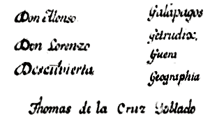
Note: The copyist's first name is “Thomas”—not the customary Spanish spelling of “Tomás.” His last name is usually written as “Cruz Doblado” elsewhere, although a style comparison of the letters “D” and “G” seen in the 1794 Carta Espherica text suggests it may be “Goblado.” However, “Doblado” is seen here, if only to follow the style found almost everywhere else.
The Cruz Doblado chart adds names to three unnamed islets seen on the 1793 charts. These may be the names of persons involved, however indirectly, in the Malaspina expedition, though not present on the Santa Gertrudis. The names may have been added by Cruz Doblado, acting independently. Tentative identifications are as follows:
- Mazarredo: Teniente General (Vice Admiral & cartographer) José de Mazarredo y Salazar (1745-1812). The Biblioteca Virtual de Defensa website describes an unrelated Carta de (from) Alejandro Malaspina a (to) José de Mazarredo, thus implying the two were acquainted.
- Solano: Royal Spanish Armada Capitán General (Admiral) José Solano y Bote (1726-1806).
- Tejada: Possibly, Juan Moreno de Tejada (1739-1805) an engraver during the reign of Carlos IV.