

Dating a Lava Flow at Beagle Crater
John Woram
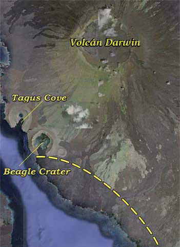
This Google Earth view of Isla Isabela's Beagle Crater reveals a characteristic seen on many Galápagos craters, which Charles Darwin explains in his Voyage of the Beagle (“Galapagos Archipelago” Chapter XVII, opening paragraph):
It is a remarkable circumstance that every one of the twenty-eight tuff-craters which were examined, had their southern sides either much lower than the other sides, or quite broken down and removed. As all these craters apparently have been formed when standing in the sea, and as the waves from the trade wind and the swell from the open Pacific here unite their forces on the southern coasts of all the islands, this singular uniformity in the broken state of the craters, composed of the soft and yielding tuff, is easily explained.
In other words, each crater's southern flank was gradually washed away as it emerged from the ocean depths. The Google Earth view shows that later on, a lava flow entered the crater through this opening, and the dashed line is a rough (very rough) approximation of a possible pre-flow shore line. The post-flow shore line makes it clear that the crater opening is no longer exposed to ocean currents. What's not clear though is the date of the flow, as there doesn't seem to be any written record of this event. For the moment, about all we can surmise is that it happened before Charles Darwin climbed the northwest rim of the crater, as described in his October 1, 1835 Diary entry:
To the South of the [Tagus] Cove I found a most beautiful Crater, § elliptic in form, less than a mile in its longer axis & about 500 ft deep.—Its bottom was occupied by a lake, out of which a tiny Crater formed an Island.—The day was overpowringly [sic] hot; & the lake looked blue & clear.—I hurried down the cindery side, choked with dust, to my disgust on tasting the water found it Salt as brine.
§ The Google Earth image shows Darwin's probable route from Tagus Cove to the Beagle Crater. The islets within the crater were named by Estes et al in 2000.
It's puzzling why Darwin tasted the water, because in his Notes on the geology of places visited on the voyage, § he writes that the crater was:
… open to S. & Seaward. — An immense stream of Lava from the mountain behind [now known as Volcán Darwin] has crossed the mouth [and] poured part of its contents inwards & part towards the sea. — Hence it is seperated [sic] by a broad tract of this substance.
From this account, it would seem that Darwin realized that earlier the sea flowed into the crater. And therefore, why bother tasting the water? For the moment, the question remains unanswered.
§ Darwin's Notes … may be viewed at the Darwin Online website. Search the page for “734 (9)” and later for “761 (16)” (omit the quotation marks). The latter is apparently Darwin's revised version of the former, written later in the voyage. When Darwin's notes were published as Geological Observations … in 1851, his southern-flank erosion explanation appeared within his Concluding remarks, while his Beagle Crater remarks appeared in his Craters of Tuff section.
At another island, we can assign a date range to a lava flow based on clues embedded in the lava. In Key Environments: Galapagos (1984: Pergamon Press, Roger Perry, editor), Tom Simkin's “Geology of Galápagos Islands” chapter notes the following (footnote, p. 18):
The prominent lava flow in James Bay contains fragments of marmalade pots stashed by buccaneers in 1684. The flow [but not the pots] was mentioned by Darwin,§ thus bracketing its age between 1684 and 1835: one of the rare uses of marmalade pots in volcano-chronology (bracketed phrase added to Simkins' text).
§ Darwin's Diary entry for October 11, 1835: “ We crossed a bare & apparently recent stream of Lava which had flowed round an ancient but very perfect Crater.”
But that was on one island, and Beagle Crater is on another. Unfortunately, we have no marmalade pots here, so this dating tool is not available to us. But what we do have is another tool. In David Porter's Journal of a Cruise, he writes of discovering in late April, 1813, a “beautiful basin” on the western coast of Albemarle Island—the modern Isla Isabela:
The art of man could not have formed a more beautiful basin, which is at the entrance about three cables' length over, and gradually enlarges to five cables' length, terminating in a round bottom.
Porter's description closely matches that of Beagle Crater, as it might have appeared before the lava flow sealed the entrance, and the 3 × 5 cables dimensions rule out the nearby Tagus Cove. Later on, he reports a June 6, 1813 eruption on Albemarle in the vicinity of Narborough (Isabela and Fernandina, respectively). As reported in Porter's account, the eruption date is confirmed by the Smithsonian Institution Global Volcanism Program.
Furthermore, in the second (1822) edition of his Journal of a Cruise, the Hooker map shows Port Rendevous [sic] as an inlet with an opening to the south. The magnifying-glass icon just below Banks Bay offers a close-up view of the inlet, which is clearly exposed to the ocean (shading added for clarity). So, if Port Rendevous is in fact Beagle Crater, then the lava flow that now enters the crater occurred after Porter's visit (April, 1813) and before Darwin's (October, 1835). The small islets within the crater may have formed at about the same time, and while Darwin's “apparently recent” remark (see footnote above) refers to the lava flow on James Island, perhaps the same remark could be applied to the Beagle Crater flow.
NOTE: Not related to the above in any way, but included here for general interest, many sources report that “The oldest documented eruption was in 1797 on Volcán Wolf” and then leave it to the reader to guess who documented this event. For those not inclined to play guessing games, it was Amasa Delano. In his 1817 Narrative of Voyages and Travels, he records an extract from the ship's journal, written “ … by the officer who had the care of the log book” on August 21, 1800 during a visit to James Bay:
We saw a large black cloud gathering over the highest mountain on Albermarle Island, which was the same place where one of the men on board our ship has asserted that he had seen a volcano burning in 1797.
Then unnamed, that “highest mountain on Albermarle Island” was of course Volcán Wolf. Delano does not name the crewman who had seen the eruption.