Part III: Island and Other Place Names


This document contains explanatory notes and background information on a few island names and a few placenames on various islands. For the former, click on any button to view the appropriate entry on one of the other pages. Entries are listed alphabetically, with prefixes (“Las, Bahía, Puerto” for example) ignored.
 A Note about Special symbols & Links
Symbols:  icon in an entry below indicates that entry contains links to Google Earth views of places named in the text.
As Google Earth views are no longer accessible from links in web pages, the KML files that hold this information must be opened in the Google Earth application. To facilitate this process a special access tool is offered here as KMLDownloader.
In Gary C. Williams' “History of Invertebrate Zoology at the California Academy of Sciences,” the author states (bottom of p. 224—p. 28 of PDF file) that:
The Academy's 1932 expedition to the Galápagos Archipelago sponsored by Templeton Crocker, left three fitting geographical names as a result of their explorations: Academy Bay at Puerto Ayora (Santa Cruz Island), …[plus two others].
In fact, Academy Bay was named some 27 years earlier, as reported by Joseph R. Slevin in his Log of the Schooner “Academy” (p. 53):
November 5: [1905] At 10:00 A. M. we made up to the anchorage, a small bay on the south coast to the westward of Puerta de la Aguada.§ … We named this bay Academy Bay, after the schooner, and it is now shown as such on the Hydrographic Office charts.
October 24: At 3:00 P. M. we made up to the SE coast [of Isla Santa Cruz] and dropped anchor in six fathoms at Puerta de la Aguada. …. The beach itself is fine white sand with gradual slope and well protected by reefs outside, so that it affords an excellent landing place.
The above describes a small beach (coordinates 0.709253° S, 90.22760° W) about one mile SSW of Playa el Garrapatero. Or it might be Playa el Garrapatero itself.
Admiralty Chart 1376

Borders re-drawn, anchorages (when present) shown in red, some text re-typed for clarity.
- Charles Island, Post Office Bay: This inset may be the first to show both Cormorant Bay and Cormorant Point, presumably added after the ca. 1886 survey by HMS Cormorant Navigation Lieutenant G. A. C. Webb. See Why are there no Cormorants at Bahía Cormorant? for more details.
- Chatham Island, Sappho Cove: The “island” seen in the inset is actually the tip of the peninsula to the north. The name of the cove is often mis-spelled as Caleta Sappo.
Isidro Ramon Antonio Ayora Cueva (1879-1978) served as President of Ecuador from 1926 to 1931. Although the city facing Academy Bay was named in his honor, it is not clear when this happened nor who was responsible. There follows a short list of citations mentioning (or in some cases, not mentioning) Puerto Ayora. The year preceeding the author's name is that in which the name is described, while the date (in parentheses) is the year of publication.
- 1926; Lundh: The Last Days of a Paradise (2006): It was also this group that founded Puerto Ayora, at the head of Academy Bay, …
- 1927 or later; Lundh: The Last Days of a Paradise (2006): Lundh also mentions two Norwegian founders by name: Gordon Wold and Kristian Stampa.
- 1927; Hoff: Drømmen om Galapagos (1985 & 2014): In a May 16 letter, Sverre Kiserud refers to the Santa Cruz settlement as “Ulvenæs” [“Wolfhill” in English].
- 1932; Slevin: The author writes that “Academy Bay, Indefatigable Island [was] locally known as Puerto Presidente Ayora …”:
- 1932-36; Wittmers (1936): What Happened on Galápagos? The Wittmers write extensively of boat travel between Isla Floreana and the Santa Cruz settlement, but never refer to the latter as Puerto Ayora.
- 1953-54; Johnsons: Yankee's People and Places (1955, p. 57): “We next put in to Academy Bay on Santa Cruz.” The Puerto Ayora name is never mentioned.
Some tentative conclusions may be drawn from the evidence (or lack thereof). As Lundh points out, Norwegian settlers arrived on Isla Santa Cruz in 1926 and founded Puerto Ayora some years later; apparently after 1927 (see Hoff, above) and perhaps in 1931 at the end of President Ayora's term of office. It's possible that the Norwegians at the Academy Bay settlement at first took to informally calling it Puerto Ayora, and the name eventually took hold among other settlers, even if there were no “official” decree so naming it, and if the “outside world” was slow to catch on. In fact, many writers—the Wittmers in 1936, the Johnsons in 1953-54, and others—had not yet heard of the name at the time they wrote their accounts. And now, all that remains is to find the first occurrence of Puerto Ayora in print.
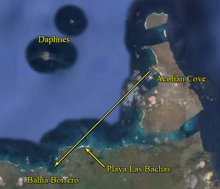
When American military forces left Isla Baltra at the end of WWII, two water barges, previously used to transport water from Isla San Cristóbal, drifted over to the north shore of Isla Santa Cruz, where they were abandoned. Ecuadorian residents of the island mis-pronounced “barges” as “bachas” and the beach became known as Playa Las Bachas (Beach of the Barges). A Google Earth photo at the Bahía Baquedano entry below shows the location of the beach.
Bainbridge's Rocks

David Porter originally described “ … two rocks that lie off the north end of Porter's Island which we have called Bainbridge's Rocks.” According to the Hooker map in Porter's book, these rocks were in fact east of the present Isla Santa Cruz. These rocks are now known as Gordon Rocks (Rocas Gordon) and this name appears for the first time on a map drawn by G. W. P. Edwardes, HMS Daphne. Porter's original designation was subsequently applied to other rocks (8 of them!) off the coast of Isla San Salvador.
Baltra & Itabaca/Ilabaca
Contrary to some reports, the name is not an acronym derived from Base Aerea para Logística y TRAnsporte (or similar) bestowed by the American armed forces during their WW II occupation of the island. At present, the earliest known appearance of the name is in Part III of the 1927 edition of the British Admiralty's South America Pilot (p. 358):
Bahia Baquedano, on the north coast of Indefatigable island, westward of Isla Baltra, the southern and larger of the Seymour islands, affords good anchorage abreast of a sandy beach and close southward of Birs cove on the latter island.
Canal Ilabaca, separating Indefatigable island from Isla Baltra, is available for boats.†
The previous (1915) edition does not show the above information. The Admiralty Hydrographic Department copy does however bear this handwritten notation: “Names. __ Baltra I. & Puerto Nuñez H 214/15.” This is an indication that these names are to be added to the next edition, and H 214/15 indicates a document containing source information. Unfortunately, the document cannot be located, and is presumed to be lost. And so therefore, is the origin of this name.
Maps & Charts: An inset on a Pacific Ocean map (National Geographic, December 1936) marks the first known occurrence of the name Baltra on a map. Later, a 1942 chart issued by the United States Hydrographic Office is the first edition in a sequence of charts of Islas Baltra, Mosquera and Seymour Norte. It lacks the details (airstrips, roads, etc.) found on the subsequent 1943 chart issued by the U. S. Army Corps of Engineers. This chart was
first printed with a “Seymour Island” label. At a later date, “Seymour” was crossed out and “Baltra” printed above the cross-out. See “Study of the U. S. Air Forces' Galapagos Islands Base” [Page 8] for explanation.
Named after the Chilean corvette General Baquedano, the descriptions of the bay (in the Baltra section immediately above) as “westward of Isla Baltra” and “close southward of Birs (now, Aeolian) cove” are contradictory. Perhaps the latter should be southwest instead. If so, Bahía Baquedano is the modern Bahía Borrero,§ as shown here:
- Antonio Borrero, 1875-1876,
- Ramón Borrero y Cortázar, 1883-1884,
- Manuel María Borrero, 1938.
Breakfast Island, Breakfast Islets
In all three logs of HMS Beagle, the entry for Saturday, 10th October 1835 includes the following three bearings (numbered here for reference purposes:
| 1: West Extreme of James Isl. | S 81° 40' W. |
| 2: Peak on Breakfast Isl. | S 52° W. |
| 3: Rocky Isl. | S 14° 30' W. |
Although the Beagle's approximate location on that date is known, its exact position is uncertain, as indicated by these three interpretations:
-
View A: If Bearing 1 is interpreted as the westernmost part of James Island that could be seen at that time, then Bearings 2 and 3 pass through Bartolomé and Daphne Major respectively. However, it was FitzRoy himself who named Bartholomew (now, Bartolomé) Island in honor of Lt. Bartholomew Sulivan, HMS Beagle, as shown on an inset on Admiralty Chart 1375. It would therefore be unlikely for the log to refer to the same island as Breakfast Isle.
-
View B: If Bearing 1 is interpreted as a westerly peak on James Island, then Bearings 2 and 3 pass through the Beagle Islets and Daphne Major, respectively. This interpretation is also unlikely, because the Beagle log consistantly refers to other volcano bearings as “peak” or “summit.” However, this does allow Bearing 2 to agree with FitzRoy's statement described immediately below.
-
View C: If the “West Extreme of James Island” bearing should have been written as East, then “Breakfast Isle” is in fact one of the current Beagle Islands, and the “Rocky Islet” is one of the Guy Fawkes islands. This agrees with FitzRoy's statement in his Documents Sent to the Hydrographer of the Admiralty Sept 16, 1844, where he writes (ms. p. 8) that “Four miles East of Jervis Islet [ie, Rábida], are the little Breakfast Islets.” A detail map shows the modern Islas Beagle are in that location.
To further confuse the issue, some whalers had actually applied “Breakfast Isle” to the modern Isla Rábida, as cited in the log of the whaler Hector, Capt. Thomas Norton.
Cartago Bay (Cruiser Bay)
The alternate “(Cruiser Bay)” is a puzzler, because the Spanish-to-English translation of “Cartago” is “Carthage.” Possibly the bay was named after HMS Carthage, and the “(Cruiser Bay)” is in error.
Champion Island (Isla Campeón)
Alexander Champion was a partner in the London whaling and sealing company, Samuel Enderby & Sons. In 1793 the company sent the merchant ship Rattler, James Colnett, to Galápagos, where he presumably named two small islets to the east of the modern Isla Floreana after the partners. Champion's first name is often seen in error as Andrew.
Although Isla Campeón is now the island's official name, strictly speaking it should be Isla Champion, since it is named after the man, not the Spanish translation of “champion.”
Charles, King Charles II
This section offers evidence to support the claim that Cowley's “King Charles the Second's” Island is in fact the present Isla San Cristóbal.
According to most, if not all, post-Cowley/Hacke/Moll charts, the island that Cowley called King Charles the Seconds, is the present-day Isla Santa María/Floreana. Yet in reading Cowley and Dampier, one is struck by the fact that it would be almost impossible for them to have seen this island first. In fact, using nothing but their own descriptions of the voyage, it appears quite likely that they never even came close to the island now said to be the early Charles.
Cowley's “Your Grace” letter is the first recorded description of their arrival:
About the end of the month we saw an island bearing southwest of us. But there ran so great a current that seteth to the northward that I could not fetch it. … This island I gave the name of King Charles the Second's Island, by reason that it was the first that I saw. I judge that the body of that island may lie near one degree south latitude … ”
In Sloane Ms. 1050 (and others), Cowley states that . . .
The first island that we saw lay near the latitude of 1°30' South. We, having the wind at South & we being on the North side thereof, that we could not get to it to discover what was upon it. This island maketh high land, lying in the longitude of 278°[87°] or there about. This [island] I named King Charles the Second's Island.
We seeing many more to the westward, we made to them & we got in and …
If their ship were on the north side of the present Santa María, there would be no point in attempting to reach it since, given the “wind at South,” it would have been easier to reach the present Santa Cruz. Also, his report of “seeing many more [islands] to the westward” suggests he was off the present San Cristóbal, where there are indeed islands to the westward.
Dampier's description further supports this claim. He writes that . . .
… the ship that I was in … anchored on the East-side of one of the Eastermost Islands, a Mile from the shoar, in sixteen Fathom Water, clean, white, hard sand.
Modern detail charts show that only the eastern extremity of Isla San Cristóbal agrees with his description of the anchorage. The soundings off Santa María are far greater, and the bottom is rocky—not clean white hard sand.
Dampier further reinforces the case for being nowhere near Santa María/Floreana, by mentioning a later voyage of Captain Edward Davis, who “went to other Islands on the West-side of these. There he found also plenty of Brooks of good Fresh-water.” In 1712, Captain Woodes Rogers also writes in his A Cruising Voyage Round The World of Captain Davis, and of “the Island S. María de l'Aquada, reported to be one of the Gallapagos, where [according to Davis] there is Plenty of good Water.” The description fits the present Santa María, which is indeed west of San Cristóbal. West of Santa María is the barren southern end of Isabela/Albemarle, an island known to Cowley and Dampier, although they did not reach this end of it.
This examination of Cowley and Dampier suggests that Charles is none other than the present San Cristóbal, and that it could not possibly be Santa María. The subsequent mix-up came about as an inadvertent error introduced by Captain James Colnett, who visited the area in the merchant ship Rattler in June, 1793. In his Voyage to the South Atlantic and Round Cape Horn into the Pacific Ocean, Colnett clearly describes and positions the islands known today as San Cristóbal/Chatham and Española/Hood. However, he does not realize that San Cristóbal is in fact Cowley's Charles: “As I could not trace these isles, by any accounts or maps in my possession, I named one Chatham Isle, and the other Hoods Island” and for those who have trouble following things, he helpfully adds “after the Lords Chatham and Hood.” A 1798 Galápagos chart by Aaron Arrowsmith is found in Colnett's book, and this may mark the first place in which Cowley's Charles is applied by mistake to the present Santa María/Floreana.
The mix-up did not escape the attention of James Burney. In Volume IV of his 1816 A Chronological History of Voyages and Discoveries in the South Seas, he writes of an island (Santa María) that Colnett
… appears to have mistaken for the King Charles's Island of Cowley's chart. On comparing Captain Colnet's [sic] chart with Cowley's, it is evident that Captain Colnet has given the name of Lord Chatham's Isle to Cowley's King Charles Island.
To reinforce the point, Burney inserts an island to the lower center of Cowley's chart. A note below the chart states that “The Island Santa María de l'Aquada, according to the situation from Albemarle [Isabela] Island, is added from the Chart published by Mr. Arrowsmith.” The general outline is identical to the Charles Island group seen in the Arrowsmith chart. To summarize, Burney has correctly placed the island of Santa María, and restored Charles to its rightful place.
HMS Beagle Captain Robert FitzRoy also recognized the error: in his Narrative … he describes approaching …
… the north-east end of Chatham Island. (Charles Island of Cowley, 1684).
Osbert Salvin was yet another who recognized the Charles/Chatham connection: in his “On the Avifauna of the Galapagos Archipelago” a footnote (p. 448) pertaining to island names includes the following:
The Charles Island of Cowley is probably the same as Chatham Island of Colnett, not the Charles island of the chart, § and is perhaps the Santa Maria de la Aguada of the Spaniards.
Other authors have noted the island became known as Floreana, as in this example:
In Voyage of the United States Frigate Potomac, J(eremiah) N. Reynolds writes (p. 464) that:
“We remained at Charles's Island, which the new colonists call La Floriana.”
The Potomac was under the command of Commodore John Downes, formerly a first lieutenant on David Porter's Essex. (See Chapter I “Crew List” in Porter's Journal of a Cruise ….)
Chatham
In bestowing names on various islands, Colnett writes (p. 60) that:
I named one Chatham Island [Isla San Cristóbal] and the other Hood's Island [Isla Española], after the Lords Chatham and Hood.
The identity of “Lord Chatham” has been stated to be one of the following:
- William Pitt, the elder—First Earl of Chatham (1708-1778)
- William Pitt, the younger (1759-1806)
Note that the elder Pitt was never a Lord, and had died some fifteen years before Colnett visited Galápagos. At the time of that visit, the younger Pitt was Prime Minister and recently appointed (1792) Lord Warden of the Cinque Ports. It is therefore assumed here that Colnett's “Chatham Island” was named in honor of William Pitt the younger.
Daphne Isles

See Notes for G. W. P. Edwardes for details about this name.
Darwin, California

Darwin, California (2000 population 54) is named after Army Physician Dr. Erasmus Darwin French (1822-1902), who may have been named after Charles' grandfather Erasmus. Each year a Charles Darwin enthusiast arranges for envelopes or postcards to be postmarked on Charles' birthday of February 12th. The 1830 date on the “Harriet the Tortoise” envelope is the approximate year of her birth, according to those who claim she was collected by Darwin in 1835. The 2005 postcard has no Galápagos connection, but is included here as part of the series. Others (if any) have not yet been located.
The Appendix to Charles Haskins Townsend's The Galápagos Tortoises … shows the following entry in the log of the whaler Abigail:
May 15 [1834, coming from Post Office Bay, Isla Floreana]—“steering for Porter's Island [the modern Isla Santa Cruz] 4 P M Came to Anchor in Downes Bay in 7 fathoms.”
This is the only known occurrence of the name Downes Bay, which in context seems to be one of the following:
Note 7-fathom anchorages and anchor symbols on both charts. For the moment, the former is thought to be the most-likely anchorage. Its name in the log may be a reference to John Downes, a lieutenant on David Porter's frigate Essex, and later commodore in command of the frigate Potomac. The Downes Bay name does not appear in the accounts of the Potomac visit to Galápagos by Jeremiah N. Reynolds and Francis Warriner, and it is unclear why this name is found in the Abigail log. To rule out the possibility that someone else named Downes was in the ship's crew, that name does not appear in the
Abigail Crew List at the New Bedford Whaling Museum. There was however a Charles Downes on the ship Balaena in 1818, but that ship's log has not yet been examined.
Edén (or Eden)
An Admiralty Chart 1375 inset, ca. 1844 and credited to HMS Daphne Midshipman G. W. P. Edwardes, shows “Conway Bay” and an unnamed islet at the location of the present Islote Edén. A subsequent revision names the islet “Eden.” Henry Eden was captain of HMS Conway 1832-39, and became First Lord of the Admiralty in 1846. The Conway was in Galápagos in 1846, and Edwardes apparently named the bay in honor of that ship, as may be seen on his own Galapagos Islands chart.§ (“Indefatigable” enlargement shows the names of both the bay and the islet.) Perhaps an Admiralty draftsman noted the omission of Eden's name on the Conway Bay inset, and added it to the subsequent chart revision. Still later, an Ecuadorian draftsman apparently mistook the Eden name for the Spanish equivalent of “Paradise” (Edén) and that is now the island's official name.
Note: The Galápagos National Park "Guide to Visitor Sites" shows a Spanish/English “Edén Island” in its list of Marine Visitor Sites, and “Islote el Edén” (emphasis added) is seen in many scientific papers and on tour operator websites.
Encantadas (or Enchanted, Inchanted)
Although popular legend has it that the Spaniards dubbed the islands Las Encantadas, the only known records of this name and its variations are as follows:
| Date | Name | Comments |
|---|
| 1684 | Enchanted | Cowley states that the Spaniards told him the Galápagos were “enchanted islands,” but does not mention any map or text where this term might be found. |
| 1775 | Inchanted | Sayer is the first known cartographer to apply the name to the islands. |
| 1794 | Laurie & Whittle followed Sayer's example. |
| 1854 | Las Encantadas | Melville used the phrase as the title of his series of ten sketches. |
| 1985 | John Hickman cites Diego de Rivadeneira as the originator of this name. |
There are no known maps by Ortelius or any other cartographer (except as noted above) on which this name appears.
Gordon Rocks
See G. W. P. Edwardes Notes for details about this name.
Hawk
The name appears on the following three charts:
| Date | Cartographer | Chart Title | Island Name |
|---|
| 1822 | J. M. Hacq | Carte des Iles Gallapagos … | I. Hawk |
| 1842 | Dortel de Tessan | Carte d'une Partie … | I. Tower ou Hawk |
| 1880 | Adolph Stieler | Polynesien und Der Grosse Ocean (with Galápagos inset) | Tower (Hawk) I. |
The English “Hawk” presumably refers to the frigate bird, also known as the “Man-of-War Hawk” from its habit of attacking other birds in flight. An island with that name would suggest that English-speaking explorers visited the modern Isla Genovesa, noted the presence of the birds, and named the island accordingly. The appearance of the name on the above charts suggests that it was copied from an English-language source. However, there is no known record of English speakers visiting the island, nor of an English-language chart showing that name. Given that the equivalent words are “Faucon” in French and “Falke” or “Habicht” in German, the reason for the English “Hawk” instead of its French or German equivalent remains unknown, pending further research.
Isabel, Isabela, Isabella
Although the island formerly known as Albemarle was officially designated Isabela in 1892, note that the name appeared more than a century earlier on these maps:
Their sources for the name are unknown.
Jensen
Jacob “Jake” Lundh [1928-2012], who spent much of his life in Galápagos, reports that the island is named after J. A. Jensen, who came to Galápagos with the cannery group. Known locally as “Fisker Jensen” (Fisherman Jensen), his given names are unknown.
In Stein Hoff's Drómmen om Galapagos, the “Shareholders and Crew” table indicates that Jensen—a fishing expert from Egersund—reached Galápagos on the Ulva.
Nightmare Island
Notwithstanding the following comments:
- Zane Grey, p. 77: “Tower Island. The Spaniards of Guayaquil called it Nightmare Island, … .”
- Captain and Mrs. Irving Johnson, p.74: “The Spanish name, Nightmare Island, seems much more suitable than [Tower].”
There is no known record of the Spaniards of Guayaquil (or of anywhere else) referring to Isla Genovesa/Tower as Nightmare Island, which would be Isla Pesadilla in Spanish. Perhaps Grey thought “Quita Sueño” (without sleep or dreamless) meant “nightmare” and mistakenly attributed the source to Guayaquileños. Later on, Electa (Mrs. Irving) Johnson may have used Grey as her source.
Onslow Islets
See G. W. P. Edwardes Notes for details about this name.
Porter's Island
As noted in Porter's Journal, Chaplain David Adams mistakenly(?) named Norfolk Island (Isla Santa Cruz) as Porter's Island. Although the name did not last very long, it was used occasionally by other mid-19th century visitors, such as Francis Warriner, who wrote that:
Another party, under the charge of the first lieutenant, the purser, and midshipman Sinclair, took a boat load [of tortoises] of enormous size at Porter's Island.
Woodes Rogers refers to a “Remarkable Rock,” a “Rendevouz Rock,” and “the Rock,” which in context are the same rock (pp. 151, 152, 153 in 1928 Dover reprint edition). He states (p. 151) that it is “… about 2 Leagues (6 miles) off Shore.” Given his description of other locations in the vicinity, and its distance off shore, it seems likely that this “rock” is the modern Islote Cinco Dados (five fingers).
The Rockpile
Forrest Nelson was a radio operator/navigator on American tuna boats in the early 1950s before settling in Galápagos. According to the late Galápagos historian Jacob Lundh, Nelson subsequently married Friedel, daughter of Norwegian settlers Jacob and Elfriede Horneman, and together they founded Hotel Galápagos (or “Hogal”). In about 1962, he set up a ham short-wave radio and often communicated with the tuna fleet. Nelson's “footloose dropout son” (his own description) Jack came to visit in 1967, returned permanently a year later, and eventually took over the management of Hogal, which he sold a few years ago. According to Jack, his father often assisted visiting tuna fishermen, who informally referred to the islands as “The Rockpile.” And Jack himself often heard the term when listening to the “Tuna Net” in the 1970s.
Isle de Santé
de Villefort writes the following:
The Isle de Santé … is 20 leagues from Isle à Tabac.
Assuming the latter is Isla San Cristóbal [see Isle de Tabac below], Isla Santa María is about 22 French Leagues (about 56 miles) distant.
At a league (about 2.6 miles) distance from a Bay [probably, Post Office Bay] at the NW part of Santé, I found a small spring of fresh water, the only one met with.
The distance from Post Office Bay to the spring on Isla Santa María is about 4 miles—reasonably close to de Villefort's estimate.
Arrecife Schiavoni

Practically all online sources give the wrong coordinates for Arrecife Schiavoni, placing it either at about ½ mile north-northwest of Punta Lido, or southwest of the position shown in the Google Earth view given here, which is based on an Armada del Ecuador Derrotero, Section 6.4.2.7, Recomendaciones de Seguridad (PDF download, p. 161 of 199). An English translation follows:
Arricefe Schiavoni is at the entrance of Wreck Bay, 0.6 miles southwest of Punta Lido.
The reef's correct location is also shown on Admiralty Chart 1375.
The “Ships” button above links to the ship Turul, which probably was a casualty of the reef.
Seal Island
The name is seen on a sketch map of Isla Floreana by Nichols, at the approximate location of Punta Cormorant. Since Punta Cormorant is not an island (or islet), it is uncertain why the name appears here. The nearest islet is Corona del Diablo, which would certainly not be thought of as a “seal island.”
Seymour Isles
See Notes for G. W. P. Edwardes for details about this name.
Isle de Tabac
Various sources attribute the Isle de Tabac map to the log book of French frigate Phélypeaux, Captain Jacques Gouin de Beauchêne. However, given the elegance of the image (colors, font style, etc.) it may have been re-drawn from the log book.
The image appears to have been clipped on both the left and right sides (note absence of borders). The French text describes four items (A-D), although B is missing—perhaps a casualty of the clipping. Item A appears to be Kicker Rock, in which case—despite the error in orientation—Isle de Tabac is the modern Isla San Cristóbal. But with regard to item D—Careening place of the [English] buccaneers—there is no such place on this island. The well-known Buccaneer Cove is on the modern Isla San Salvador, so there is no satisfactory explanation for its presence on this map.
To further confuse the matter, Ensign Sieur de Villefort, serving aboard de Beauchêne's Phélypeaux, wrote the following [as quoted by James Burney]:
Our boat found a good port, sheltered by a small Island, the entrance of which is to the West. … we knew it to be the Isle à Tabac, where the English Buccaneers had used to careen. The Isle de Santé where we anchored on June the 10th, is 20 leagues from Isle à Tabac, and is also burnt up.
The small island [presumably, Isla Albany] and the careening place suggest the island is the modern Isla San Salvador, known to the buccaneers as King James Island. However, de Villefort's reference to the 20 leagues (about 50 miles) between Isle de Santé and Isle à Tabac suggests the latter is the modern Isla San Cristóbal, as mentioned above. Yet, there is no “good port, sheltered by a small Island”—neither at the location (D) shown on the map, nor elsewhere along the northern coast of the island.
Given this conflicting information, it would seem that James Burney had the last word:
There can be no certainty which of the Islands in the chart of the Galapagos were intended in the foregoing description.
Notwithstanding Burney's remark, this site assumes that item A is indeed Kicker Rock, and therefore Isle de Tabac is the modern Isla San Cristóbal.
Tower (Dowers)
The 1815 Fyffe chart listed below displays the first appearance of the name Dowers's for the island now known as Genovesa/Tower. This chart also identifies the present Isla Santa Cruz as Porters Isle, so it is clear that Fyffe knew of David Porter's earlier visit on the United States Frigate Essex. He therefore may have also known that Lieutenant John Downes of the Essex reported the position of this island to Captain Porter, and if so he may have assigned the Lieutenant's name (but mis-spelled as “Dowers”) to the island.
The Hooker chart in the second edition of David Porter's Journal of a Cruise shows the same island but with no name assigned to it. A note on the chart states that the island is “ … situated agreeably to the reports of several Whalemen, and corresponds to the position in which it was seen by Lieut. Downes.” Presumably, Porter himself left the island un-named because the whaler reports known to him did not include a name, and he had already given the name Downes to the island now known as Pinzón.
The island appears on the 1827 Vandermaelen map with the name “I. Dowers” next to it, which may either be a misinterpretation of Porter's reference to Lt. Downes or a repetition of Fyffe's usage. Benjamin Morrell may have mis-read Fyffe or Vandermaelen's Dowers as Tower's, and thus the sequence becomes:
The name first appeared on a 1798 “Chart of the Galapagos, …” by Aaron Arrowsmith, and is clearly seen in a detail view taken from the 1808 edition of the same chart. The chart first appeared in James Colnett's Voyage to the South Atlantic, while subsequent editions (1808 & others) were published separately. “Wreck Bay” may have been so-named by Arrowsmith based on Colnett's text (p. 141), in which he describes a wreck, but does not name the bay in which he saw it.
For reasons unknown, some modern sources (Galápagos Online and elsewhere) mis-attribute the name, as seen here:
Just outside of the port itself are the remains of Caragua a WWI German transport ship, this 100-year-old wreck whose sinking gave the bay its name – Wreck Bay.
The original source of this mis-information remains unknown, pending further research.